LiDAR 1m DTM Hillshade
Satellite Imagery
LiDAR 1m DTM Hillshade
Satellite Imagery
Scroll left/right to view further images.
HER: Wiltshire and Swindon MWI19460 (None)
NMR: SU 27 NW 4 (225113)
SM: 1016312
NGR: SU 2081 7971
X: 420869 Y: 179704 (OSGB36)
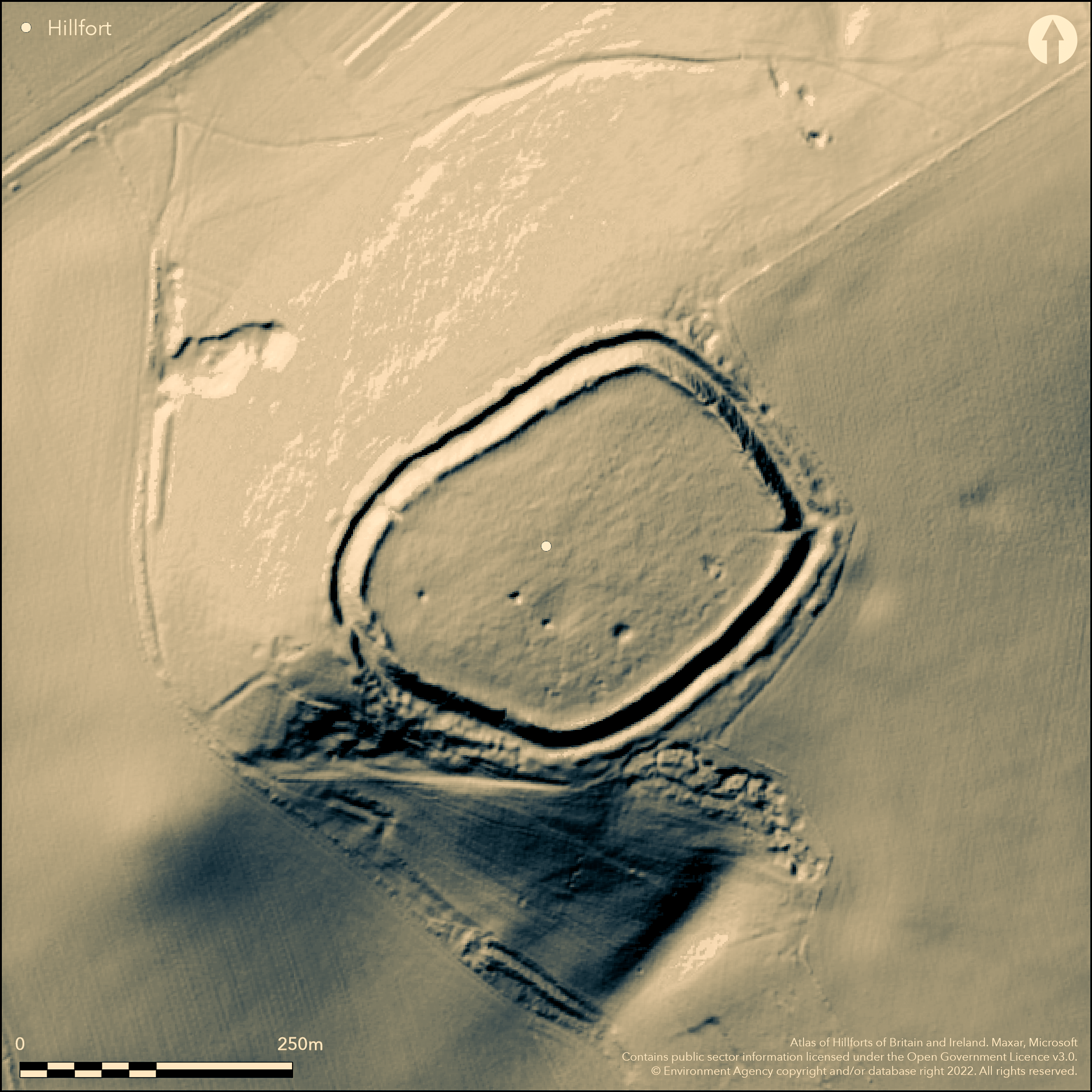
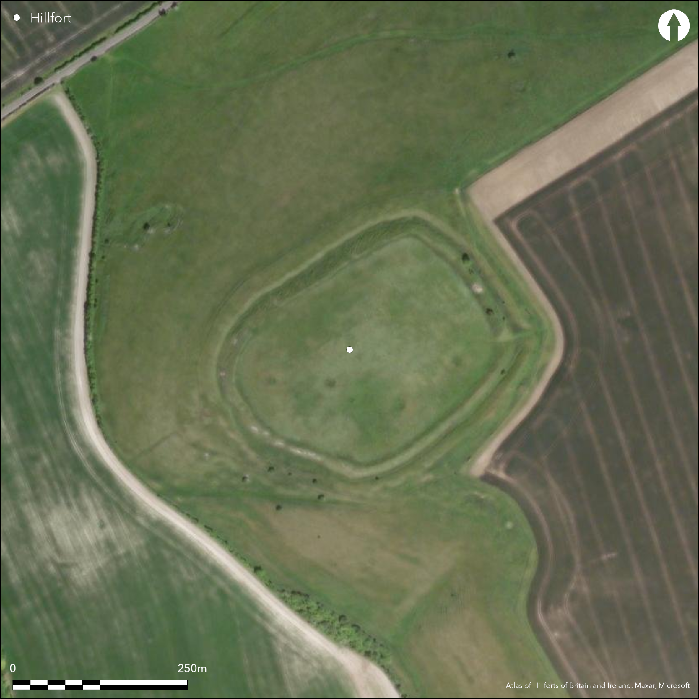
A fine, strategically sited, univallate, contour hillfort on N chalk downland scarp edge of Liddington Hill at N end of River Og valley enclosing 3ha. Extensive views to N and W across Thames Valley and S to Marlborough Downs. Opposite is Barbury Castle Atlas No 0387). Very exposed. Located at junction of linear ditch system. Roughly oval in plan, inner bank c. 12m across and up to 3m above flat interior. Fine surrounding ditch c. 18m across with very substantial counterscarp bank rising to 6m above ditch bottom and most prominent on N and W facing slopes. Rampart possibly faced with sarsens. Small-scale excavation 1976 showed rampart constructed in at least four phases, with the first c. 7th-8th centuries BC (though not securely dated) and last phase showed refortification in Saxon period (Hirst and Rahtz 1976). First rampart timber revetted at rear, succeeded by two phases of dump rampart, latter massive, of chalk rubble with front revetment of chalk sarsens. Excavation also yielded Romano-British and Roman-type 5th-6th AD century pottery with a few later sherds. During flint digging in NE interior, 1896-1900, Iron Age objects collected, including bronze awl, bronze earring, pottery, saddle quern fragments, spindle whorls, possible part of iron bucket. Also chance finds of Bronze Age, early Iron Age and Romano-British pottery. Simple causewayed entrance on SE. Possible W entrance blocked in antiquity and trackway across W ramparts was also noted in 18th century on Andrews and Dury's Topographical Map of Wiltshire 1773. Outer rampart and ditch damaged on S and SW, possibly through flint digging. Geophysical surveys showed possible large roundhouse feature and four large circular depressions in interior plus pits. Additional circular features, possibly wells, shafts or deep pits shown as sharp earthworks, but possibly military features of 18th/19th centuries. Possibly site of Battle of Mount Badon c. 500 AD, but no evidence from Hirst and Rahtz excavation. Linear features to W of fort and features to E and S possibly land divisions. Other, possible hillfort-type enclosures found nearby. Some slumping to rampart (some control), but good condition upland grassland. On 1st Ed OS map (1882).
Citizen Science: ✗
Reliability of Data: Confirmed
Reliability of Interpretation: Confirmed
X: -189316 Y: 6713050 (EPSG: 3857)
Longitude: -1.7006567839191047 Latitude: 51.5158272491522 (EPSG:4326)
Country: England
Current County or Unitary Authority: Wiltshire
Historic County: Wiltshire
Current Parish/Community/Council/Townland: Liddington
In fine condition despite some slumping of ramparts (some erosion control undertaken), earlier flint digging in interior and damage to S and SW rampart and ditch. On Heritage at Risk Register (2015).
| Extant | ✓ |
| Cropmark | ✗ |
| Likely Destroyed | ✗ |
Good upland pasture. Flint diggings.
| Woodland | ✗ |
| Commercial Forestry Plantation | ✗ |
| Parkland | ✗ |
| Pasture (Grazing) | ✓ |
| Arable | ✗ |
| Scrub/Bracken | ✗ |
| Bare Outcrop | ✗ |
| Heather/Moorland | ✗ |
| Heath | ✗ |
| Built-up | ✗ |
| Coastal Grassland | ✗ |
| Other | ✓ |
A fine, strategically sited chalk downland univallate contour hillfort on N scarp edge of Liddington Hill at N end of River Og valley opposite Barbury Castle. Extensive views to N and W across the Thames Valley and S to Marlborough Downs. Very exposed with steep slopes..
| Contour Fort | ✓ |
| Partial Contour Fort | ✗ |
| Promontory Fort | ✗ |
| Hillslope Fort | ✗ |
| Level Terrain Fort | ✗ |
| Marsh Fort | ✗ |
| Multiple Enclosure Fort | ✗ |
Located on a prominent spur of the Marlborough Downs at the northern end of the River Og valley, a major routeway. Just south of the ancient Ridgeway. Similar location to Barbury Castle.
| Hilltop | ✓ |
| Coastal Promontory | ✗ |
| Inland Promontory | ✗ |
| Valley Bottom | ✗ |
| Knoll/Hillock/Outcrop | ✗ |
| Ridge | ✗ |
| Cliff/Plateau-edge/Scarp | ✓ |
| Hillslope | ✗ |
| Lowland | ✗ |
| Spur | ✗ |
Dominant Topographic Feature: Downland plateau edge.
| North | ✗ |
| Northeast | ✗ |
| East | ✗ |
| Southeast | ✗ |
| South | ✗ |
| Southwest | ✗ |
| West | ✗ |
| Northwest | ✗ |
| Level | ✓ |
Altitude: 277.0m
N/A
Chance Iron Age finds. Small-scale excavations by Hirst and Rahtz (1976) have shown that the ramparts appear to have been constructed in at least four phases beginning in the late Bronze Age/Early Iron Age (7th-8th centuries BC), making it one of the earliest hillforts in Wiltshire. A second phase of the ramparts dated to the 5th century BC, provides evidence for long phase of occupation. Possible large timber building in interior of early Iron Age date. Last phase showed refortification in the Saxon period.
Reliability: B - Medium
| Pre 1200BC | ✗ |
| 1200BC - 800BC | ✗ |
| 800BC - 400BC | ✓ |
| 400BC - AD50 | ✓ |
| AD50 - AD400 | ✗ |
| AD400 - AD 800 | ✓ |
| Post AD800 | ✗ |
| Unknown | ✗ |
| Pre Hillfort: | None |
| Post Hillfort: | None |
| Artefactual: | Hirst and Rahtz (1996) |
On Andrews and Dury's Topographical Map of Wiltshire 1773. On Ist Ed. OS map (1882). Partly excavated by Hirst and Rahtz in 1976. Geophysical survey for Wessex Hillfort Project 1996. English Heritage carried out an earthwork survey in 2000 (M. Bowden). Management survey Wessex Archaeology 2000.
| 1st Identified Map Depiction (1773): | Andrews and Dury's Topographical Map of Wiltshire. |
| Other (1882): | OS map. |
| Excavation (1976): | Partly excavated by Hirst and Rahtz, Birmingham University. |
| Geophysical Survey (1996): | Wessex Hillforts Project. |
| Earthwork Survey (2000): | English Heritage measured survey Ridgeway Heritage Project (M. Bowden). |
| Other (2000): | Wessex Archaeology management survey. |
| Other (2003): | Visited by Hillfort Study Group |
Quarry scoop traces. Geophysical surveys showed large roundhouse and four large circular depressions in the interior plus a few pits. The excavation, yielded Romano-British and Roman-type 5th-6th AD century pottery with a few later sherds. During flint digging in the NE interior, 1896-1900, Iron Age objects collected including bronze awl, bronze ear-ring, pottery, saddle quern fragments, spindle whorls, possible part of iron bucket. Also chance finds of Bronze Age, early Iron Age and Romano-British pottery.
None
| None | ✓ |
| Spring | ✗ |
| Stream | ✗ |
| Pool | ✗ |
| Flush | ✗ |
| Well | ✗ |
| Other | ✗ |
Quarry scoop traces.
| No Known Features | ✗ |
| Round Stone Structures | ✗ |
| Rectangular Stone Structures | ✗ |
| Curvilinear Platforms | ✗ |
| Other Roundhouse Evidence | ✓ |
| Pits | ✗ |
| Quarry Hollows | ✓ |
| Other | ✓ |
Very partial excavation in interior. No evidence found for battle of Mount Badon.
| No Known Excavation | ✗ |
| Pits | ✗ |
| Postholes | ✗ |
| Roundhouses | ✗ |
| Rectangular Structures | ✗ |
| Roads/Tracks | ✗ |
| Quarry Hollows | ✗ |
| Other | ✗ |
| Nothing Found | ✓ |
Geophysical surveys showed very large roundhouse of c. 18m diameter and four large circular depressions in the interior, plus pits and curving ditches or gullies, with concentration on N and W parts of enclosure.
| No Known Geophysics | ✗ |
| Pits | ✓ |
| Roundhouses | ✓ |
| Rectangular Structures | ✗ |
| Roads/Tracks | ✗ |
| Quarry Hollows | ✗ |
| Other | ✓ |
| Nothing Found | ✗ |
The 1976 excavation, yielded Romano-British and Roman-type 5-6th AD century pottery with a few later sherds. During flint digging in the NE interior 1896-1900 chance finds of early Iron Age objects including bronze awl, bronze ear-ring, pottery, saddle quern fragments, spindle whorls, possible part of iron bucket. Also chance finds of Bronze Age, early Iron Age and Romano-British pottery.
| No Known Finds | ✗ |
| Pottery | ✓ |
| Metal | ✓ |
| Metalworking | ✗ |
| Human Bones | ✗ |
| Animal Bones | ✗ |
| Lithics | ✗ |
| Environmental | ✗ |
| Other | ✓ |
None
| APs Not Checked | ✓ |
| None | ✗ |
| Roundhouses | ✗ |
| Rectangular Structures | ✗ |
| Pits | ✗ |
| Postholes | ✗ |
| Roads/Tracks | ✗ |
| Other | ✗ |
Simple causewayed entrance on the SE side approximately 3m wide, where there are several sarsen stones visible at base of rampart terminals which may have been used to face the entrance. Blocked SW entrance visible as wide-topped section of rampart between two enlarged terminals. Several sarsen stones are visible at this point. Large blocks of chalk possibly part of the blocking. Shown on Andrews and Dury's Topographical Map of Wiltshire 1773.
| 1: | None |
| 2: | None |
Guard Chambers: ✗
Chevaux de Frise: ✗
| 1. Simple Gap (South east): | Causewayed. |
| 2. Blocked (South west): | Blocked SW entrance visible as wide-topped section of rampart between two enlarged terminals. |
Roughly oval in plan, inner bank c. 12m across and up to 3m above flat interior. Fine surrounding ditch c. 18m across with very substantial counterscarp bank rising to 6m above ditch bottom and most prominent on N and W facing slopes. Rampart possibly faced with sarsens.
| Area 1: | 3.0ha. |
| Total: | 3.0ha. |
Total Footprint Area: Noneha.
None
| ✓ | Small-scale excavation 1976 showed rampart constructed in at least four phases, with the first c. 7th-8th centuries BC (though not securely dated) and the the last phase showed refortification in the Saxon period. |
| ✓ | None |
| NE Quadrant: | 1 |
| SE Quadrant: | 1 |
| SW Quadrant: | 1 |
| NW Quadrant: | 1 |
| Total: | 1 |
| Partial Univallate | ✗ |
| Univallate | ✓ |
| Partial Bivallate | ✗ |
| Bivallate | ✗ |
| Partial Multivallate | ✗ |
| Multivallate | ✗ |
| Unknown | ✗ |
| Partial Univallate | ✗ |
| Univallate | ✗ |
| Partial Bivallate | ✗ |
| Bivallate | ✗ |
| Partial Multivallate | ✗ |
| Multivallate | ✗ |
Bank of chalk rubble and substantial counterscarp bank. Possible sarsen stone facing.
| None | ✗ |
| Earthen Bank | ✓ |
| Stone Wall | ✓ |
| Rubble | ✓ |
| Wall-walk | ✗ |
| Evidence of Timber | ✗ |
| Vitrification | ✗ |
| Other Burning | ✗ |
| Palisade | ✗ |
| Counter Scarp Bank | ✓ |
| Berm | ✗ |
| Unfinished | ✗ |
| Other | ✗ |
Small-scale excavation 1976 showed rampart constructed in at least four phases, with the first c. 7th-8th centuries BC (though not securely dated) and the the last phase showed refortification in the Saxon period. First rampart timber revetted at rear, succeeded by two phases of dump rampart, latter massive, of chalk rubble with front revetment of chalk sarsens. Possible ditch or palisade trench also recorded c. 13m inside inner rampart to 1m wide
| None | ✗ |
| Earthen Bank | ✓ |
| Stone Wall | ✓ |
| Murus Duplex | ✗ |
| Timber-framed | ✗ |
| Timber-laced | ✗ |
| Vitrification | ✗ |
| Other Burning | ✗ |
| Palisade | ✓ |
| Counter Scarp Bank | ✓ |
| Berm | ✗ |
| Unfinished | ✗ |
| No Known Excavation | ✗ |
| Other | ✗ |
| ✓ | Possible evidence. Rampart constructed in short, straight lengths, with marked changes of alignment (Payne at al 2006, 112). |
| ✓ | Fine ditch surrounds site with substantial counterscarp bank. |
Number of Ditches: 1
| ✗ | None |
Bowden, M. 2000. Liddington Castle: archaeological earthwork survey (version 2). EH survey report no. AI/4/2001.
Bowden M. 2005. The middle Iron Age on the Marlborough Downs, in eds G. Brown, D. Field and D. McOmish, The Avebury landscape, Oxford: Oxbow Books, 156-63.
Brown, I. 2009. Beacons in the landscape. The hillforts of England and Wales, Oxford: Windgather Press/Oxbow Books.
Hirst, S. and Rahtz, P. 1996. Liddington Castle and the Battle of Badon: excavation and research 1976, Archaeol J, 153, 1-59.
Payne, A., Corney, M. and Cunliffe, B. 2006. The Wessex Hillforts Project. Extensive survey of hillfort interiors in Cenral Southern England, London: English Heritage, 111-118.
Pugh, R.B. and Crittall, E. 1957. A history of Wiltshire, 1.1, The Victoria History of the Counties of England, London: OUP, 82, 267.
Atlas of Hillforts:
Wikidata:
This work is licensed under CC BY-SA 4.0![]()
![]()
![]() and should be cited as:
and should be cited as:
Lock, Gary and Ralston, Ian. 2024. Atlas of Hillforts of Britain and Ireland. Available at: https://hillforts.arch.ox.ac.uk
Document Version 1.1