LiDAR 1m DTM Hillshade

Satellite Imagery
LiDAR 1m DTM Hillshade
Satellite Imagery
Scroll left/right to view further images.
HER: Wiltshire and Swindon MWI6162 (None)
NMR: SU 03 NW 21 (214511)
SM: 1005604
NGR: SU04833579
X: 404830 Y: 135790 (OSGB36)
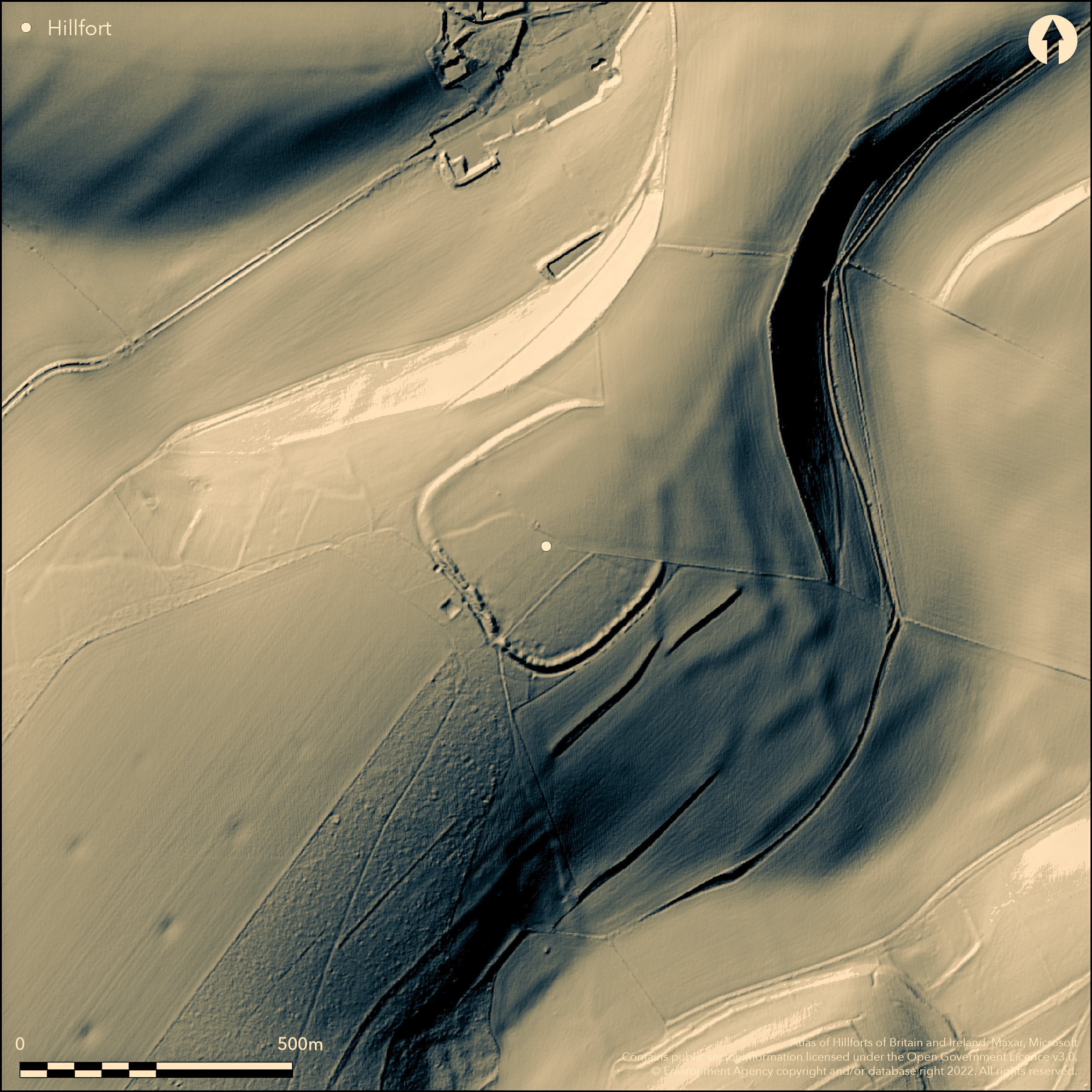
The remains of large, complex, hillslope fort enclosing c. 5.3ha located at the NE end of spur of Farm Down within extensive prehistoric and Romano-British downland settlements sited on Grovely Great Ridge and opposite Ebsbury hillfort. Once defended by triple line of ramparts, now univallate, only single rampart surviving. S half of the defences consists of rampart and external ditch, but on N much reduced by ploughing. Rampart rises to 3.2m above bottom of outer ditch 1.5m deep in W, but only seen on APs in N and E. To S and SE rampart constructed as series of dumps of material giving unfinished appearance. Ditch external with counterscarp bank running for c. 35m S of SW entrance. Internal quarry scoops located immediately within the rampart, best seen to S. Possible SW and NE entrances, but ploughing of latter reduced rampart to scarp, obscuring detail. In interior near quarry scoops circular/sub-circular hollows possibly building platforms. APs show possible circular enclosure c. 35m-40m diameter. Five human skeletons deposited in chalk filling of rampart at time built with early Iron Age sherd found in excavations by Collins and Ewance 1950 . Late Iron Age sherd found on ploughed land at the edge of the hillfort. Bank and ditch, passing through the hillfort and overlying and post-dating main enclosure, probably part of extensive surrounding 'Celtic' field system. To E, W, S and SE, banks of this field system overlying rampart accounts for irregular mutilations along length. Fragments of field system to W of hillfort continue into site, possibly contiguous, but lynchet running from NW apex and likely part of this system, cuts into rampart and therefore possibly later. Within interior another bank and ditch running E from SW entrance possibly former woodland or field boundary and post-dates hillfort. Site farmed for many years. On Ist Ed. OS map (1887).
Citizen Science: ✗
Reliability of Data: Confirmed
Reliability of Interpretation: Confirmed
X: -215112 Y: 6642782 (EPSG: 3857)
Longitude: -1.9323847213735033 Latitude: 51.12131800824124 (EPSG:4326)
Country: England; None
Current County or Unitary Authority: Wiltshire
Historic County: Wiltshire
Current Parish/Community/Council/Townland: Steeple Langford; Barford St Martin; Great Wishford
Much damaged. Only one of former three ramparts surviving. Farmed for many years.
| Extant | ✓ |
| Cropmark | ✓ |
| Likely Destroyed | ✗ |
Farmed.
| Woodland | ✗ |
| Commercial Forestry Plantation | ✗ |
| Parkland | ✗ |
| Pasture (Grazing) | ✓ |
| Arable | ✓ |
| Scrub/Bracken | ✗ |
| Bare Outcrop | ✗ |
| Heather/Moorland | ✗ |
| Heath | ✗ |
| Built-up | ✗ |
| Coastal Grassland | ✗ |
| Other | ✗ |
Remains of large hillslope fort located at the NE end of downland spur of Farm Down.
| Contour Fort | ✗ |
| Partial Contour Fort | ✗ |
| Promontory Fort | ✗ |
| Hillslope Fort | ✓ |
| Level Terrain Fort | ✗ |
| Marsh Fort | ✗ |
| Multiple Enclosure Fort | ✗ |
Situated on a prominent north-eastern spur slope above the River Wylye valley.
| Hilltop | ✗ |
| Coastal Promontory | ✗ |
| Inland Promontory | ✗ |
| Valley Bottom | ✗ |
| Knoll/Hillock/Outcrop | ✗ |
| Ridge | ✗ |
| Cliff/Plateau-edge/Scarp | ✗ |
| Hillslope | ✓ |
| Lowland | ✗ |
| Spur | ✓ |
Dominant Topographic Feature: Downland promontory spur
| North | ✗ |
| Northeast | ✓ |
| East | ✗ |
| Southeast | ✗ |
| South | ✗ |
| Southwest | ✗ |
| West | ✗ |
| Northwest | ✗ |
| Level | ✗ |
Altitude: 152.0m
Three parishes on site.
Boundary Type: Parish/Townland
Early Iron Age sherd found in excavations by Collins and Ewance 1950 . Late Iron Age sherd found on ploughed land at the edge of the hillfort.
Reliability: C - Low
| Pre 1200BC | ✗ |
| 1200BC - 800BC | ✗ |
| 800BC - 400BC | ✓ |
| 400BC - AD50 | ✓ |
| AD50 - AD400 | ✗ |
| AD400 - AD 800 | ✗ |
| Post AD800 | ✗ |
| Unknown | ✗ |
| Pre Hillfort: | None |
| Post Hillfort: | None |
In Aubrey's Monumenta Britannica (1665-1693). On Ist Ed. OS map (1887). Excavation W. Cunnington Sen. 1800-10. Excavation V.M. Collins 1950. Partial excavation 1974 - no details. Measured survey RCHME South Wiltshire Project, ref. no. 831573.
| 1st Identified Map Depiction (1887): | OS map. |
| Excavation (1950): | V.M. Collins - no report. |
| Excavation (1974): | Partial excavation - no details. |
| Excavation (1974): | No details. |
| Other (1984): | Visited by Hillfort Study Group |
| 1st Identified Written Reference (None): | In Aubrey's Monumenta Britannica. |
| Earthwork Survey (None): | Measured survey RCHME. |
Rampart only seen on APs in N and E. Internal quarry scoops located immediately within the rampart, best seen to S. Possible building platforms. Field system and boundary banks. Five human skeletons deposited in chalk filling of rampart when built at time rampart built found by P.F. Ewence with early Iron Age sherd. Late Iron Age sherd found by R.S. Newall on ploughed land at the edge of hillfort.
Dew-pond c.16 sq m area 10m to W of the hillfort. Surrounded by low bank.
| None | ✓ |
| Spring | ✗ |
| Stream | ✗ |
| Pool | ✗ |
| Flush | ✗ |
| Well | ✗ |
| Other | ✗ |
Internal quarry scoop located immediately within the rampart, best seen to S. Possible building platforms. Field system and boundary banks.
| No Known Features | ✗ |
| Round Stone Structures | ✗ |
| Rectangular Stone Structures | ✗ |
| Curvilinear Platforms | ✓ |
| Other Roundhouse Evidence | ✗ |
| Pits | ✗ |
| Quarry Hollows | ✓ |
| Other | ✓ |
None
| No Known Excavation | ✓ |
| Pits | ✗ |
| Postholes | ✗ |
| Roundhouses | ✗ |
| Rectangular Structures | ✗ |
| Roads/Tracks | ✗ |
| Quarry Hollows | ✗ |
| Other | ✗ |
| Nothing Found | ✗ |
None
| No Known Geophysics | ✓ |
| Pits | ✗ |
| Roundhouses | ✗ |
| Rectangular Structures | ✗ |
| Roads/Tracks | ✗ |
| Quarry Hollows | ✗ |
| Other | ✗ |
| Nothing Found | ✗ |
Five human skeletons deposited in chalk filling of rampart when built at time rampart built found by Collins and Ewence with early Iron Age sherd. Late Iron Age sherd found on ploughed land at the edge of the hillfort.
| No Known Finds | ✗ |
| Pottery | ✓ |
| Metal | ✗ |
| Metalworking | ✗ |
| Human Bones | ✓ |
| Animal Bones | ✗ |
| Lithics | ✗ |
| Environmental | ✗ |
| Other | ✗ |
Rampart only seen on APs in N and E.
| APs Not Checked | ✗ |
| None | ✗ |
| Roundhouses | ✗ |
| Rectangular Structures | ✗ |
| Pits | ✗ |
| Postholes | ✗ |
| Roads/Tracks | ✗ |
| Other | ✓ |
Possible SW and NE entrances, but ploughing of latter reduced rampart to scarp, obscuring detail.
| 2: | None |
| 2: | None |
Guard Chambers: ✗
Chevaux de Frise: ✗
| 1. Simple Gap (South west): | None |
| 2. Simple Gap (North east): | Ploughing masks detail. |
Once defended by triple line of ramparts, now univallate, only single rampart surviving. S half of the defences consists of rampart and external ditch, but on N much reduced by ploughing. Rampart rises to 3.2m above bottom of outer ditch 1.5m deep in W, but only seen on APs in N and E. To S and SE rampart constructed as series of dumps of material giving an unfinished appearance. The ditch external with counterscarp bank running for c. 35m S of SW entrance. Internal quarry scoop located immediately within the rampart, best seen to S.
| Area 1: | 5.3ha. |
| Total: | 5.3ha. |
Total Footprint Area: Noneha.
None
| ✗ | None |
| ✓ | None |
| NE Quadrant: | 1 |
| SE Quadrant: | 1 |
| SW Quadrant: | 1 |
| NW Quadrant: | 1 |
| Total: | 1 |
| Partial Univallate | ✗ |
| Univallate | ✓ |
| Partial Bivallate | ✗ |
| Bivallate | ✗ |
| Partial Multivallate | ✗ |
| Multivallate | ✗ |
| Unknown | ✗ |
| Partial Univallate | ✗ |
| Univallate | ✗ |
| Partial Bivallate | ✗ |
| Bivallate | ✗ |
| Partial Multivallate | ✗ |
| Multivallate | ✗ |
To S and SE rampart constructed as series of dumps of material giving an unfinished appearance.
| None | ✗ |
| Earthen Bank | ✓ |
| Stone Wall | ✗ |
| Rubble | ✗ |
| Wall-walk | ✗ |
| Evidence of Timber | ✗ |
| Vitrification | ✗ |
| Other Burning | ✗ |
| Palisade | ✗ |
| Counter Scarp Bank | ✓ |
| Berm | ✗ |
| Unfinished | ✓ |
| Other | ✗ |
None
| None | ✗ |
| Earthen Bank | ✗ |
| Stone Wall | ✗ |
| Murus Duplex | ✗ |
| Timber-framed | ✗ |
| Timber-laced | ✗ |
| Vitrification | ✗ |
| Other Burning | ✗ |
| Palisade | ✗ |
| Counter Scarp Bank | ✗ |
| Berm | ✗ |
| Unfinished | ✗ |
| No Known Excavation | ✓ |
| Other | ✗ |
| ✗ | None |
| ✓ | None |
Number of Ditches: 1
| ✗ | None |
Colt Hoare, R.C. 1810. The Ancient History of Wiltshire, 1, London: Miller, 111.
Geophysical Surveys of Bradford 1989. Report on Geophysical Survey: Longbridge Deverill, Grovely Castle, Parsonage Down & Hamshill, Wiltshire/Spring 1989, Geophysical Surveys of Bradford Reports.
Pugh, R.B. and Crittall, E. 1957. A history of Wiltshire, 1.1, The Victoria History of the Counties of England, London: OUP, 208.
Atlas of Hillforts:
Wikidata:
This work is licensed under CC BY-SA 4.0![]()
![]()
![]() and should be cited as:
and should be cited as:
Lock, Gary and Ralston, Ian. 2024. Atlas of Hillforts of Britain and Ireland. Available at: https://hillforts.arch.ox.ac.uk
Document Version 1.1