LiDAR 1m DTM Hillshade
Satellite Imagery
LiDAR 1m DTM Hillshade
Satellite Imagery
Scroll left/right to view further images.
HER: Wiltshire MWI7222 (None)
NMR: SU 04 SW 6 (215137)
SM: 1005689
NGR: SU03524039
X: 403526 Y: 140392 (OSGB36)
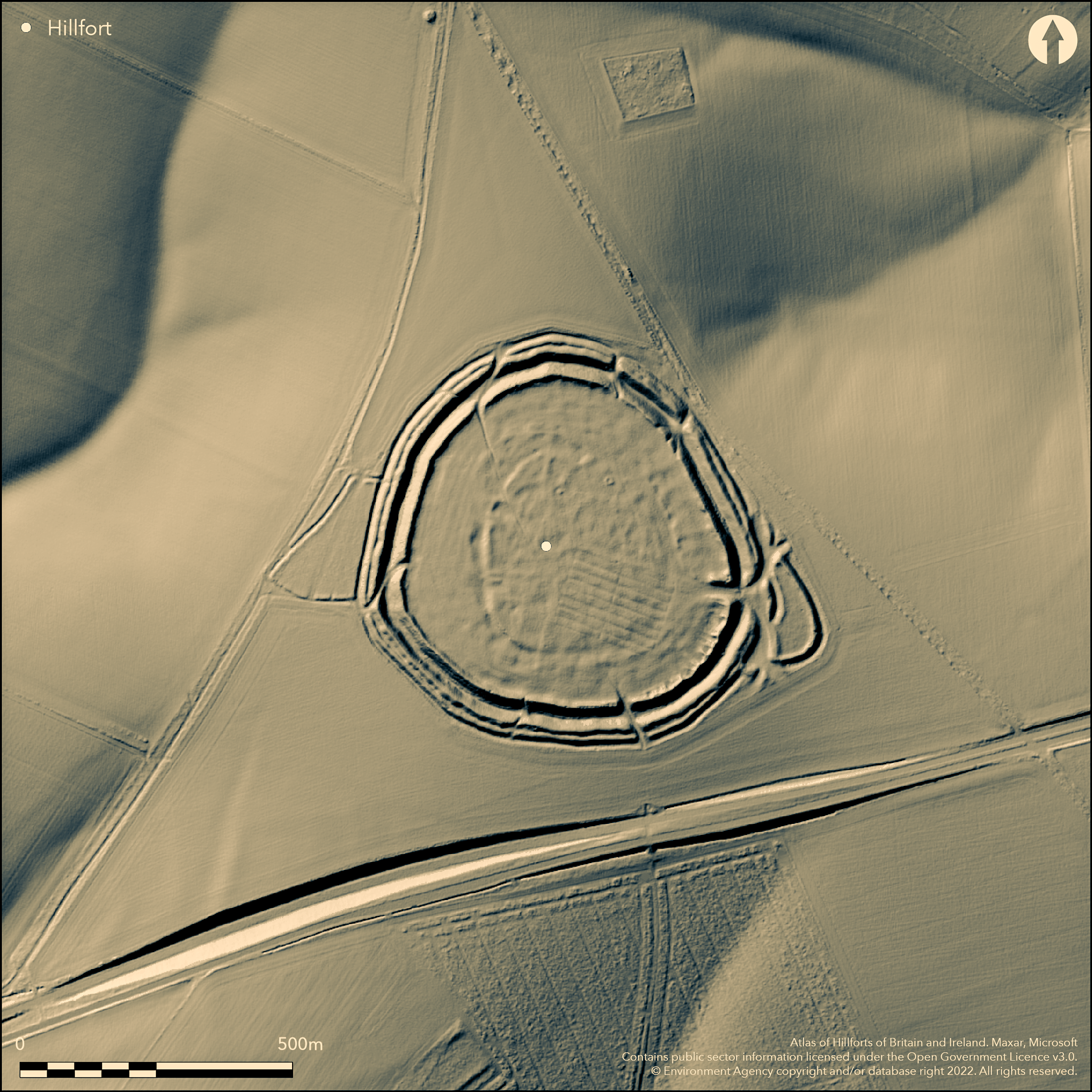
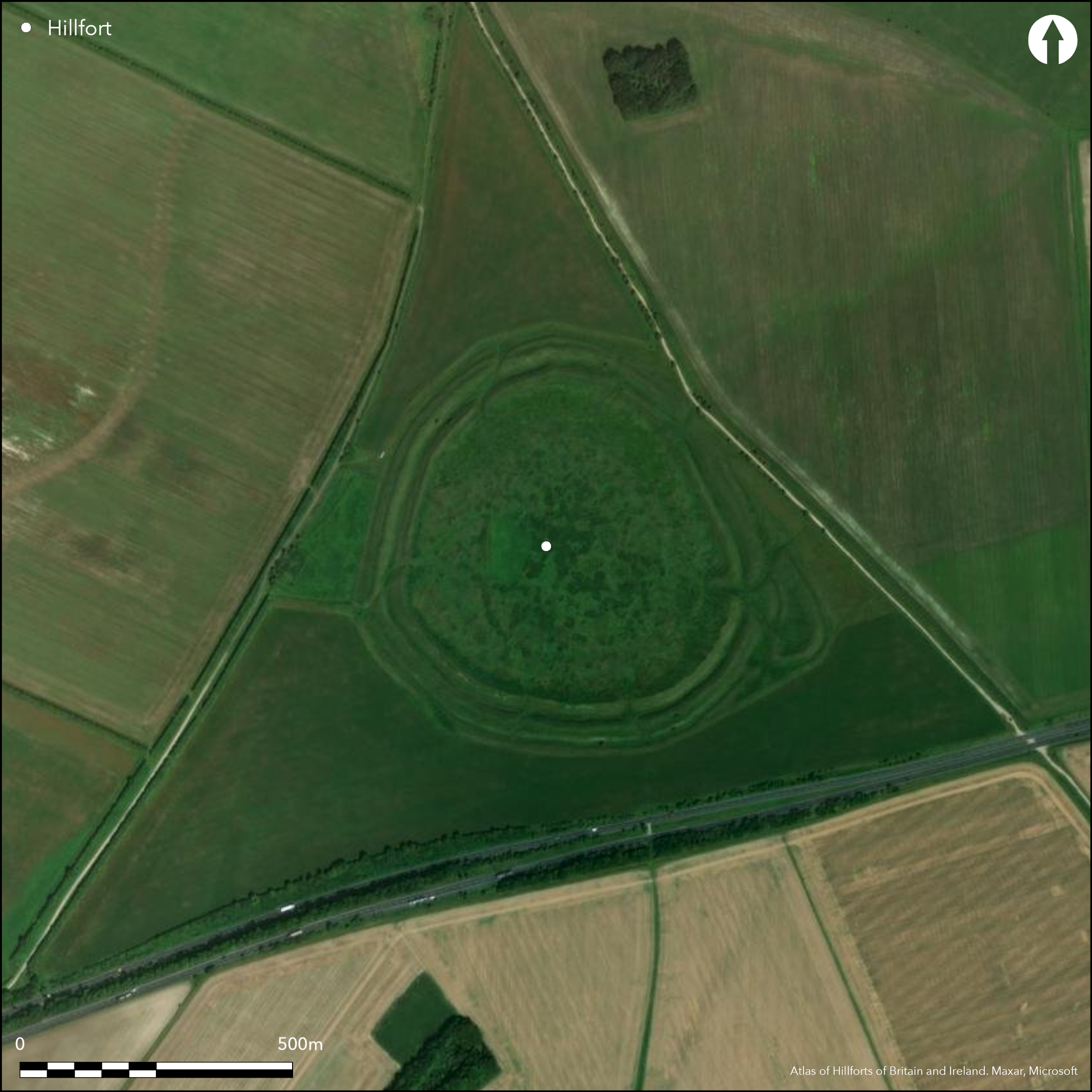
Large, multiphase and complex, multivallate, contour hillfort enclosing 11ha located on prominent Upper Chalk downland spur of Berwick Down above Wylye Valley 3km to SW, with access to river via dry valley S of Deptford Down. Circuit comprises three earthen ramparts with outer ditches, although outer ditch absent on NE as result of later downland drove way. Overall width of defences c. 20m. Outer rampart, up to 3.5m high above the 1.7m deep ditch, encroached upon by median rampart in places, suggesting that this and inner rampart were either constructed or enlarged later. In places berm at original ground surface level survives between middle and outer banks, and this and irregular quarry ditch along the inside of inner rampart, further evidence of alterations to original plan. Within hillfort interior is earlier enclosure of 5.2ha best preserved on W and SW. The marked 'causewayed' effect of ditch due Iron Age and Romano-British structures date into the feature, making use of shelter. On the NW ditch modified by track leading from entrance, and serving compounds and structures of later phase. Entrance into inner enclosure sited on W side and flanked by two low mounds which may be the remains of spoil heaps associated with Cunnington's excavations. Small enclosure outside ramparts on W probably late Romano-British stock enclosure. Quarry scoops behind inner rampart for most of circuit. Marked hollows in ditch bottoms, often reflected by 'dumps' on rampart crests suggest 'gang' working, as also do the straight rampart lengths. Of the seven breaches in the circuit, only those on N and E, and possibly on W, can be considered original, rest later and some possibly associated with Romano-British occupation or post medieval drove ways. Great intensity of occupation with over 130 probable structures surviving mainly as hollows up to 1m deep. Majority circular, 7m to 15m diameter, many being set within compounds or yards. On N and E, between earlier circuit and inner rampart, large compounds containing structures visible, with possible stone footings visible within many. Not all of these structures likely contemporary. Within a number of them indications of overlapping elements. Also pits, probably contemporary with the occupation, visible. In SE remains of Winterbourne Stoke sheep fair held biannually until 1916, when surrounding area commandeered by the army. Prominent sheep folds visible. Site excavated by Colt Hoare (1812) and Maud Cunnington (1933). On 1st Ed OS map (1887-8).
Citizen Science: ✗
Reliability of Data: Confirmed
Reliability of Interpretation: Confirmed
X: -217181 Y: 6650126 (EPSG: 3857)
Longitude: -1.9509729172523707 Latitude: 51.162709399231474 (EPSG:4326)
Country: England; None
Current County or Unitary Authority: Wiltshire
Historic County: Wiltshire
Current Parish/Community/Council/Townland: Steeple Langford; Berwick St James
General good condition apart from some quarrying on inner SE rampart. Numerous banks and scoops in interior result of annual sheep fairs from 18th century to 1916. SSSI.
| Extant | ✓ |
| Cropmark | ✗ |
| Likely Destroyed | ✗ |
Downland pasture. Quarrying.
| Woodland | ✗ |
| Commercial Forestry Plantation | ✗ |
| Parkland | ✗ |
| Pasture (Grazing) | ✓ |
| Arable | ✗ |
| Scrub/Bracken | ✗ |
| Bare Outcrop | ✗ |
| Heather/Moorland | ✗ |
| Heath | ✗ |
| Built-up | ✗ |
| Coastal Grassland | ✗ |
| Other | ✓ |
Large, multiphase, multivallate contour hillfort enclosing 11ha located on prominent Upper Chalk downland spur ridge of Berwick Down above Wylye Valley 3km to SW, with access to river via dry valley S of Deptford Down.
| Contour Fort | ✓ |
| Partial Contour Fort | ✗ |
| Promontory Fort | ✗ |
| Hillslope Fort | ✗ |
| Level Terrain Fort | ✗ |
| Marsh Fort | ✗ |
| Multiple Enclosure Fort | ✗ |
Important and large hillfort strategically sited on prominent and high downland spur above the River Wylye valley, and above Berwick Down to the north-east. Bilbury Rings and Grovely Castle hillforts sited on opposite side of the valley.
| Hilltop | ✗ |
| Coastal Promontory | ✗ |
| Inland Promontory | ✗ |
| Valley Bottom | ✗ |
| Knoll/Hillock/Outcrop | ✗ |
| Ridge | ✓ |
| Cliff/Plateau-edge/Scarp | ✗ |
| Hillslope | ✗ |
| Lowland | ✗ |
| Spur | ✓ |
Dominant Topographic Feature: Prominent downland spur ridge.
| North | ✗ |
| Northeast | ✗ |
| East | ✗ |
| Southeast | ✗ |
| South | ✗ |
| Southwest | ✗ |
| West | ✗ |
| Northwest | ✗ |
| Level | ✓ |
Altitude: 167.0m
Boundary Type: Parish/Townland
Dated to 100 BC, with a small internal enclosure dated to 300 BC as result of pottery.
Reliability: B - Medium
| Pre 1200BC | ✗ |
| 1200BC - 800BC | ✗ |
| 800BC - 400BC | ✗ |
| 400BC - AD50 | ✓ |
| AD50 - AD400 | ✓ |
| AD400 - AD 800 | ✗ |
| Post AD800 | ✗ |
| Unknown | ✗ |
| Pre Hillfort: | None |
| Post Hillfort: | None |
| Artefactual: | Dated to 100 BC, with a small internal enclosure dated to 300 BC. |
In Aubrey's Monumenta Britannica (1665-1693). On 1st Ed OS map (1887-8). Excavated 1800-10 by W.Cunnington Sen. and June 1932 by B.H. and M.E. Cunnington. Geophysical surveys by Geophysical Surveys of Bradford on behalf of RCHME in 1987.
| Excavation (1932): | B.H. and M.E. Cunnington |
| Other (1984): | Visited by Hillfort Study Group |
| Geophysical Survey (1987): | Surveyed by Geophysical Surveys of Bradford on behalf of RCHME. |
| 1st Identified Written Reference (None): | In Aubrey's Monumenta Britannica. |
| Excavation (None): | W. Cunnington Sen. |
| 1st Identified Map Depiction (None): | OS map. |
Great intensity of occupation with over 130 probable structures surviving mainly as hollows up to 1m deep. Majority circular, 7m to 15m diameter, many being set within compounds or yards. On N and E, between earlier circuit and inner rampart, large compounds containing structures visible, with possible stone footings visible within many. Not all of these structures likely contemporary. Within a number of them indications of overlapping elements. Also pits, probably contemporary with the occupation, visible. Excavations have recovered Iron Age and Roman pottery, as well as inhumations in both graves and pits, and other human remains. Iron Age and Roman coins were also found. Roman material, including pottery, tiles, coins and burials from excavation and chance finds led to site's inclusion in Scott's gazetteer of Roman villas.
None
| None | ✓ |
| Spring | ✗ |
| Stream | ✗ |
| Pool | ✗ |
| Flush | ✗ |
| Well | ✗ |
| Other | ✗ |
Great intensity of occupation with over 130 probable structures surviving mainly as hollows up to 1m deep. Majority circular, 7m to 15m diameter, many being set within compounds or yards. On N and E, between earlier circuit and inner rampart, large compounds containing structures visible, with possible stone footings visible within many. Not all of these structures likely contemporary. Within a number of them indications of overlapping elements. Also pits, probably contemporary with the occupation, visible. Prominent sheep folds visible, a rectangular area 120m by 90m and consisting of 16 low mounds in two blocks of 8. The present sheep fold probably 19th century. Quarry scoops behind inner rampart for most of circuit.
| No Known Features | ✗ |
| Round Stone Structures | ✗ |
| Rectangular Stone Structures | ✗ |
| Curvilinear Platforms | ✗ |
| Other Roundhouse Evidence | ✓ |
| Pits | ✓ |
| Quarry Hollows | ✓ |
| Other | ✓ |
Pits.
| No Known Excavation | ✗ |
| Pits | ✓ |
| Postholes | ✗ |
| Roundhouses | ✗ |
| Rectangular Structures | ✗ |
| Roads/Tracks | ✗ |
| Quarry Hollows | ✗ |
| Other | ✗ |
| Nothing Found | ✗ |
Pits.
| No Known Geophysics | ✗ |
| Pits | ✓ |
| Roundhouses | ✗ |
| Rectangular Structures | ✗ |
| Roads/Tracks | ✗ |
| Quarry Hollows | ✗ |
| Other | ✗ |
| Nothing Found | ✗ |
Excavations have recovered Iron Age and Roman pottery, as well as inhumations in both graves and pits, and other human remains. Iron Age and Roman coins were also found. Roman material, including pottery, tiles, coins and burials from excavation and chance finds led to site's inclusion in Scott's gazetteer of Roman villas.
| No Known Finds | ✗ |
| Pottery | ✓ |
| Metal | ✗ |
| Metalworking | ✗ |
| Human Bones | ✓ |
| Animal Bones | ✗ |
| Lithics | ✗ |
| Environmental | ✗ |
| Other | ✓ |
None
| APs Not Checked | ✓ |
| None | ✗ |
| Roundhouses | ✗ |
| Rectangular Structures | ✗ |
| Pits | ✗ |
| Postholes | ✗ |
| Roads/Tracks | ✗ |
| Other | ✗ |
Of the seven breaches in the defensive circuit, only those on N and E possibly original, rest of later date, some possibly associated with Romano-British occupation, although break in W may have been made to give access to later sub-rectangular enclosure on that side. Elaborate and complex inturned entrance on E and offset entrance on N.
| 7: | Of the seven breaches in the defensive circuit, only those on N and E possibly original, rest of later date, some possibly associated with Romano-British occupation. |
| 2: | Main entrances on N and E. Break in the W may have been made to give access to the later sub-rectangular enclosure on that side. |
Guard Chambers: ✗
Chevaux de Frise: ✗
| 1. In-turned (East): | Elaborate and complex. |
| 2. Oblique (North): | Oblique entrance. |
| 3. Simple Gap (West): | Break in the W may have been made to give access to the later sub-rectangular enclosure on that side. |
Circuit comprises three ramparts with outer ditches, although outer ditch absent on NE as result of later downland drove way. Overall width of defences c. 20m. Outer rampart, up to 3.5m high above the 1.7m deep ditch, encroached upon by median rampart in places, suggesting that this and inner rampart were either constructed or enlarged later. In places berm at original ground surface level survives between middle and outer banks, and this and irregular quarry ditch along the inside of inner rampart, further evidence of alterations to original plan.
| Area 1: | 5.2ha. |
| Area 2: | 11.0ha. |
| Total: | 11.0ha. |
Total Footprint Area: Noneha.
None
| ✓ | Outer rampart, up to 3.5m high above the 1.7m deep ditch, encroached upon by median rampart in places, suggesting that this and inner rampart were either constructed or enlarged later. |
| ✓ | None |
| NE Quadrant: | 2 |
| SE Quadrant: | 3 |
| SW Quadrant: | 3 |
| NW Quadrant: | 3 |
| Total: | 3 |
| Partial Univallate | ✗ |
| Univallate | ✗ |
| Partial Bivallate | ✓ |
| Bivallate | ✗ |
| Partial Multivallate | ✓ |
| Multivallate | ✗ |
| Unknown | ✗ |
| Partial Univallate | ✗ |
| Univallate | ✓ |
| Partial Bivallate | ✗ |
| Bivallate | ✗ |
| Partial Multivallate | ✗ |
| Multivallate | ✗ |
None
| None | ✗ |
| Earthen Bank | ✓ |
| Stone Wall | ✗ |
| Rubble | ✗ |
| Wall-walk | ✗ |
| Evidence of Timber | ✗ |
| Vitrification | ✗ |
| Other Burning | ✗ |
| Palisade | ✗ |
| Counter Scarp Bank | ✗ |
| Berm | ✓ |
| Unfinished | ✗ |
| Other | ✗ |
None
| None | ✗ |
| Earthen Bank | ✓ |
| Stone Wall | ✗ |
| Murus Duplex | ✗ |
| Timber-framed | ✗ |
| Timber-laced | ✗ |
| Vitrification | ✗ |
| Other Burning | ✗ |
| Palisade | ✗ |
| Counter Scarp Bank | ✗ |
| Berm | ✗ |
| Unfinished | ✗ |
| No Known Excavation | ✗ |
| Other | ✗ |
| ✓ | Marked hollows in ditch bottoms, often reflected by 'dumps' on rampart crests, suggest 'gang' working, as also do the straight rampart lengths. |
| ✓ | Outer ditch absent on NE as result of later downland drove way. |
Number of Ditches: 3
| ✗ | None |
Pugh, R.B. and Crittall, E. 1957. A history of Wiltshire, 1.1, The Victoria History of the Counties of England, London: OUP, 1.2, 430.
Cunnington, M.E. 1933. Yarnbury, Wiltshire, Wiltshire Archaeol Natur Hist Mag, 46, 198-217.
Geophysical Surveys of Bradford 1987. Report on Geophysical Survey: Yarnbury Castle, Wiltshire/Spring 1987,Geophysical Surveys of Bradford/Reports.
Colt Hoare, R.C. 1812. The ancient history of Wiltshire, I, London: Miller.
Atlas of Hillforts:
Wikidata:
This work is licensed under CC BY-SA 4.0![]()
![]()
![]() and should be cited as:
and should be cited as:
Lock, Gary and Ralston, Ian. 2024. Atlas of Hillforts of Britain and Ireland. Available at: https://hillforts.arch.ox.ac.uk
Document Version 1.1