LiDAR 1m DTM Hillshade
Satellite Imagery
LiDAR 1m DTM Hillshade
Satellite Imagery
Scroll left/right to view further images.
HER: Wiltshire and Swindon MWI9893 (None)
NMR: SU 12 NW 3 (217694)
SM: 1004775
NGR: SU14462517
X: 414463 Y: 125173 (OSGB36)
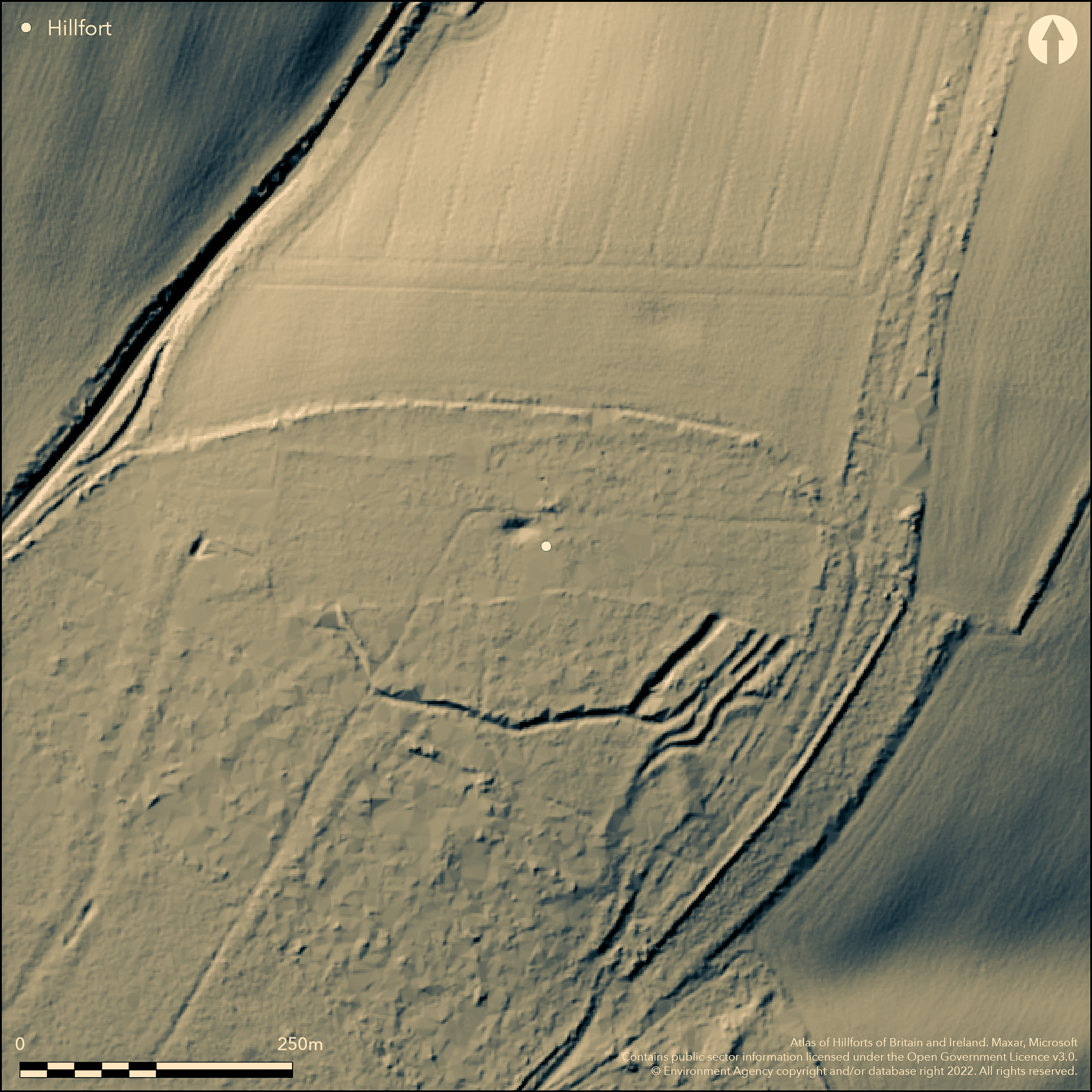
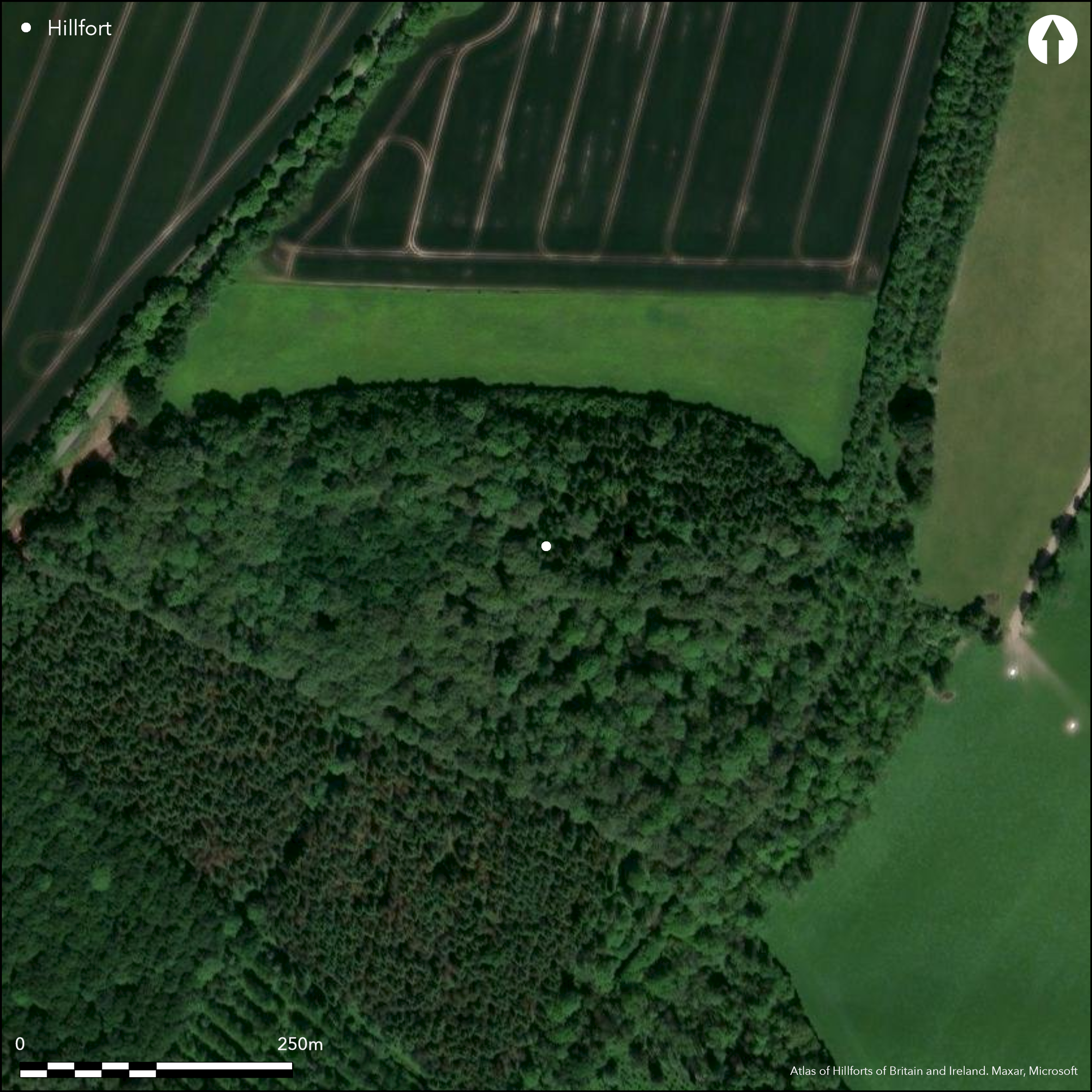
Wooded, polygonal-shaped, hillfort sited on N-facing downland spur edge at 110m O.D. overlooking the Ebble Valley to N and confluence of River Ebble with River Avon, just S of Salisbury. Bank stands c. 0.9m high internally and to 2.3m above external ditch. Polygonal shaped with sides c. 70m in length, enclosing 4ha. Two additional banks with ditches to E - relationship to other banks and function unknown. They could be hollow ways, remnants of a multivallation attempt or a more lightly defended late Iron Age settlement. Immediately to E broad level area or berm associated with bank and external ditch. This second ditch curves to meet that associated with the polygon and appears to cut through course of latter; however both constructions appear parts of same system. N part ploughed away before 1894. Earthworks now lie in plantations and coppiced woodlands and light coppice bank extends across site. Possible annexe to SE and ditches E of annexe fade on flat ground. The single gap towards the W end may not be original. Few investigations, no dating evidence. On Ist Ed. OS map (1871-81).
Citizen Science: ✗
Reliability of Data: Confirmed
Reliability of Interpretation: Confirmed
X: -199837 Y: 6625839 (EPSG: 3857)
Longitude: -1.7951675001020966 Latitude: 51.02568670095302 (EPSG:4326)
Country: England
Current County or Unitary Authority: Wiltshire
Historic County: Wiltshire
Current Parish/Community/Council/Townland: Odstock
N part ploughed away before 1894.
| Extant | ✓ |
| Cropmark | ✗ |
| Likely Destroyed | ✗ |
Earthworks now lie in plantations and coppiced woodlands and light coppice bank extends across site.
| Woodland | ✓ |
| Commercial Forestry Plantation | ✓ |
| Parkland | ✗ |
| Pasture (Grazing) | ✗ |
| Arable | ✗ |
| Scrub/Bracken | ✗ |
| Bare Outcrop | ✗ |
| Heather/Moorland | ✗ |
| Heath | ✗ |
| Built-up | ✗ |
| Coastal Grassland | ✗ |
| Other | ✗ |
Wooded, polygonal-shaped, univallate hillfort sited on N-facing downland spur edge at 110m O.D. overlooking the Ebble Valley to N and confluence of River Ebble with River Avon, just S of Salisbury.
| Contour Fort | ✗ |
| Partial Contour Fort | ✗ |
| Promontory Fort | ✗ |
| Hillslope Fort | ✗ |
| Level Terrain Fort | ✓ |
| Marsh Fort | ✗ |
| Multiple Enclosure Fort | ✗ |
Located above the River Ebble to the north and the River Avon to the east at their confluence, on the escarpment of a downland spur. Formerly part-lying downslope to the north from the crest, now ploughed away.
| Hilltop | ✗ |
| Coastal Promontory | ✗ |
| Inland Promontory | ✗ |
| Valley Bottom | ✗ |
| Knoll/Hillock/Outcrop | ✗ |
| Ridge | ✗ |
| Cliff/Plateau-edge/Scarp | ✓ |
| Hillslope | ✗ |
| Lowland | ✗ |
| Spur | ✓ |
Dominant Topographic Feature: Downland spur edge
| North | ✗ |
| Northeast | ✗ |
| East | ✗ |
| Southeast | ✗ |
| South | ✗ |
| Southwest | ✗ |
| West | ✗ |
| Northwest | ✗ |
| Level | ✓ |
Altitude: 110.0m
N/A
None.
Reliability: D - None
| Pre 1200BC | ✗ |
| 1200BC - 800BC | ✗ |
| 800BC - 400BC | ✗ |
| 400BC - AD50 | ✗ |
| AD50 - AD400 | ✗ |
| AD400 - AD 800 | ✗ |
| Post AD800 | ✗ |
| Unknown | ✓ |
| Pre Hillfort: | None |
| Post Hillfort: | None |
On Ist Ed. OS map (1871-81). RCHME measured survey South Wiltshire Project, ref. no. 831573.
| 1st Identified Map Depiction (None): | OS map |
| Earthwork Survey (None): | RCHME measured survey South Wiltshire Project. |
No evidence for internal features.
None
| None | ✓ |
| Spring | ✗ |
| Stream | ✗ |
| Pool | ✗ |
| Flush | ✗ |
| Well | ✗ |
| Other | ✗ |
None
| No Known Features | ✓ |
| Round Stone Structures | ✗ |
| Rectangular Stone Structures | ✗ |
| Curvilinear Platforms | ✗ |
| Other Roundhouse Evidence | ✗ |
| Pits | ✗ |
| Quarry Hollows | ✗ |
| Other | ✗ |
None
| No Known Excavation | ✓ |
| Pits | ✗ |
| Postholes | ✗ |
| Roundhouses | ✗ |
| Rectangular Structures | ✗ |
| Roads/Tracks | ✗ |
| Quarry Hollows | ✗ |
| Other | ✗ |
| Nothing Found | ✗ |
None
| No Known Geophysics | ✓ |
| Pits | ✗ |
| Roundhouses | ✗ |
| Rectangular Structures | ✗ |
| Roads/Tracks | ✗ |
| Quarry Hollows | ✗ |
| Other | ✗ |
| Nothing Found | ✗ |
None
| No Known Finds | ✓ |
| Pottery | ✗ |
| Metal | ✗ |
| Metalworking | ✗ |
| Human Bones | ✗ |
| Animal Bones | ✗ |
| Lithics | ✗ |
| Environmental | ✗ |
| Other | ✗ |
None
| APs Not Checked | ✓ |
| None | ✗ |
| Roundhouses | ✗ |
| Rectangular Structures | ✗ |
| Pits | ✗ |
| Postholes | ✗ |
| Roads/Tracks | ✗ |
| Other | ✗ |
The single gap towards the W end may not be original.
| 1: | None |
| 2: | The single gap towards the W end may not be original. |
Guard Chambers: ✗
Chevaux de Frise: ✗
| 1. Simple Gap (West): | Possibly not original. |
Bank stands c. 0.9m high internally and to 2.3m above external ditch. Polygonal shaped with sides c. 70m in length. Two additional banks with ditches to E - relationship to other banks and function unknown. They could be hollow ways, remnants of a multivallation attempt or a more lightly defended late Iron Age settlement. Immediately to E broad level area or berm associated with bank and external ditch. This second ditch curves to meet that associated with the polygon and appears to cut through course of latter; however both constructions appear parts of same system.
| Area 1: | 4.0ha. |
| Total: | 4.0ha. |
Total Footprint Area: Noneha.
None
| ✗ | None |
| ✗ | N rampart destroyed before 1894. |
| NE Quadrant: | 0 |
| SE Quadrant: | 3 |
| SW Quadrant: | 1 |
| NW Quadrant: | 0 |
| Total: | 3 |
| Partial Univallate | ✓ |
| Univallate | ✗ |
| Partial Bivallate | ✗ |
| Bivallate | ✗ |
| Partial Multivallate | ✓ |
| Multivallate | ✗ |
| Unknown | ✗ |
| Partial Univallate | ✗ |
| Univallate | ✗ |
| Partial Bivallate | ✗ |
| Bivallate | ✗ |
| Partial Multivallate | ✗ |
| Multivallate | ✗ |
None
| None | ✗ |
| Earthen Bank | ✓ |
| Stone Wall | ✗ |
| Rubble | ✗ |
| Wall-walk | ✗ |
| Evidence of Timber | ✗ |
| Vitrification | ✗ |
| Other Burning | ✗ |
| Palisade | ✗ |
| Counter Scarp Bank | ✗ |
| Berm | ✓ |
| Unfinished | ✗ |
| Other | ✗ |
None
| None | ✗ |
| Earthen Bank | ✗ |
| Stone Wall | ✗ |
| Murus Duplex | ✗ |
| Timber-framed | ✗ |
| Timber-laced | ✗ |
| Vitrification | ✗ |
| Other Burning | ✗ |
| Palisade | ✗ |
| Counter Scarp Bank | ✗ |
| Berm | ✗ |
| Unfinished | ✗ |
| No Known Excavation | ✓ |
| Other | ✗ |
| ✗ | None |
| ✓ | Two additional banks with ditches to E - relationship to other banks and function unknown. |
Number of Ditches: 3
| ✓ | Possible annexe to SE and ditches E of annexe fade on flat ground. |
Pugh, R.B. and Crittall, E. eds 1957. A history of Wiltshire, 1.1, The Victoria history of the counties of England, Oxford: OUP 268.
Sumner H. 1913. Ancient Earthworks of Cranborne Chase, 33.
Atlas of Hillforts:
Wikidata:
This work is licensed under CC BY-SA 4.0![]()
![]()
![]() and should be cited as:
and should be cited as:
Lock, Gary and Ralston, Ian. 2024. Atlas of Hillforts of Britain and Ireland. Available at: https://hillforts.arch.ox.ac.uk
Document Version 1.1