LiDAR 1m DTM Hillshade
Satellite Imagery
LiDAR 1m DTM Hillshade
Satellite Imagery
Scroll left/right to view further images.
HER: Wiltshire and Swindon MWI10868 (None)
NMR: SU 13 SE 27 (218432)
SM: 1005647
NGR: SU18833382
X: 418839 Y: 133826 (OSGB36)
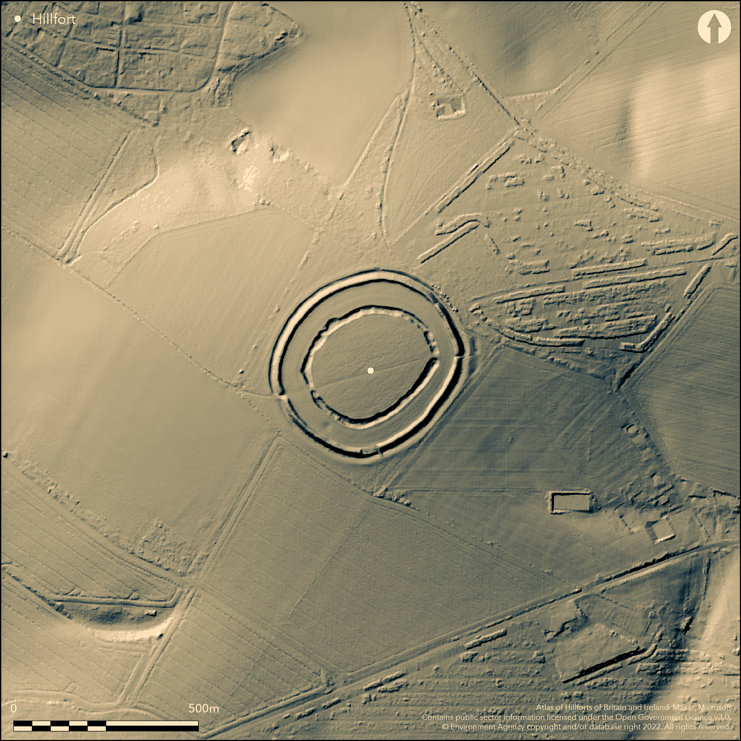
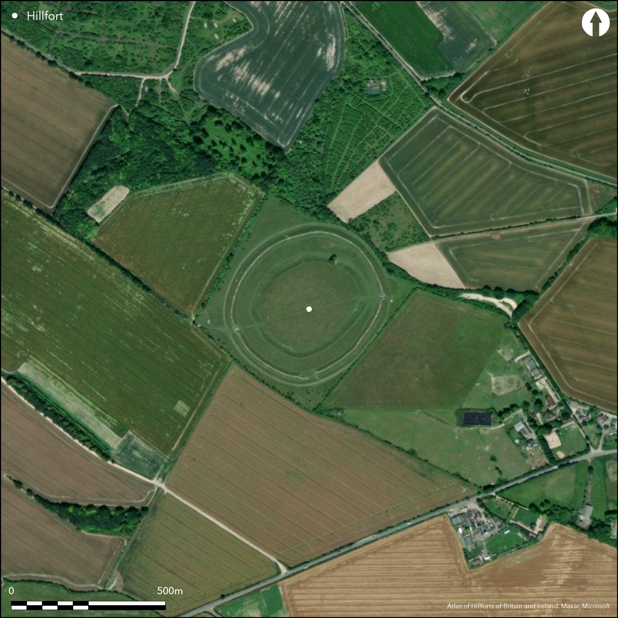
Univallate, oval, contour hillfort, with unusual interior inner ditch, located in a commanding position on W end of broad spur overlooking the River Bourne to the W and with extensive views to the River Avon valley, also to W. Steep slopes to N, W, moderate to steep on S, level to moderate corridor on E. On Andrews and Dury's Topographical Map of Wiltshire 1773. Single rampart 3.4m high above and 6m high above bottom of outer ditch 0.9m deep, encloses 6.4ha. Outside counterscarp bank 0.5m high and up to 10m wide. 40m inside the rampart, and parallel to it, is ditch averaging 14m wide up to 4.5m deep. Many irregular pits inside ditch suggest possibly unfinished. Entrances in main rampart and internal ditch in E and SW. Break in rampart of 30m in S may be either original or modern quarrying. Outer bank and outer ditch separated by a wide flat area before meeting the wide inner ditch which encircles the large interior space. Various explanations of this, from the remains of a henge or causewayed enclosure to quarry ditch, but clearly it formed an integral feature of the later enclosure. Excavated in 1924 by Maud Cunnington; interpreted site as periodic use. Ewart Park late Bronze Age sword and Bronze Age and early Iron Age pottery suggest early use. On Ist Ed. OS map (1875-6 - partial coverage).
Citizen Science: ✗
Reliability of Data: Confirmed
Reliability of Interpretation: Confirmed
X: -192841 Y: 6639599 (EPSG: 3857)
Longitude: -1.7323226330429242 Latitude: 51.1033703987412 (EPSG:4326)
Country: England
Current County or Unitary Authority: Wiltshire
Historic County: Wiltshire
Current Parish/Community/Council/Townland: Firsdown
Open National Trust site, well-managed in good condition. SSSI.
| Extant | ✓ |
| Cropmark | ✗ |
| Likely Destroyed | ✗ |
Pasture with isolated trees in interior.
| Woodland | ✗ |
| Commercial Forestry Plantation | ✗ |
| Parkland | ✗ |
| Pasture (Grazing) | ✓ |
| Arable | ✗ |
| Scrub/Bracken | ✓ |
| Bare Outcrop | ✗ |
| Heather/Moorland | ✗ |
| Heath | ✗ |
| Built-up | ✗ |
| Coastal Grassland | ✗ |
| Other | ✗ |
Univallate, oval, hillfort located in commanding position on W end of broad spur overlooking the River Bourne to the W and with extensive views to the River Avon valley, also to W. Steep slopes to N, W, moderate to steep on S, level to moderate corridor on E.
| Contour Fort | ✓ |
| Partial Contour Fort | ✗ |
| Promontory Fort | ✗ |
| Hillslope Fort | ✗ |
| Level Terrain Fort | ✗ |
| Marsh Fort | ✗ |
| Multiple Enclosure Fort | ✗ |
Sited in a strategic position on a chalk downland spur at the confluence of the River Avon and River Bourne
| Hilltop | ✗ |
| Coastal Promontory | ✗ |
| Inland Promontory | ✗ |
| Valley Bottom | ✗ |
| Knoll/Hillock/Outcrop | ✗ |
| Ridge | ✗ |
| Cliff/Plateau-edge/Scarp | ✗ |
| Hillslope | ✗ |
| Lowland | ✗ |
| Spur | ✓ |
Dominant Topographic Feature: Broad spur.
| North | ✗ |
| Northeast | ✗ |
| East | ✗ |
| Southeast | ✗ |
| South | ✗ |
| Southwest | ✗ |
| West | ✗ |
| Northwest | ✗ |
| Level | ✓ |
Altitude: 147.0m
N/A
Ewart Park late Bronze Age sword, early Iron Age and Bronze Age pottery. Possible early activity suggested by interior ditch, Grooved Ware and Beaker sherds.
Reliability: C - Low
| Pre 1200BC | ✗ |
| 1200BC - 800BC | ✓ |
| 800BC - 400BC | ✓ |
| 400BC - AD50 | ✓ |
| AD50 - AD400 | ✗ |
| AD400 - AD 800 | ✗ |
| Post AD800 | ✗ |
| Unknown | ✗ |
| Pre Hillfort: | None |
| Post Hillfort: | None |
| Artefactual: | Ewart Park late Bronze Age sword and Bronze Age pottery. |
In Aubrey's Monumenta Britannica (1665-1693). On Ist Ed. OS map (1875-6 - partial coverage). Earliest written reference in Gibson's Camden's Brittania. On Andrews and Dury's Topographical Map of Wiltshire 1773. Excavation in 1924 by M.E. Cunnington. 2004 undergraduate geophysical survey. AML geophysical survey 1981.
| 1st Identified Map Depiction (1773): | Andrews and Dury's Topographical Map of Wiltshire. |
| Excavation (1924): | M.E. Cunnington. |
| Geophysical Survey (1981): | AML |
| Geophysical Survey (2004): | Undergraduate thesis P. Dunn - Bournemouth University. |
| 1st Identified Written Reference (None): | Aubrey's Monumenta Britannica. |
| Other (None): | OS map. |
Cunnington excavation within 'plateau' interior. No details of P. Dunn undergraduate survey 2004. Ewart Park late Bronze Age sword and Bronze Age and early Iron Age pottery. Grooved ware and Beaker sherds from excavation of inner ditch. Early Iron Age sherds of All Cannings Cross type including haematite-coated ware.
None
| None | ✓ |
| Spring | ✗ |
| Stream | ✗ |
| Pool | ✗ |
| Flush | ✗ |
| Well | ✗ |
| Other | ✗ |
One theory of inner ditch is quarry hollow. Many irregular 'pits' inside ditch suggest possibly unfinished.
| No Known Features | ✗ |
| Round Stone Structures | ✗ |
| Rectangular Stone Structures | ✗ |
| Curvilinear Platforms | ✗ |
| Other Roundhouse Evidence | ✗ |
| Pits | ✗ |
| Quarry Hollows | ✓ |
| Other | ✓ |
No features from excavation.
| No Known Excavation | ✗ |
| Pits | ✗ |
| Postholes | ✗ |
| Roundhouses | ✗ |
| Rectangular Structures | ✗ |
| Roads/Tracks | ✗ |
| Quarry Hollows | ✗ |
| Other | ✗ |
| Nothing Found | ✓ |
No details of P. Dunn 2004 undergraduate survey.
| No Known Geophysics | ✗ |
| Pits | ✗ |
| Roundhouses | ✗ |
| Rectangular Structures | ✗ |
| Roads/Tracks | ✗ |
| Quarry Hollows | ✗ |
| Other | ✓ |
| Nothing Found | ✗ |
Ewart Park late Bronze Age sword and Bronze Age and early Iron Age pottery. Grooved ware and Beaker sherds from excavation of inner ditch. Early Iron Age sherds of All Cannings Cross type including haematite-coated ware. Also human and animal bone, worked flint, charcoal and burnt flint pot boilers, small piece of slag.
| No Known Finds | ✗ |
| Pottery | ✓ |
| Metal | ✓ |
| Metalworking | ✓ |
| Human Bones | ✓ |
| Animal Bones | ✓ |
| Lithics | ✓ |
| Environmental | ✓ |
| Other | ✗ |
None
| APs Not Checked | ✓ |
| None | ✗ |
| Roundhouses | ✗ |
| Rectangular Structures | ✗ |
| Pits | ✗ |
| Postholes | ✗ |
| Roads/Tracks | ✗ |
| Other | ✗ |
E and W entrances with hornwork at E.
| 2: | None |
| 2: | None |
Guard Chambers: ✗
Chevaux de Frise: ✗
| 1. Hornwork (East): | None |
| 2. Simple Gap (West): | None |
Single rampart 3.4m high above and 6m high above bottom of outer ditch 0.9m deep. Outside counterscarp bank 0.5m high and up to 10m wide. 40m inside the rampart, and parallel to it, is ditch averaging 14m wide up to 4.5m deep. Many irregular pits inside ditch suggest possibly unfinished. Bank composed of compacted chalk or large lumps of chalk and occasional large flints.
| Area 1: | 6.4ha. |
| Total: | 6.4ha. |
Total Footprint Area: Noneha.
None
| ✗ | None |
| ✓ | Fine circuit. |
| NE Quadrant: | 1 |
| SE Quadrant: | 1 |
| SW Quadrant: | 1 |
| NW Quadrant: | 1 |
| Total: | 1 |
| Partial Univallate | ✗ |
| Univallate | ✓ |
| Partial Bivallate | ✗ |
| Bivallate | ✗ |
| Partial Multivallate | ✗ |
| Multivallate | ✗ |
| Unknown | ✗ |
| Partial Univallate | ✗ |
| Univallate | ✗ |
| Partial Bivallate | ✗ |
| Bivallate | ✗ |
| Partial Multivallate | ✗ |
| Multivallate | ✗ |
Many irregular 'pits' inside ditch suggest possibly unfinished.
| None | ✗ |
| Earthen Bank | ✓ |
| Stone Wall | ✗ |
| Rubble | ✓ |
| Wall-walk | ✗ |
| Evidence of Timber | ✗ |
| Vitrification | ✗ |
| Other Burning | ✗ |
| Palisade | ✗ |
| Counter Scarp Bank | ✓ |
| Berm | ✗ |
| Unfinished | ✓ |
| Other | ✗ |
Bank composed of compacted chalk or large lumps of chalk and occasional large flints.
| None | ✗ |
| Earthen Bank | ✓ |
| Stone Wall | ✗ |
| Murus Duplex | ✗ |
| Timber-framed | ✗ |
| Timber-laced | ✗ |
| Vitrification | ✗ |
| Other Burning | ✗ |
| Palisade | ✗ |
| Counter Scarp Bank | ✗ |
| Berm | ✗ |
| Unfinished | ✗ |
| No Known Excavation | ✗ |
| Other | ✗ |
| ✓ | Possible evidence. Rampart constructed in short, straight lengths, with marked changes of alignment (Payne at al 2006, 112). |
| ✓ | Inner and outer ditches. |
Number of Ditches: 2
| ✗ | None |
Brown, I.W. 2009. Beacons in the landscape. the hillforts of England and Wales, Oxford: Windgather Press/Oxbow, 223.
Cunnington, M. 1924: Figsbury Rings: an account of the excavations in 1924. Wiltshire Archaeol Natur Hist Mag, 43, (1925), 48-58.
Dunn, P, 2004. Defining The Circle: a multidisciplinary study of Figsbury Ring in South Wiltshire and a reassessment of its past. BSc disseration, Bournemouth University.
Gater ,J. 1981 GEOPHYSICS : FIGSBURY RINGS AM LAB REPORT (OLD SERIES) 3554
Pugh, R.B. and Crittall, E. eds 1957. A history of Wiltshire, 1.1, The Victoria history of the counties of England, Oxford: OUP, 124, 271.
Atlas of Hillforts:
Wikidata:
This work is licensed under CC BY-SA 4.0![]()
![]()
![]() and should be cited as:
and should be cited as:
Lock, Gary and Ralston, Ian. 2024. Atlas of Hillforts of Britain and Ireland. Available at: https://hillforts.arch.ox.ac.uk
Document Version 1.1