LiDAR 1m DTM Hillshade
Satellite Imagery
LiDAR 1m DTM Hillshade
Satellite Imagery
Scroll left/right to view further images.
HER: Wiltshire and Swindon MWI11119 (None)
NMR: SU 13 SW 30 (218530)
SM: 1015675
NGR: SU13773269
X: 413779 Y: 132698 (OSGB36)
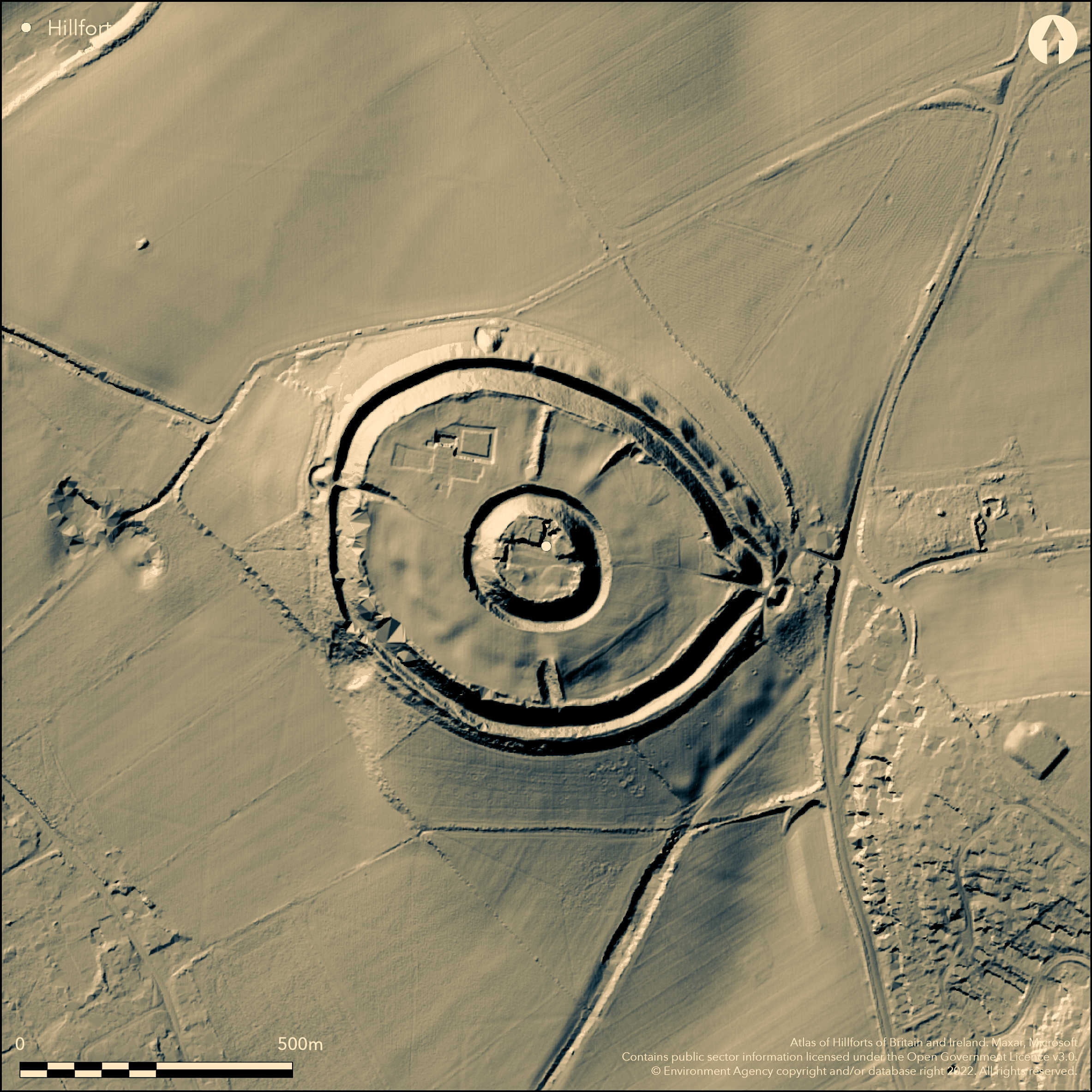
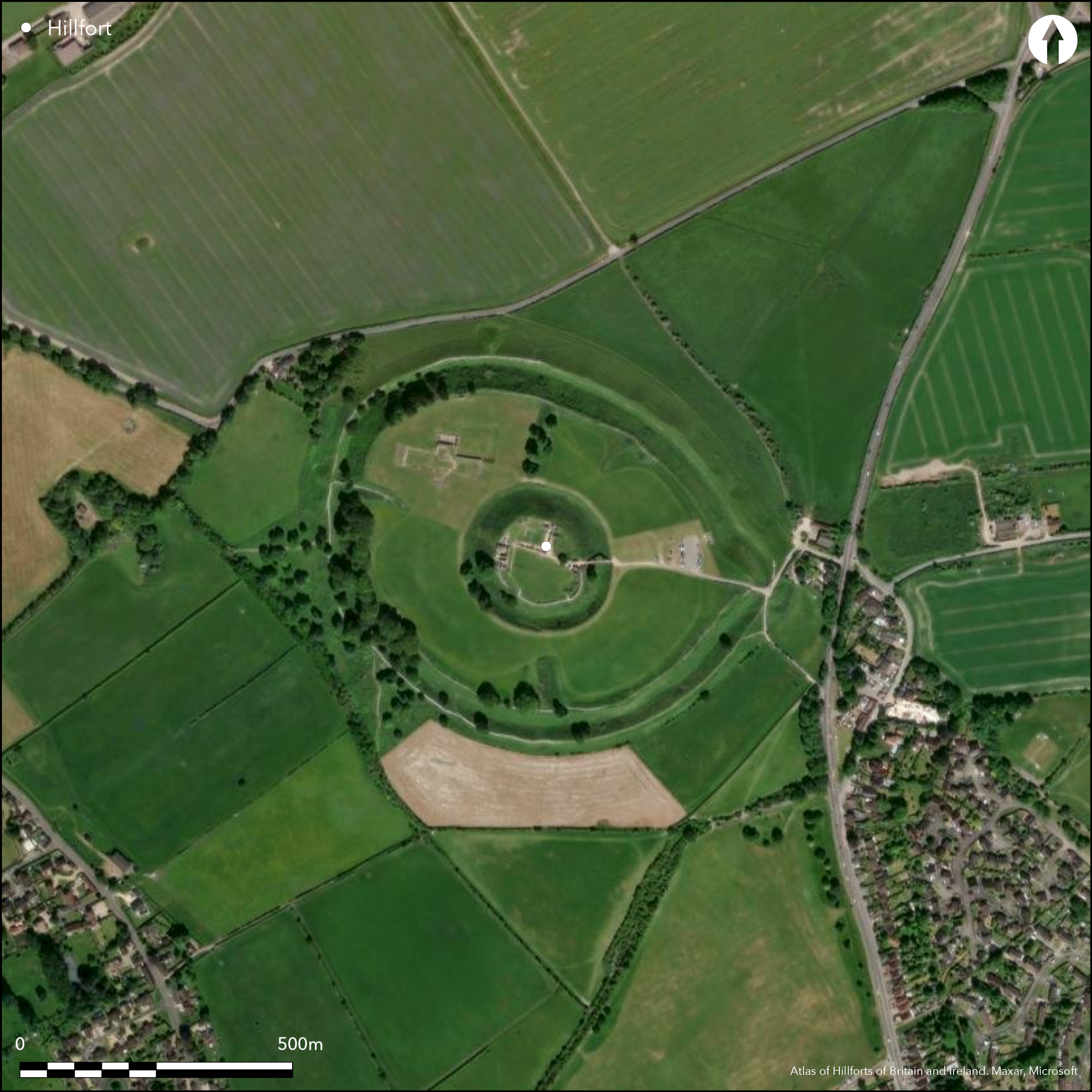
Large, multivallate, contour hillfort, oval in plan, and strategically sited on a prominent knoll at the W end of a W-facing chalk spur overlooking the River Avon at its confluence with the Rivers Nadder and Bourne. Originally univallate, site substantially altered in later periods, within which William I founded a castle, deepening the ditch to provide additional outer defence. Roman town of Sorviodunum suggested as lying within the hillfort, but Romano-British occupation questioned. In 1070 cathedral established, as part of the reorganisation of the English Church by the Normans, in zone between the castle and ramparts within the perimeter of the fort, and a town, later to be abandoned in 1220's in favour of New Sarum, modern Salisbury. Hillfort measures 580m E-W by 460m N-S, with convex interior and well preserved. Defences, now enclosing c. 12ha, originally had single bank and ditch, but now include internal bank, substantial steep-sided ditch, 30m wide in places, and, at lower level on the slope, an outer bank. Two entrances visible, one on E side approached by causeway and one on W thought to be medieval. When hillfort originally univallate, possible entrance on NE, but when subsequently developed with bivallate defences, entrance on E. Entrance at W end later blocked and now contains underground passage, whilst that at E end has continued to function as main entrance into fort and protected by outer hornwork or barbican. Earthworks within interior comprise two radial banks, with traces of ditch on W side. One of banks present to S of medieval castle mound, other to N. Date of both earthworks not known. Excavations in interior found evidence of early Iron Age settlement and of later Iron Age and Romano-British occupation from the 1st to 3rd centuries AD. Excavations by St John Hope in 1911 found Iron Age pit in S. Area of Iron Age activity outside hillfort close to E entrance. Guardianship site under managed grassland in good condition. Grassland and developments. On Ist Ed. OS map (1881).
Citizen Science: ✗
Reliability of Data: Confirmed
Reliability of Interpretation: Confirmed
X: -200891 Y: 6637826 (EPSG: 3857)
Longitude: -1.8046359920300457 Latitude: 51.09337028400596 (EPSG:4326)
Country: England
Current County or Unitary Authority: Wiltshire
Historic County: Wiltshire
Current Parish/Community/Council/Townland: Salisbury City
Guardianship site well-managed. Old Sarum and developments.
| Extant | ✓ |
| Cropmark | ✗ |
| Likely Destroyed | ✗ |
Managed grassland. Old Sarum and developments.
| Woodland | ✗ |
| Commercial Forestry Plantation | ✗ |
| Parkland | ✗ |
| Pasture (Grazing) | ✓ |
| Arable | ✗ |
| Scrub/Bracken | ✗ |
| Bare Outcrop | ✗ |
| Heather/Moorland | ✗ |
| Heath | ✗ |
| Built-up | ✓ |
| Coastal Grassland | ✗ |
| Other | ✓ |
Large, multivallate, contour hillfort, oval in plan and strategically sited at the W end of a W-facing chalk spur overlooking the River Avon at its confluence with the Rivers Nadder and Bourne.
| Contour Fort | ✓ |
| Partial Contour Fort | ✗ |
| Promontory Fort | ✗ |
| Hillslope Fort | ✗ |
| Level Terrain Fort | ✗ |
| Marsh Fort | ✗ |
| Multiple Enclosure Fort | ✗ |
Strategically sited on a prominent knoll above the River Avon at its confluence with the Rivers Nadder and Bourne.
| Hilltop | ✗ |
| Coastal Promontory | ✗ |
| Inland Promontory | ✗ |
| Valley Bottom | ✗ |
| Knoll/Hillock/Outcrop | ✗ |
| Ridge | ✗ |
| Cliff/Plateau-edge/Scarp | ✗ |
| Hillslope | ✗ |
| Lowland | ✗ |
| Spur | ✓ |
Dominant Topographic Feature: Prominent chalk spur.
| North | ✗ |
| Northeast | ✗ |
| East | ✗ |
| Southeast | ✗ |
| South | ✗ |
| Southwest | ✗ |
| West | ✗ |
| Northwest | ✗ |
| Level | ✓ |
Altitude: 100.0m
N/A
Excavations in interior found evidence of early Iron Age settlement and of later Iron Age and possible Romano-British occupation from the 1st to 3rd centuries AD. Excavations by St John Hope in 1911 found Iron Age pit in S.
Reliability: C - Low
| Pre 1200BC | ✗ |
| 1200BC - 800BC | ✗ |
| 800BC - 400BC | ✓ |
| 400BC - AD50 | ✓ |
| AD50 - AD400 | ✓ |
| AD400 - AD 800 | ✗ |
| Post AD800 | ✗ |
| Unknown | ✗ |
| Pre Hillfort: | None |
| Post Hillfort: | None |
| Morphology/Earthwork/Typology: | Excavations in interior. |
In Aubrey's Monumenta Britannica (1665-1693). On Ist Ed. OS map (1881). Variety of excavations, first in 1796 by Mr Ogden, H. Hatcher 1835 and J. Yonge Ackerman 1854. Castle, cathedral and other ecclesiastical buildings within the outer bailey within hillfort interior excavated between 1909 and 1915 by W. H. St. J. Hope, W. Hawley and D. H. Montgomerie for the Society of Antiquaries of London. Further excavations carried out by J.F.S. Stone and J. Charlton in 1930's and J. Musty and P. A. Rahtz in 1950s. Numerous Watching Briefs between 1974 and 2008 recorded; assessments. management plan and EIA. Geophysical survey 2015.
| Excavation (1796): | Mr Ogden. |
| Excavation (1835): | H. Hatcher. |
| Excavation (1854): | J. Yonge Ackerman. |
| 1st Identified Map Depiction (1881): | OS map. |
| Excavation (1957): | J. Musty and P. A. Rahtz. |
| Excavation (1967): | D.J. Algar and T.J. MIles. Included in Watching Brief for sewer. |
| Other (1984): | Visited by Hillfort Study Group |
| Other (1990): | EH management plan. |
| Geophysical Survey (2015): | None |
| 1st Identified Written Reference (None): | None |
| Excavation (None): | W. H. St. J. Hope, W. Hawley and D. H. Montgomerie for the Society of Antiquaries of London. |
| Excavation (None): | J.F.S. Stone and J. Charlton, trial Excavations. |
| Other (None): | Watching Briefs. |
Excavations in interior found evidence of early Iron Age settlement and of later Iron Age and Romano-British occupation from the 1st to 3rd centuries AD. Excavations by St John Hope in 1911 found Iron Age pit in S. Strap- union horse trapping chance find.
None
| None | ✓ |
| Spring | ✗ |
| Stream | ✗ |
| Pool | ✗ |
| Flush | ✗ |
| Well | ✗ |
| Other | ✗ |
Later developments in interior.
| No Known Features | ✓ |
| Round Stone Structures | ✗ |
| Rectangular Stone Structures | ✗ |
| Curvilinear Platforms | ✗ |
| Other Roundhouse Evidence | ✗ |
| Pits | ✗ |
| Quarry Hollows | ✗ |
| Other | ✗ |
Excavations in interior found evidence of early Iron Age settlement and of later Iron Age and Romano-British occupation from the 1st to 3rd centuries AD. Excavations by St John Hope in 1911 found Iron Age pit in S.
| No Known Excavation | ✗ |
| Pits | ✓ |
| Postholes | ✗ |
| Roundhouses | ✗ |
| Rectangular Structures | ✗ |
| Roads/Tracks | ✗ |
| Quarry Hollows | ✗ |
| Other | ✓ |
| Nothing Found | ✗ |
None
| No Known Geophysics | ✓ |
| Pits | ✗ |
| Roundhouses | ✗ |
| Rectangular Structures | ✗ |
| Roads/Tracks | ✗ |
| Quarry Hollows | ✗ |
| Other | ✗ |
| Nothing Found | ✗ |
Strap-union horse trapping chance find.
| No Known Finds | ✗ |
| Pottery | ✗ |
| Metal | ✓ |
| Metalworking | ✗ |
| Human Bones | ✗ |
| Animal Bones | ✗ |
| Lithics | ✗ |
| Environmental | ✗ |
| Other | ✗ |
None
| APs Not Checked | ✓ |
| None | ✗ |
| Roundhouses | ✗ |
| Rectangular Structures | ✗ |
| Pits | ✗ |
| Postholes | ✗ |
| Roads/Tracks | ✗ |
| Other | ✗ |
Two entrances can be seen, one on the E side approached by causeway and one on the W side thought to be medieval. When hillfort originally univallate, possible entrance on NE, but when subsequently developed with bivallate defences, entrance on E. Entrance at W end later blocked and now contains underground passage, while that at the E end has continued to function as main entrance into fort and protected by outer hornwork or barbican.
| 2: | None |
| 2: | Entrance where cars now enter the site on E side |
Guard Chambers: ✗
Chevaux de Frise: ✗
| 1. Hornwork (East): | Approached by causeway and protected by hornwork or barbican. |
| 1. Barbican (East): | Protected by hornwork or barbican. |
| 2. Blocked (West): | Entrance at W end later blocked and now contains underground passage. |
Hillfort measures 580m E-W by 460m N-S, with convex interior and well preserved. Defences, now enclosing c. 12ha, originally had single bank and ditch, but now include internal bank, substantial steep-sided ditch, 30m wide in places, and, at lower level on the slope, an outer bank.
| Area 1: | 12.0ha. |
| Total: | 12.0ha. |
Total Footprint Area: Noneha.
None
| ✓ | Originally univallate, subsequently altered. |
| ✓ | None |
| NE Quadrant: | 2 |
| SE Quadrant: | 2 |
| SW Quadrant: | 2 |
| NW Quadrant: | 2 |
| Total: | 2 |
| Partial Univallate | ✗ |
| Univallate | ✗ |
| Partial Bivallate | ✗ |
| Bivallate | ✓ |
| Partial Multivallate | ✗ |
| Multivallate | ✗ |
| Unknown | ✗ |
| Partial Univallate | ✗ |
| Univallate | ✓ |
| Partial Bivallate | ✗ |
| Bivallate | ✗ |
| Partial Multivallate | ✗ |
| Multivallate | ✗ |
None
| None | ✗ |
| Earthen Bank | ✓ |
| Stone Wall | ✗ |
| Rubble | ✗ |
| Wall-walk | ✗ |
| Evidence of Timber | ✗ |
| Vitrification | ✗ |
| Other Burning | ✗ |
| Palisade | ✗ |
| Counter Scarp Bank | ✗ |
| Berm | ✗ |
| Unfinished | ✗ |
| Other | ✗ |
Excavations in interior.
| None | ✗ |
| Earthen Bank | ✗ |
| Stone Wall | ✗ |
| Murus Duplex | ✗ |
| Timber-framed | ✗ |
| Timber-laced | ✗ |
| Vitrification | ✗ |
| Other Burning | ✗ |
| Palisade | ✗ |
| Counter Scarp Bank | ✗ |
| Berm | ✗ |
| Unfinished | ✗ |
| No Known Excavation | ✓ |
| Other | ✗ |
| ✗ | None |
| ✓ | Substantial ditch. |
Number of Ditches: 1
| ✗ | None |
Anon. 2015. Old Sarum survey reveals lost city. Current Archaeol, 299, 6.
Darvill, T., Stamper, P. and Timby, J. 2002: England an archaeological guide. Oxford: OUP, 403.
Pitts, M. 2015. Survey reveals Old Sarum was a major town. Brit Archaeol, January/February 2015, 6-7.
Rahtz P. A .and Musty J. 1964.The Suburbs of Old Sarum, Wiltshire Archaeol Natur Hist Mag, 59, 130-154.
Rahtz, P A and Musty, J .W. G 1960. Excavations at Old Sarum 1957, Wiltshire Archaeol Natur Hist Mag, 57, 353-370.
RCHME 1980. Ancient and historical monuments in the City of Salisbury, London: HMSO, 1-24.
Stone, J. F. S. and Charlton, J. 1935. Trial Excavations in the Esst Suburb of Old Sarum, Ant J, 15, 174-192.
Atlas of Hillforts:
Wikidata:
This work is licensed under CC BY-SA 4.0![]()
![]()
![]() and should be cited as:
and should be cited as:
Lock, Gary and Ralston, Ian. 2024. Atlas of Hillforts of Britain and Ireland. Available at: https://hillforts.arch.ox.ac.uk
Document Version 1.1