LiDAR 1m DTM Hillshade
Satellite Imagery
LiDAR 1m DTM Hillshade
Satellite Imagery
Scroll left/right to view further images.
HER: Wiltshire and Swindon MWI12551 (None)
NMR: SU 14 SW69 (1012126)
SM: 219627
NGR: SU14704166
X: 414703 Y: 141666 (OSGB36)
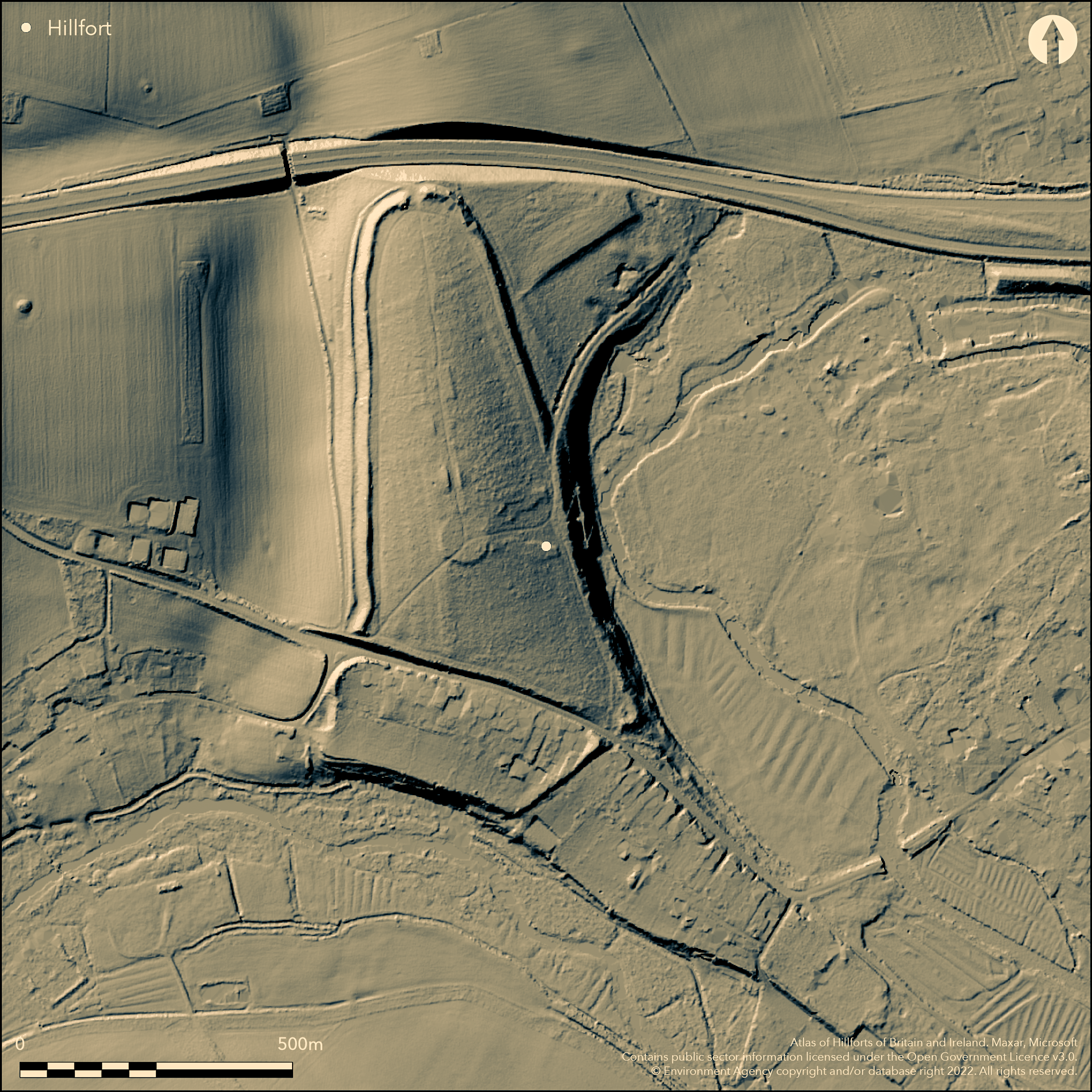
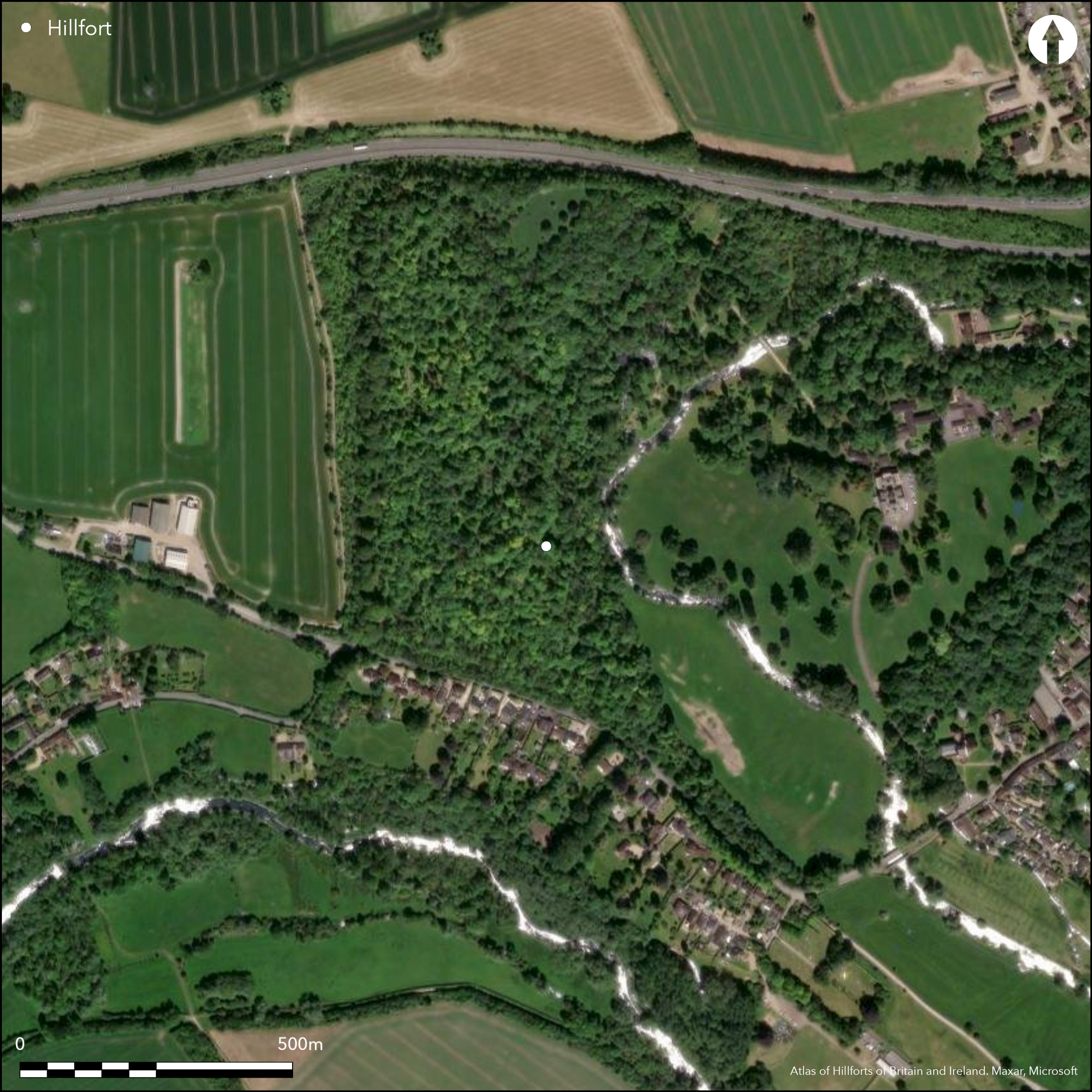
Univallate contour hillfort located on wooded hill in a commanding position with steep E and S sides to the River Avon, c. 2km E of Stonehenge. Single bank and ditch encloses rough triangular site of 16ha cutting across spur formed by bend of the river. Best preserved on W where top bank 6.5m above ditch and 2m above interior, much alteration by 18th century landscaping and agricultural activity. Counterscarp accentuates ditch on W side. Entrance at N tip. Ancient roadway from Amesbury to Stonehenge crosses S part of fort, possibly using SE and SW entrances (Bowden 2016), some building S of road. Road widening in 1964 with small 1987 excavation in interior and close to S rampart showed that enclosure built in mid 1st millennium BC and enlarged shortly afterwards (Hunter-Mann 1999). All pottery found was early Iron Age c. 5th century BC, the most diagnostic being fragments of locally manufactured scratch cordoned bowls. The excavation also found a post-hole/small pit. The rampart building was followed by a period of intense occupation of the hillfort, represented by deposits of domestic waste over 1m thick accumulated against the inner face of the ramparts. No secondary occupation deposits. Several barrows in the interior. On Ist Ed. OS map (1878-79).
Citizen Science: ✗
Reliability of Data: Confirmed
Reliability of Interpretation: Confirmed
X: -199382 Y: 6652128 (EPSG: 3857)
Longitude: -1.7910780203824508 Latitude: 51.17398914877672 (EPSG:4326)
Country: England
Current County or Unitary Authority: Wiltshire
Historic County: Wiltshire
Current Parish/Community/Council/Townland: Amesbury
Fair condition. Best on W. Built on S of ancient road.
| Extant | ✓ |
| Cropmark | ✗ |
| Likely Destroyed | ✗ |
Wooded spur. Built on S of ancient road.
| Woodland | ✓ |
| Commercial Forestry Plantation | ✗ |
| Parkland | ✗ |
| Pasture (Grazing) | ✗ |
| Arable | ✗ |
| Scrub/Bracken | ✗ |
| Bare Outcrop | ✗ |
| Heather/Moorland | ✗ |
| Heath | ✗ |
| Built-up | ✓ |
| Coastal Grassland | ✗ |
| Other | ✗ |
Univallate contour hillfort located on wooded spur formed by bend in River Avon in a commanding position with steep E and S sides down to the river.
| Contour Fort | ✓ |
| Partial Contour Fort | ✗ |
| Promontory Fort | ✗ |
| Hillslope Fort | ✗ |
| Level Terrain Fort | ✗ |
| Marsh Fort | ✗ |
| Multiple Enclosure Fort | ✗ |
Strategically sited on a rising spur above the great horseshoe bend of the River Avon at Amesbury.
| Hilltop | ✗ |
| Coastal Promontory | ✗ |
| Inland Promontory | ✗ |
| Valley Bottom | ✗ |
| Knoll/Hillock/Outcrop | ✗ |
| Ridge | ✗ |
| Cliff/Plateau-edge/Scarp | ✗ |
| Hillslope | ✗ |
| Lowland | ✗ |
| Spur | ✓ |
Dominant Topographic Feature: Spur above River Avon.
| North | ✗ |
| Northeast | ✗ |
| East | ✗ |
| Southeast | ✗ |
| South | ✗ |
| Southwest | ✗ |
| West | ✗ |
| Northwest | ✗ |
| Level | ✓ |
Altitude: 90.0m
N/A
Early Iron Age occupation - pottery dating mainly to the 5th century BC, the most diagnostic being fragments of locally manufactured scratch cordoned bowls, with middle Iron Age types being almost entirely absent.
Reliability: B - Medium
| Pre 1200BC | ✗ |
| 1200BC - 800BC | ✗ |
| 800BC - 400BC | ✓ |
| 400BC - AD50 | ✗ |
| AD50 - AD400 | ✗ |
| AD400 - AD 800 | ✗ |
| Post AD800 | ✗ |
| Unknown | ✗ |
| Pre Hillfort: | None |
| Post Hillfort: | None |
| Artefactual: | Early Iron Age pottery. |
In Aubrey's Monumenta Britannica (1665-1693). On Ist Ed. OS map (1878-79). Excavation by Faith Vatcher in 1968 and Kurt Hunter-Mann 1987. Geophysical Surveys in 1995 in the S part. Watching brief in 2001, at Skye House. Survey 2016.
| 1st Identified Map Depiction (1812): | Philip Crocker's map of Stonehenge environs showing location of site in Colt Hoare (1812). |
| Excavation (1968): | Undertaken by Faith Vacher |
| Other (1984): | Visited by Hillfort Study Group |
| Excavation (1987): | Undertaken by Kurt Hunter-Mann. |
| Geophysical Survey (1995): | AML |
| Other (2001): | EH Stonehenge WHS M/Prog. Aerial photograph interpretation and measured survey. |
| Earthwork Survey (2016): | Historic England |
| 1st Identified Written Reference (None): | Aubrey's Monumenta Britannica. |
| Other (None): | OS map. |
| Other (None): | RCAHME Salisbury Plan Training Area NMP. |
| Other (None): | Watching briefs. |
Pottery dating mainly to the 5th century BC, with middle Iron Age types being almost entirely absent. Worked flint and possible Roman tile from watching brief 1996. Geophysical Surveys in 1995 in S part revealed linear anomaly enclosing a semi-circular area approximately 30m in diameter which probably represents a cut, a ditch, a dwelling or a Bronze Age barrow. The hillfort rampart clearly visible. A narrow band may represent a revetment or counterscarp feature. The 1987 excavation also found a post-hole/small pit.
None
| None | ✓ |
| Spring | ✗ |
| Stream | ✗ |
| Pool | ✗ |
| Flush | ✗ |
| Well | ✗ |
| Other | ✗ |
None
| No Known Features | ✓ |
| Round Stone Structures | ✗ |
| Rectangular Stone Structures | ✗ |
| Curvilinear Platforms | ✗ |
| Other Roundhouse Evidence | ✗ |
| Pits | ✗ |
| Quarry Hollows | ✗ |
| Other | ✗ |
The 1987 excavation found a posthole/small pit.
| No Known Excavation | ✗ |
| Pits | ✓ |
| Postholes | ✓ |
| Roundhouses | ✗ |
| Rectangular Structures | ✗ |
| Roads/Tracks | ✗ |
| Quarry Hollows | ✗ |
| Other | ✗ |
| Nothing Found | ✗ |
Geophysical Surveys in 1995 in the S part of revealed linear anomaly enclosing a semi-circular area approximately 30m in diameter which probably represents a cut, a ditch, a dwelling or a Bronze Age barrow. The hillfort rampart is clearly visible. A narrow band may represent a revetment or counterscarp feature.
| No Known Geophysics | ✗ |
| Pits | ✗ |
| Roundhouses | ✓ |
| Rectangular Structures | ✗ |
| Roads/Tracks | ✗ |
| Quarry Hollows | ✗ |
| Other | ✓ |
| Nothing Found | ✗ |
Pottery dating mainly to the 5th century BC, with middle Iron Age types being almost entirely absent. Worked flint and possible Roman tile.
| No Known Finds | ✗ |
| Pottery | ✓ |
| Metal | ✗ |
| Metalworking | ✗ |
| Human Bones | ✗ |
| Animal Bones | ✗ |
| Lithics | ✓ |
| Environmental | ✗ |
| Other | ✓ |
None
| APs Not Checked | ✓ |
| None | ✗ |
| Roundhouses | ✗ |
| Rectangular Structures | ✗ |
| Pits | ✗ |
| Postholes | ✗ |
| Roads/Tracks | ✗ |
| Other | ✗ |
Entrance at N tip. Ancient roadway from Amesbury to Stonehenge crosses S part of fort, possibly using SE and SW entrances entrance.
| 3: | None |
| 2: | None |
Guard Chambers: ✗
Chevaux de Frise: ✗
| 1. Simple Gap (North): | None |
| 2. Simple Gap (South east): | None |
Single bank and ditch encloses rough triangular site of 16ha cutting across spur formed by bend of the river. Best preserved on W where top bank 6.5m above ditch and 2m above interior. Counterscarp accentuates ditch on W side. Excavation showed 1m thick deposits dumped on the rampart separating chalk rubble of two main phases of construction.
| Area 1: | 16.0ha. |
| Total: | 16.0ha. |
Total Footprint Area: Noneha.
None
| ✓ | Excavation showed 1m thick deposits dumped on the rampart separating chalk rubble of two main phases of construction. |
| ✓ | Phased. |
| NE Quadrant: | 1 |
| SE Quadrant: | 1 |
| SW Quadrant: | 1 |
| NW Quadrant: | 1 |
| Total: | 1 |
| Partial Univallate | ✗ |
| Univallate | ✓ |
| Partial Bivallate | ✗ |
| Bivallate | ✗ |
| Partial Multivallate | ✗ |
| Multivallate | ✗ |
| Unknown | ✗ |
| Partial Univallate | ✗ |
| Univallate | ✗ |
| Partial Bivallate | ✗ |
| Bivallate | ✗ |
| Partial Multivallate | ✗ |
| Multivallate | ✗ |
Geophysics indicates narrow band may represent a revetment or counterscarp feature.
| None | ✗ |
| Earthen Bank | ✓ |
| Stone Wall | ✓ |
| Rubble | ✗ |
| Wall-walk | ✗ |
| Evidence of Timber | ✗ |
| Vitrification | ✗ |
| Other Burning | ✗ |
| Palisade | ✗ |
| Counter Scarp Bank | ✓ |
| Berm | ✗ |
| Unfinished | ✗ |
| Other | ✗ |
Excavation showed 1m thick deposits dumped on the rampart separating chalk rubble of two main phases of construction.
| None | ✗ |
| Earthen Bank | ✓ |
| Stone Wall | ✗ |
| Murus Duplex | ✗ |
| Timber-framed | ✗ |
| Timber-laced | ✗ |
| Vitrification | ✗ |
| Other Burning | ✗ |
| Palisade | ✗ |
| Counter Scarp Bank | ✗ |
| Berm | ✗ |
| Unfinished | ✗ |
| No Known Excavation | ✗ |
| Other | ✗ |
| ✗ | None |
| ✓ | None |
Number of Ditches: 1
| ✗ | None |
Anon 1998. Excavation and fieldwork in Wiltshire 1996, Wiltshire Archaeol Natur Hist Mag, 91, 152-66.
Bowden, M. 2016. Stonehenge Southern WHS Survey: Vespasian's Camp, Amesbury, Wiltshire: interim report on analytical earthwork survey. Historic England.
Bowden, MCB, Soutar, S, Field, DJ and Barber, M. 2015. The Stonehenge Landscape: analysing the Stonehenge World Heritage Site. Historic England: Swindon
Canham, R 1996. Wiltshire News-Wiltshire County Council: Libraries, Museums and Art. CBA Wessex Newsletter April 1996. 18-19
Cole, M. A. 1995. VESPASIAN'S CAMP, AMESBURY, WILTSHIRE, REPORT ON GEOPHYSICAL SURVEY, AUGUST 1995, AM LAB REPORT 44/95.
Hoare, R.C. 1812. The ancient history of South Wiltshire, Vol 1, London: William Miller, 219-20, (re-published 1975, Wakefield: EP publishing).
Hunter-Mann, K. 1999. Excavations at Vespasian's Camp Iron Age hillfort, Wiltshire Archaeol Natur Hist Mag, 92, 39-52.
Jacques, D, Phillips, T and Lyons, T 2012 Vespasian's Camp: the cradle of Stonehenge? Current Archaeol, 271, 28-33
RCHME, 1979. The Stonehenge Environs: monuments and land use. Royal Commission on the Historical Monuments of England/Edinburgh University Press: Edinburgh
Atlas of Hillforts:
Wikidata:
This work is licensed under CC BY-SA 4.0![]()
![]()
![]() and should be cited as:
and should be cited as:
Lock, Gary and Ralston, Ian. 2024. Atlas of Hillforts of Britain and Ireland. Available at: https://hillforts.arch.ox.ac.uk
Document Version 1.1