LiDAR 1m DTM Hillshade
Satellite Imagery
LiDAR 1m DTM Hillshade
Satellite Imagery
Scroll left/right to view further images.
HER: Wiltshire and Swindon MWI113701 (None)
NMR: SU 15 SE 7 (220236)
SM: None
NGR: SU15195387
X: 415191 Y: 153873 (OSGB36)
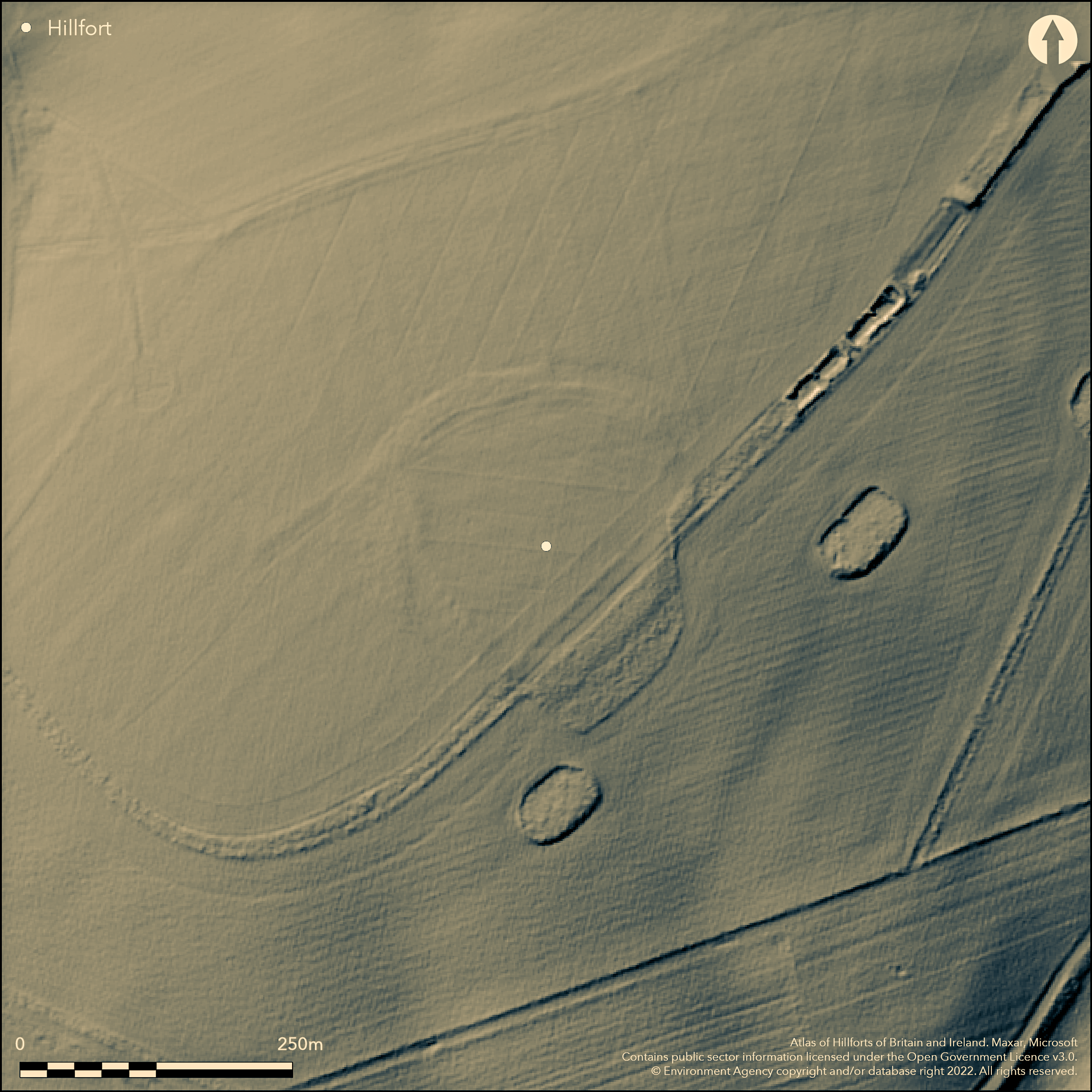
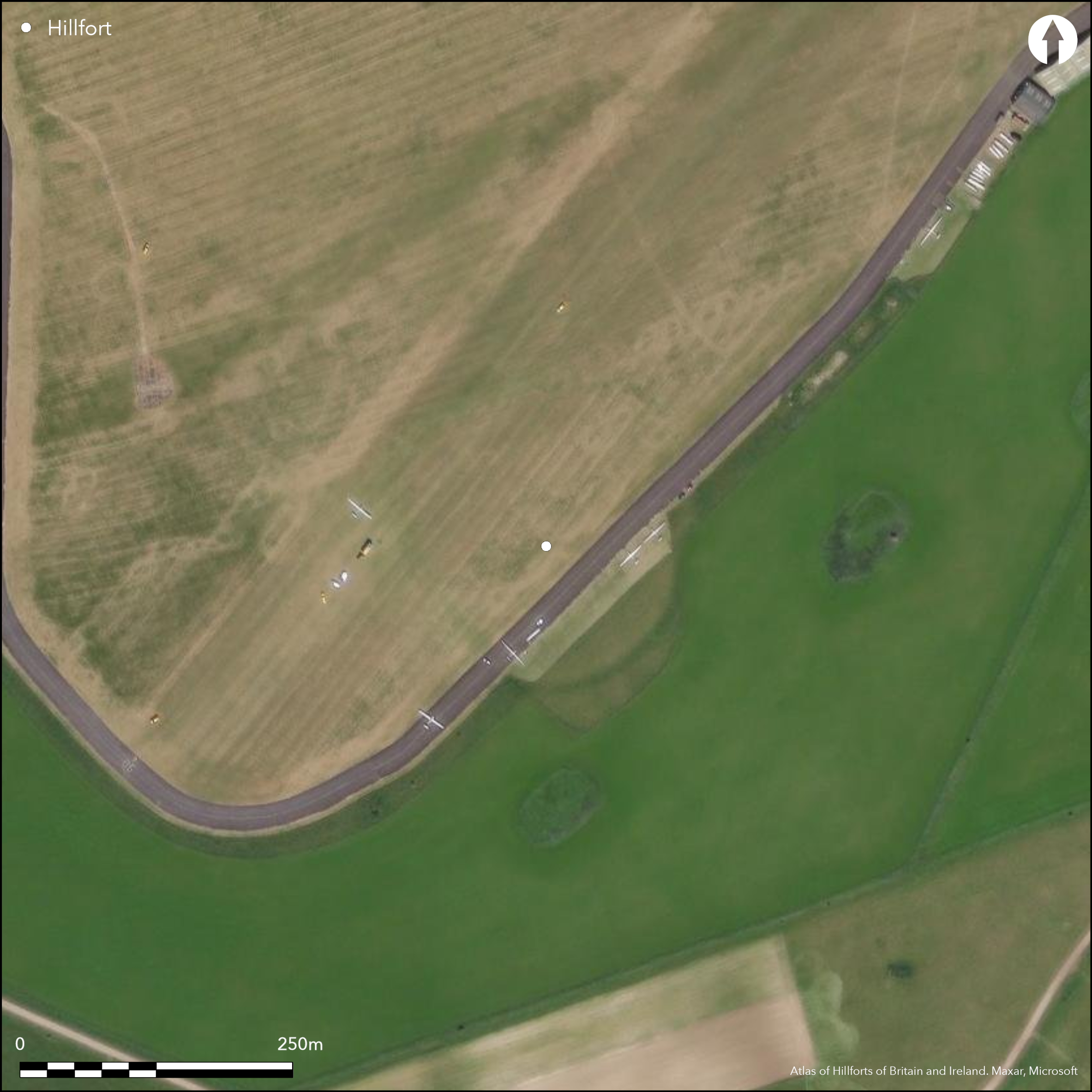
Small, sub-circular, hillslope fort on undulating Upavon Down, with shallow banks enclosing 1.8ha, partly levelled in 1931 when Upavon Airfield extended. In an area of substantial Romano-British activity. Earthwork now consists of spread bank up to 0.3m high, except on S where a scarp reaches to 1m high, with external ditch and hints of counterscarp. No trace of S entrance or former outwork mentioned by Colt Hoare, either on the ground or on aerial photographs. Prior to levelling, best preserved bank to 2m high. Vestiges of `Celtic' field system underlying enclosure remain and spread N, as described in RCHME field survey 1993. Also noted were a number of parchmarks which probably represent position of small pits. Small-scale excavation (Cunnington 1932-4), finds included pottery (probably Iron Age), piece of loom weight, three worked chalk discs, bone counter and human jawbone. On Ist Ed. OS map (1886-87).
Citizen Science: ✗
Reliability of Data: Confirmed
Reliability of Interpretation: Confirmed
X: -198548 Y: 6671639 (EPSG: 3857)
Longitude: -1.783583186422514 Latitude: 51.28374187409613 (EPSG:4326)
Country: England
Current County or Unitary Authority: Wiltshire
Historic County: Wiltshire
Current Parish/Community/Council/Townland: Enford
Part-levelled and cultivated. Road passes through site NE-SW.
| Extant | ✓ |
| Cropmark | ✗ |
| Likely Destroyed | ✗ |
Cultivated downland. Road.
| Woodland | ✗ |
| Commercial Forestry Plantation | ✗ |
| Parkland | ✗ |
| Pasture (Grazing) | ✗ |
| Arable | ✓ |
| Scrub/Bracken | ✗ |
| Bare Outcrop | ✗ |
| Heather/Moorland | ✗ |
| Heath | ✗ |
| Built-up | ✗ |
| Coastal Grassland | ✗ |
| Other | ✓ |
Small sub-circular downland hillslope fort on undulating Upavon Down.
| Contour Fort | ✗ |
| Partial Contour Fort | ✗ |
| Promontory Fort | ✗ |
| Hillslope Fort | ✓ |
| Level Terrain Fort | ✗ |
| Marsh Fort | ✗ |
| Multiple Enclosure Fort | ✗ |
Located on the southern slopes of a prominent spur of Upavon Down above the River Avon
| Hilltop | ✗ |
| Coastal Promontory | ✗ |
| Inland Promontory | ✗ |
| Valley Bottom | ✗ |
| Knoll/Hillock/Outcrop | ✗ |
| Ridge | ✗ |
| Cliff/Plateau-edge/Scarp | ✗ |
| Hillslope | ✓ |
| Lowland | ✗ |
| Spur | ✗ |
Dominant Topographic Feature: Undulating downland.
| North | ✗ |
| Northeast | ✗ |
| East | ✗ |
| Southeast | ✗ |
| South | ✓ |
| Southwest | ✗ |
| West | ✗ |
| Northwest | ✗ |
| Level | ✗ |
Altitude: 154.0m
N/A
Small-scale excavation (Cunnington 1932-4), finds included pottery (probably Iron Age), piece of loom weight, three worked chalk discs, bone counter and human jawbone.
Reliability: C - Low
| Pre 1200BC | ✗ |
| 1200BC - 800BC | ✗ |
| 800BC - 400BC | ✓ |
| 400BC - AD50 | ✓ |
| AD50 - AD400 | ✗ |
| AD400 - AD 800 | ✗ |
| Post AD800 | ✗ |
| Unknown | ✗ |
| Pre Hillfort: | None |
| Post Hillfort: | None |
| Artefactual: | None |
On Ist Ed. OS map (1886-87). Excavation Maud Cunnington 1931. RCHME field survey of Salisbury Plain Training Area 1991, survey ref. no. 888341.
| Excavation (1931): | M.E. Cunnington and B. Cunnington. |
| Earthwork Survey (1991): | RCHME field survey of Salisbury Plain Training Area.. |
| 1st Identified Map Depiction (None): | OS map. |
Parchmarks probably represent position of small pits. Finds included pottery, piece of loom weight, three worked chalk discs, bone counter and human jawbone.
None
| None | ✓ |
| Spring | ✗ |
| Stream | ✗ |
| Pool | ✗ |
| Flush | ✗ |
| Well | ✗ |
| Other | ✗ |
Parchmarks probably represent position of small pits.
| No Known Features | ✓ |
| Round Stone Structures | ✗ |
| Rectangular Stone Structures | ✗ |
| Curvilinear Platforms | ✗ |
| Other Roundhouse Evidence | ✗ |
| Pits | ✓ |
| Quarry Hollows | ✗ |
| Other | ✗ |
None
| No Known Excavation | ✓ |
| Pits | ✗ |
| Postholes | ✗ |
| Roundhouses | ✗ |
| Rectangular Structures | ✗ |
| Roads/Tracks | ✗ |
| Quarry Hollows | ✗ |
| Other | ✗ |
| Nothing Found | ✗ |
None
| No Known Geophysics | ✓ |
| Pits | ✗ |
| Roundhouses | ✗ |
| Rectangular Structures | ✗ |
| Roads/Tracks | ✗ |
| Quarry Hollows | ✗ |
| Other | ✗ |
| Nothing Found | ✗ |
Finds included pottery, piece of loom weight, three worked chalk discs, bone counter and human jawbone.
| No Known Finds | ✗ |
| Pottery | ✓ |
| Metal | ✗ |
| Metalworking | ✗ |
| Human Bones | ✓ |
| Animal Bones | ✗ |
| Lithics | ✓ |
| Environmental | ✗ |
| Other | ✓ |
Parchmarks probably represent position of small pits.
| APs Not Checked | ✗ |
| None | ✗ |
| Roundhouses | ✗ |
| Rectangular Structures | ✗ |
| Pits | ✓ |
| Postholes | ✗ |
| Roads/Tracks | ✗ |
| Other | ✗ |
No trace of S entrance mentioned by Colt Hoare, either on the ground or on aerial photographs.
| 0: | None |
| 2: | No sign of entrance. |
Guard Chambers: ✗
Chevaux de Frise: ✗
Earthwork now consists of spread bank up to 0.3m high, except on S where a scarp reaches to 1m high, with external ditch and hints of counterscarp.
| Area 1: | 1.8ha. |
| Total: | 1.8ha. |
Total Footprint Area: Noneha.
None
| ✗ | None |
| ✓ | None |
| NE Quadrant: | 1 |
| SE Quadrant: | 1 |
| SW Quadrant: | 1 |
| NW Quadrant: | 1 |
| Total: | 1 |
| Partial Univallate | ✗ |
| Univallate | ✓ |
| Partial Bivallate | ✗ |
| Bivallate | ✗ |
| Partial Multivallate | ✗ |
| Multivallate | ✗ |
| Unknown | ✗ |
| Partial Univallate | ✗ |
| Univallate | ✗ |
| Partial Bivallate | ✗ |
| Bivallate | ✗ |
| Partial Multivallate | ✗ |
| Multivallate | ✗ |
None
| None | ✗ |
| Earthen Bank | ✓ |
| Stone Wall | ✗ |
| Rubble | ✗ |
| Wall-walk | ✗ |
| Evidence of Timber | ✗ |
| Vitrification | ✗ |
| Other Burning | ✗ |
| Palisade | ✗ |
| Counter Scarp Bank | ✓ |
| Berm | ✗ |
| Unfinished | ✗ |
| Other | ✗ |
None
| None | ✓ |
| Earthen Bank | ✗ |
| Stone Wall | ✗ |
| Murus Duplex | ✗ |
| Timber-framed | ✗ |
| Timber-laced | ✗ |
| Vitrification | ✗ |
| Other Burning | ✗ |
| Palisade | ✗ |
| Counter Scarp Bank | ✗ |
| Berm | ✗ |
| Unfinished | ✗ |
| No Known Excavation | ✗ |
| Other | ✗ |
| ✗ | None |
| ✓ | None |
Number of Ditches: 1
| ✗ | None |
Cunnington, M.E. 1932-34. Chisenbury Camp, Wiltshire Archaeol Natur Hist Soc, 46, 1-3.
Hoare, R.C. Ancient Wiltshire, I, London: Miller, 92.
Atlas of Hillforts:
Wikidata:
This work is licensed under CC BY-SA 4.0![]()
![]()
![]() and should be cited as:
and should be cited as:
Lock, Gary and Ralston, Ian. 2024. Atlas of Hillforts of Britain and Ireland. Available at: https://hillforts.arch.ox.ac.uk
Document Version 1.1