LiDAR 1m DTM Hillshade
Satellite Imagery
LiDAR 1m DTM Hillshade
Satellite Imagery
Scroll left/right to view further images.
HER: Wiltshire and Swindon MWI2862 (None)
NMR: ST 92 SE 31 (210602)
SM: 1005585
NGR: ST95222171
X: 395224 Y: 121718 (OSGB36)
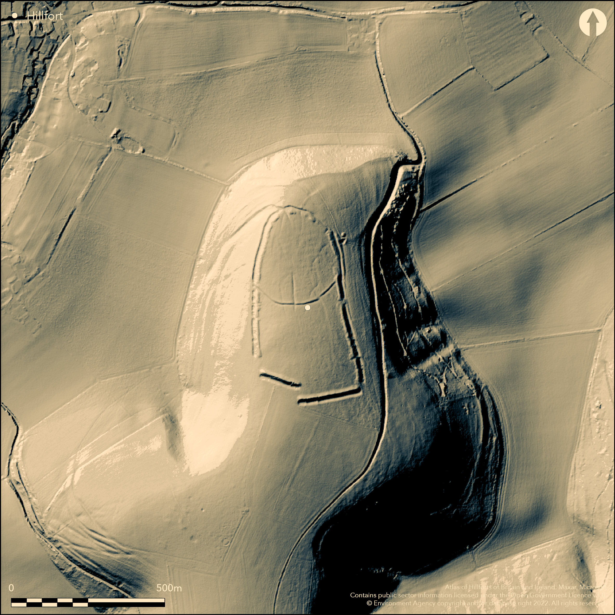
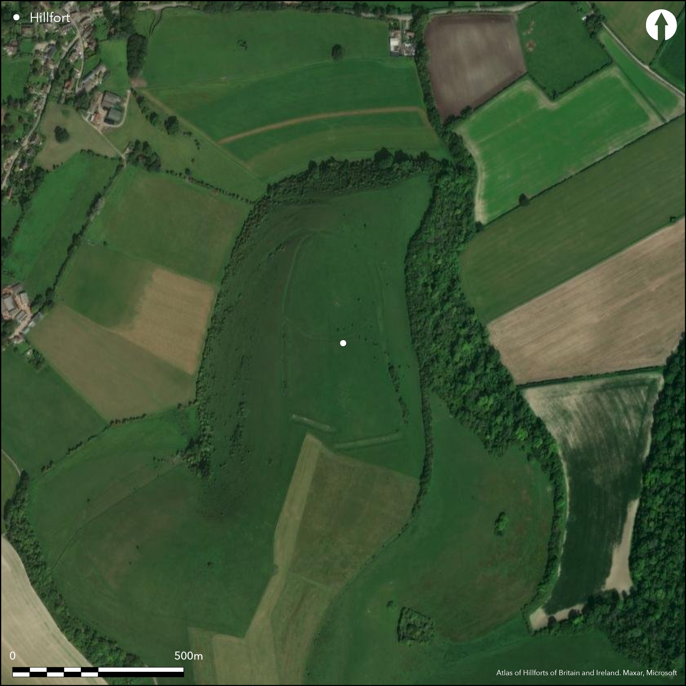
Univallate, oval, and complex partial contour hillfort located in commanding position at W end of N-facing downland spur promontory high above the Vale of Wardour in Cranborne Chase. Very steep surrounding slopes to to E, W and N, ground rising moderately to summit of Winkelbury Hill to S. Sometimes described as a promontory fort, its defences, with gaps, complete the circuit. To S two substantial bank and ditch sections; to N, W and E separate bank and ditch follow contour around the domed promontory, the E and W ramparts being not visible from centre of fort. Slighter bank and ditch bisects interior E-W creating smaller enclosure of c. 2.5ha. Cross-ridge dyke c. 500m to S of fort boundary cuts off spur, forming outer defence where the site vulnerable and approached across level ground. S rampart c. 200m in length and constructed in two separate sections, both of similar size. No attempt made to link these to main circuit. Ramparts on W, N and E sides comprise bank and external ditch with low counterscarp bank on E and N and N half of W side. Both bank and ditch appear built as series of sections, with many interruptions in the ditch located opposite gaps in bank. This may be deliberate, size of main outward-facing scarp suggesting that unusual form of ramparts not the result of being left in unfinished state. There could be suggestions of gang working here. The inner rampart, bisecting interior, possibly later than main defensive circuit, seen on W side where bank and ditch overlie rampart. Construction of later rampart possibly result of recutting the ditch of main defences at N end of fort, possibly accounting for more regular composition of the defences at this end. Wide gaps at E and W ends of S rampart sections suggest that possible earlier cross-dyke to cut off the promontory followed by later completion of the circuit to N. Entrance on N apex post-dates the rampart. However, may belong to later phase, possibly associated with the bisecting inner rampart. There are two simple gaps in the bank and ditch bisecting the site which may be original. Indications of hut circles and pits are present within the interior. Excavated by Pitt-Rivers 1881-82, who sectioned the ramparts in four places and hollow-way running across fort, finding six refuse pits and site of hut with remains of wattle and daub, early to middle Iron Age material. Prehistoric field systems outside N end of fort. General good condition. On Ist Ed. OS map (1887).
Citizen Science: ✓
Reliability of Data: Confirmed
Reliability of Interpretation: Confirmed
X: -230370 Y: 6620370 (EPSG: 3857)
Longitude: -2.0694491257403436 Latitude: 50.99477680601681 (EPSG:4326)
Country: England
Current County or Unitary Authority: Wiltshire
Historic County: Wiltshire
Current Parish/Community/Council/Townland: Berwick St John
General good condition. SSSI.
| Extant | ✓ |
| Cropmark | ✗ |
| Likely Destroyed | ✗ |
Downland pasture.
| Woodland | ✗ |
| Commercial Forestry Plantation | ✗ |
| Parkland | ✗ |
| Pasture (Grazing) | ✓ |
| Arable | ✗ |
| Scrub/Bracken | ✗ |
| Bare Outcrop | ✗ |
| Heather/Moorland | ✗ |
| Heath | ✗ |
| Built-up | ✗ |
| Coastal Grassland | ✗ |
| Other | ✗ |
Univallate, oval, partial contour hillfort located in commanding position at W end of N-facing downland spur promontory high above the Vale of Wardour in Cranborne Chase. Very steep surrounding slopes to to E, W and N, ground rising moderately to summit of Winkelbury Hill to S. Although sometimes described as a promontory fort, its defences, with gaps, complete the circuit.
| Contour Fort | ✗ |
| Partial Contour Fort | ✓ |
| Promontory Fort | ✗ |
| Hillslope Fort | ✗ |
| Level Terrain Fort | ✗ |
| Marsh Fort | ✗ |
| Multiple Enclosure Fort | ✗ |
Located on a dsteep downland spur facing north high above the Vale of Wardour in Cranborne Chase
| Hilltop | ✗ |
| Coastal Promontory | ✗ |
| Inland Promontory | ✓ |
| Valley Bottom | ✗ |
| Knoll/Hillock/Outcrop | ✗ |
| Ridge | ✗ |
| Cliff/Plateau-edge/Scarp | ✗ |
| Hillslope | ✗ |
| Lowland | ✗ |
| Spur | ✓ |
Dominant Topographic Feature: Downland spur promontory.
| North | ✓ |
| Northeast | ✗ |
| East | ✗ |
| Southeast | ✗ |
| South | ✗ |
| Southwest | ✗ |
| West | ✗ |
| Northwest | ✗ |
| Level | ✗ |
Altitude: 240.0m
N/A
Pitt Rivers found early to middle Iron Age material and a few Romano-British finds. Number of flint implements or flakes, some underlying earliest defences. Late Bronze Age chisel-bladed tracer also found. Finds in the Pitt-Rivers Museum, Farnham, Dorset.
Reliability: C - Low
| Pre 1200BC | ✗ |
| 1200BC - 800BC | ✗ |
| 800BC - 400BC | ✓ |
| 400BC - AD50 | ✓ |
| AD50 - AD400 | ✓ |
| AD400 - AD 800 | ✗ |
| Post AD800 | ✗ |
| Unknown | ✗ |
| Pre Hillfort: | None |
| Post Hillfort: | None |
| Artefactual: | None |
In Aubrey's Monumenta Britannica (1665-1693). On Ist Ed. OS map (1887). Excavated by Pitt-Rivers 1881-82. Measured survey RCHME: South Wiltshire Project, ref. no. 831573.
| 1st Identified Map Depiction (1887): | OS map. |
| Earthwork Survey (1991): | Measured survey RCHME: South Wiltshire Project. |
| 1st Identified Written Reference (None): | Aubrey's Monumenta Britannica. |
| Excavation (None): | Pitt Rivers excavation. |
Pitt Rivers excavated six shallow depressions in turf of interior of fort and found to be Iron Age refuse pits. Basin shaped pit on E side surrounded by bank on the lower side was site of a hut with remains of timbering and wattle and daub. Pitt-Rivers made a mound near it with the excavated soil and thatched over the pit to preserve it. Pitt Rivers found early to middle Iron Age material and a few Romano-British finds. Number of flint implements or flakes, some underlying earliest defences. Late Bronze Age chisel-bladed tracer also found. Quarry hollows.
None
| None | ✓ |
| Spring | ✗ |
| Stream | ✗ |
| Pool | ✗ |
| Flush | ✗ |
| Well | ✗ |
| Other | ✗ |
Indications of hut circles and pits are present within the interior. Quarry hollows.
| No Known Features | ✗ |
| Round Stone Structures | ✗ |
| Rectangular Stone Structures | ✗ |
| Curvilinear Platforms | ✗ |
| Other Roundhouse Evidence | ✓ |
| Pits | ✓ |
| Quarry Hollows | ✓ |
| Other | ✓ |
Pitt Rivers excavated six shallow depressions in turf of interior of fort and found to be Iron Age refuse pits. Basin shaped pit on E side surrounded by bank on the lower side was site of a hut with remains of timbering and wattle and daub. Pitt-Rivers made a mound near it with the excavated soil and thatched over the pit to preserve it. He suggested depressions and pits to be 'pit dwellings'.
| No Known Excavation | ✗ |
| Pits | ✓ |
| Postholes | ✗ |
| Roundhouses | ✓ |
| Rectangular Structures | ✗ |
| Roads/Tracks | ✗ |
| Quarry Hollows | ✗ |
| Other | ✓ |
| Nothing Found | ✗ |
None
| No Known Geophysics | ✓ |
| Pits | ✗ |
| Roundhouses | ✗ |
| Rectangular Structures | ✗ |
| Roads/Tracks | ✗ |
| Quarry Hollows | ✗ |
| Other | ✗ |
| Nothing Found | ✗ |
Pitt Rivers found early to middle Iron Age material and a few Romano-British finds. Wattle and daub. Number of flint implements or flakes, some underlying earliest defences. Late Bronze Age chisel-bladed tracer also found. Finds in the Pitt-Rivers Museum, Farnham, Dorset.
| No Known Finds | ✗ |
| Pottery | ✓ |
| Metal | ✓ |
| Metalworking | ✗ |
| Human Bones | ✗ |
| Animal Bones | ✗ |
| Lithics | ✓ |
| Environmental | ✗ |
| Other | ✓ |
None
| APs Not Checked | ✓ |
| None | ✗ |
| Roundhouses | ✗ |
| Rectangular Structures | ✗ |
| Pits | ✗ |
| Postholes | ✗ |
| Roads/Tracks | ✗ |
| Other | ✗ |
Passage entrance on N apex post-dates the rampart. However, may belong to later phase, possibly associated with the bisecting inner rampart. There are two simple gaps in the bank and ditch bisecting interior which may be original. To S breaks in ramparts associated with position of ramparts vis a vis circuit rather than entrance gaps per se. It is possible that some of these gaps might be original, but have not been determined.
| 9: | Nine desk estimated gaps. To S breaks in ramparts associated with position of ramparts vis a vis circuit rather than entrance gaps per se. It is possible that some of these gaps might be original, but not defined. |
| 2: | None |
Guard Chambers: ✗
Chevaux de Frise: ✗
| 1. Passage-way/Corridor (North): | Located at N apex. |
| 2. Simple Gap (South): | In bank bisecting interior. |
| 3. Simple Gap (South): | In bank bisecting interior. |
To S two substantial bank and ditch sections; to N, W and E separate bank and ditch follow contour around the domed promontory, the E and W ramparts being not visible from centre of fort. Slighter bank and ditch bisects interior E-W creating smaller enclosure of c. 2.5ha. S rampart c. 200m in length and constructed in two separate sections, both of similar size. No attempt made to link these to main circuit. Ramparts on W, N and E sides comprise bank and external ditch with low counterscarp bank on E and N and N half of W side. Both bank and ditch appear built as series of sections, with many interruptions in the ditch located opposite gaps in bank. This may be deliberate, size of main outward-facing scarp suggesting that unusual form of ramparts not the result of being left in unfinished state. There could be suggestions of gang working here. The inner rampart, bisecting interior, possibly later than main defensive circuit, seen on W side where bank and ditch overlie rampart. Construction of later rampart possibly result of recutting the ditch of main defences at N end of fort, possibly accounting for more regular composition of the defences at this end. Wide gaps at E and W ends of S rampart sections suggest that possible earlier cross-dyke to cut off the promontory followed by later completion of the circuit to N.
| Area 1: | 6.0ha. |
| Total: | 6.0ha. |
Total Footprint Area: Noneha.
None
| ✓ | Possibly phased. Wide gaps at E and W ends of S rampart sections suggest that possible earlier cross-dyke to cut off the promontory followed by later completion of the circuit to N. |
| ✓ | None |
| NE Quadrant: | 1 |
| SE Quadrant: | 1 |
| SW Quadrant: | 1 |
| NW Quadrant: | 1 |
| Total: | 1 |
| Partial Univallate | ✗ |
| Univallate | ✓ |
| Partial Bivallate | ✗ |
| Bivallate | ✗ |
| Partial Multivallate | ✗ |
| Multivallate | ✗ |
| Unknown | ✗ |
| Partial Univallate | ✗ |
| Univallate | ✗ |
| Partial Bivallate | ✗ |
| Bivallate | ✗ |
| Partial Multivallate | ✗ |
| Multivallate | ✗ |
Cross-ridge dyke c. 500m to S of fort boundary cuts off spur, forming outer defence where the site vulnerable and approached across level ground. Low counterscarp bank on E and N and N half of W side. Both bank and ditch appear built as series of sections, with many interruptions in the ditch located opposite gaps in bank. This may be deliberate, size of main outward-facing scarp suggesting that unusual form of ramparts not the result of being left in unfinished state. There could also be suggestions of gang working here.
| None | ✗ |
| Earthen Bank | ✓ |
| Stone Wall | ✗ |
| Rubble | ✗ |
| Wall-walk | ✗ |
| Evidence of Timber | ✗ |
| Vitrification | ✗ |
| Other Burning | ✗ |
| Palisade | ✗ |
| Counter Scarp Bank | ✓ |
| Berm | ✗ |
| Unfinished | ✓ |
| Other | ✓ |
Excavated by Pitt-Rivers 1881-82, who sectioned the ramparts in four places and hollow-way running across fort, finding six refuse pits and site of hut with remains of wattle and daub, early to middle Iron Age material.
| None | ✗ |
| Earthen Bank | ✓ |
| Stone Wall | ✗ |
| Murus Duplex | ✗ |
| Timber-framed | ✗ |
| Timber-laced | ✗ |
| Vitrification | ✗ |
| Other Burning | ✗ |
| Palisade | ✗ |
| Counter Scarp Bank | ✗ |
| Berm | ✗ |
| Unfinished | ✗ |
| No Known Excavation | ✗ |
| Other | ✓ |
| ✓ | There could be suggestions of gang working to S. Both bank and ditch appear built as series of sections, with many interruptions in the ditch located opposite gaps in bank. This may be deliberate, size of main outward-facing scarp suggesting that unusual form of ramparts not the result of being left in unfinished state. There could also be suggestions of gang working here. |
| ✓ | None |
Number of Ditches: 1
| ✗ | None |
Jesson, M. and Hill, D. 1971. The Iron Age and its hill-forts, Southampton University, 32.
Pitt Rivers, A.H.L.F. 1888, Excavations on Cranborne Chase, 2, 233-53.
Pugh, R.B. and Crittall, E. eds 1957. A history of Wiltshire, 1.1, The Victoria history of the counties of England, Oxford: OUP, 265.
Atlas of Hillforts:
Wikidata:
This work is licensed under CC BY-SA 4.0![]()
![]()
![]() and should be cited as:
and should be cited as:
Lock, Gary and Ralston, Ian. 2024. Atlas of Hillforts of Britain and Ireland. Available at: https://hillforts.arch.ox.ac.uk
Document Version 1.1