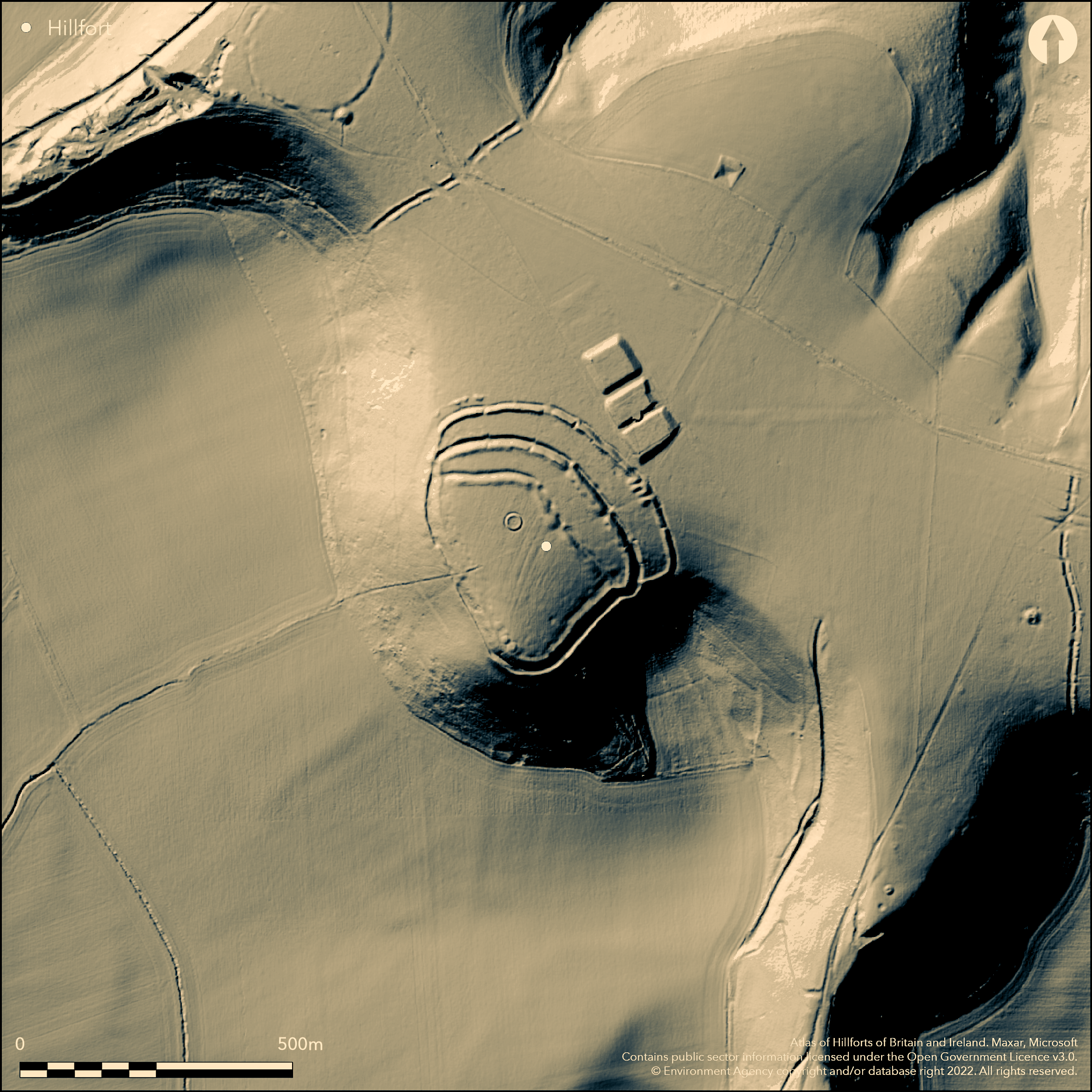
LiDAR 1m DTM Hillshade
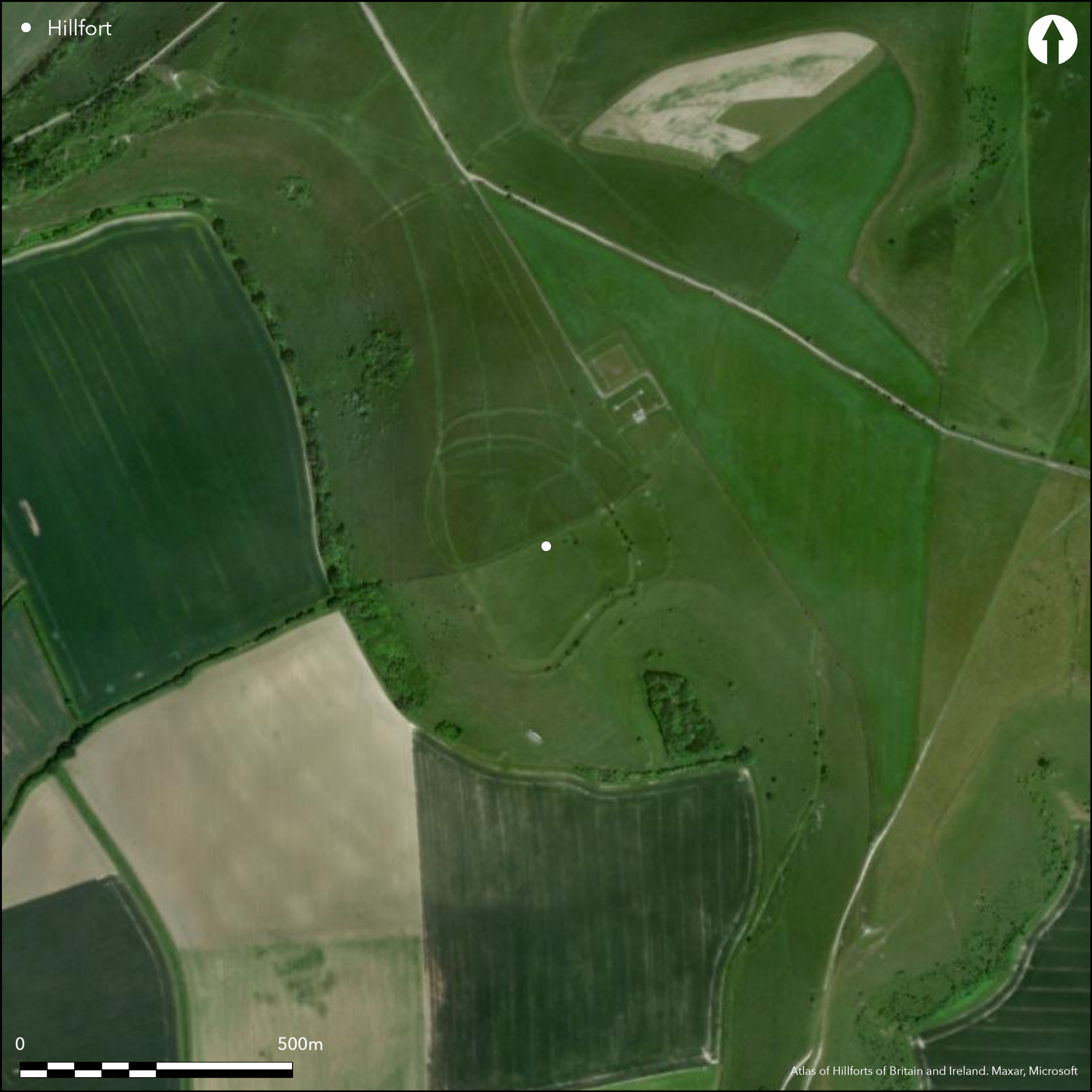
Satellite Imagery
LiDAR 1m DTM Hillshade
Satellite Imagery
Scroll left/right to view further images.
HER: Wiltshire and Swindon MWI1719 (None)
NMR: ST 83 SW 7 (207206)
SM: 1005690
NGR: ST80423460
X: 380429 Y: 134602 (OSGB36)
Complex contour hillfort occupying prominent edge of chalk escarpment overlooking low lying clay vale to S and W. Approached over level terrain from N and E. Univallate on S and W, crowning steep escarpment. Multivallate on N and E, facing plateau, enclosing 5.7ha. In superb strategic position. Fort thought to be of two main phases, initially a univallate enclosure bounded by the innermost rampart. Second phase construction of middle and most E rampart, still with its original entrances. To S and W sides, where defence least needed, site defined by ledge into which ditch irregularly excavated. Intermittent traces of counterscarp bank present. Although no proper rampart structure survives here, ledge when viewed from exterior creates impression of monumentality from below. For much of S and W circuit there is an internal quarry scoop. Innermost element of trivallate complex appears incomplete or slighted and constructed in three separate sections, the rampart being discontinuous and ditch incomplete, especially in middle section where it consists of series of elongated hollows. Middle defences similarly composed of three individual segments, though, in this case, boundary intact. Two simple gap entrances in the circuit of which only one, to N, appears original. This rampart possibly part of the original circuit of the enclosure. Outer defences similarly interrupted and consist of at least seven component parts, with narrow external ditch. Well-preserved double portal entrance arrangement in this outer circuit to NE, consisting of two gaps c. 3m-5m wide separated by a distance of c. 10m. Each has internally flanked carriageway c. 10m long. Dumps of material outside NW corner of site could be unfinished fourth bank. Wide berms possibly densely settled, with sub-circular hollows and platforms within middle and outer bank to SE. Small 19th century excavation, probably Iron Age based on morphology. Two earlier round barrows incorporated in circuit plus evidence of other structures. On Ist Ed. OS map (1887).
Citizen Science: ✗
Reliability of Data: Confirmed
Reliability of Interpretation: Confirmed
X: -253916 Y: 6640831 (EPSG: 3857)
Longitude: -2.280968433205794 Latitude: 51.11031722707438 (EPSG:4326)
Country: England; None
Current County or Unitary Authority: Wiltshire
Historic County: Wiltshire
Current Parish/Community/Council/Townland: Stourton with Gasper; Kilmington; Mere.
Much of interior scarred by ridge and furrow possibly accounting for damage to inner circuit. Numerous circular platforms up to 12m wide survive on the periphery of this ploughing.
| Extant | ✓ |
| Cropmark | ✗ |
| Likely Destroyed | ✗ |
SSSI.
| Woodland | ✗ |
| Commercial Forestry Plantation | ✗ |
| Parkland | ✗ |
| Pasture (Grazing) | ✓ |
| Arable | ✗ |
| Scrub/Bracken | ✗ |
| Bare Outcrop | ✗ |
| Heather/Moorland | ✗ |
| Heath | ✗ |
| Built-up | ✗ |
| Coastal Grassland | ✗ |
| Other | ✗ |
Complex contour hillfort occupying prominent edge of chalk escarpment overlooking low lying clay vale to S and W. Superb strategic position.
| Contour Fort | ✓ |
| Partial Contour Fort | ✗ |
| Promontory Fort | ✗ |
| Hillslope Fort | ✗ |
| Level Terrain Fort | ✗ |
| Marsh Fort | ✗ |
| Multiple Enclosure Fort | ✗ |
| Hilltop | ✓ |
| Coastal Promontory | ✗ |
| Inland Promontory | ✗ |
| Valley Bottom | ✗ |
| Knoll/Hillock/Outcrop | ✗ |
| Ridge | ✗ |
| Cliff/Plateau-edge/Scarp | ✗ |
| Hillslope | ✗ |
| Lowland | ✗ |
| Spur | ✗ |
Dominant Topographic Feature: Chalk escarpment.
| North | ✗ |
| Northeast | ✗ |
| East | ✗ |
| Southeast | ✗ |
| South | ✗ |
| Southwest | ✗ |
| West | ✗ |
| Northwest | ✗ |
| Level | ✓ |
Altitude: 245.0m
Three parishes on site.
Boundary Type: Parish/Townland
Probably Iron Age based on morphology.
Reliability: D - None
| Pre 1200BC | ✗ |
| 1200BC - 800BC | ✗ |
| 800BC - 400BC | ✓ |
| 400BC - AD50 | ✓ |
| AD50 - AD400 | ✗ |
| AD400 - AD 800 | ✗ |
| Post AD800 | ✗ |
| Unknown | ✗ |
| Pre Hillfort: | None |
| Post Hillfort: | None |
| Morphology/Earthwork/Typology: | Estimated. |
In Aubrey's Monumenta Britannica (1665-1693). On Ist Ed. OS map (1887). 1800-1810 excavation W. Cunnington Sen. 1992 Geophysical survey. Measured survey RCHME undated.
| 1st Identified Map Depiction (1887): | OS map. |
| Geophysical Survey (1992): | Geophysical surveys of Bradford. |
| 1st Identified Written Reference (None): | Aubrey's Monumenta Britannica. |
| Excavation (None): | W. Cunnington Sen. |
| Other (None): | Measured survey RCHME. |
Sub-circular hollows and platforms within middle and outer bank to SE. For much of S and W circuit there is an internal quarry scoop.
None
| None | ✓ |
| Spring | ✗ |
| Stream | ✗ |
| Pool | ✗ |
| Flush | ✗ |
| Well | ✗ |
| Other | ✗ |
Sub-circular hollows and platforms within middle and outer bank to SE. For much of S and W circuit there is an internal quarry scoop.
| No Known Features | ✗ |
| Round Stone Structures | ✗ |
| Rectangular Stone Structures | ✗ |
| Curvilinear Platforms | ✓ |
| Other Roundhouse Evidence | ✗ |
| Pits | ✗ |
| Quarry Hollows | ✓ |
| Other | ✗ |
None
| No Known Excavation | ✗ |
| Pits | ✗ |
| Postholes | ✗ |
| Roundhouses | ✗ |
| Rectangular Structures | ✗ |
| Roads/Tracks | ✗ |
| Quarry Hollows | ✗ |
| Other | ✗ |
| Nothing Found | ✓ |
None
| No Known Geophysics | ✓ |
| Pits | ✗ |
| Roundhouses | ✗ |
| Rectangular Structures | ✗ |
| Roads/Tracks | ✗ |
| Quarry Hollows | ✗ |
| Other | ✗ |
| Nothing Found | ✗ |
None
| No Known Finds | ✓ |
| Pottery | ✗ |
| Metal | ✗ |
| Metalworking | ✗ |
| Human Bones | ✗ |
| Animal Bones | ✗ |
| Lithics | ✗ |
| Environmental | ✗ |
| Other | ✗ |
None
| APs Not Checked | ✓ |
| None | ✗ |
| Roundhouses | ✗ |
| Rectangular Structures | ✗ |
| Pits | ✗ |
| Postholes | ✗ |
| Roads/Tracks | ✗ |
| Other | ✗ |
On NE quadrant, facing plateau, entrance gaps in outer, middle and inner ramparts, perhaps not all original. inner gaps indeterminate; middle and most E rampart still with its original entrances. Well preserved double portal entrance arrangement in outer circuit to NE, consisting of two gaps c. 3m-5m wide separated by a distance of c. 10m. Each has internally flanked carriageway c. 10m long.
| 6: | Six NE gaps to outer rampart; two original. Middle rampart on NE two gaps, one original. Inner rampart has two NE gaps, originality not determined. Assumed gaps in middle and inner ramparts part of total entrance complex, but difficult to interpret. |
| 2: | None |
Guard Chambers: ✗
Chevaux de Frise: ✗
| 1. In-turned (North east): | Part of outer double-portal entrance. |
| 1. Other Forms (North east): | Middle rampart on NE two gaps, one original. Inner rampart has two NE gaps, originality not determined. Assumed gaps in middle and inner ramparts part of total entrance complex, but difficult to interpret. |
| 1. Passage-way/Corridor (North east): | Each has internally flanked carriageway c. 10m long. |
Univallate on S and W, crowning steep escarpment. Multivallate on N and E, facing plateau.
| Area 1: | 5.7ha. |
| Total: | 5.7ha. |
Total Footprint Area: Noneha.
None
| ✓ | Fort thought to be of two main phases, initially a univallate enclosure bounded by the innermost rampart. Second phase construction of middle and most E rampart, still with its original entrances. |
| ✓ | SE quadrant has three ramparts to N and one to S. |
| NE Quadrant: | 3 |
| SE Quadrant: | 3 |
| SW Quadrant: | 1 |
| NW Quadrant: | 3 |
| Total: | 3 |
| Partial Univallate | ✓ |
| Univallate | ✗ |
| Partial Bivallate | ✗ |
| Bivallate | ✗ |
| Partial Multivallate | ✓ |
| Multivallate | ✗ |
| Unknown | ✗ |
| Partial Univallate | ✗ |
| Univallate | ✓ |
| Partial Bivallate | ✗ |
| Bivallate | ✗ |
| Partial Multivallate | ✗ |
| Multivallate | ✗ |
To S and W sides, where defence least needed, site defined by ledge into which ditch irregularly excavated. Intermittent traces of counterscarp bank present. Although no proper rampart structure survives here, ledge when viewed from exterior creates impression of monumentality from below. Wide berms. Dumps of material outside NW corner of site could be unfinished fourth bank.
| None | ✗ |
| Earthen Bank | ✓ |
| Stone Wall | ✗ |
| Rubble | ✗ |
| Wall-walk | ✗ |
| Evidence of Timber | ✗ |
| Vitrification | ✗ |
| Other Burning | ✗ |
| Palisade | ✗ |
| Counter Scarp Bank | ✓ |
| Berm | ✓ |
| Unfinished | ✓ |
| Other | ✓ |
None
| None | ✗ |
| Earthen Bank | ✗ |
| Stone Wall | ✗ |
| Murus Duplex | ✗ |
| Timber-framed | ✗ |
| Timber-laced | ✗ |
| Vitrification | ✗ |
| Other Burning | ✗ |
| Palisade | ✗ |
| Counter Scarp Bank | ✗ |
| Berm | ✗ |
| Unfinished | ✗ |
| No Known Excavation | ✓ |
| Other | ✗ |
| ✗ | None |
| ✓ | None |
Number of Ditches: 3
| ✗ | None |
Geophysical Surveys of Bradford 1995. Whitesheet Hill, Wiltshire, Geophysical Surveys of Bradford Reports Survey No: 92/95, Bradford.
Hoare, R.C. 1812, The ancient history of Wiltshire, 1, London: Miller, 43.
Pugh, R.B. and Crittall, E. eds 1957. A history of Wiltshire, 1.1, The Victoria history of the counties of England, Oxford: OUP, 87.
Atlas of Hillforts:
Wikidata:
This work is licensed under CC BY-SA 4.0![]()
![]()
![]() and should be cited as:
and should be cited as:
Lock, Gary and Ralston, Ian. 2024. Atlas of Hillforts of Britain and Ireland. Available at: https://hillforts.arch.ox.ac.uk
Document Version 1.1