LiDAR 1m DTM Hillshade
Satellite Imagery
LiDAR 1m DTM Hillshade
Satellite Imagery
Scroll left/right to view further images.
HER: Wiltshire and Swindon MWI1230 (None)
NMR: ST 84 SW 1 (207638)
SM: 1017296
NGR: ST83884489
X: 383887 Y: 144895 (OSGB36)
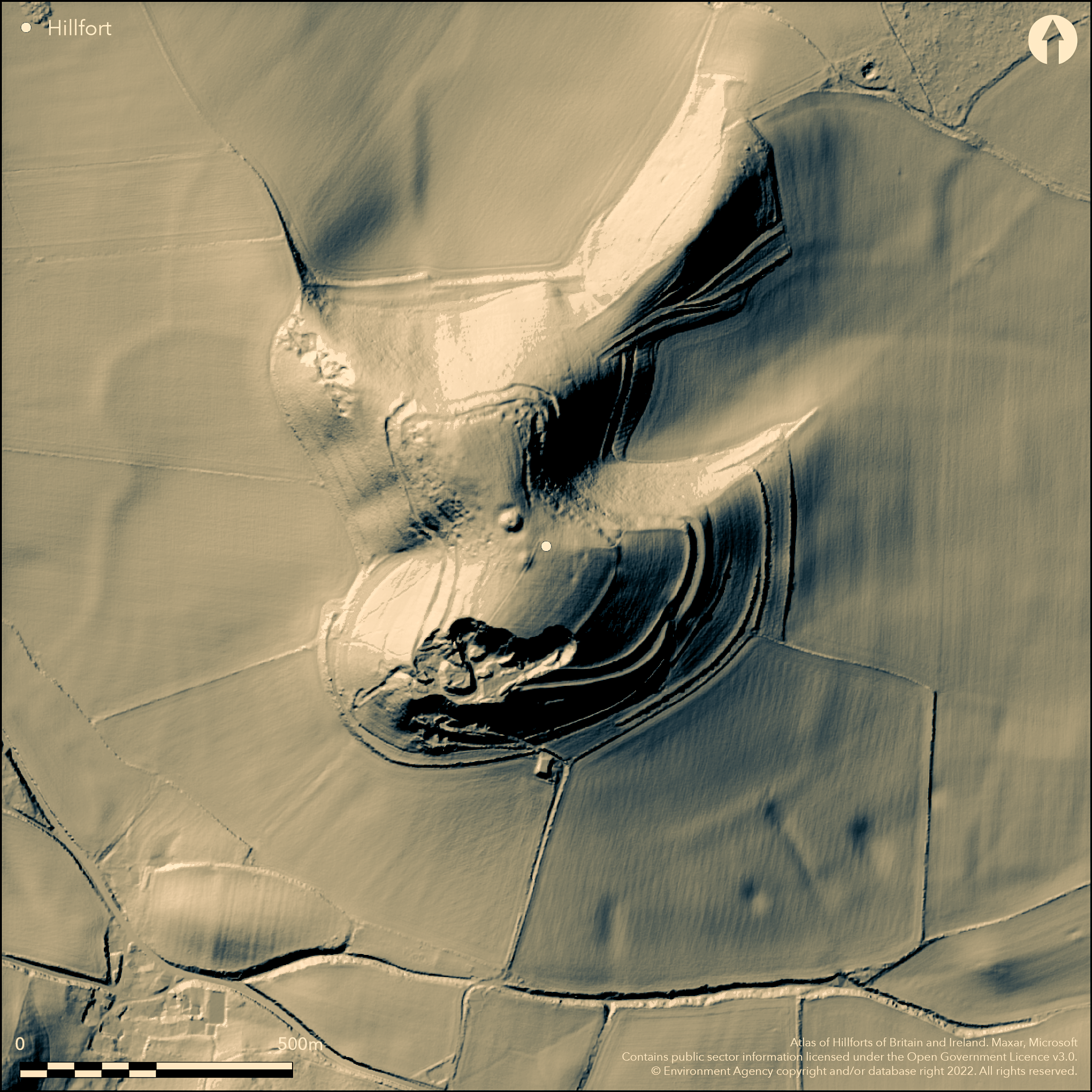
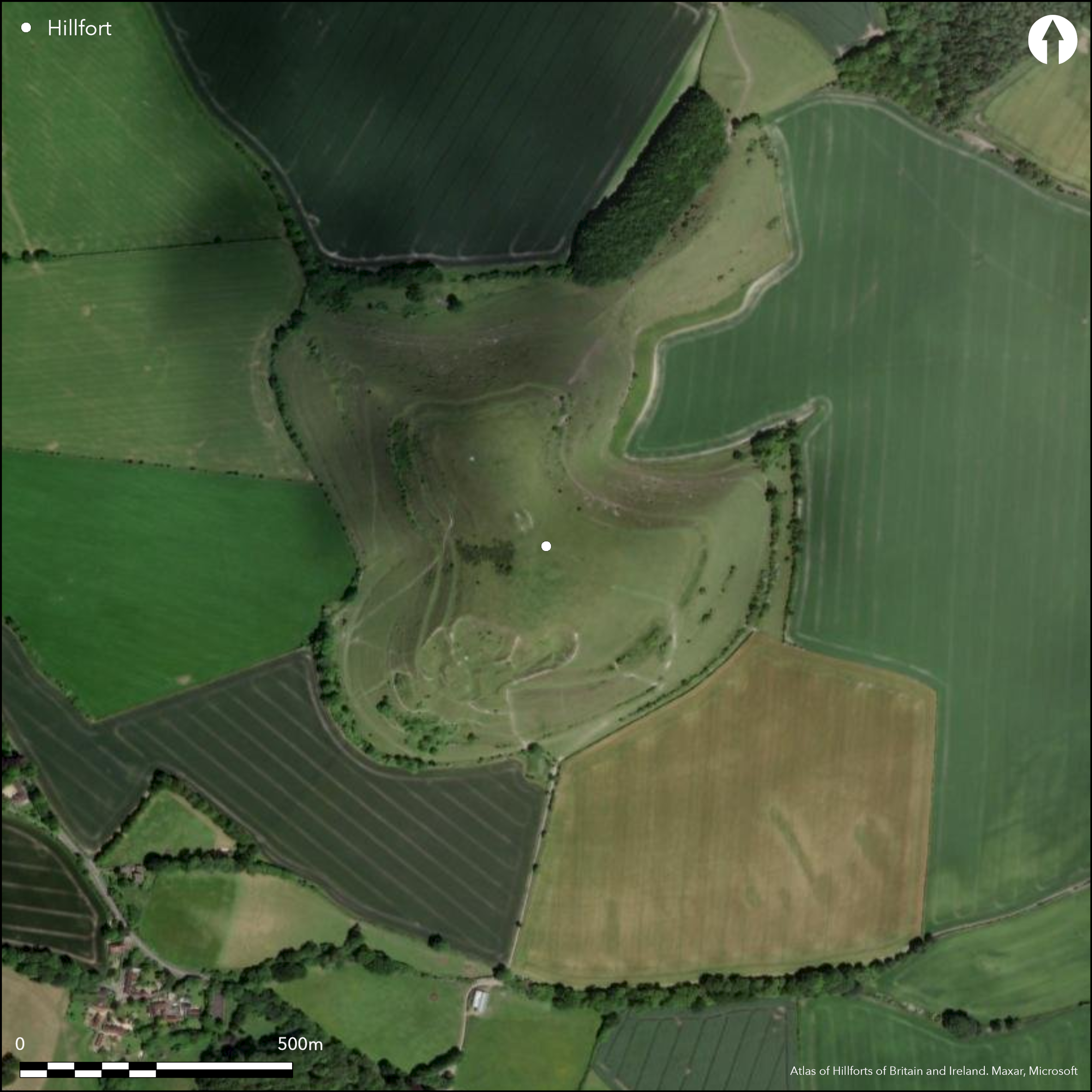
Univallate contour hillfort occupying a steep sided outlier of Middle and Upper Chalk, c. 3km W of W edge of Salisbury Plain. Defences complex and much disturbed and lost through quarrying, slumping and ploughing. Internal area 6.9ha. Rampart survives now as external facing bank 2.5m high best-preserved on W side. Here separated from a counterscarp by a berm 5m-10m wide. On this berm traces of original ditch. SW section has been quarried away by large chalk quarry cutting into hillside destroying rampart. No obvious original entrance, but possible entrance gap 10m wide visible in denuded rampart on E side. Internal quarry scoop immediately within hillfort interior. Post medieval boundary bank c. 1m wide and 0.5m high, aligned roughly NE-SW in interior. To the SE of hillfort, 50m downslope, two medieval strip lynchets damaged by quarrying. Suggested that they may be re-using an earlier, pre-existing, boundary which formed a hillfort annexe. Aerial Photographs taken 1975-7 suggest that the possible annexe interior, between hillfort and these strip lynchets, contains many house platforms and pits. Flat-topped bowl barrow on summit and another to SSE excavated by W. Cunnington Sen. in early 19th century. Probably Iron Age based on morphology. On Ist Ed. OS map (1887).
Citizen Science: ✓
Reliability of Data: Confirmed
Reliability of Interpretation: Confirmed
X: -248469 Y: 6657278 (EPSG: 3857)
Longitude: -2.232035242250795 Latitude: 51.202981233769975 (EPSG:4326)
Country: England
Current County or Unitary Authority: Wiltshire
Historic County: Wiltshire
Current Parish/Community/Council/Townland: Corsley
SW section has been quarried away by large chalk quarry cutting into hillside destroying rampart. Elsewhere ramparts denuded and interior ploughed in past. SSSI. On Heritage at Risk Register (2015).
| Extant | ✓ |
| Cropmark | ✗ |
| Likely Destroyed | ✓ |
Cultivated interior in past. Quarry.
| Woodland | ✗ |
| Commercial Forestry Plantation | ✗ |
| Parkland | ✗ |
| Pasture (Grazing) | ✓ |
| Arable | ✓ |
| Scrub/Bracken | ✗ |
| Bare Outcrop | ✗ |
| Heather/Moorland | ✗ |
| Heath | ✗ |
| Built-up | ✗ |
| Coastal Grassland | ✗ |
| Other | ✓ |
Univallate contour hillfort occupying a steep sided outlier of Middle and Upper Chalk c. 3km W of the W edge of Salisbury Plain.
| Contour Fort | ✓ |
| Partial Contour Fort | ✗ |
| Promontory Fort | ✗ |
| Hillslope Fort | ✗ |
| Level Terrain Fort | ✗ |
| Marsh Fort | ✗ |
| Multiple Enclosure Fort | ✗ |
| Hilltop | ✓ |
| Coastal Promontory | ✗ |
| Inland Promontory | ✗ |
| Valley Bottom | ✗ |
| Knoll/Hillock/Outcrop | ✗ |
| Ridge | ✗ |
| Cliff/Plateau-edge/Scarp | ✗ |
| Hillslope | ✗ |
| Lowland | ✗ |
| Spur | ✗ |
Dominant Topographic Feature: Outlier of Middle and Upper Chalk.
| North | ✗ |
| Northeast | ✗ |
| East | ✗ |
| Southeast | ✗ |
| South | ✗ |
| Southwest | ✗ |
| West | ✗ |
| Northwest | ✗ |
| Level | ✓ |
Altitude: 240.0m
N/A
Probably Iron Age based on morphology. Two round barrows in the interior.
Reliability: C - Low
| Pre 1200BC | ✗ |
| 1200BC - 800BC | ✗ |
| 800BC - 400BC | ✓ |
| 400BC - AD50 | ✓ |
| AD50 - AD400 | ✗ |
| AD400 - AD 800 | ✗ |
| Post AD800 | ✗ |
| Unknown | ✗ |
| Pre Hillfort: | None |
| Post Hillfort: | None |
| Morphology/Earthwork/Typology: | Estimated. |
In Aubrey's Monumenta Britannica (1665-1693). On Ist Ed. OS map (1887). Bowl barrow on summit and another to SSE part excavated by Colt Hoare and Cunnington in early 19th century finding traces of wheat and burnt bone. Measured survey RCHME South Wiltshire Project, ref. no. 831573. LiDAR (Citizen Science, no details)
| 1st Identified Map Depiction (1887): | OS map. |
| 1st Identified Written Reference (None): | Aubrey's Monumenta Britannica. |
| Earthwork Survey (None): | Measured survey RCHME South Wiltshire Project. |
| Excavation (None): | Bowl barrow on summit and another to SSE part excavated by W. Cunnington Sen. |
| LiDAR Survey (None): | Citizen Science |
Aerial Photographs taken 1975-7 suggest that the possible annexe interior, between hillfort and strip lynchets to SE, contains many house platforms and pits. Internal quarry scoop immediately within hillfort interior.
None
| None | ✓ |
| Spring | ✗ |
| Stream | ✗ |
| Pool | ✗ |
| Flush | ✗ |
| Well | ✗ |
| Other | ✗ |
Internal quarry scoop immediately within hillfort interior.
| No Known Features | ✗ |
| Round Stone Structures | ✗ |
| Rectangular Stone Structures | ✗ |
| Curvilinear Platforms | ✗ |
| Other Roundhouse Evidence | ✗ |
| Pits | ✗ |
| Quarry Hollows | ✓ |
| Other | ✗ |
None
| No Known Excavation | ✓ |
| Pits | ✗ |
| Postholes | ✗ |
| Roundhouses | ✗ |
| Rectangular Structures | ✗ |
| Roads/Tracks | ✗ |
| Quarry Hollows | ✗ |
| Other | ✗ |
| Nothing Found | ✗ |
None
| No Known Geophysics | ✓ |
| Pits | ✗ |
| Roundhouses | ✗ |
| Rectangular Structures | ✗ |
| Roads/Tracks | ✗ |
| Quarry Hollows | ✗ |
| Other | ✗ |
| Nothing Found | ✗ |
None
| No Known Finds | ✓ |
| Pottery | ✗ |
| Metal | ✗ |
| Metalworking | ✗ |
| Human Bones | ✗ |
| Animal Bones | ✗ |
| Lithics | ✗ |
| Environmental | ✗ |
| Other | ✗ |
Aerial Photographs taken 1975-7 suggest that the possible annexe interior, between hillfort and strip lynchets to SE, contains many house platforms and pits.
| APs Not Checked | ✗ |
| None | ✗ |
| Roundhouses | ✓ |
| Rectangular Structures | ✗ |
| Pits | ✓ |
| Postholes | ✗ |
| Roads/Tracks | ✗ |
| Other | ✗ |
No obvious original entrance, but SW section has been quarried away by large chalk quarry cutting into hillside destroying rampart, however possible entrance gap 10m wide visible in denuded rampart on E side.
| 1: | None |
| 2: | None |
Guard Chambers: ✗
Chevaux de Frise: ✗
| 1. Simple Gap (East): | Possible entrance gap 10m wide. |
Rampart survives now as external facing bank 2.5m high best preserved on W side. Here separated from a counterscarp by a berm 5m-10m wide. On this berm traces of original ditch. SW section has been quarried away by large chalk quarry cutting into hillside destroying rampart.
| Area 1: | 6.9ha. |
| Total: | 6.9ha. |
Total Footprint Area: Noneha.
None
| ✗ | None |
| ✗ | SW side lost to quarrying. |
| NE Quadrant: | 1 |
| SE Quadrant: | 1 |
| SW Quadrant: | 0 |
| NW Quadrant: | 1 |
| Total: | 1 |
| Partial Univallate | ✓ |
| Univallate | ✗ |
| Partial Bivallate | ✗ |
| Bivallate | ✗ |
| Partial Multivallate | ✗ |
| Multivallate | ✗ |
| Unknown | ✗ |
| Partial Univallate | ✗ |
| Univallate | ✗ |
| Partial Bivallate | ✗ |
| Bivallate | ✗ |
| Partial Multivallate | ✗ |
| Multivallate | ✗ |
None
| None | ✗ |
| Earthen Bank | ✓ |
| Stone Wall | ✓ |
| Rubble | ✗ |
| Wall-walk | ✗ |
| Evidence of Timber | ✗ |
| Vitrification | ✗ |
| Other Burning | ✗ |
| Palisade | ✗ |
| Counter Scarp Bank | ✓ |
| Berm | ✓ |
| Unfinished | ✗ |
| Other | ✗ |
None
| None | ✗ |
| Earthen Bank | ✗ |
| Stone Wall | ✗ |
| Murus Duplex | ✗ |
| Timber-framed | ✗ |
| Timber-laced | ✗ |
| Vitrification | ✗ |
| Other Burning | ✗ |
| Palisade | ✗ |
| Counter Scarp Bank | ✗ |
| Berm | ✗ |
| Unfinished | ✗ |
| No Known Excavation | ✓ |
| Other | ✗ |
| ✗ | None |
| ✓ | On berm traces of original ditch. |
Number of Ditches: 1
| ✓ | To the SE of hillfort, 50m downslope, two medieval strip lynchets damaged by quarrying. Suggested that they may be re-using an earlier, pre-existing, boundary which formed a hillfort annexe. Aerial Photographs taken 1975-7 suggest that the possible annexe interior, between hillfort and these strip lynchets, contains many house platforms and pits. |
Colt Hoare, R.C. 1812. The ancient history of Wiltshire, I, London: Miller, 51.
Pugh, R.B. and Crittall, E. eds 1957. A history of Wiltshire, 1.1, The Victoria history of the counties of England, Oxford: OUP, 26.
Atlas of Hillforts:
Wikidata:
This work is licensed under CC BY-SA 4.0![]()
![]()
![]() and should be cited as:
and should be cited as:
Lock, Gary and Ralston, Ian. 2024. Atlas of Hillforts of Britain and Ireland. Available at: https://hillforts.arch.ox.ac.uk
Document Version 1.1