LiDAR 1m DTM Hillshade
Satellite Imagery
LiDAR 1m DTM Hillshade
Satellite Imagery
Scroll left/right to view further images.
HER: Wiltshire and Swindon MWI3710 (None)
NMR: ST 94 SE 2 (211305)
SM: 1010207
NGR: ST96004402
X: 396006 Y: 144042 (OSGB36)
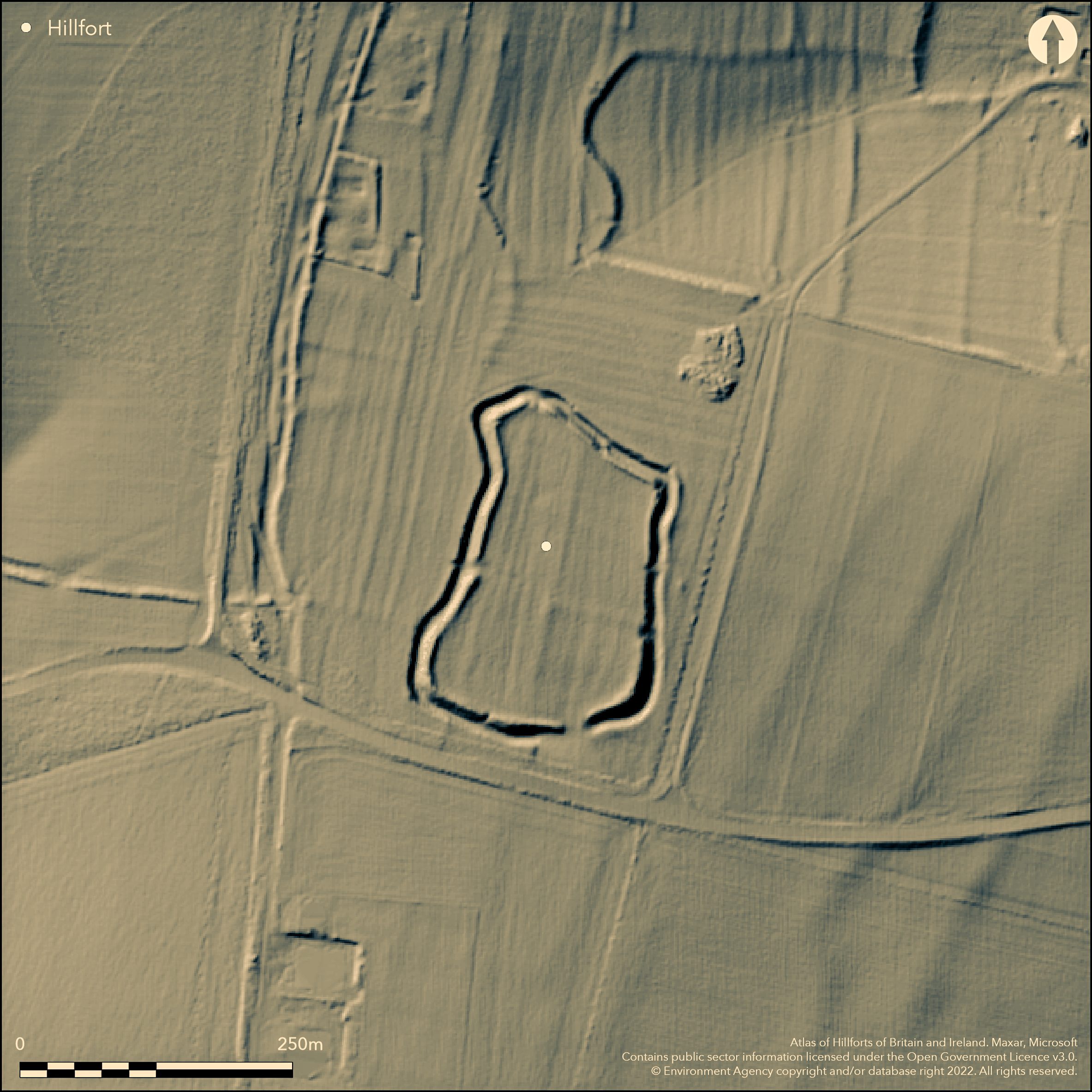
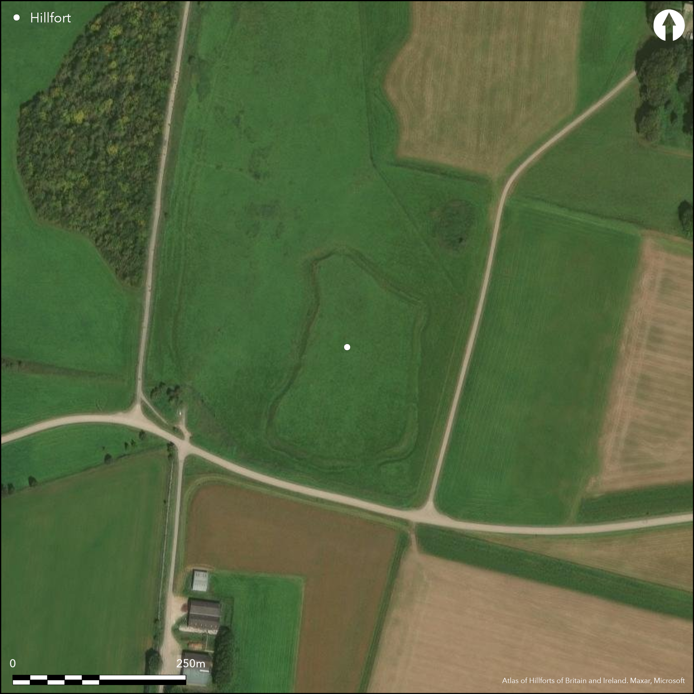
Univallate hillslope fort sited on slight SE-facing downland spur slope above the River Wylye Valley. Smallest hillfort in MOD Salisbury Plain Training Area, enclosing 1.75ha. Oval in plan, fort built on relatively level/slighltly sloping ground and akin to Casterley Camp (Atlas No 0389), lacking general topographical advantage. With substantial bank, deep and wide ditch and counterscarp (lower on E), as unusual sub-rectangular shape with concave sides and marked protuberance to the NW, result of construction on earlier field system. Best when viewed from S. Located in area of great archaeological interest on Knook Down West (see Bowden 2005, Fig 3.27), it was planned by Colt Hoare 1812 and Flinders Petrie in 1877. Evidence of Celtic fields, Romano-British settlement (to N), bowl barrow and S-shaped lynchet, all in vicinity of fort. Simple entrance on the SE side and a modern break on the W. Has been described as defensive cattle-pen associated with nearby Romano-British settlement, but clearly hillfort. Slight ridge and furrow in interior. Heavy cattle grazing damage. Undated. On Ist Ed. OS map (1887).
Citizen Science: ✓
Reliability of Data: Confirmed
Reliability of Interpretation: Confirmed
X: -229158 Y: 6655953 (EPSG: 3857)
Longitude: -2.058559054366861 Latitude: 51.19552635110344 (EPSG:4326)
Country: England
Current County or Unitary Authority: Wiltshire
Historic County: Wiltshire
Current Parish/Community/Council/Townland: Upton Lovell
Boundary features damaged by ploughing and heavy cattle grazing and ploughing removed all traces of contemporary detail within enclosure.
| Extant | ✓ |
| Cropmark | ✗ |
| Likely Destroyed | ✗ |
Downland pasture.
| Woodland | ✗ |
| Commercial Forestry Plantation | ✗ |
| Parkland | ✗ |
| Pasture (Grazing) | ✓ |
| Arable | ✗ |
| Scrub/Bracken | ✗ |
| Bare Outcrop | ✗ |
| Heather/Moorland | ✗ |
| Heath | ✗ |
| Built-up | ✗ |
| Coastal Grassland | ✗ |
| Other | ✗ |
Hillslope fort located on slight SE-facing downland spur slope above the River Wylye Valley. Although site itself relatively level, sited on slight slope, hence hillslope fort and not level terrain fort.
| Contour Fort | ✗ |
| Partial Contour Fort | ✗ |
| Promontory Fort | ✗ |
| Hillslope Fort | ✓ |
| Level Terrain Fort | ✗ |
| Marsh Fort | ✗ |
| Multiple Enclosure Fort | ✗ |
Located on the flattish plateau of Knook Down West
| Hilltop | ✗ |
| Coastal Promontory | ✗ |
| Inland Promontory | ✗ |
| Valley Bottom | ✗ |
| Knoll/Hillock/Outcrop | ✗ |
| Ridge | ✗ |
| Cliff/Plateau-edge/Scarp | ✗ |
| Hillslope | ✓ |
| Lowland | ✗ |
| Spur | ✓ |
Dominant Topographic Feature: Downland spur.
| North | ✗ |
| Northeast | ✗ |
| East | ✗ |
| Southeast | ✓ |
| South | ✗ |
| Southwest | ✗ |
| West | ✗ |
| Northwest | ✗ |
| Level | ✓ |
Altitude: 165.0m
N/A
None.
Reliability: D - None
| Pre 1200BC | ✗ |
| 1200BC - 800BC | ✗ |
| 800BC - 400BC | ✗ |
| 400BC - AD50 | ✗ |
| AD50 - AD400 | ✗ |
| AD400 - AD 800 | ✗ |
| Post AD800 | ✗ |
| Unknown | ✓ |
| Pre Hillfort: | Earlier field system. |
| Post Hillfort: | None |
In Aubrey's Monumenta Britannica (1665-1693). On Ist Ed. OS map (1887). Description of site and plans by Colt Hoare 1812 and Flinders Petrie 1877. Evaluation Southern Range road - Giffords 1996. RCHME field survey Salisbury Plain Training Area, survey ref. no. 888341.
| Other (1812): | Description and plan by Colt Hoare. |
| Other (1877): | Description and plan by Flinders Petrie. |
| Other (1887): | OS map. |
| Other (1984): | Visit by Hillfort Study Group |
| Earthwork Survey (1991): | RCHME field survey Salisbury Plain Training Area. |
| Other (1996): | Giffords - Evaluation Southern Range road - Giffords. |
| 1st Identified Written Reference (None): | Aubrey's Monumenta Britannica. |
Slight ridge and furrow in interior on aerial photographs.
None
| None | ✓ |
| Spring | ✗ |
| Stream | ✗ |
| Pool | ✗ |
| Flush | ✗ |
| Well | ✗ |
| Other | ✗ |
None
| No Known Features | ✓ |
| Round Stone Structures | ✗ |
| Rectangular Stone Structures | ✗ |
| Curvilinear Platforms | ✗ |
| Other Roundhouse Evidence | ✗ |
| Pits | ✗ |
| Quarry Hollows | ✗ |
| Other | ✗ |
None
| No Known Excavation | ✓ |
| Pits | ✗ |
| Postholes | ✗ |
| Roundhouses | ✗ |
| Rectangular Structures | ✗ |
| Roads/Tracks | ✗ |
| Quarry Hollows | ✗ |
| Other | ✗ |
| Nothing Found | ✗ |
None
| No Known Geophysics | ✓ |
| Pits | ✗ |
| Roundhouses | ✗ |
| Rectangular Structures | ✗ |
| Roads/Tracks | ✗ |
| Quarry Hollows | ✗ |
| Other | ✗ |
| Nothing Found | ✗ |
None
| No Known Finds | ✓ |
| Pottery | ✗ |
| Metal | ✗ |
| Metalworking | ✗ |
| Human Bones | ✗ |
| Animal Bones | ✗ |
| Lithics | ✗ |
| Environmental | ✗ |
| Other | ✗ |
Slight ridge and furrow in interior.
| APs Not Checked | ✗ |
| None | ✗ |
| Roundhouses | ✗ |
| Rectangular Structures | ✗ |
| Pits | ✗ |
| Postholes | ✗ |
| Roads/Tracks | ✗ |
| Other | ✓ |
Original simple gap entrance to SE with possible modern gaps to the N, E and W.
| 4: | Possible modern gaps to the N, E and W. |
| 2: | Original simple gap entrance to SE. |
Guard Chambers: ✗
Chevaux de Frise: ✗
| 1. Simple Gap (South east): | None |
With bank, ditch and counterscarp (lower on E), as unusual sub-rectangular shape with concave sides and marked protuberance to the NW, result of construction on earlier field system. Best when viewed from S.
| Area 1: | 1.75ha. |
| Total: | 1.75ha. |
Total Footprint Area: Noneha.
None
| ✗ | None |
| ✓ | None |
| NE Quadrant: | 1 |
| SE Quadrant: | 1 |
| SW Quadrant: | 1 |
| NW Quadrant: | 1 |
| Total: | 1 |
| Partial Univallate | ✗ |
| Univallate | ✓ |
| Partial Bivallate | ✗ |
| Bivallate | ✗ |
| Partial Multivallate | ✗ |
| Multivallate | ✗ |
| Unknown | ✗ |
| Partial Univallate | ✗ |
| Univallate | ✗ |
| Partial Bivallate | ✗ |
| Bivallate | ✗ |
| Partial Multivallate | ✗ |
| Multivallate | ✗ |
None
| None | ✗ |
| Earthen Bank | ✓ |
| Stone Wall | ✗ |
| Rubble | ✗ |
| Wall-walk | ✗ |
| Evidence of Timber | ✗ |
| Vitrification | ✗ |
| Other Burning | ✗ |
| Palisade | ✗ |
| Counter Scarp Bank | ✓ |
| Berm | ✗ |
| Unfinished | ✗ |
| Other | ✗ |
None
| None | ✗ |
| Earthen Bank | ✗ |
| Stone Wall | ✗ |
| Murus Duplex | ✗ |
| Timber-framed | ✗ |
| Timber-laced | ✗ |
| Vitrification | ✗ |
| Other Burning | ✗ |
| Palisade | ✗ |
| Counter Scarp Bank | ✗ |
| Berm | ✗ |
| Unfinished | ✗ |
| No Known Excavation | ✓ |
| Other | ✗ |
| ✗ | None |
| ✓ | None |
Number of Ditches: 1
| ✗ | None |
Colt Hoare, R.C. 1812. The ancient history of Wiltshire, I, London: Miller.
McOmish, Frost, D. and Brown, G. 2002. The field archaeology of the Salisbury Plain Training Area, Swindon: English Heritage.
Rogers, I (Gifford and Partners) Defence Estates Organisation: archaeological evaluation on the Southern Range Road, Salisbury Plain Training Area, Wiltshire. Gifford and Partners archaeological evaluation and assessment reports - Final report. (7428).
Atlas of Hillforts:
Wikidata:
This work is licensed under CC BY-SA 4.0![]()
![]()
![]() and should be cited as:
and should be cited as:
Lock, Gary and Ralston, Ian. 2024. Atlas of Hillforts of Britain and Ireland. Available at: https://hillforts.arch.ox.ac.uk
Document Version 1.1