LiDAR 1m DTM Hillshade
Satellite Imagery
LiDAR 1m DTM Hillshade
Satellite Imagery
Scroll left/right to view further images.
HER: Wiltshire and Swindon MWI3714 (None)
NMR: ST 94 SE 17 (211362)
SM: 1016558
NGR: ST98244055
X: 398249 Y: 140556 (OSGB36)
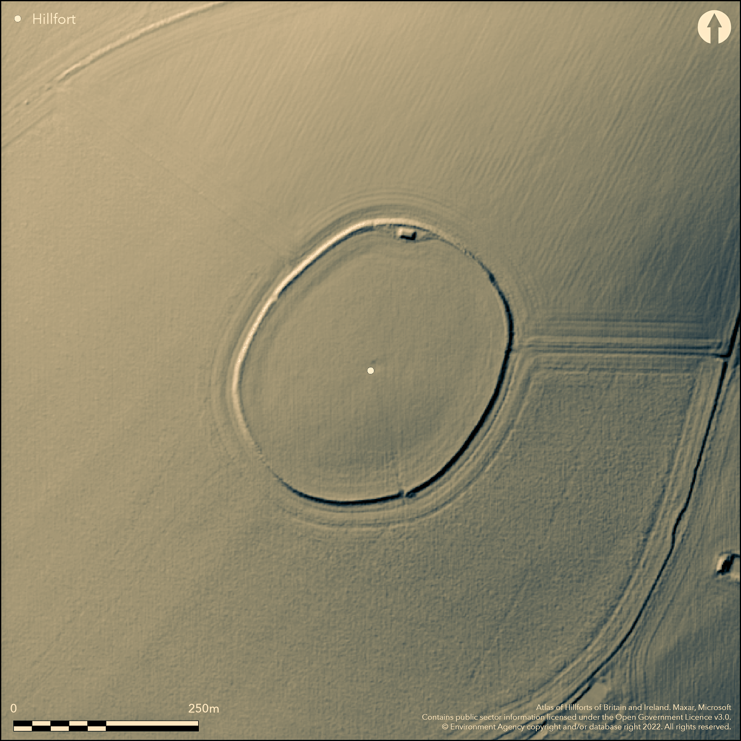
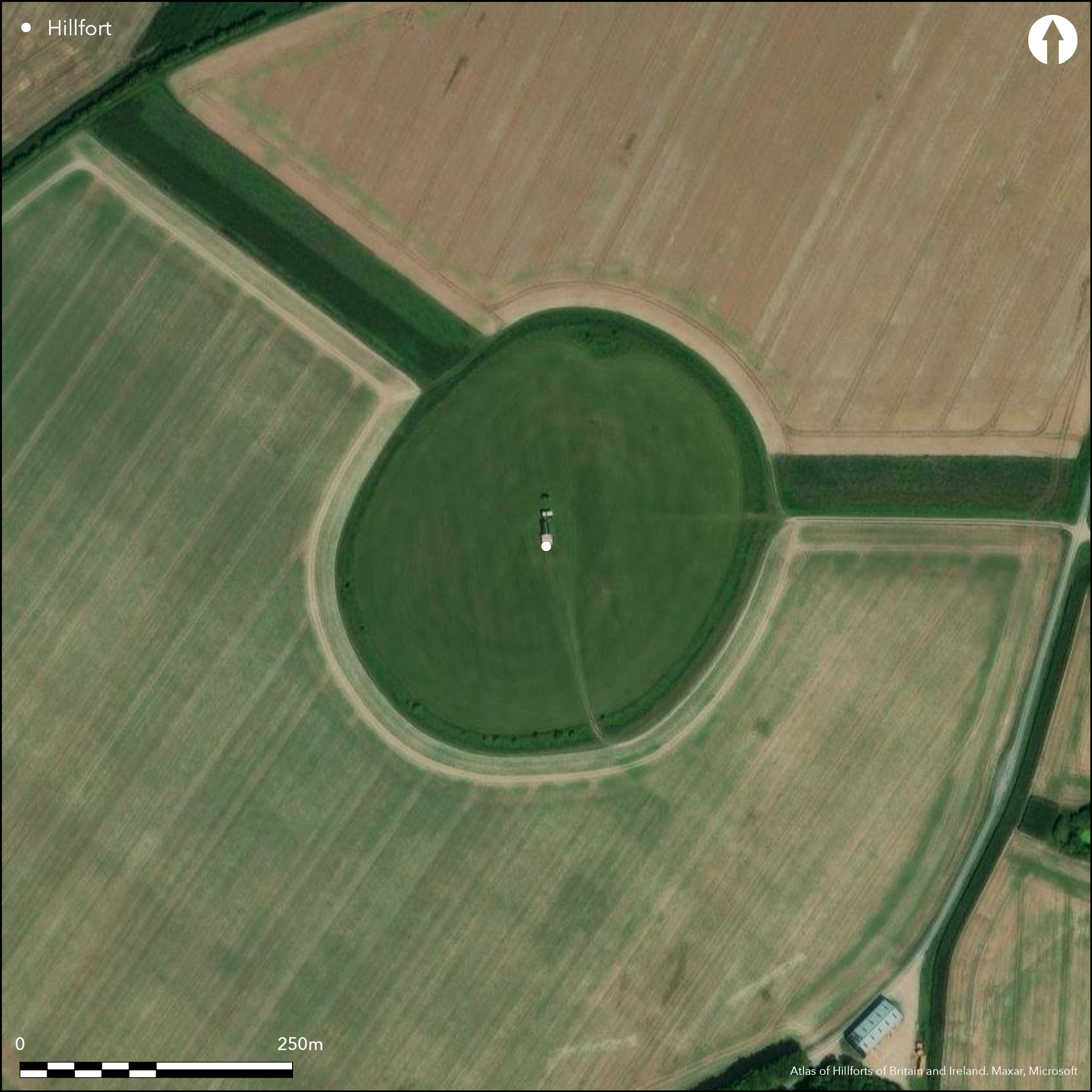
Codford Circle is classified as a 'hilltop enclosure' in the Schedule, being a slightly defended univallate enclosure possibly used for stock or storage, and dating from the late Bronze Age to early Iron Age (8th-5th centuries BC). However, it shows all the features of strategic position and commanding importance suggestive of a prominent contour hillfort. It is situated on the summit of Codford Hill, a chalk downland promontory of Salisbury Plain directly overlooking the River Wylye Valley to the S and Chitterne Brook to the SE. It is an elevated oval of 3.6ha surrounded by bank 6.5m wide and up to 1.6m high from outside. This is surrounded by a ditch 5m wide and up to 0.5m deep except for a section around SE edge where reduced by ploughing. Air photographs taken in 2001 revealed an inner ditch, probably a palisade, running concentric to the earthwork c. 25m inside, measuring 190m by 250m, and with clear opposing entrances to the E and W. Possible pit features in interior. Entrances on the SE and NW through the earthworks modern. Enclosed area ploughed. On Ist Ed. OS map (1887).
Citizen Science: ✗
Reliability of Data: Confirmed
Reliability of Interpretation: Unconfirmed
X: -225582 Y: 6650389 (EPSG: 3857)
Longitude: -2.0264408819379103 Latitude: 51.164191399854595 (EPSG:4326)
Country: England
Current County or Unitary Authority: Wiltshire
Historic County: Wiltshire
Current Parish/Community/Council/Townland: Codford
Enclosed area ploughed.
| Extant | ✓ |
| Cropmark | ✗ |
| Likely Destroyed | ✗ |
Under cultivation.
| Woodland | ✗ |
| Commercial Forestry Plantation | ✗ |
| Parkland | ✗ |
| Pasture (Grazing) | ✗ |
| Arable | ✓ |
| Scrub/Bracken | ✗ |
| Bare Outcrop | ✗ |
| Heather/Moorland | ✗ |
| Heath | ✗ |
| Built-up | ✗ |
| Coastal Grassland | ✗ |
| Other | ✗ |
Prominent hilltop enclosure/contour hillfort situated on the summit of Codford Hill, a chalk downland promontory of Salisbury Plain directly overlooking the River Wylye Valley to S and Chitterne Brook to SE.
| Contour Fort | ✓ |
| Partial Contour Fort | ✗ |
| Promontory Fort | ✗ |
| Hillslope Fort | ✗ |
| Level Terrain Fort | ✗ |
| Marsh Fort | ✗ |
| Multiple Enclosure Fort | ✗ |
| Hilltop | ✓ |
| Coastal Promontory | ✗ |
| Inland Promontory | ✗ |
| Valley Bottom | ✗ |
| Knoll/Hillock/Outcrop | ✗ |
| Ridge | ✗ |
| Cliff/Plateau-edge/Scarp | ✗ |
| Hillslope | ✗ |
| Lowland | ✗ |
| Spur | ✗ |
Dominant Topographic Feature: Hill top summit.
| North | ✗ |
| Northeast | ✗ |
| East | ✗ |
| Southeast | ✗ |
| South | ✗ |
| Southwest | ✗ |
| West | ✗ |
| Northwest | ✗ |
| Level | ✓ |
Altitude: 188.0m
N/A
Late Bronze Age to early Iron Age (8th-5th centuries BC) suggested by morphology.
Reliability: D - None
| Pre 1200BC | ✗ |
| 1200BC - 800BC | ✗ |
| 800BC - 400BC | ✓ |
| 400BC - AD50 | ✗ |
| AD50 - AD400 | ✗ |
| AD400 - AD 800 | ✗ |
| Post AD800 | ✗ |
| Unknown | ✗ |
| Pre Hillfort: | None |
| Post Hillfort: | None |
| Morphology/Earthwork/Typology: | Estimated. |
On Ist Ed. OS map (1887). 2001 J. Gardiner - small scale excavation and auger survey - results unknown. 2001-02 English Heritage Aerial Reconnaissance (south).
| 1st Identified Map Depiction (1887): | OS map. |
| Other (1984): | Visit by Hillfort Study Group |
| Excavation (2001): | J. Gardiner - small scale excavation and auger survey - results unknown. |
| Other (None): | English Heritage Aerial Reconnaissance (south). |
Air photographs taken in 2001 revealed an inner ditch, probably a palisade, running concentric to the earthwork and with clear opposing entrances to the E and W. Possible pit features in interior.
None
| None | ✓ |
| Spring | ✗ |
| Stream | ✗ |
| Pool | ✗ |
| Flush | ✗ |
| Well | ✗ |
| Other | ✗ |
None
| No Known Features | ✓ |
| Round Stone Structures | ✗ |
| Rectangular Stone Structures | ✗ |
| Curvilinear Platforms | ✗ |
| Other Roundhouse Evidence | ✗ |
| Pits | ✗ |
| Quarry Hollows | ✗ |
| Other | ✗ |
None
| No Known Excavation | ✓ |
| Pits | ✗ |
| Postholes | ✗ |
| Roundhouses | ✗ |
| Rectangular Structures | ✗ |
| Roads/Tracks | ✗ |
| Quarry Hollows | ✗ |
| Other | ✗ |
| Nothing Found | ✗ |
None
| No Known Geophysics | ✓ |
| Pits | ✗ |
| Roundhouses | ✗ |
| Rectangular Structures | ✗ |
| Roads/Tracks | ✗ |
| Quarry Hollows | ✗ |
| Other | ✗ |
| Nothing Found | ✗ |
None
| No Known Finds | ✓ |
| Pottery | ✗ |
| Metal | ✗ |
| Metalworking | ✗ |
| Human Bones | ✗ |
| Animal Bones | ✗ |
| Lithics | ✗ |
| Environmental | ✗ |
| Other | ✗ |
Air photographs taken in 2001 revealed an inner ditch, probably a palisade, running concentric to the earthwork and with clear opposing entrances to the E and W. Possible pit features in interior.
| APs Not Checked | ✗ |
| None | ✗ |
| Roundhouses | ✗ |
| Rectangular Structures | ✗ |
| Pits | ✓ |
| Postholes | ✗ |
| Roads/Tracks | ✗ |
| Other | ✓ |
SE and NW entrances possibly modern. No original entrances defined.
| 2: | SE and NW entrances possibly modern. |
| 2: | No original entrances defined. |
Guard Chambers: ✗
Chevaux de Frise: ✗
Surrounded by bank 6.5m wide and up to 1.6m high from outside with ditch 5m wide and up to 0.5m deep except for section around SE edge where reduced by ploughing. Air photographs taken in 2001 revealed an inner ditch, probably a palisade, running concentric to the earthwork c. 25m inside, measuring 190m by 250m, and with clear opposing entrances to the E and W.
| Area 1: | 3.6ha. |
| Total: | 3.6ha. |
Total Footprint Area: Noneha.
None
| ✗ | None |
| ✓ | None |
| NE Quadrant: | 1 |
| SE Quadrant: | 1 |
| SW Quadrant: | 1 |
| NW Quadrant: | 1 |
| Total: | 1 |
| Partial Univallate | ✗ |
| Univallate | ✓ |
| Partial Bivallate | ✗ |
| Bivallate | ✗ |
| Partial Multivallate | ✗ |
| Multivallate | ✗ |
| Unknown | ✗ |
| Partial Univallate | ✗ |
| Univallate | ✗ |
| Partial Bivallate | ✗ |
| Bivallate | ✗ |
| Partial Multivallate | ✗ |
| Multivallate | ✗ |
Air photographs taken in 2001 revealed an inner ditch, probably a palisade, running concentric to the earthwork c. 25m inside, measuring 190m by 250m, and with clear opposing entrances to the E and W.
| None | ✗ |
| Earthen Bank | ✓ |
| Stone Wall | ✗ |
| Rubble | ✗ |
| Wall-walk | ✗ |
| Evidence of Timber | ✗ |
| Vitrification | ✗ |
| Other Burning | ✗ |
| Palisade | ✓ |
| Counter Scarp Bank | ✗ |
| Berm | ✗ |
| Unfinished | ✗ |
| Other | ✗ |
None
| None | ✗ |
| Earthen Bank | ✗ |
| Stone Wall | ✗ |
| Murus Duplex | ✗ |
| Timber-framed | ✗ |
| Timber-laced | ✗ |
| Vitrification | ✗ |
| Other Burning | ✗ |
| Palisade | ✗ |
| Counter Scarp Bank | ✗ |
| Berm | ✗ |
| Unfinished | ✗ |
| No Known Excavation | ✓ |
| Other | ✗ |
| ✗ | None |
| ✓ | Inner ditch in interior, probably a palisade, running concentric to the earthwork which has bank and ditch. |
Number of Ditches: 2
| ✗ | None |
Colt Hoare 1812. The ancient history of Wiltshire, I, London: Miller, 80.
Pugh, R.B. and Crittall, E. 1957. A history of Wiltshire, 1.1, The Victoria history of the counties of England, 264.
Atlas of Hillforts:
Wikidata:
This work is licensed under CC BY-SA 4.0![]()
![]()
![]() and should be cited as:
and should be cited as:
Lock, Gary and Ralston, Ian. 2024. Atlas of Hillforts of Britain and Ireland. Available at: https://hillforts.arch.ox.ac.uk
Document Version 1.1