LiDAR 1m DTM Hillshade
Satellite Imagery
LiDAR 1m DTM Hillshade
Satellite Imagery
Scroll left/right to view further images.
HER: Somerset 33351 (None)
NMR: ST 03 SE 1 (188401)
SM: 1020724
NGR: ST07053378
X: 307050 Y: 133780 (OSGB36)
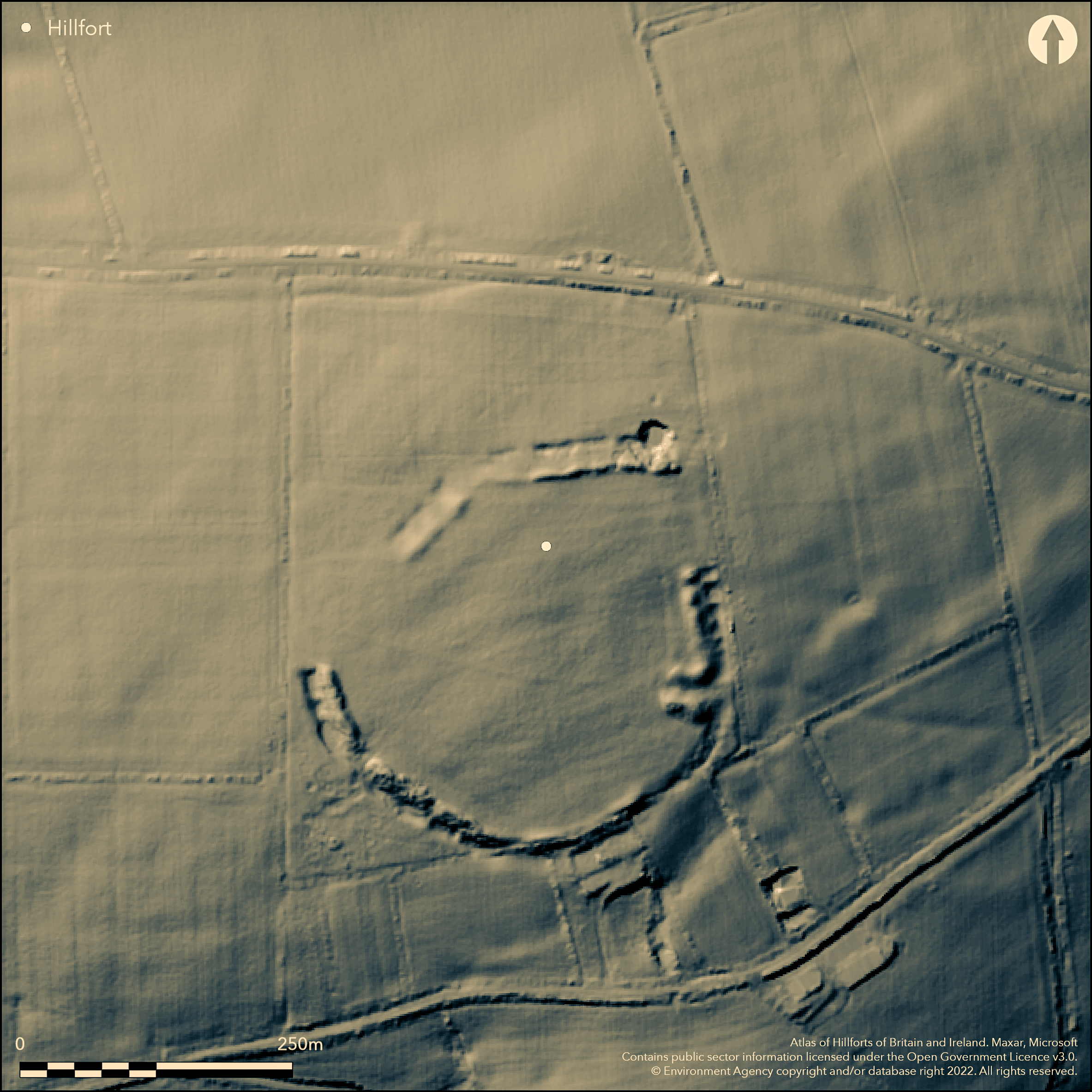
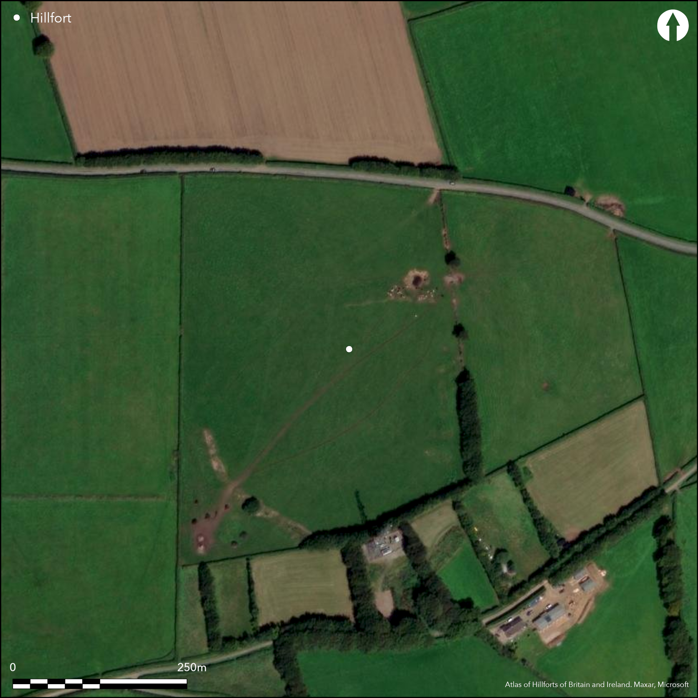
Fragmentary remains of partial contour circular bank and ditch site located on a prominent hill above Doniford Stream to the E and sea to the N. On 1st Ed OS map (1885-1900). A weak bank and shallow ditch on the E side, but S mutilated by field bank, with the W almost complete with evidence of sectional gang working. Bank is also highest on the W rising to 3m where the broad ditch and bank are c. 10m across. a deep pool lies in the ditch to the NE and could indicate a past water source, but nothing proved. The causewayed effect on the N side, with a wide berm between quarry hollows, is probably due to incomplete construction rather than suggested earlier Neolithic enclosure. An inturned entrance well developed on the E and a gap on the SW could also be original. No excavations.
Citizen Science: ✗
Reliability of Data: Confirmed
Reliability of Interpretation: Confirmed
X: -370559 Y: 6638242 (EPSG: 3857)
Longitude: -3.3287908762370293 Latitude: 51.09571220211035 (EPSG:4326)
Country: England
Current County or Unitary Authority: Somerset
Historic County: Somerset
Current Parish/Community/Council/Townland: Brompton Ralf
Fragmentary remains only of bank and ditch. No deliberate destruction of ramparts nor ditch infilling reported, but animal damage to main rampart on S, especially near field boundary.
| Extant | ✓ |
| Cropmark | ✗ |
| Likely Destroyed | ✗ |
Upland pasture with occasional ploughing.
| Woodland | ✗ |
| Commercial Forestry Plantation | ✗ |
| Parkland | ✗ |
| Pasture (Grazing) | ✓ |
| Arable | ✓ |
| Scrub/Bracken | ✗ |
| Bare Outcrop | ✗ |
| Heather/Moorland | ✗ |
| Heath | ✗ |
| Built-up | ✗ |
| Coastal Grassland | ✗ |
| Other | ✗ |
Partial contour circular bank and ditch site located on a prominent hill above Doniford Stream to the E and sea to the N.
| Contour Fort | ✗ |
| Partial Contour Fort | ✓ |
| Promontory Fort | ✗ |
| Hillslope Fort | ✗ |
| Level Terrain Fort | ✗ |
| Marsh Fort | ✗ |
| Multiple Enclosure Fort | ✗ |
| Hilltop | ✓ |
| Coastal Promontory | ✗ |
| Inland Promontory | ✗ |
| Valley Bottom | ✗ |
| Knoll/Hillock/Outcrop | ✗ |
| Ridge | ✗ |
| Cliff/Plateau-edge/Scarp | ✗ |
| Hillslope | ✓ |
| Lowland | ✗ |
| Spur | ✗ |
Dominant Topographic Feature: Prominent hill above Doniford Stream to the E.
| North | ✗ |
| Northeast | ✗ |
| East | ✗ |
| Southeast | ✗ |
| South | ✓ |
| Southwest | ✗ |
| West | ✗ |
| Northwest | ✗ |
| Level | ✗ |
Altitude: 392.0m
N/A
None
Reliability: D - None
| Pre 1200BC | ✗ |
| 1200BC - 800BC | ✗ |
| 800BC - 400BC | ✗ |
| 400BC - AD50 | ✗ |
| AD50 - AD400 | ✗ |
| AD400 - AD 800 | ✗ |
| Post AD800 | ✗ |
| Unknown | ✓ |
| Pre Hillfort: | The causewayed effect on the N side, with a wide berm between quarry hollows, is probably due to incomplete construction rather than suggested earlier Neolithic enclosure. |
| Post Hillfort: | None |
On 1st Ed OS map (1885-1900). Oxford Archaeology Unit investigation 1996. AP investigation Exmoor National Park National Mapping Programme - English Heritage 2007-2009.
| Other (1989): | Visited by Hillfort Study Group |
| Other (1996): | Oxford Archaeology Unit investigation 1996. |
| 1st Identified Map Depiction (None): | 1st Ed OS map |
| Other (None): | AP investigation Exmoor National Park National Mapping Programme - English Heritage. |
Wartime cultivation unearthed worked flakes, cores and three leaf-shaped arrowheads. AP investigation Exmoor National Park National Mapping Programme - English Heritage. Deep pool in ditch to NE could possibly indicate a past water source.
Deep pool in ditch to NE could possibly indicate a past water source.
| None | ✗ |
| Spring | ✗ |
| Stream | ✗ |
| Pool | ✓ |
| Flush | ✗ |
| Well | ✗ |
| Other | ✗ |
None
| No Known Features | ✗ |
| Round Stone Structures | ✗ |
| Rectangular Stone Structures | ✗ |
| Curvilinear Platforms | ✗ |
| Other Roundhouse Evidence | ✗ |
| Pits | ✗ |
| Quarry Hollows | ✓ |
| Other | ✗ |
None
| No Known Excavation | ✓ |
| Pits | ✗ |
| Postholes | ✗ |
| Roundhouses | ✗ |
| Rectangular Structures | ✗ |
| Roads/Tracks | ✗ |
| Quarry Hollows | ✗ |
| Other | ✗ |
| Nothing Found | ✗ |
None
| No Known Geophysics | ✓ |
| Pits | ✗ |
| Roundhouses | ✗ |
| Rectangular Structures | ✗ |
| Roads/Tracks | ✗ |
| Quarry Hollows | ✗ |
| Other | ✗ |
| Nothing Found | ✗ |
Wartime cultivation unearthed worked flakes, cores and three leaf-shaped arrowheads.
| No Known Finds | ✗ |
| Pottery | ✗ |
| Metal | ✗ |
| Metalworking | ✗ |
| Human Bones | ✗ |
| Animal Bones | ✗ |
| Lithics | ✓ |
| Environmental | ✗ |
| Other | ✗ |
AP investigation Exmoor National Park National Mapping Programme - English Heritage.
| APs Not Checked | ✓ |
| None | ✗ |
| Roundhouses | ✗ |
| Rectangular Structures | ✗ |
| Pits | ✗ |
| Postholes | ✗ |
| Roads/Tracks | ✗ |
| Other | ✗ |
Two entrances, that inturned to E definitely original, the simple gap to SW possibly.
| 2: | None |
| 2: | None |
Guard Chambers: ✗
Chevaux de Frise: ✗
| 1. In-turned (East): | None |
| 2. Simple Gap (South west): | Possible original entrance |
A weak bank and shallow ditch on the E side, but S mutilated by field bank with the W almost complete with evidence of sectional gang working. Bank is also highest on the W rising to 3m where the broad ditch and bank are c 10m across. The causewayed effect on the N side, with a wide berm between quarry hollows, is probably due to incomplete construction rather than suggested earlier Neolithic enclosure.
| Area 1: | 3.6ha. |
| Total: | 3.6ha. |
Total Footprint Area: Noneha.
None
| ✗ | None |
| ✓ | None |
| NE Quadrant: | 1 |
| SE Quadrant: | 1 |
| SW Quadrant: | 1 |
| NW Quadrant: | 1 |
| Total: | 1 |
| Partial Univallate | ✗ |
| Univallate | ✓ |
| Partial Bivallate | ✗ |
| Bivallate | ✗ |
| Partial Multivallate | ✗ |
| Multivallate | ✗ |
| Unknown | ✗ |
| Partial Univallate | ✗ |
| Univallate | ✗ |
| Partial Bivallate | ✗ |
| Bivallate | ✗ |
| Partial Multivallate | ✗ |
| Multivallate | ✗ |
Causewayed effect on the N side, with wide berm between quarry hollows, probably due to incomplete construction rather than suggested earlier Neolithic enclosure.
| None | ✗ |
| Earthen Bank | ✓ |
| Stone Wall | ✗ |
| Rubble | ✗ |
| Wall-walk | ✗ |
| Evidence of Timber | ✗ |
| Vitrification | ✗ |
| Other Burning | ✗ |
| Palisade | ✗ |
| Counter Scarp Bank | ✗ |
| Berm | ✓ |
| Unfinished | ✓ |
| Other | ✗ |
None
| None | ✗ |
| Earthen Bank | ✗ |
| Stone Wall | ✗ |
| Murus Duplex | ✗ |
| Timber-framed | ✗ |
| Timber-laced | ✗ |
| Vitrification | ✗ |
| Other Burning | ✗ |
| Palisade | ✗ |
| Counter Scarp Bank | ✗ |
| Berm | ✗ |
| Unfinished | ✗ |
| No Known Excavation | ✓ |
| Other | ✗ |
| ✓ | Possible evidence of working sections on the W. |
| ✓ | Ditch intermittent. |
Number of Ditches: 1
| ✗ | None |
Burrow, E.J. 1924. Ancient earthworks and camps of Somerset, Cheltenham: E.J. Burrow, 106-107.
Page, W. (ed) 1911. The Victoria County History of the County of Somerset, 2, 508, London: St Catherine Press.
Smith, K.1998. - Note 1998: Somerset archaeology and natural history. Proc Somerset Archaeol and Natur Hist Soc, 141, 176.
Atlas of Hillforts:
Wikidata:
This work is licensed under CC BY-SA 4.0![]()
![]()
![]() and should be cited as:
and should be cited as:
Lock, Gary and Ralston, Ian. 2024. Atlas of Hillforts of Britain and Ireland. Available at: https://hillforts.arch.ox.ac.uk
Document Version 1.1