
LiDAR 1m DTM Hillshade
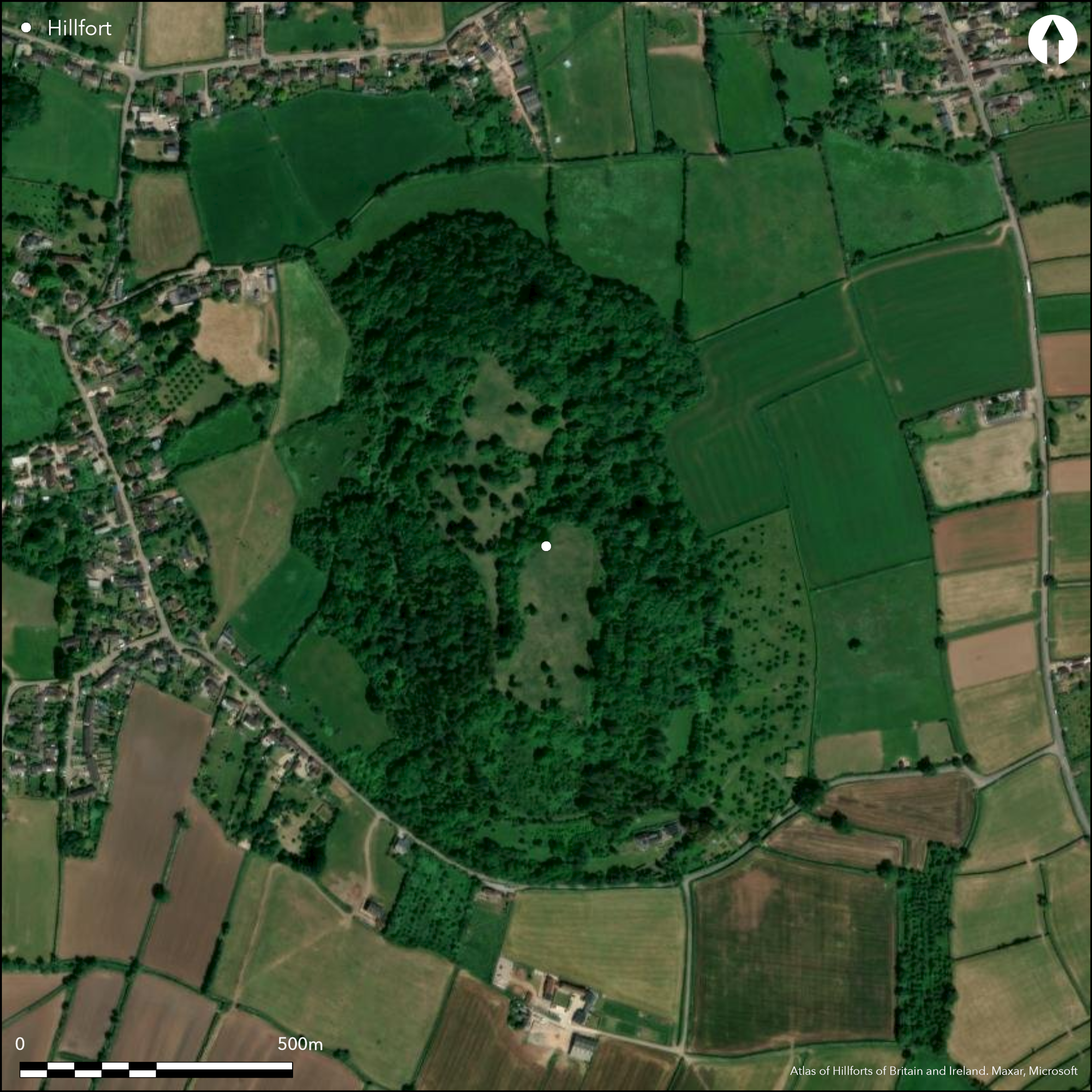
Satellite Imagery
LiDAR 1m DTM Hillshade
Satellite Imagery
Scroll left/right to view further images.
HER: Somerset 53760 (None)
NMR: ST 43 SE 15 (194013)
SM: 1014715
NGR: ST485322
X: 348500 Y: 132200 (OSGB36)
Large univallate contour hillfort located on Dundon Hill above a sharp bend of the River Cary and overlooking the SE Somerset Levels. Steep slopes surround the site and the site rises to the N and S, flat in centre. Although much altered by limestone quarrying, which ended in 1925, a bank of stones extends along the edge of the hill following the contour, the outer face being steeply scarped. The rampart has been destroyed in places; on the NW only a scarp remains, and some 46m of the E side has gone. On the E side, c. 4.8m below the top of the bank, is a terrace or ledge, the ground falling steeply away. Surviving ramparts rise to 2m in height, but average 0.4-1m. Although there are gaps to the W and SE corner, now used as present access into interior, the likely original entrance was to the E and now destroyed. An irregular trench cuts across the interior marks the past quarrying operations, and this extended through, and destroyed, part of the NE ramparts. At the SE corner is the Dundon Beacon mound, a former Bronze Age barrow later re-worked with the hillfort defences as a possible Norman motte and bailey castle site. Medieval lynchets run around the N, E and W sides of the hill, those along the E side at the rampart base being the best preserved. Excavation of the mound in 1827 found an undated burial with tin rings and Bronze Age pottery fragments. Animal bone and sherds of late Iron Age pottery from water pipe trench passing through NW rampart (Hollinrake 1997). On 1st Ed OS map (1885-1900).
Citizen Science: ✗
Reliability of Data: Confirmed
Reliability of Interpretation: Confirmed
X: -304648 Y: 6636650 (EPSG: 3857)
Longitude: -2.736702218354108 Latitude: 51.08673430117806 (EPSG:4326)
Country: England
Current County or Unitary Authority: Somerset
Historic County: Somerset
Current Parish/Community/Council/Townland: Compton Dundon
Ramparts complete circuit, but incomplete in places. In SE corner is Dundon Beacon mound, a former Bronze Age barrow later used as a Norman motte.
| Extant | ✓ |
| Cropmark | ✗ |
| Likely Destroyed | ✗ |
Site surrounded by steep wooded slopes of Hillwall Wood; less so on S and part of NW quadrant. Interior grazed scrubby grassland. Dundon Beacon mound, a former Bronze Age barrow later used as a Norman motte. Nature reserve.
| Woodland | ✓ |
| Commercial Forestry Plantation | ✗ |
| Parkland | ✗ |
| Pasture (Grazing) | ✓ |
| Arable | ✗ |
| Scrub/Bracken | ✓ |
| Bare Outcrop | ✗ |
| Heather/Moorland | ✗ |
| Heath | ✗ |
| Built-up | ✗ |
| Coastal Grassland | ✗ |
| Other | ✓ |
Large univallate contour hillfort located on Dundon Hill above a sharp bend of the River Cary and overlooking the Somerset Levels. Steep slopes surround the site.
| Contour Fort | ✓ |
| Partial Contour Fort | ✗ |
| Promontory Fort | ✗ |
| Hillslope Fort | ✗ |
| Level Terrain Fort | ✗ |
| Marsh Fort | ✗ |
| Multiple Enclosure Fort | ✗ |
| Hilltop | ✓ |
| Coastal Promontory | ✗ |
| Inland Promontory | ✗ |
| Valley Bottom | ✗ |
| Knoll/Hillock/Outcrop | ✗ |
| Ridge | ✗ |
| Cliff/Plateau-edge/Scarp | ✗ |
| Hillslope | ✗ |
| Lowland | ✗ |
| Spur | ✗ |
Dominant Topographic Feature: Steep Dundon Hill.
| North | ✗ |
| Northeast | ✗ |
| East | ✗ |
| Southeast | ✗ |
| South | ✗ |
| Southwest | ✗ |
| West | ✗ |
| Northwest | ✗ |
| Level | ✓ |
Altitude: 103.0m
N/A
Site Iron Age and sherds of late Iron Age pottery from water pipe trench passing through NW rampart. In SE corner is Dundon Beacon mound, a former Bronze Age barrow later re-worked with the hillfort defences as a Norman motte and bailey castle site. Lynchets indicate medieval use. Later limestone quarrying.
Reliability: B - Medium
| Pre 1200BC | ✗ |
| 1200BC - 800BC | ✗ |
| 800BC - 400BC | ✗ |
| 400BC - AD50 | ✓ |
| AD50 - AD400 | ✗ |
| AD400 - AD 800 | ✗ |
| Post AD800 | ✗ |
| Unknown | ✗ |
| Pre Hillfort: | None |
| Post Hillfort: | None |
| Artefactual: | Sherds of late Iron Age pottery from water pipe trench passing through NW rampart. |
| Morphology/Earthwork/Typology: | In SE corner is Dundon Beacon mound, a former Bronze Age barrow later used as a Norman motte and bailey castle site. |
On 1st Ed OS map (1885-1900). RCHME survey 1994, ref. no. 890206. Investigation for water pipe trench 1997 showed stratigraphic sequence of rampart and possible pre-rampart level of worn cobbles.
| Earthwork Survey (1994): | RCHME survey 1994. |
| Other (1997): | Water pipe investigation by C. and N. Hollinrake. |
| 1st Identified Map Depiction (None): | 1st Ed OS |
No known true excavation of hillfort, apart from water pipe trench 1997 passing through NW rampart. Dundon Beacon mound 'excavated' 1827.Tin rings and Bronze Age pottery fragments from Dundon Beacon mound and animal bone and sherds of late Iron Age pottery from water pipe trench. Spring located in interior regards as a holy well in the medieval period.
Spring located in interior regards as a holy well in the medieval period.
| None | ✗ |
| Spring | ✓ |
| Stream | ✗ |
| Pool | ✗ |
| Flush | ✗ |
| Well | ✗ |
| Other | ✗ |
None
| No Known Features | ✓ |
| Round Stone Structures | ✗ |
| Rectangular Stone Structures | ✗ |
| Curvilinear Platforms | ✗ |
| Other Roundhouse Evidence | ✗ |
| Pits | ✗ |
| Quarry Hollows | ✗ |
| Other | ✗ |
No known true excavation of hillfort, apart from water pipe trench 1997. Dundon Beacon mound 'excavated' 1827.
| No Known Excavation | ✓ |
| Pits | ✗ |
| Postholes | ✗ |
| Roundhouses | ✗ |
| Rectangular Structures | ✗ |
| Roads/Tracks | ✗ |
| Quarry Hollows | ✗ |
| Other | ✗ |
| Nothing Found | ✗ |
None
| No Known Geophysics | ✓ |
| Pits | ✗ |
| Roundhouses | ✗ |
| Rectangular Structures | ✗ |
| Roads/Tracks | ✗ |
| Quarry Hollows | ✗ |
| Other | ✗ |
| Nothing Found | ✗ |
Tin rings and Bronze Age pottery fragments from Dundon Beacon mound. Animal bone and sherds of late Iron Age pottery from water pipe trench passing through NW rampart.
| No Known Finds | ✗ |
| Pottery | ✓ |
| Metal | ✓ |
| Metalworking | ✗ |
| Human Bones | ✗ |
| Animal Bones | ✓ |
| Lithics | ✗ |
| Environmental | ✗ |
| Other | ✗ |
None
| APs Not Checked | ✓ |
| None | ✗ |
| Roundhouses | ✗ |
| Rectangular Structures | ✗ |
| Pits | ✗ |
| Postholes | ✗ |
| Roads/Tracks | ✗ |
| Other | ✗ |
Original entrance possibly on E side where now destroyed. Two modern gaps to the W and SE corner.
| 3: | Two modern gaps to the W and SE corner. |
| 2: | Original entrance possibly on E side where now destroyed. |
Guard Chambers: ✗
Chevaux de Frise: ✗
| 1. Simple Gap (East): | Type not defined. Simple gap default. |
Although much altered by limestone quarrying, which ended in 1925, a bank of stones extends along the edge of the hill following the contour, the outer face being steeply scarped. The rampart has been destroyed in places; on the NW only a scarp remains, and some 46m of the E side has gone. On the E side, c. 4.8m below the top of the bank, is a terrace or ledge, the ground falling steeply away. Surviving ramparts rise to 2m in height, but average 0.4-1m.
| Area 1: | 5.5ha. |
| Total: | 5.5ha. |
Total Footprint Area: Noneha.
None
| ✗ | None |
| ✗ | None |
| NE Quadrant: | 1 |
| SE Quadrant: | 1 |
| SW Quadrant: | 1 |
| NW Quadrant: | 0 |
| Total: | 1 |
| Partial Univallate | ✓ |
| Univallate | ✗ |
| Partial Bivallate | ✗ |
| Bivallate | ✗ |
| Partial Multivallate | ✗ |
| Multivallate | ✗ |
| Unknown | ✗ |
| Partial Univallate | ✗ |
| Univallate | ✗ |
| Partial Bivallate | ✗ |
| Bivallate | ✗ |
| Partial Multivallate | ✗ |
| Multivallate | ✗ |
On the E side, c. 4.8m below the top of the bank, is a terrace or ledge, the ground falling steeply away. Banks of stone evident; possibly stone walled site.
| None | ✗ |
| Earthen Bank | ✗ |
| Stone Wall | ✓ |
| Rubble | ✓ |
| Wall-walk | ✗ |
| Evidence of Timber | ✗ |
| Vitrification | ✗ |
| Other Burning | ✗ |
| Palisade | ✗ |
| Counter Scarp Bank | ✗ |
| Berm | ✗ |
| Unfinished | ✗ |
| Other | ✗ |
Investigation for water pipe trench through NW rampart 1997 exposed earliest dumped stone deposit at base of bank and showed stratigraphic sequence of rampart. Burnt timbers, possibly framework supporting stone rampart recorded. Third clay deposit overlying rubble possible later phase of defences. Possible pre-rampart level of worn cobbles below rear of rampart.
| None | ✗ |
| Earthen Bank | ✓ |
| Stone Wall | ✓ |
| Murus Duplex | ✗ |
| Timber-framed | ✓ |
| Timber-laced | ✗ |
| Vitrification | ✗ |
| Other Burning | ✓ |
| Palisade | ✗ |
| Counter Scarp Bank | ✗ |
| Berm | ✗ |
| Unfinished | ✗ |
| No Known Excavation | ✗ |
| Other | ✗ |
| ✗ | None |
| ✗ | No ditches are recorded but probably buried features. |
Number of Ditches: 0
| ✗ | None |
Bothamley, C.H. 1911. Compton Dundon Hillfort. A history of the County of Somerset (VCH), 2, 490-91.
Burrow, I. 1981. Hillfort and hill-top settlement in Somerset in the first to eighth centuries AD, BAR British Series 1(1974) - 91, 214.
Grinsell, L.V. 1969. The Somerset Barrows Part 1, Proc Somerset Archaeol and Natur Hist Soc, 113, 18, 28.
Hollinrake, C and Hollinrake, N.1997. An archaeological excavation of a water pipe trench on Dundon Hillfort, Compton Dundon, Somerset: interim report.
Newman, P. 1995. Compton Dundon, Dundon Hill and Beacon, ST485030330, in eds, C.J. Webster and R.A. Croft, Somerset Archaeology 1994, Proc Somerset Archaeol and Natur Hist Soc, 138, 172.
RCHME 1994. Dundon Hill Camp, Somerset, RCHME descriptive survey.
Atlas of Hillforts:
Wikidata:
This work is licensed under CC BY-SA 4.0![]()
![]()
![]() and should be cited as:
and should be cited as:
Lock, Gary and Ralston, Ian. 2024. Atlas of Hillforts of Britain and Ireland. Available at: https://hillforts.arch.ox.ac.uk
Document Version 1.1