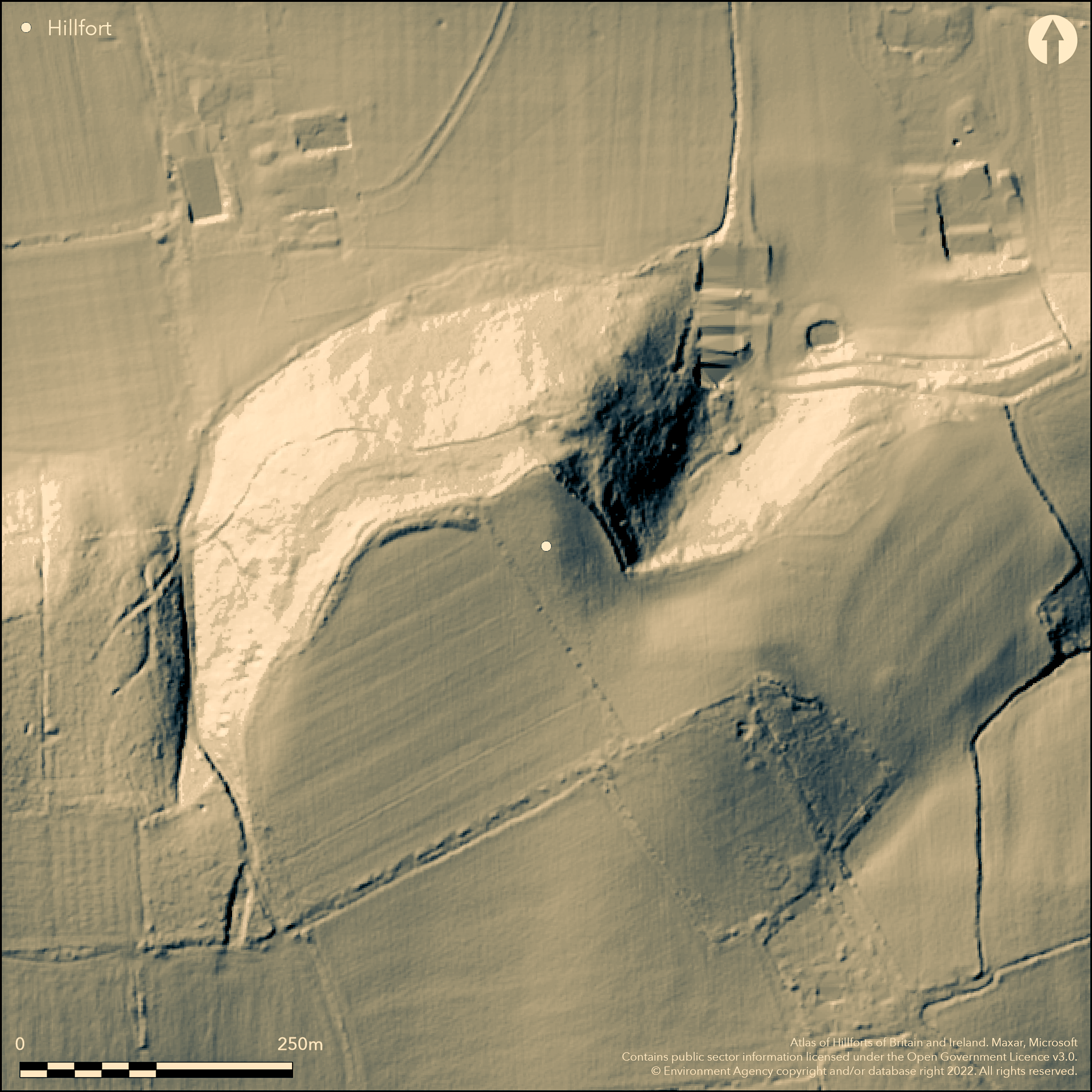
LiDAR 1m DTM Hillshade

Satellite Imagery
LiDAR 1m DTM Hillshade
Satellite Imagery
Scroll left/right to view further images.
HER: Somerset 54484 (None)
NMR: ST 42 NE 28 (193579)
SM: None
NGR: ST46062963
X: 346060 Y: 129630 (OSGB36)
Cropmark promontory fort located on a prominent spur bounded by steep sloping hillsides at the extreme edge of limestone uplands overlooking the River Cary and SE Somerset Levels, King's Sedgemoor. Confirmed by aerial survey 1990 and geophysics 1993. Investigation has a confused history beginning with excavation of a mound - an alleged Bronze Age barrow - in the interior of the fort. A skeleton with an iron bracelet on the right arm, an iron knife, bone pin, two fibulae and a large quantity of Romano-British pottery were found. A Roman farmstead site was later suggested. A geophysical survey of 1993, however, confirmed promontory fort defences, indicated by aerial survey in 1990. On the S and E three lines of defence noted. A possible entrance on the E disturbed by the barrow excavations. Interior divided into two areas, the smaller devoted to most of the roundhouses identified, but both contained pits. Three linear features ran from the SW towards a possible W entrance. Banks to N on edge of West Wood and ditch to E noted, plus slight irregular scarp identified as remnant of mound suggested as a barrow. This, together with its position in the middle of the fort's defences, plus the rather confused account of the excavation, suggest that the alleged barrow mound may be part of a denuded rampart. The burial and Romano-British pottery may belong to a later phase of occupation on the hill-top.
Citizen Science: ✗
Reliability of Data: Confirmed
Reliability of Interpretation: Confirmed
X: -308483 Y: 6632516 (EPSG: 3857)
Longitude: -2.77115250260057 Latitude: 51.063401472871725 (EPSG:4326)
Country: England
Current County or Unitary Authority: Somerset
Historic County: Somerset
Current Parish/Community/Council/Townland: Somerton
Ploughed-out.
| Extant | ✗ |
| Cropmark | ✓ |
| Likely Destroyed | ✓ |
Ditch in West Wood to E.
| Woodland | ✓ |
| Commercial Forestry Plantation | ✗ |
| Parkland | ✗ |
| Pasture (Grazing) | ✗ |
| Arable | ✓ |
| Scrub/Bracken | ✗ |
| Bare Outcrop | ✗ |
| Heather/Moorland | ✗ |
| Heath | ✗ |
| Built-up | ✗ |
| Coastal Grassland | ✗ |
| Other | ✗ |
Cropmark promontory fort located on a prominent spur bounded by steep sloping hillsides at the extreme edge of limestone uplands, overlooking the River Cary and SE Somerset Levels, King's Sedgemoor.
| Contour Fort | ✗ |
| Partial Contour Fort | ✗ |
| Promontory Fort | ✓ |
| Hillslope Fort | ✗ |
| Level Terrain Fort | ✗ |
| Marsh Fort | ✗ |
| Multiple Enclosure Fort | ✗ |
| Hilltop | ✗ |
| Coastal Promontory | ✗ |
| Inland Promontory | ✓ |
| Valley Bottom | ✗ |
| Knoll/Hillock/Outcrop | ✗ |
| Ridge | ✗ |
| Cliff/Plateau-edge/Scarp | ✗ |
| Hillslope | ✗ |
| Lowland | ✗ |
| Spur | ✓ |
Dominant Topographic Feature: Prominent spur
| North | ✗ |
| Northeast | ✗ |
| East | ✗ |
| Southeast | ✗ |
| South | ✗ |
| Southwest | ✗ |
| West | ✗ |
| Northwest | ✗ |
| Level | ✓ |
Altitude: 72.0m
N/A
Although excavated, geophysics suggests that the Bronze Age 'barrow' was in fact a part of promontory fort defences. Finds of Romano-British date suggest later phase occupation.
Reliability: B - Medium
| Pre 1200BC | ✗ |
| 1200BC - 800BC | ✗ |
| 800BC - 400BC | ✗ |
| 400BC - AD50 | ✓ |
| AD50 - AD400 | ✗ |
| AD400 - AD 800 | ✗ |
| Post AD800 | ✗ |
| Unknown | ✗ |
| Pre Hillfort: | None |
| Post Hillfort: | None |
| Artefactual: | Finds of Romano-British date suggest later occupation. |
Aerial survey investigation 1990. Geophysical survey 1993 which showed that the supposed Bronze Age barrow on site possibly part of promontory fort defences. Excavation of Westwood Barrow 1945-6.
| Other (1990): | Aerial survey investigation - no details. |
| Geophysical Survey (1993): | Geophysical Surveys of Bradford. |
| Excavation (None): | Excavation of Westwood Barrow 1945-6 by R.E. Thyer. |
Aerial photograph investigation 1990 proved promontory fort. A skeleton with an iron bracelet on the right arm, an iron knife, bone pin, two fibulae and a large quantity of Romano-British pottery were found. Magnetometer and resistivity surveys 1993 noted defences and interior features - roundhouses, pits, and linear features outside fort.
None
| None | ✓ |
| Spring | ✗ |
| Stream | ✗ |
| Pool | ✗ |
| Flush | ✗ |
| Well | ✗ |
| Other | ✗ |
None
| No Known Features | ✓ |
| Round Stone Structures | ✗ |
| Rectangular Stone Structures | ✗ |
| Curvilinear Platforms | ✗ |
| Other Roundhouse Evidence | ✗ |
| Pits | ✗ |
| Quarry Hollows | ✗ |
| Other | ✗ |
None
| No Known Excavation | ✓ |
| Pits | ✗ |
| Postholes | ✗ |
| Roundhouses | ✗ |
| Rectangular Structures | ✗ |
| Roads/Tracks | ✗ |
| Quarry Hollows | ✗ |
| Other | ✗ |
| Nothing Found | ✗ |
Magnetometer and resistivity surveys 1993 noted defences and interior features - roundhouses, pits, and linear features outside fort.
| No Known Geophysics | ✗ |
| Pits | ✓ |
| Roundhouses | ✓ |
| Rectangular Structures | ✗ |
| Roads/Tracks | ✗ |
| Quarry Hollows | ✗ |
| Other | ✓ |
| Nothing Found | ✗ |
A skeleton with an iron bracelet on the right arm, an iron knife, bone pin, two fibulae and a large quantity of Romano-British pottery were found.
| No Known Finds | ✗ |
| Pottery | ✓ |
| Metal | ✓ |
| Metalworking | ✗ |
| Human Bones | ✓ |
| Animal Bones | ✗ |
| Lithics | ✗ |
| Environmental | ✗ |
| Other | ✓ |
Aerial photograph investigation 1990 proved promontory fort defences.
| APs Not Checked | ✗ |
| None | ✗ |
| Roundhouses | ✗ |
| Rectangular Structures | ✗ |
| Pits | ✗ |
| Postholes | ✗ |
| Roads/Tracks | ✗ |
| Other | ✓ |
Possible entrance on the E disturbed by the barrow excavations.
| None: | Breaks not determined. |
| 2: | None |
Guard Chambers: ✗
Chevaux de Frise: ✗
| 1. Simple Gap (East): | Possible entrance on the E disturbed by the barrow excavations. Type not defined. Simple gap default. |
On the S and E three lines of defence noted. A possible entrance on the E disturbed by the barrow excavations. Interior divided into two areas, the smaller devoted to most of the roundhouses identified, but both contained pits. Three linear features ran from the SW towards a possible W entrance. Banks to N at edge of West Wood and ditch to E noted, plus slight irregular scarp identified as remnant of mound suggested as a barrow. This, together with its position in the middle of the fort's defences, plus the rather confused account of the excavation, suggest that the alleged barrow mound may be part of a denuded rampart.
| Area 1: | Noneha. |
| Total: | Noneha. |
Total Footprint Area: Noneha.
None
| ✗ | Area not defined. |
| ✗ | None |
| NE Quadrant: | 0 |
| SE Quadrant: | 1 |
| SW Quadrant: | None |
| NW Quadrant: | 0 |
| Total: | 1 |
| Partial Univallate | ✓ |
| Univallate | ✗ |
| Partial Bivallate | ✗ |
| Bivallate | ✗ |
| Partial Multivallate | ✗ |
| Multivallate | ✗ |
| Unknown | ✗ |
| Partial Univallate | ✗ |
| Univallate | ✗ |
| Partial Bivallate | ✗ |
| Bivallate | ✗ |
| Partial Multivallate | ✗ |
| Multivallate | ✗ |
None
| None | ✓ |
| Earthen Bank | ✗ |
| Stone Wall | ✗ |
| Rubble | ✗ |
| Wall-walk | ✗ |
| Evidence of Timber | ✗ |
| Vitrification | ✗ |
| Other Burning | ✗ |
| Palisade | ✗ |
| Counter Scarp Bank | ✗ |
| Berm | ✗ |
| Unfinished | ✗ |
| Other | ✗ |
None
| None | ✓ |
| Earthen Bank | ✗ |
| Stone Wall | ✗ |
| Murus Duplex | ✗ |
| Timber-framed | ✗ |
| Timber-laced | ✗ |
| Vitrification | ✗ |
| Other Burning | ✗ |
| Palisade | ✗ |
| Counter Scarp Bank | ✗ |
| Berm | ✗ |
| Unfinished | ✗ |
| No Known Excavation | ✗ |
| Other | ✗ |
| ✗ | None |
| ✓ | Ditch probably buried. In West Wood to E ditch c. 8m wide x 0.5m deep. All require investigation. |
Number of Ditches: 1
| ✗ | None |
Aston, M. and Stokes, P. 1990. Somerton Park, Park, ST459296, in eds C.J. Webster and R.A. Croft, Somerset Archaeology 1990, Proc Somerset Archaeol and Natur Hist Soc, 134, 215-16.
Geophysical Surveys of Bradford 1993. Westwood Fort/geophysical report, 93/19, National Monument Record Centre.
Riley, H. 1993. Somerton, Westwood, ST45992959, in eds C.J. Webster and R.A. Croft, Somerset Archaeology 1993, Proc Somerset Archaeol Natur Hist Soc, 137,137.
Atlas of Hillforts:
Wikidata:
This work is licensed under CC BY-SA 4.0![]()
![]()
![]() and should be cited as:
and should be cited as:
Lock, Gary and Ralston, Ian. 2024. Atlas of Hillforts of Britain and Ireland. Available at: https://hillforts.arch.ox.ac.uk
Document Version 1.1