LiDAR 1m DTM Hillshade
Satellite Imagery
LiDAR 1m DTM Hillshade
Satellite Imagery
Scroll left/right to view further images.
HER: Somerset 10115 (None)
NMR: ST 25 NE 1 (191302)
SM: 1008211
NGR: ST2979058850
X: 329790 Y: 158850 (OSGB36)
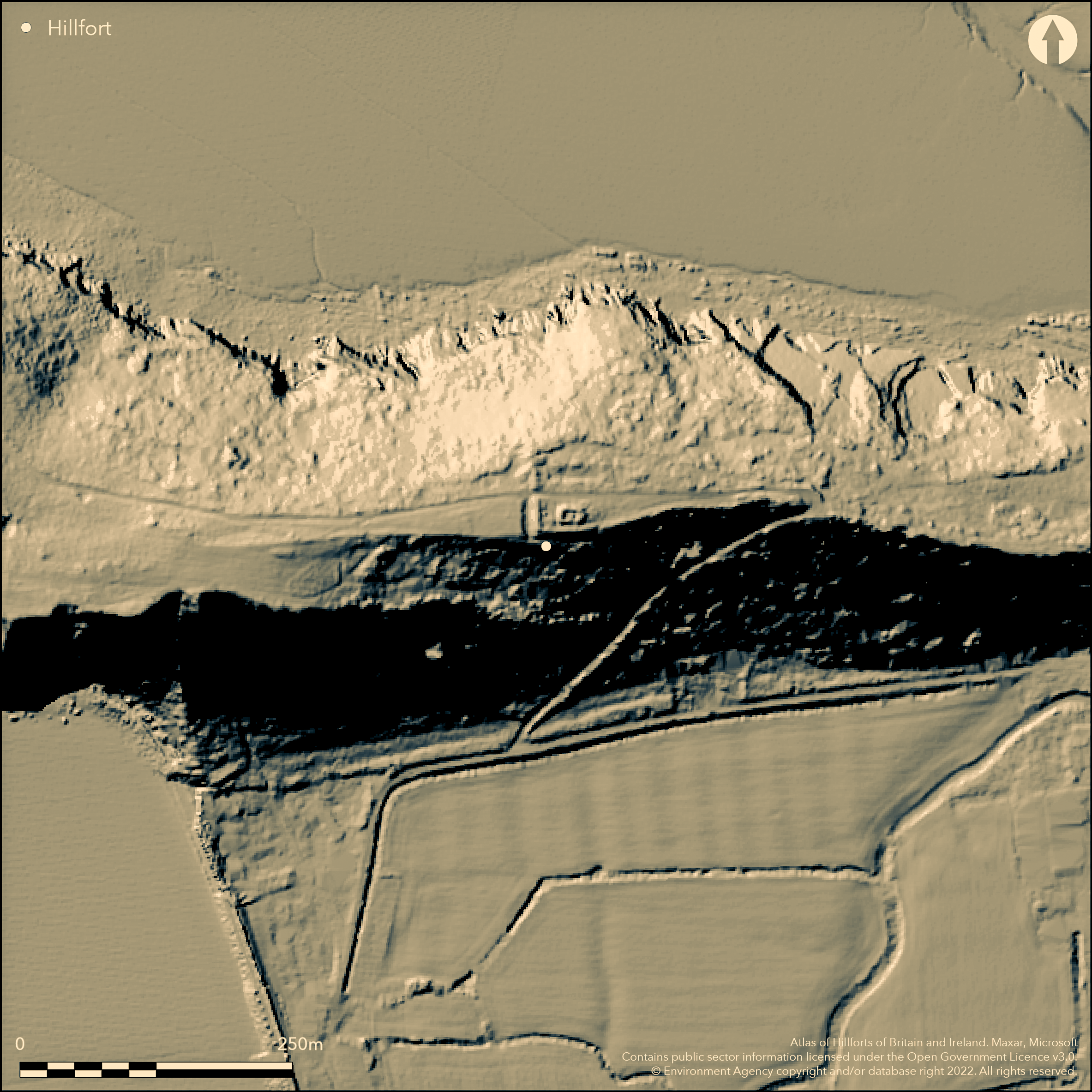
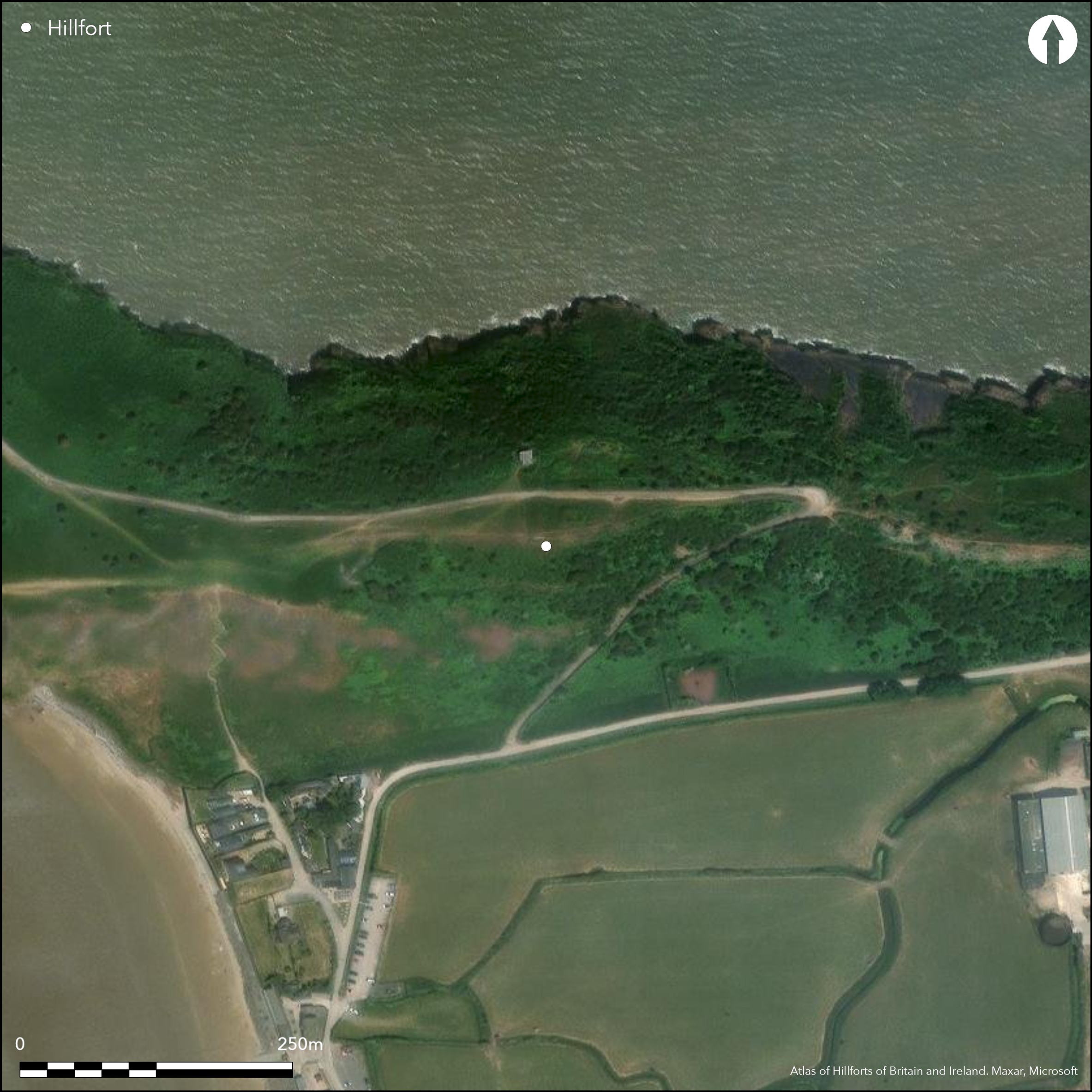
Contour hillfort located on a Carboniferous Limestone ridge, isolated from Mendip by River Axe estuary, overlooking the sea directly to the N at the E end of the Brean Down peninsula, the S promontory of Weston Bay. On 1st Ed OS map (1885-1900). Brean Down has evidence of activity extending from the Neolithic to WWII and all features are scheduled under one number including the Iron Age hillfort. Much disturbed by 20th century military buildings and road, which cuts through rampart on the W, and quarrying for limestone. Now L-shaped as a result of this damage, a stone bank c. 2.4m high with outer ditch running N-S across the ridge and ending at a steep slope on the N. To the S the rampart uses the natural rock outcrop for much of its length before turning E where generally destroyed. Narrow ledge fronts S rampart at W end. Bank and ditch best preserved on W and W end of S. Ditch present on outer side of S end of W rampart for 25m to 1.5m depth. Before quarrying in the 18th/19th century described as a 'square' earthwork and this, together with Roman finds, has resulted in a Roman origin suggested. However, a small excavation at the SW angle in 1974 (Burrow 1976) found with radio-carbon dating that the ramparts were constructed in late Iron Age; Iron Age pottery also being in use prior to rampart construction and whilst ditch silting was taking place. At this point excavation showed the rampart to be rubble banks revetted front and rear with massive drystone walling and ditch to W.
Citizen Science: ✗
Reliability of Data: Confirmed
Reliability of Interpretation: Confirmed
X: -334963 Y: 6678869 (EPSG: 3857)
Longitude: -3.0090235313961884 Latitude: 51.32434865179746 (EPSG:4326)
Country: England
Current County or Unitary Authority: Somerset
Historic County: Somerset
Current Parish/Community/Council/Townland: Brean
Much disturbed by 20th century military buildings and road, which cuts through rampart on the W, and quarrying for limestone.
| Extant | ✓ |
| Cropmark | ✗ |
| Likely Destroyed | ✓ |
WWII building remains, quarrying, road construction. SSSI.
| Woodland | ✗ |
| Commercial Forestry Plantation | ✗ |
| Parkland | ✗ |
| Pasture (Grazing) | ✓ |
| Arable | ✗ |
| Scrub/Bracken | ✓ |
| Bare Outcrop | ✗ |
| Heather/Moorland | ✗ |
| Heath | ✗ |
| Built-up | ✓ |
| Coastal Grassland | ✗ |
| Other | ✓ |
Contour hillfort located on a Carboniferous Limestone ridge, isolated from Mendip by River Axe estuary, overlooking the sea directly to the N at the E end of the Brean Down peninsula, the S promontory of Weston Bay.
| Contour Fort | ✓ |
| Partial Contour Fort | ✗ |
| Promontory Fort | ✗ |
| Hillslope Fort | ✗ |
| Level Terrain Fort | ✗ |
| Marsh Fort | ✗ |
| Multiple Enclosure Fort | ✗ |
| Hilltop | ✗ |
| Coastal Promontory | ✗ |
| Inland Promontory | ✗ |
| Valley Bottom | ✗ |
| Knoll/Hillock/Outcrop | ✗ |
| Ridge | ✓ |
| Cliff/Plateau-edge/Scarp | ✗ |
| Hillslope | ✗ |
| Lowland | ✗ |
| Spur | ✗ |
Dominant Topographic Feature: Limestone ridge.
| North | ✗ |
| Northeast | ✗ |
| East | ✗ |
| Southeast | ✗ |
| South | ✗ |
| Southwest | ✗ |
| West | ✗ |
| Northwest | ✗ |
| Level | ✓ |
Altitude: 50.0m
N/A
Radio-carbon dating showed late Iron Age date for construction of ramparts 100+- 100BC, obtained from ditch deposits. Iron Age site possibly preceded by unenclosed phase. Roman pottery gold coins and ring show later Roman reuse of original Iron Age site. Substantial later use as quarrying for limestone and WWII occupancy, including building and road construction on site.
Reliability: B - Medium
| Pre 1200BC | ✗ |
| 1200BC - 800BC | ✗ |
| 800BC - 400BC | ✗ |
| 400BC - AD50 | ✓ |
| AD50 - AD400 | ✗ |
| AD400 - AD 800 | ✗ |
| Post AD800 | ✗ |
| Unknown | ✗ |
| Pre Hillfort: | None |
| Post Hillfort: | None |
| Artefactual: | Later Roman reuse of original Iron Age fort. |
| C14: | None |
On 1st Ed OS map (1885-1900). RCHME survey as part of general Brean Down survey, ref. no. 1086579. Small excavation at SW angle 1974 (Burrow 1976).
| Earthwork Survey (1965): | RCAHME survey as part of Brean Down survey. |
| Excavation (1974): | Small excavation at SW angle. |
| 1st Identified Map Depiction (None): | 1st Ed OS map |
Roman pottery, gold coins and ring. Iron Age pottery.
None
| None | ✓ |
| Spring | ✗ |
| Stream | ✗ |
| Pool | ✗ |
| Flush | ✗ |
| Well | ✗ |
| Other | ✗ |
None
| No Known Features | ✓ |
| Round Stone Structures | ✗ |
| Rectangular Stone Structures | ✗ |
| Curvilinear Platforms | ✗ |
| Other Roundhouse Evidence | ✗ |
| Pits | ✗ |
| Quarry Hollows | ✗ |
| Other | ✗ |
No interior excavation.
| No Known Excavation | ✓ |
| Pits | ✗ |
| Postholes | ✗ |
| Roundhouses | ✗ |
| Rectangular Structures | ✗ |
| Roads/Tracks | ✗ |
| Quarry Hollows | ✗ |
| Other | ✗ |
| Nothing Found | ✗ |
None
| No Known Geophysics | ✓ |
| Pits | ✗ |
| Roundhouses | ✗ |
| Rectangular Structures | ✗ |
| Roads/Tracks | ✗ |
| Quarry Hollows | ✗ |
| Other | ✗ |
| Nothing Found | ✗ |
Roman pottery, gold coins and ring. Iron Age pottery.
| No Known Finds | ✗ |
| Pottery | ✓ |
| Metal | ✓ |
| Metalworking | ✗ |
| Human Bones | ✗ |
| Animal Bones | ✗ |
| Lithics | ✗ |
| Environmental | ✗ |
| Other | ✗ |
None
| APs Not Checked | ✓ |
| None | ✗ |
| Roundhouses | ✗ |
| Rectangular Structures | ✗ |
| Pits | ✗ |
| Postholes | ✗ |
| Roads/Tracks | ✗ |
| Other | ✗ |
Much perimeter destuction preclude entrance location. SW breach for footpath.
| 1: | SW breach for footpath possibly modern, but could follow original route - not determined. |
| 2: | Original entrance not determined. |
Guard Chambers: ✗
Chevaux de Frise: ✗
Now L-shaped as a result of this damage, a stone bank c. 2.4m high with outer ditch running N-S across the ridge and ending at a steep slope on the N. To the S rampart uses the natural rock outcrop for much of its length before turning E where generally destroyed. Narrow ledge fronts S rampart at W end. Bank and ditch best preserved on W and W end of S. Ditch present on outer side of S end of W rampart for 25m to 1.5m depth and 3.5m wide. To N of road military building disturbed ditch. Excavation at the SW angle in 1974 showed the defences to be rubble banks revetted with front and rear, with massive drystone walling and with a ditch to the W.
| Area 1: | 4.0ha. |
| Total: | 4.0ha. |
Total Footprint Area: Noneha.
None
| ✗ | None |
| ✗ | Rampart destroyed on E. |
| NE Quadrant: | 0 |
| SE Quadrant: | 0 |
| SW Quadrant: | 1 |
| NW Quadrant: | 1 |
| Total: | 1 |
| Partial Univallate | ✓ |
| Univallate | ✗ |
| Partial Bivallate | ✗ |
| Bivallate | ✗ |
| Partial Multivallate | ✗ |
| Multivallate | ✗ |
| Unknown | ✗ |
| Partial Univallate | ✗ |
| Univallate | ✗ |
| Partial Bivallate | ✗ |
| Bivallate | ✗ |
| Partial Multivallate | ✗ |
| Multivallate | ✗ |
None
| None | ✗ |
| Earthen Bank | ✓ |
| Stone Wall | ✗ |
| Rubble | ✓ |
| Wall-walk | ✗ |
| Evidence of Timber | ✗ |
| Vitrification | ✗ |
| Other Burning | ✗ |
| Palisade | ✗ |
| Counter Scarp Bank | ✗ |
| Berm | ✗ |
| Unfinished | ✗ |
| Other | ✗ |
At SW angle excavation showed defences to be rubble banks revetted with front and rear with massive drystone walling and with a ditch to the W.
| None | ✗ |
| Earthen Bank | ✓ |
| Stone Wall | ✓ |
| Murus Duplex | ✗ |
| Timber-framed | ✗ |
| Timber-laced | ✗ |
| Vitrification | ✗ |
| Other Burning | ✗ |
| Palisade | ✗ |
| Counter Scarp Bank | ✗ |
| Berm | ✗ |
| Unfinished | ✗ |
| No Known Excavation | ✗ |
| Other | ✗ |
| ✗ | None |
| ✓ | Ditch much damaged by quarrying and military activity. Outer ditch running N-S across the ridge and ending at a steep slope on the N. Ditch best preserved on W and W end of S. Ditch present on outer side of S end of W rampart for 25m to 1.5m depth and 3.5m wide. To N of road military building disturbed ditch. Excavation at the SW angle in 1974 showed the defences rubble banks revetted with massive drystone walling and ditch to W. |
Number of Ditches: 1
| ✗ | None |
Burrow, I.G.C. 1976. Brean Down hillfort, Somerset, 1974, Proc Univ Bristol Spaeolog Soc, 14, (2), 141-54.
Page, W. (ed) 1911. The Victoria County History of the County of Somerset, 2, 472, London: St Catherine Press.
Atlas of Hillforts:
Wikidata:
This work is licensed under CC BY-SA 4.0![]()
![]()
![]() and should be cited as:
and should be cited as:
Lock, Gary and Ralston, Ian. 2024. Atlas of Hillforts of Britain and Ireland. Available at: https://hillforts.arch.ox.ac.uk
Document Version 1.1