LiDAR 1m DTM Hillshade
Satellite Imagery
LiDAR 1m DTM Hillshade
Satellite Imagery
Scroll left/right to view further images.
HER: Somerset 11113 (None)
NMR: ST 35 SW 1 (192590)
SM: 1008248
NGR: ST341509
X: 334100 Y: 150900 (OSGB36)
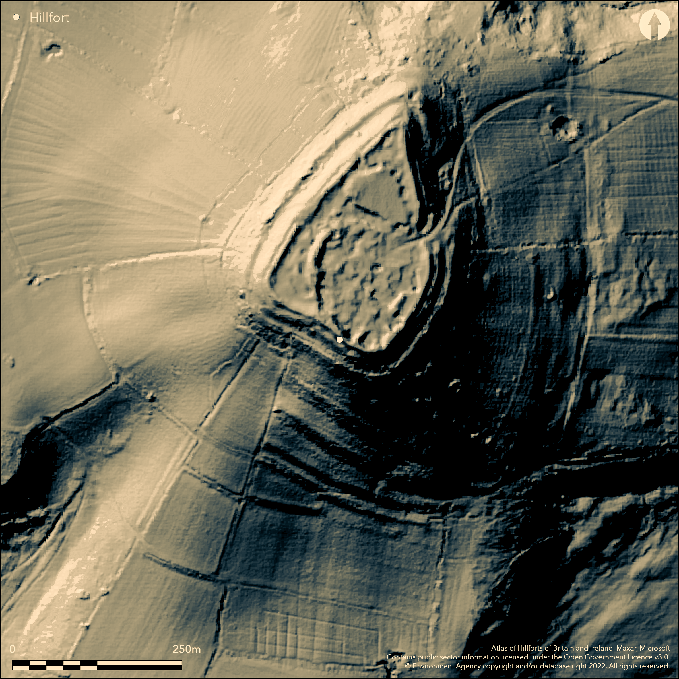
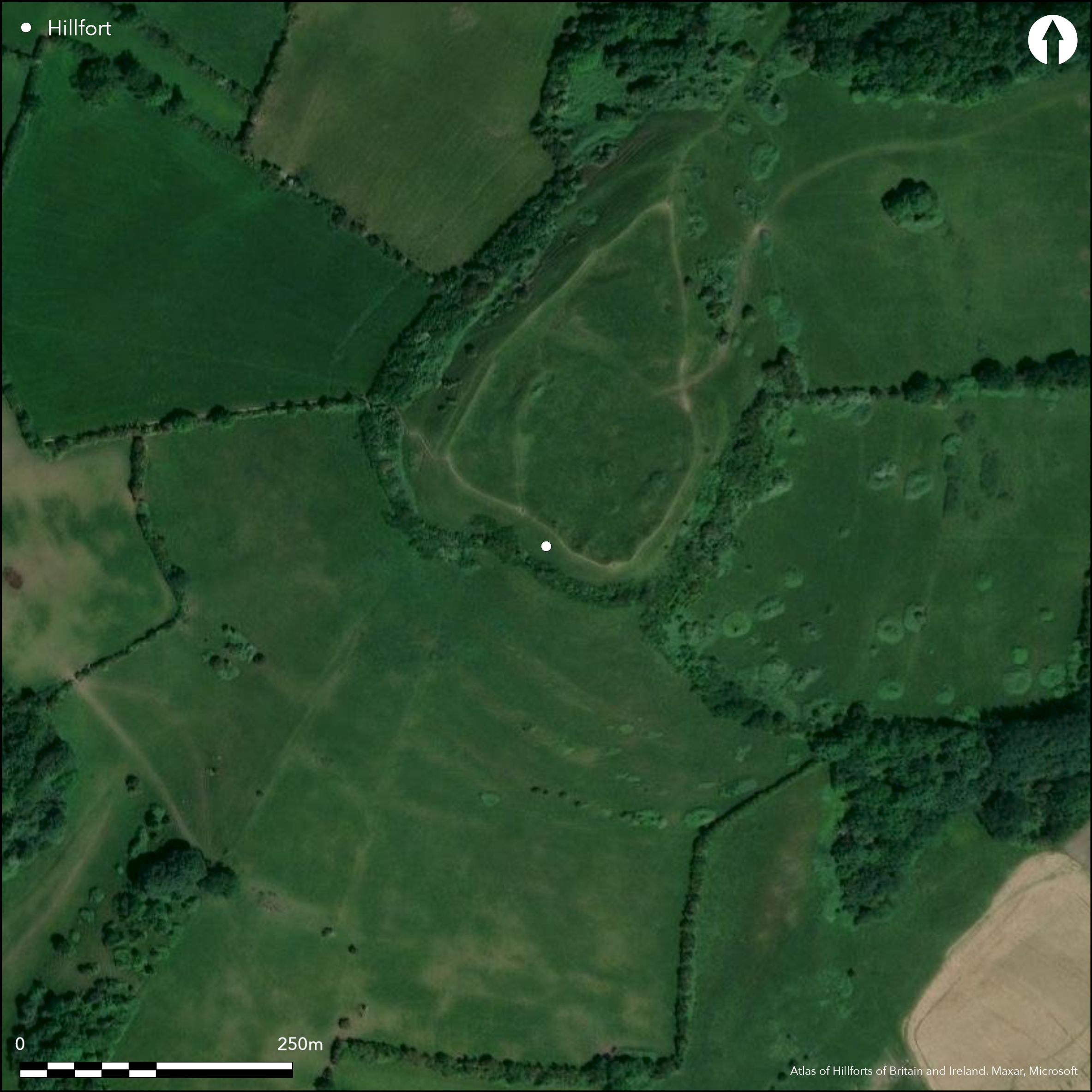
Large contour hillfort located on the flat top of Brent Knoll, an island hill in the surrounding levels of Sedgemoor, overlooking large areas to the Bristol Channel to the N. On 1st Ed OS map (1885-1900). Low rampart of c. 1m with internal quarry ditch enclose the hill, with external face falling steeply by c. 2m to step 2.75m wide beyond which falls to wider outer terrace c. 4-6m wide which probably represents remains of an outer ditch plus counterscarp bank. The land then falls to the base of the slope. No outer terrace to N, possibly suggesting unfinished. Rampart of stone or rubble construction, and between two terraces rough stone facing and line of cut stones visible. 35m of inner rampart to W levelled or tumbled. E entrance with narrow original hollow way up slope from below, reused later as quarry track into fort. Later hollow way from field below crosses this. Slight inturns to entrance and on outer side possible guard chambers, one D-shaped 12m by 8m and one crescent-shaped 11m by 8m. To N end another gap could be original and associated with bastians and additional rampart possibly guarding this N approach. Medieval quarrying affected interior but area of surface not affected to N and SW. The quarry hollows to the W and NE inside rampart are original. 'Antique' part excavations in 19th century by Rev Skinner of dark occupation soil to W provided evidence of Roman activity with building debris, coins, Samian and other sherds, charcoal and human remains. 18th/19th century reference to Roman coin hoard of Severus and Trajan and other Roman artefacts. Later other Iron Age and Romano-British pottery found.
Citizen Science: ✗
Reliability of Data: Confirmed
Reliability of Interpretation: Confirmed
X: -327915 Y: 6666238 (EPSG: 3857)
Longitude: -2.945708454676244 Latitude: 51.25338868723968 (EPSG:4326)
Country: England
Current County or Unitary Authority: Somerset
Historic County: Somerset
Current Parish/Community/Council/Townland: East Brent
Damaged by medieval quarrying in interior and WWII Home Guard slit trenches with revetment, gun emplacement and other activity. Jubilee stone and flag mast.
| Extant | ✓ |
| Cropmark | ✗ |
| Likely Destroyed | ✗ |
Medieval quarrying in interior and WWII Home Guard slit trenches with revetment, gun emplacement and other activity. Jubilee stone and flag mast.
| Woodland | ✓ |
| Commercial Forestry Plantation | ✗ |
| Parkland | ✗ |
| Pasture (Grazing) | ✗ |
| Arable | ✗ |
| Scrub/Bracken | ✓ |
| Bare Outcrop | ✗ |
| Heather/Moorland | ✗ |
| Heath | ✗ |
| Built-up | ✗ |
| Coastal Grassland | ✗ |
| Other | ✓ |
Large contour hillfort located on flat top of Brent Knoll, an island hill in the surrounding levels of Sedgemoor, overlooking large areas to the Bristol Channel to the N.
| Contour Fort | ✓ |
| Partial Contour Fort | ✗ |
| Promontory Fort | ✗ |
| Hillslope Fort | ✗ |
| Level Terrain Fort | ✗ |
| Marsh Fort | ✗ |
| Multiple Enclosure Fort | ✗ |
| Hilltop | ✓ |
| Coastal Promontory | ✗ |
| Inland Promontory | ✗ |
| Valley Bottom | ✗ |
| Knoll/Hillock/Outcrop | ✗ |
| Ridge | ✗ |
| Cliff/Plateau-edge/Scarp | ✗ |
| Hillslope | ✗ |
| Lowland | ✗ |
| Spur | ✗ |
Dominant Topographic Feature: Brent Knoll summit.
| North | ✗ |
| Northeast | ✗ |
| East | ✗ |
| Southeast | ✗ |
| South | ✗ |
| Southwest | ✗ |
| West | ✗ |
| Northwest | ✗ |
| Level | ✓ |
Altitude: 139.0m
N/A
'Antique' part excavations in 19th century by Rev Skinner of dark occupation soil to W provided evidence of Roman activity with building debris, coins, Samian and other sherds, charcoal and human remains. 18th/19th century reference to Roman coin hoard of Severus and Trajan and other Roman artefacts. Later other Iron and and Romano-British pottery found.
Reliability: C - Low
| Pre 1200BC | ✗ |
| 1200BC - 800BC | ✗ |
| 800BC - 400BC | ✗ |
| 400BC - AD50 | ✓ |
| AD50 - AD400 | ✗ |
| AD400 - AD 800 | ✗ |
| Post AD800 | ✗ |
| Unknown | ✗ |
| Pre Hillfort: | None |
| Post Hillfort: | None |
| Artefactual: | Iron Age, Romano-British and Roman pottery and other artefacts. |
| Other: | Medieval quarrying and WWII Home Guard activity. |
In Aubrey's Monumenta Britannica (1665-1693). On 1st Ed OS map (1885-1900). 19th century excavation by Rev J. Skinner. Surface examination and site search - details unknown. Measured survey - Defence of Britain Project. Aerial and geophysical surveys. Small post hole 2004.
| Other (1972): | Surface examination and site search - details unknown. |
| Geophysical Survey (2004): | S. and S . Driscoll. |
| Excavation (2004): | Post hole re Easter crosses. |
| 1st Identified Written Reference (None): | None |
| 1st Identified Map Depiction (None): | 1st Ed OS |
| Other (None): | RCAHME Aerial Photograph Primary Record Project. |
| Other (None): | Measured survey - Defence of Britain Project. |
| Excavation (None): | Rev J. Skinner |
19th century excavation of dark occupation layer to W side of fort. RCAHME aerial surveys 1992-96- details not determined. 2004 geophysical surveys by S. Driscoll and S. Driscoll - details not determined. Evidence of Roman activity with building debris, coins, Samian and other sherds, charcoal and human remains. 18th/19th century reference to Roman coin hoard of Severus and Trajan and other Roman artefacts. Flint arrowhead. Later other Iron Age and and Romano-British pottery found. Three small post holes 2004 produced fragments of abraded Roman pottery, small fragments of bone, brick and burnt limestone.
None
| None | ✓ |
| Spring | ✗ |
| Stream | ✗ |
| Pool | ✗ |
| Flush | ✗ |
| Well | ✗ |
| Other | ✗ |
None
| No Known Features | ✗ |
| Round Stone Structures | ✗ |
| Rectangular Stone Structures | ✗ |
| Curvilinear Platforms | ✗ |
| Other Roundhouse Evidence | ✗ |
| Pits | ✗ |
| Quarry Hollows | ✓ |
| Other | ✗ |
19th century excavation of dark occupation layer to W side of fort.
| No Known Excavation | ✗ |
| Pits | ✗ |
| Postholes | ✗ |
| Roundhouses | ✗ |
| Rectangular Structures | ✗ |
| Roads/Tracks | ✗ |
| Quarry Hollows | ✗ |
| Other | ✓ |
| Nothing Found | ✗ |
2004 geophysical surveys by S. Driscoll and S. Driscoll - details not determined.
| No Known Geophysics | ✗ |
| Pits | ✗ |
| Roundhouses | ✗ |
| Rectangular Structures | ✗ |
| Roads/Tracks | ✗ |
| Quarry Hollows | ✗ |
| Other | ✓ |
| Nothing Found | ✗ |
Evidence of Roman activity with building debris, coins, Samian and other sherds, charcoal and human remains. 18th/19th century reference to Roman coin hoard of Severus and Trajan and other Roman artefacts. Flint arrowhead. Later other Iron and and Romano-British pottery found. Three small post holes 2004 produced fragments of abraded Roman pottery, small fragments of bone, brick and burnt limestone.
| No Known Finds | ✗ |
| Pottery | ✓ |
| Metal | ✗ |
| Metalworking | ✗ |
| Human Bones | ✓ |
| Animal Bones | ✗ |
| Lithics | ✓ |
| Environmental | ✓ |
| Other | ✓ |
RCAHME aerial surveys 1992-96- details not determined.
| APs Not Checked | ✓ |
| None | ✗ |
| Roundhouses | ✗ |
| Rectangular Structures | ✗ |
| Pits | ✗ |
| Postholes | ✗ |
| Roads/Tracks | ✗ |
| Other | ✗ |
E entrance with narrow original hollow way up slope from below, reused later as a quarry track into fort. Later hollow way from field below crosses this. Slight inturns to entrance and on outer side possible guard chambers, one D-shaped 12m by 8m and one crescent-shaped 11m by 8m. To N end another gap could be original and associated with bastians and additional rampart possibly guarding this N approach.
| 2: | None |
| 2: | None |
Guard Chambers: ✓
Chevaux de Frise: ✗
| 1. Hollow Way (East): | Possible guard chambers. |
| 1. Recesses/Guard Chambers (East): | Possible guard chambers, one D-shaped 12m by 8m and one crescent-shaped 11m by 8m. |
| 1. In-turned (East): | Slight inturns. |
| 2. Simple Gap (North): | Possible embellishments below. |
| 2. Outworks (North): | Associated with bastians and additional rampart possibly guarding this N approach. |
Low rampart of c. 1m with internal quarry ditch enclose the hill, with the external face falling steeply by c. 2m to step 2.75m wide beyond which falls to wider outer terrace c. 4-6m wide which probably represents the remains of an outer ditch plus counterscarp bank. The land then falls to the base of the slope. There is no outer terrace to the N, possibly suggesting unfinished. Rampart of stone or rubble construction, and between two terraces rough stone facing and line of cut stones visible. 35m of inner rampart to W levelled or tumbled.
| Area 1: | 2.1ha. |
| Total: | 2.1ha. |
Total Footprint Area: Noneha.
None
| ✗ | None |
| ✓ | None |
| NE Quadrant: | 1 |
| SE Quadrant: | 1 |
| SW Quadrant: | 1 |
| NW Quadrant: | 1 |
| Total: | 1 |
| Partial Univallate | ✗ |
| Univallate | ✓ |
| Partial Bivallate | ✗ |
| Bivallate | ✗ |
| Partial Multivallate | ✗ |
| Multivallate | ✗ |
| Unknown | ✗ |
| Partial Univallate | ✗ |
| Univallate | ✗ |
| Partial Bivallate | ✗ |
| Bivallate | ✗ |
| Partial Multivallate | ✗ |
| Multivallate | ✗ |
None
| None | ✗ |
| Earthen Bank | ✗ |
| Stone Wall | ✓ |
| Rubble | ✓ |
| Wall-walk | ✗ |
| Evidence of Timber | ✗ |
| Vitrification | ✗ |
| Other Burning | ✗ |
| Palisade | ✗ |
| Counter Scarp Bank | ✓ |
| Berm | ✗ |
| Unfinished | ✓ |
| Other | ✗ |
None
| None | ✓ |
| Earthen Bank | ✗ |
| Stone Wall | ✗ |
| Murus Duplex | ✗ |
| Timber-framed | ✗ |
| Timber-laced | ✗ |
| Vitrification | ✗ |
| Other Burning | ✗ |
| Palisade | ✗ |
| Counter Scarp Bank | ✗ |
| Berm | ✗ |
| Unfinished | ✗ |
| No Known Excavation | ✗ |
| Other | ✗ |
| ✗ | None |
| ✓ | Wider outer terrace c. 4-6m wide downslope probably represents the remains of an outer ditch plus counterscarp bank. |
Number of Ditches: 1
| ✗ | None |
Burrow, E.J. 1924. Ancient earthworks and camps of Somerset, Cheltenham: E.J. Burrow, 66-67.
Page, W. (ed) 1911. The Victoria County History of the County of Somerset, 2, 483, London: St Catherine Press.
Atlas of Hillforts:
Wikidata:
This work is licensed under CC BY-SA 4.0![]()
![]()
![]() and should be cited as:
and should be cited as:
Lock, Gary and Ralston, Ian. 2024. Atlas of Hillforts of Britain and Ireland. Available at: https://hillforts.arch.ox.ac.uk
Document Version 1.1