LiDAR 1m DTM Hillshade
Satellite Imagery
LiDAR 1m DTM Hillshade
Satellite Imagery
Scroll left/right to view further images.
HER: Somerset 23442 (None)
NMR: ST 74 NW 1 (202769)
SM: 1006163
NGR: ST744488
X: 374400 Y: 148800 (OSGB36)
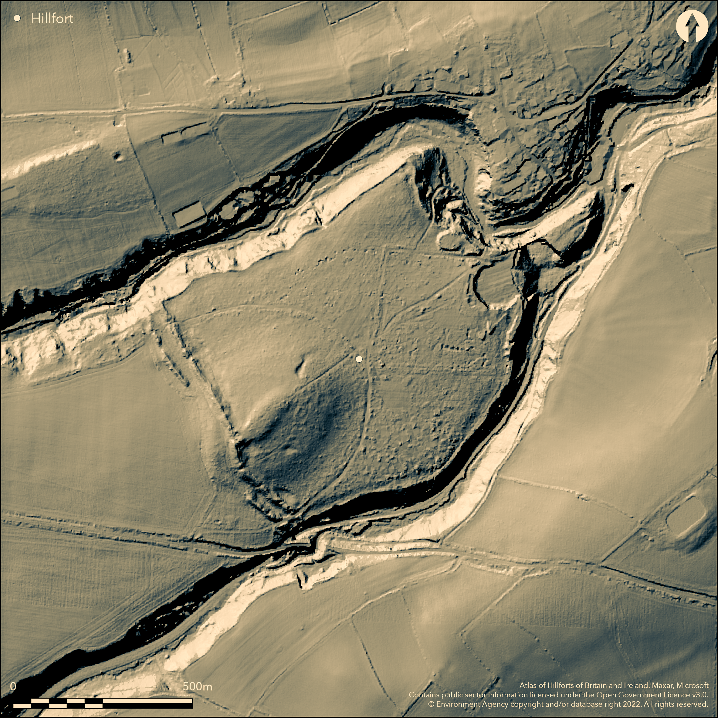
Very large promontory fort of 26ha sited on limestone spur above confluence of Mells Stream and Fordbury Water. On 1st Ed OS map (1885-1900). Two parallel banks cut off the promontory NW-SE. Only 94m of outer bank at SE end and 150m at NW end remain. Inner bank mostly complete 3m-4.7m high, with remains of 1.2m-1.8m thick dry-stone wall formerly running from SE end for distance, but now only visible in two places, where there are also traces of third bank. However, possible that this wall could be similar to that formerly enclosing the wood within the W end of the fort. Although it has been suggested that an entrance could be in the centre, none visible and position at S terminal more likely, but much quarried away here, although vestiges of the third rampart remain. Minimal investigations.
Citizen Science: ✓
Reliability of Data: Confirmed
Reliability of Interpretation: Confirmed
X: -263616 Y: 6663457 (EPSG: 3857)
Longitude: -2.36810600031894 Latitude: 51.23774655097802 (EPSG:4326)
Country: England; None
Current County or Unitary Authority: Somerset
Historic County: Somerset
Current Parish/Community/Council/Townland: Great Elm; Mells
Affected by past limestone quarrying. Outer bank much reduced.
| Extant | ✓ |
| Cropmark | ✗ |
| Likely Destroyed | ✗ |
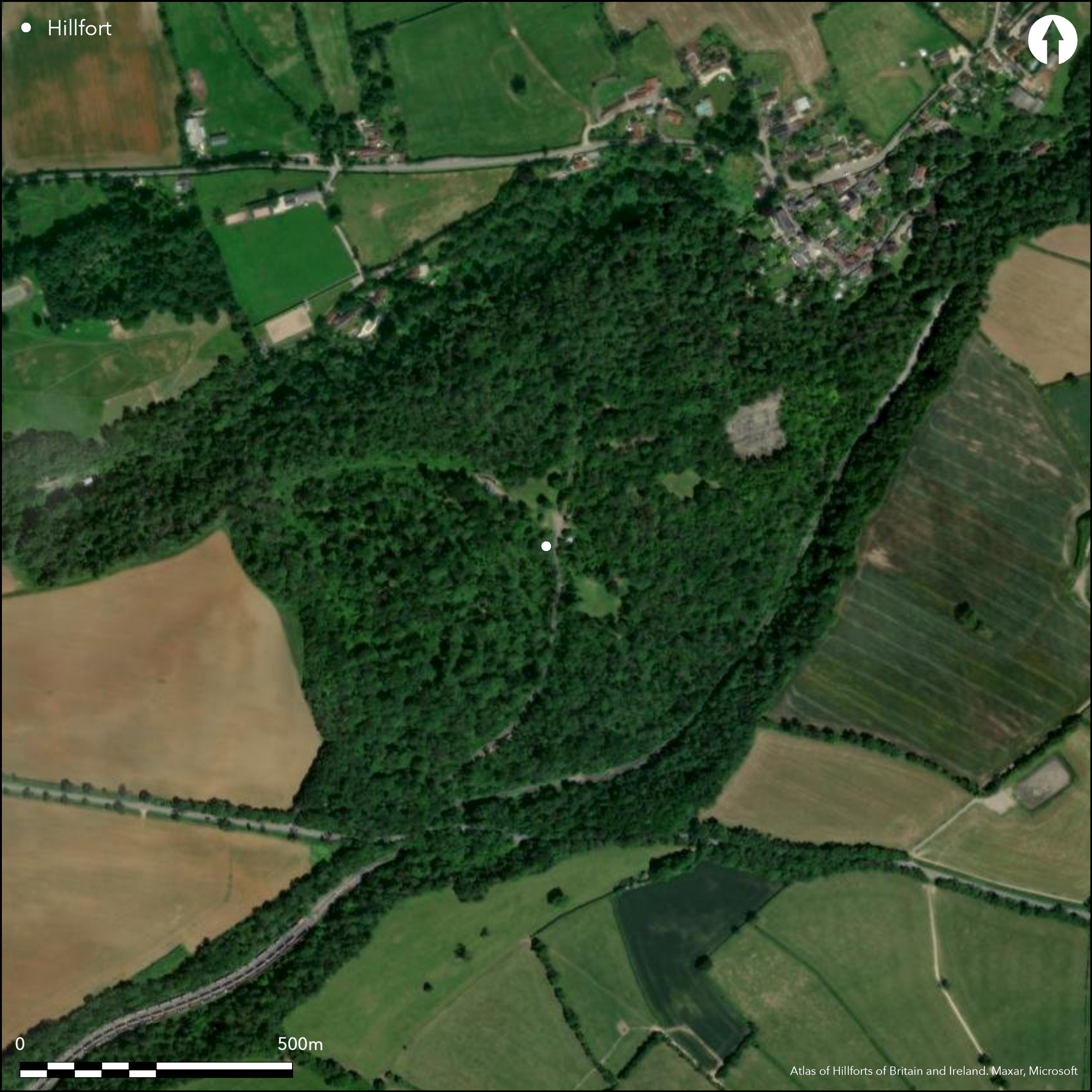
Now sited within Tedbury Covert. One part pasture. Quarrying.
| Woodland | ✓ |
| Commercial Forestry Plantation | ✗ |
| Parkland | ✗ |
| Pasture (Grazing) | ✗ |
| Arable | ✗ |
| Scrub/Bracken | ✗ |
| Bare Outcrop | ✗ |
| Heather/Moorland | ✗ |
| Heath | ✗ |
| Built-up | ✗ |
| Coastal Grassland | ✗ |
| Other | ✓ |
Very large promontory fort of 26ha sited on limestone spur above confluence of Mells Stream and Fordbury Water.
| Contour Fort | ✗ |
| Partial Contour Fort | ✗ |
| Promontory Fort | ✓ |
| Hillslope Fort | ✗ |
| Level Terrain Fort | ✗ |
| Marsh Fort | ✗ |
| Multiple Enclosure Fort | ✗ |
| Hilltop | ✗ |
| Coastal Promontory | ✗ |
| Inland Promontory | ✓ |
| Valley Bottom | ✗ |
| Knoll/Hillock/Outcrop | ✗ |
| Ridge | ✗ |
| Cliff/Plateau-edge/Scarp | ✗ |
| Hillslope | ✗ |
| Lowland | ✗ |
| Spur | ✓ |
Dominant Topographic Feature: Limestone spur
| North | ✗ |
| Northeast | ✓ |
| East | ✗ |
| Southeast | ✗ |
| South | ✗ |
| Southwest | ✗ |
| West | ✗ |
| Northwest | ✗ |
| Level | ✗ |
Altitude: 120.0m
Boundary Type: Parish/Townland
Rotary quern found c. 1939-45 when overburden cleared from E end of site and pot of Roman coins found 1691 - possibly Constantine, could indicate some later Roman influence, but site date unknown.
Reliability: D - None
| Pre 1200BC | ✗ |
| 1200BC - 800BC | ✗ |
| 800BC - 400BC | ✗ |
| 400BC - AD50 | ✗ |
| AD50 - AD400 | ✗ |
| AD400 - AD 800 | ✗ |
| Post AD800 | ✗ |
| Unknown | ✓ |
| Pre Hillfort: | None |
| Post Hillfort: | Possible Roman activity. |
On 1st Ed OS map (1885-1900). LiDAR survey Geomatics est 2006.
| 1st Identified Map Depiction (None): | 1st Ed OS |
| LiDAR Survey (None): | Geomatics. |
Rotary quern found c. 1939-45 when overburden cleared from E end of site. Pot of Roman coins found 1691 - possibly Constantine.
None
| None | ✓ |
| Spring | ✗ |
| Stream | ✗ |
| Pool | ✗ |
| Flush | ✗ |
| Well | ✗ |
| Other | ✗ |
None
| No Known Features | ✓ |
| Round Stone Structures | ✗ |
| Rectangular Stone Structures | ✗ |
| Curvilinear Platforms | ✗ |
| Other Roundhouse Evidence | ✗ |
| Pits | ✗ |
| Quarry Hollows | ✗ |
| Other | ✗ |
None
| No Known Excavation | ✓ |
| Pits | ✗ |
| Postholes | ✗ |
| Roundhouses | ✗ |
| Rectangular Structures | ✗ |
| Roads/Tracks | ✗ |
| Quarry Hollows | ✗ |
| Other | ✗ |
| Nothing Found | ✗ |
None
| No Known Geophysics | ✓ |
| Pits | ✗ |
| Roundhouses | ✗ |
| Rectangular Structures | ✗ |
| Roads/Tracks | ✗ |
| Quarry Hollows | ✗ |
| Other | ✗ |
| Nothing Found | ✗ |
Rotary quern found c. 1939-45 when overburden cleared from E end of site. Pot of Roman coins found 1691 - possibly Constantine.
| No Known Finds | ✓ |
| Pottery | ✗ |
| Metal | ✗ |
| Metalworking | ✗ |
| Human Bones | ✗ |
| Animal Bones | ✗ |
| Lithics | ✗ |
| Environmental | ✗ |
| Other | ✓ |
None
| APs Not Checked | ✓ |
| None | ✗ |
| Roundhouses | ✗ |
| Rectangular Structures | ✗ |
| Pits | ✗ |
| Postholes | ✗ |
| Roads/Tracks | ✗ |
| Other | ✗ |
Although it has been suggested that an entrance could be in the centre, none is visible and a position at the S terminal would be more likely, but much has been quarried away here, although vestiges of the third rampart remain.
| 0: | No entrance gaps visible. |
| 2: | Position at S terminal likely. |
Guard Chambers: ✗
Chevaux de Frise: ✗
| 1. Simple Gap (South): | Type of entrance not determined. Much quarried away.Simple gap default. |
Two parallel banks cut off the promontory NW-SE. Only 94m of outer bank at SE end and 150m at NW end remain. Inner bank mostly complete 3m-4.7m high, with remains of 1.2m-1.8m thick dry-stone wall formerly running from SE end for distance, but now only visible in two places, where there are also traces of third bank. However, it is possible that this wall could be similar to that enclosing the wood within the camp.
| Area 1: | 26.0ha. |
| Total: | 26.0ha. |
Total Footprint Area: Noneha.
None
| ✗ | None |
| ✗ | None |
| NE Quadrant: | 0 |
| SE Quadrant: | 3 |
| SW Quadrant: | 0 |
| NW Quadrant: | 2 |
| Total: | 3 |
| Partial Univallate | ✗ |
| Univallate | ✗ |
| Partial Bivallate | ✓ |
| Bivallate | ✗ |
| Partial Multivallate | ✓ |
| Multivallate | ✗ |
| Unknown | ✗ |
| Partial Univallate | ✗ |
| Univallate | ✗ |
| Partial Bivallate | ✗ |
| Bivallate | ✗ |
| Partial Multivallate | ✗ |
| Multivallate | ✗ |
None
| None | ✓ |
| Earthen Bank | ✗ |
| Stone Wall | ✗ |
| Rubble | ✗ |
| Wall-walk | ✗ |
| Evidence of Timber | ✗ |
| Vitrification | ✗ |
| Other Burning | ✗ |
| Palisade | ✗ |
| Counter Scarp Bank | ✗ |
| Berm | ✗ |
| Unfinished | ✗ |
| Other | ✗ |
None
| None | ✓ |
| Earthen Bank | ✗ |
| Stone Wall | ✗ |
| Murus Duplex | ✗ |
| Timber-framed | ✗ |
| Timber-laced | ✗ |
| Vitrification | ✗ |
| Other Burning | ✗ |
| Palisade | ✗ |
| Counter Scarp Bank | ✗ |
| Berm | ✗ |
| Unfinished | ✗ |
| No Known Excavation | ✗ |
| Other | ✗ |
| ✗ | None |
| ✓ | None |
Number of Ditches: 2
| ✗ | None |
Burrow, E.J. 1924. Ancient earthworks and camps of Somerset, Cheltenham: E.J. Burrow, 56-57.
Page, W. (ed) 1911. The Victoria County History of the County of Somerset, 2, 104-5, London: St Catherine Press.
Atlas of Hillforts:
Wikidata:
This work is licensed under CC BY-SA 4.0![]()
![]()
![]() and should be cited as:
and should be cited as:
Lock, Gary and Ralston, Ian. 2024. Atlas of Hillforts of Britain and Ireland. Available at: https://hillforts.arch.ox.ac.uk
Document Version 1.1