LiDAR 1m DTM Hillshade
Satellite Imagery
LiDAR 1m DTM Hillshade
Satellite Imagery
Scroll left/right to view further images.
HER: Somerset 23849 (None)
NMR: ST 75 SW 4 (203188)
SM: 1006219
NGR: ST71885172
X: 371880 Y: 151720 (OSGB36)
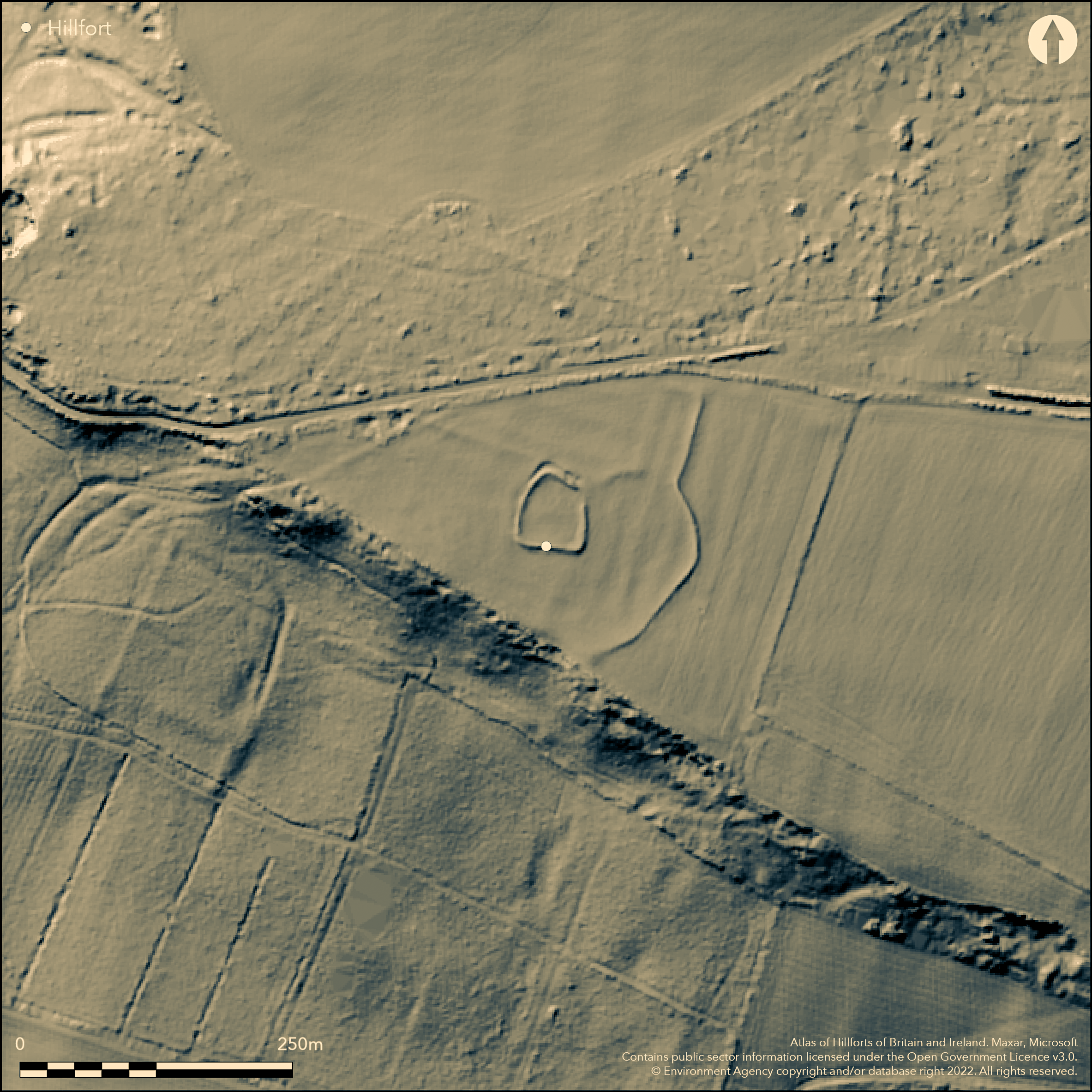
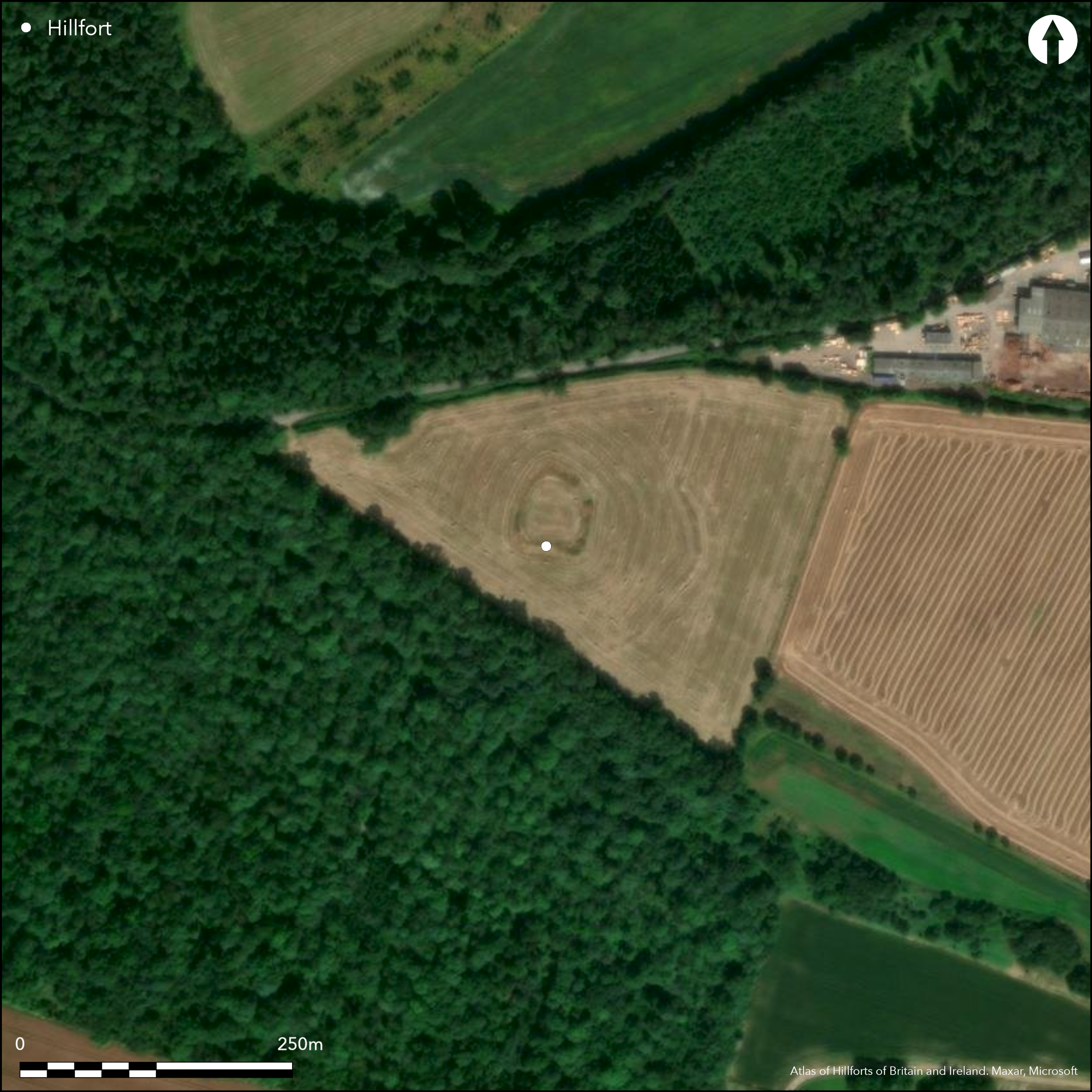
Small part contour hillfort sited on a SW facing spur of W Mells Down above the headwaters of the Mells River. On 1st Ed OS map (1885-1900). Excavation by H.St.G. Gray 1927-29 found a pre-Flavian dry-stone wall and v-shaped outer ditch and inner ditch. This enclosing wall, now concealed within a low bank, suggested by parched surface of the grass-covered banks in dry conditions and exposed stones in places. Surrounding ditch survives only on N and W sides; probably buried feature elsewhere. Two paved entrances found, an original of Iron Age date to SSE and later Roman entrance to NE with two gate post holes. Numerous finds from both ditches, including pottery of Iron Age to Roman date, Romano-British brooches, currency bars, Roman coins, human bone and Roman burials and iron slag. Occupation of the site continued into late first and second centuries AD.
Citizen Science: ✓
Reliability of Data: Confirmed
Reliability of Interpretation: Confirmed
X: -267660 Y: 6668105 (EPSG: 3857)
Longitude: -2.404432857109107 Latitude: 51.263883554894896 (EPSG:4326)
Country: England; None
Current County or Unitary Authority: Somerset
Historic County: Somerset
Current Parish/Community/Council/Townland: Mells; Kilmersdon
Nearly gone.
| Extant | ✓ |
| Cropmark | ✗ |
| Likely Destroyed | ✗ |
Downland pasture.
| Woodland | ✗ |
| Commercial Forestry Plantation | ✗ |
| Parkland | ✗ |
| Pasture (Grazing) | ✓ |
| Arable | ✗ |
| Scrub/Bracken | ✗ |
| Bare Outcrop | ✗ |
| Heather/Moorland | ✗ |
| Heath | ✗ |
| Built-up | ✗ |
| Coastal Grassland | ✗ |
| Other | ✗ |
Small partial contour hillfort sited on a SW facing spur of W Mells Down above the headwaters of the Mells River.
| Contour Fort | ✗ |
| Partial Contour Fort | ✓ |
| Promontory Fort | ✗ |
| Hillslope Fort | ✗ |
| Level Terrain Fort | ✗ |
| Marsh Fort | ✗ |
| Multiple Enclosure Fort | ✗ |
| Hilltop | ✗ |
| Coastal Promontory | ✗ |
| Inland Promontory | ✗ |
| Valley Bottom | ✗ |
| Knoll/Hillock/Outcrop | ✗ |
| Ridge | ✗ |
| Cliff/Plateau-edge/Scarp | ✗ |
| Hillslope | ✗ |
| Lowland | ✗ |
| Spur | ✓ |
Dominant Topographic Feature: Spur of Mells Down.
| North | ✗ |
| Northeast | ✗ |
| East | ✗ |
| Southeast | ✗ |
| South | ✗ |
| Southwest | ✓ |
| West | ✗ |
| Northwest | ✗ |
| Level | ✗ |
Altitude: 185.0m
Boundary Type: Parish/Townland
Excavations 1927-29 found numerous artefacts, indicating occupation in late Iron Age to later refortification in late 1st/2nd century AD.
Reliability: B - Medium
| Pre 1200BC | ✗ |
| 1200BC - 800BC | ✗ |
| 800BC - 400BC | ✗ |
| 400BC - AD50 | ✓ |
| AD50 - AD400 | ✗ |
| AD400 - AD 800 | ✗ |
| Post AD800 | ✗ |
| Unknown | ✗ |
| Pre Hillfort: | None |
| Post Hillfort: | None |
| Artefactual: | Excavations 1927-29 found many artefacts. |
On 1st Ed OS map (1885-1900). Excavation by H.St.G. Gray 1927-29.
| 1st Identified Map Depiction (None): | 1st Ed OS |
| Excavation (None): | H. St. G. Gray. |
Various banks and mounds of local stone examined - their nature not determined. Numerous finds including pottery of Iron Age to Roman date, Romano-British brooches, currency bars, Roman coins, human bone and Roman burials and iron slag.
None
| None | ✓ |
| Spring | ✗ |
| Stream | ✗ |
| Pool | ✗ |
| Flush | ✗ |
| Well | ✗ |
| Other | ✗ |
Inner quarry ditch. Various mounds and banks in evidence.
| No Known Features | ✗ |
| Round Stone Structures | ✗ |
| Rectangular Stone Structures | ✗ |
| Curvilinear Platforms | ✗ |
| Other Roundhouse Evidence | ✗ |
| Pits | ✗ |
| Quarry Hollows | ✓ |
| Other | ✓ |
Various banks and mounds of local stone examined - their nature not determined.
| No Known Excavation | ✗ |
| Pits | ✗ |
| Postholes | ✗ |
| Roundhouses | ✗ |
| Rectangular Structures | ✗ |
| Roads/Tracks | ✗ |
| Quarry Hollows | ✗ |
| Other | ✓ |
| Nothing Found | ✗ |
None
| No Known Geophysics | ✓ |
| Pits | ✗ |
| Roundhouses | ✗ |
| Rectangular Structures | ✗ |
| Roads/Tracks | ✗ |
| Quarry Hollows | ✗ |
| Other | ✗ |
| Nothing Found | ✗ |
Numerous finds from both ditches, including pottery of Iron Age to Roman date, Romano-British brooches, currency bars, Roman coins, human bone and Roman burials and iron slag.
| No Known Finds | ✗ |
| Pottery | ✓ |
| Metal | ✓ |
| Metalworking | ✓ |
| Human Bones | ✓ |
| Animal Bones | ✗ |
| Lithics | ✗ |
| Environmental | ✗ |
| Other | ✓ |
None
| APs Not Checked | ✓ |
| None | ✗ |
| Roundhouses | ✗ |
| Rectangular Structures | ✗ |
| Pits | ✗ |
| Postholes | ✗ |
| Roads/Tracks | ✗ |
| Other | ✗ |
Two paved entrances were found, an original of Iron Age date to the SSE and a later Roman entrance to the NE with two gate postholes.
| 2: | None |
| 2: | None |
Guard Chambers: ✗
Chevaux de Frise: ✗
| 1. Other Forms (South east): | Paved entrance. |
| 2. Other Forms (North east): | Roman paved entrance. |
Pre-Flavian drystone wall and v-shaped outer ditch and inner ditch. This enclosing wall, which is now concealed within a low bank, is also suggested by parched surface of the grass covered banks in dry conditions and exposed stones in places. The surrounding ditch survives only on the N and W sides; probably a buried feature elsewhere.
| Area 1: | 2.0ha. |
| Total: | 2.0ha. |
Total Footprint Area: Noneha.
None
| ✗ | None |
| ✓ | None |
| NE Quadrant: | 1 |
| SE Quadrant: | 1 |
| SW Quadrant: | 1 |
| NW Quadrant: | 1 |
| Total: | 1 |
| Partial Univallate | ✗ |
| Univallate | ✓ |
| Partial Bivallate | ✗ |
| Bivallate | ✗ |
| Partial Multivallate | ✗ |
| Multivallate | ✗ |
| Unknown | ✗ |
| Partial Univallate | ✗ |
| Univallate | ✗ |
| Partial Bivallate | ✗ |
| Bivallate | ✗ |
| Partial Multivallate | ✗ |
| Multivallate | ✗ |
None
| None | ✗ |
| Earthen Bank | ✓ |
| Stone Wall | ✓ |
| Rubble | ✓ |
| Wall-walk | ✗ |
| Evidence of Timber | ✗ |
| Vitrification | ✗ |
| Other Burning | ✗ |
| Palisade | ✗ |
| Counter Scarp Bank | ✗ |
| Berm | ✗ |
| Unfinished | ✗ |
| Other | ✗ |
Pre-Flavian dry-stone wall and v-shaped outer ditch and inner ditch.
| None | ✗ |
| Earthen Bank | ✗ |
| Stone Wall | ✓ |
| Murus Duplex | ✗ |
| Timber-framed | ✗ |
| Timber-laced | ✗ |
| Vitrification | ✗ |
| Other Burning | ✗ |
| Palisade | ✗ |
| Counter Scarp Bank | ✗ |
| Berm | ✗ |
| Unfinished | ✗ |
| No Known Excavation | ✗ |
| Other | ✗ |
| ✗ | None |
| ✓ | v-shaped outer ditch and inner quarry ditch. The surrounding ditch survives only on the N and W sides; probably a buried feature elsewhere. |
Number of Ditches: 1
| ✗ | None |
Burrow, I. 1981. Hillfort and hill-top settlement in Somerset in the first to eighth centuries AD, BAR British Series 1(1974) - 91, 260.
Gray, H.St.G. 1930. Excavations at Kingsdown Camp, Mells, Somerset, 1927-9, Archaeologia, 80, 59-98.
Atlas of Hillforts:
Wikidata:
This work is licensed under CC BY-SA 4.0![]()
![]()
![]() and should be cited as:
and should be cited as:
Lock, Gary and Ralston, Ian. 2024. Atlas of Hillforts of Britain and Ireland. Available at: https://hillforts.arch.ox.ac.uk
Document Version 1.1