LiDAR 1m DTM Hillshade
Satellite Imagery
LiDAR 1m DTM Hillshade
Satellite Imagery
Scroll left/right to view further images.
HER: Northumberland 1401 (None)
NMR: NT 92 NW 15 (2858)
SM: 1014930
NGR: NT 9488 2909
X: 394887 Y: 629090 (OSGB36)
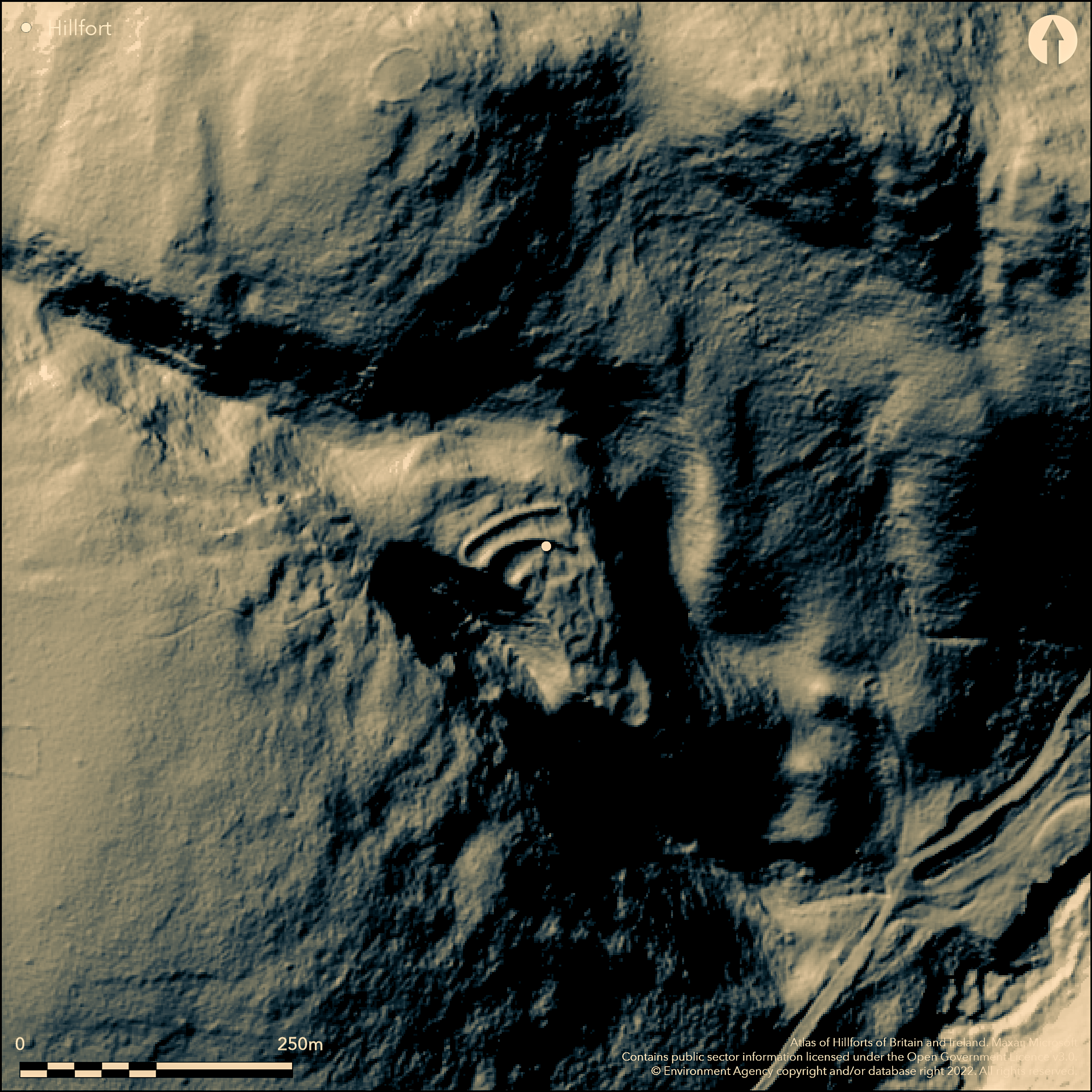
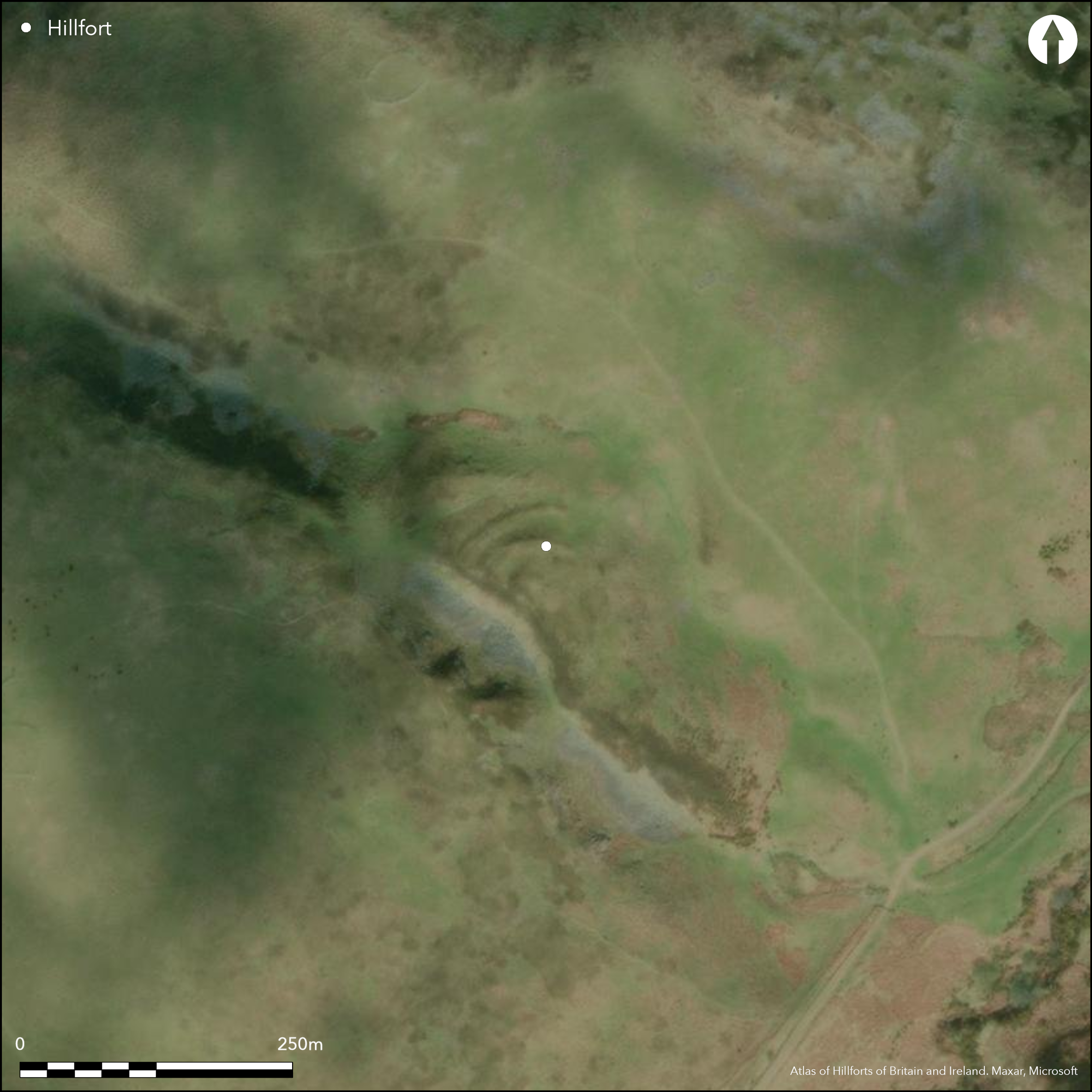
Lying to the SW of Akeld, a promontory fort on the summit of a spur on Akeld Hill. The naturally steep-sided promontory overlooks the valley of Akeld Burn in the S and is overlooked at close range from the W and by the higher ground to the N. The hillfort was constructed in two phases and was originally a univallate enclosure with a single bank running around the spur and cutting across the neck of the promontory in the N. A later phase saw two further ramparts constructed across the neck outside the original bank to enclose an area of 0.3ha. The original bank in the N was partially levelled at that time. The ramparts are of stone rubble construction and are now mostly grass covered. The innermost rampart is 50m long by 0.2-2m high and 6m wide. A U-shaped ditch 9m wide separates it from the middle rampart. The middle rampart is 67m long, up to 3m high and 10m wide. It is separated from the outer rampart by a flat bottomed ditch up to 4m wide. The outer rampart is 74m long by 5m wide and up to 2m high. It is revetted by large stones on both the inner and outer faces. An external ditch 2.5m wide by 0.4m deep lies outside the rampart with a slight counterscarp bank 3m wide. The original enclosure bank has now eroded in the NE corner and along an adjacent 50m long stretch in the E. A single entrance lies in the NE corner facing towards the natural line of approach. A further breach in the SE appears to be later although it was possibly constructed during the second phase. Up to fourteen scooped house platforms have been identified within the enclosure along terraces lying either side of a terraced trackway and overlying the line of the original rampart, although the accuracy of the interpretation has been questioned by a later surveys. Unrecorded on OS mapping until c.1980. Scheduled
Citizen Science: ✗
Reliability of Data: Confirmed
Reliability of Interpretation: Confirmed
X: -231834 Y: 7470434 (EPSG: 3857)
Longitude: -2.0826033280239247 Latitude: 55.55550916821393 (EPSG:4326)
Country: England
Current County or Unitary Authority: Northumberland
Historic County: Northumberland
Current Parish/Community/Council/Townland: Akeld
None
| Extant | ✓ |
| Cropmark | ✗ |
| Likely Destroyed | ✗ |
Rough grassland, possibly grazed
| Woodland | ✗ |
| Commercial Forestry Plantation | ✗ |
| Parkland | ✗ |
| Pasture (Grazing) | ✓ |
| Arable | ✗ |
| Scrub/Bracken | ✗ |
| Bare Outcrop | ✗ |
| Heather/Moorland | ✓ |
| Heath | ✗ |
| Built-up | ✗ |
| Coastal Grassland | ✗ |
| Other | ✗ |
A promontory fort lying at 222m OD on the summit of a spur on Akeld Hill
| Contour Fort | ✗ |
| Partial Contour Fort | ✗ |
| Promontory Fort | ✓ |
| Hillslope Fort | ✗ |
| Level Terrain Fort | ✗ |
| Marsh Fort | ✗ |
| Multiple Enclosure Fort | ✗ |
| Hilltop | ✗ |
| Coastal Promontory | ✗ |
| Inland Promontory | ✓ |
| Valley Bottom | ✗ |
| Knoll/Hillock/Outcrop | ✗ |
| Ridge | ✗ |
| Cliff/Plateau-edge/Scarp | ✗ |
| Hillslope | ✗ |
| Lowland | ✗ |
| Spur | ✓ |
Dominant Topographic Feature: Summit of a spur on Akeld Hill
| North | ✗ |
| Northeast | ✗ |
| East | ✗ |
| Southeast | ✓ |
| South | ✗ |
| Southwest | ✗ |
| West | ✗ |
| Northwest | ✗ |
| Level | ✗ |
Altitude: 222.0m
N/A
Undated, presumed Iron Age
Reliability: D - None
| Pre 1200BC | ✗ |
| 1200BC - 800BC | ✗ |
| 800BC - 400BC | ✗ |
| 400BC - AD50 | ✗ |
| AD50 - AD400 | ✗ |
| AD400 - AD 800 | ✗ |
| Post AD800 | ✗ |
| Unknown | ✓ |
| Pre Hillfort: | None |
| Post Hillfort: | None |
| Morphology/Earthwork/Typology: | None |
Unrecorded on OS mapping until c.1980. General reference in Tate (1862). Field investigations in 1955, 1969 and 1976. Field survey by G. Jobey c.1965. Analytical field survey 2000-2001 (Pearson & Ainsworth 2001) as part of the 'Discovering our Hillfort Heritage' Project. Mapped from aerial photographs as part of the Milfield Geoarchaeology Project. Scheduled
| 1st Identified Written Reference (1862): | Tate (18620 |
| Other (1955): | Field investigation |
| Other (1965): | Field survey (G. Jobey) |
| Other (1969): | Field investigation |
| Other (1973): | Scheduled |
| Other (1976): | Field investigation |
| Earthwork Survey (None): | 'Discovering our Hillfort Heritage' Project |
| 1st Identified Map Depiction (None): | None |
Fourteen scooped house platforms have been identified within the enclosure along terraces lying either side of a terraced trackway. The lack of building stone suggests the platforms are Iron Age, possibly for timber-built roundhouses
A stream originates from a spring in the NE corner
| None | ✗ |
| Spring | ✗ |
| Stream | ✓ |
| Pool | ✗ |
| Flush | ✗ |
| Well | ✗ |
| Other | ✗ |
trackway
| No Known Features | ✗ |
| Round Stone Structures | ✗ |
| Rectangular Stone Structures | ✗ |
| Curvilinear Platforms | ✓ |
| Other Roundhouse Evidence | ✗ |
| Pits | ✗ |
| Quarry Hollows | ✗ |
| Other | ✓ |
None
| No Known Excavation | ✓ |
| Pits | ✗ |
| Postholes | ✗ |
| Roundhouses | ✗ |
| Rectangular Structures | ✗ |
| Roads/Tracks | ✗ |
| Quarry Hollows | ✗ |
| Other | ✗ |
| Nothing Found | ✗ |
None
| No Known Geophysics | ✓ |
| Pits | ✗ |
| Roundhouses | ✗ |
| Rectangular Structures | ✗ |
| Roads/Tracks | ✗ |
| Quarry Hollows | ✗ |
| Other | ✗ |
| Nothing Found | ✗ |
None
| No Known Finds | ✓ |
| Pottery | ✗ |
| Metal | ✗ |
| Metalworking | ✗ |
| Human Bones | ✗ |
| Animal Bones | ✗ |
| Lithics | ✗ |
| Environmental | ✗ |
| Other | ✗ |
None
| APs Not Checked | ✓ |
| None | ✗ |
| Roundhouses | ✗ |
| Rectangular Structures | ✗ |
| Pits | ✗ |
| Postholes | ✗ |
| Roads/Tracks | ✗ |
| Other | ✗ |
A simple gap entrance lies in the NE corner. A later breach, although possibly Iron Age, lies in the S
| 2: | None |
| 2: | None |
Guard Chambers: ✗
Chevaux de Frise: ✗
| 1. Simple Gap (North east): | Through all three ramparts |
Constructed in two phases and originally a univallate enclosure with a single bank running around the spur and cutting across the neck of the promontory in the N. A later phase saw two further ramparts constructed across the neck outside the original bank to enclose an area of 0.3ha. The original bank in the N was partially levelled at that time. The ramparts are of stone rubble construction and are now mostly grass covered. The innermost rampart is 50m long by 0.2-2m high and 6m wide. A U-shaped ditch 9m wide separates it from the middle rampart. The middle rampart is 67m long, up to 3m high and 10m wide. It is separated from the outer rampart by a flat bottomed ditch up to 4m wide. The outer rampart is 74m long by 5m wide and up to 2m high. It is revetted by large stones on both the inner and outer faces. An external ditch 2.5m wide by 0.4m deep lies outside the rampart with a slight counterscarp bank 3m wide. The original enclosure bank has now eroded in the NE corner and along an adjacent 50m long stretch in the E
| Area 1: | 0.3ha. |
| Total: | 0.3ha. |
Total Footprint Area: Noneha.
None
| ✓ | None |
| ✗ | Promontory fort |
| NE Quadrant: | 3 |
| SE Quadrant: | 1 |
| SW Quadrant: | 1 |
| NW Quadrant: | 3 |
| Total: | 3 |
| Partial Univallate | ✓ |
| Univallate | ✗ |
| Partial Bivallate | ✗ |
| Bivallate | ✗ |
| Partial Multivallate | ✓ |
| Multivallate | ✗ |
| Unknown | ✗ |
| Partial Univallate | ✗ |
| Univallate | ✓ |
| Partial Bivallate | ✓ |
| Bivallate | ✗ |
| Partial Multivallate | ✗ |
| Multivallate | ✗ |
None
| None | ✗ |
| Earthen Bank | ✓ |
| Stone Wall | ✓ |
| Rubble | ✓ |
| Wall-walk | ✗ |
| Evidence of Timber | ✗ |
| Vitrification | ✗ |
| Other Burning | ✗ |
| Palisade | ✗ |
| Counter Scarp Bank | ✓ |
| Berm | ✗ |
| Unfinished | ✗ |
| Other | ✗ |
None
| None | ✗ |
| Earthen Bank | ✗ |
| Stone Wall | ✗ |
| Murus Duplex | ✗ |
| Timber-framed | ✗ |
| Timber-laced | ✗ |
| Vitrification | ✗ |
| Other Burning | ✗ |
| Palisade | ✗ |
| Counter Scarp Bank | ✗ |
| Berm | ✗ |
| Unfinished | ✗ |
| No Known Excavation | ✓ |
| Other | ✗ |
| ✗ | None |
| ✓ | None |
Number of Ditches: 3
| ✓ | A sub-rectangular annexe 12m long by 8m terraced into the slope is attached to the outer rampart. |
Hogg, A.H.A. 1979. British Hill-Forts. An Index. British Archaeological Reports, British Series 62.
Jobey, G .1965. Hillforts and Settlements in Northumberland. Archaeol Aeliana (4th Series) 43, 61
Oswald, A. Ainsworth, S. and Pearson, T 2006 Hillforts: Prehistoric Strongholds of Northumberland National Park. English Heritage
Pearson, T and Ainsworth S. 2001. An Iron Age Hillfort at Glead's Cleugh, Northumberland. Unpublished.
Tate, G. 1862. On the Old Celtic Town at Greaves Ash, near Linhope, Northumberland with an account of diggings recently made into this and other ancient remains in the valley of the Breamish. Hist Berwickshire Natur Club 4 (1856-62) 293-316
Atlas of Hillforts:
Wikidata:
This work is licensed under CC BY-SA 4.0![]()
![]()
![]() and should be cited as:
and should be cited as:
Lock, Gary and Ralston, Ian. 2024. Atlas of Hillforts of Britain and Ireland. Available at: https://hillforts.arch.ox.ac.uk
Document Version 1.1