LiDAR 1m DTM Hillshade
Satellite Imagery
LiDAR 1m DTM Hillshade
Satellite Imagery
Scroll left/right to view further images.
HER: Northumberland 1039 (None)
NMR: NT 90 NW 2 (1505)
SM: 1008281
NGR: NT 92564 07826
X: 392564 Y: 607826 (OSGB36)
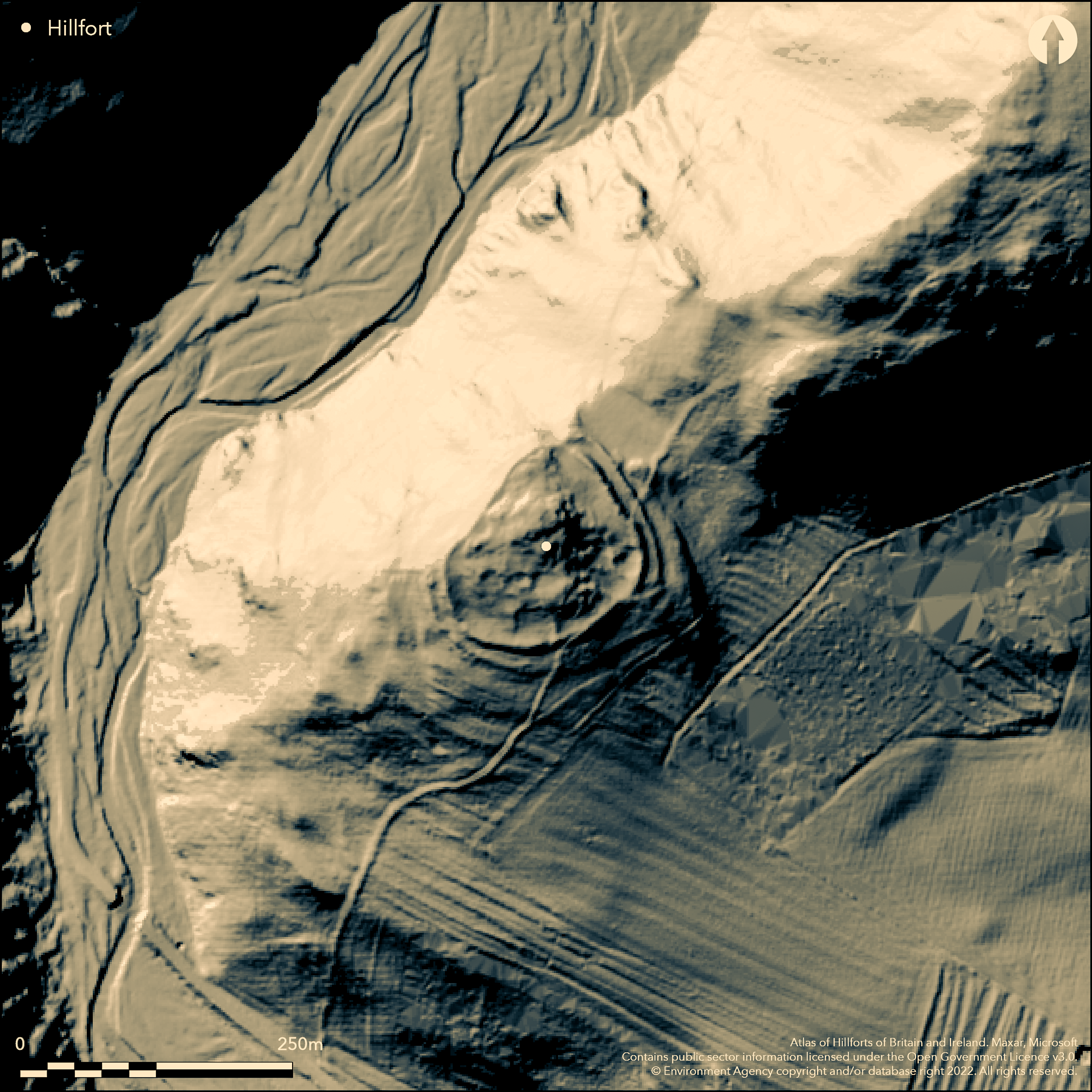
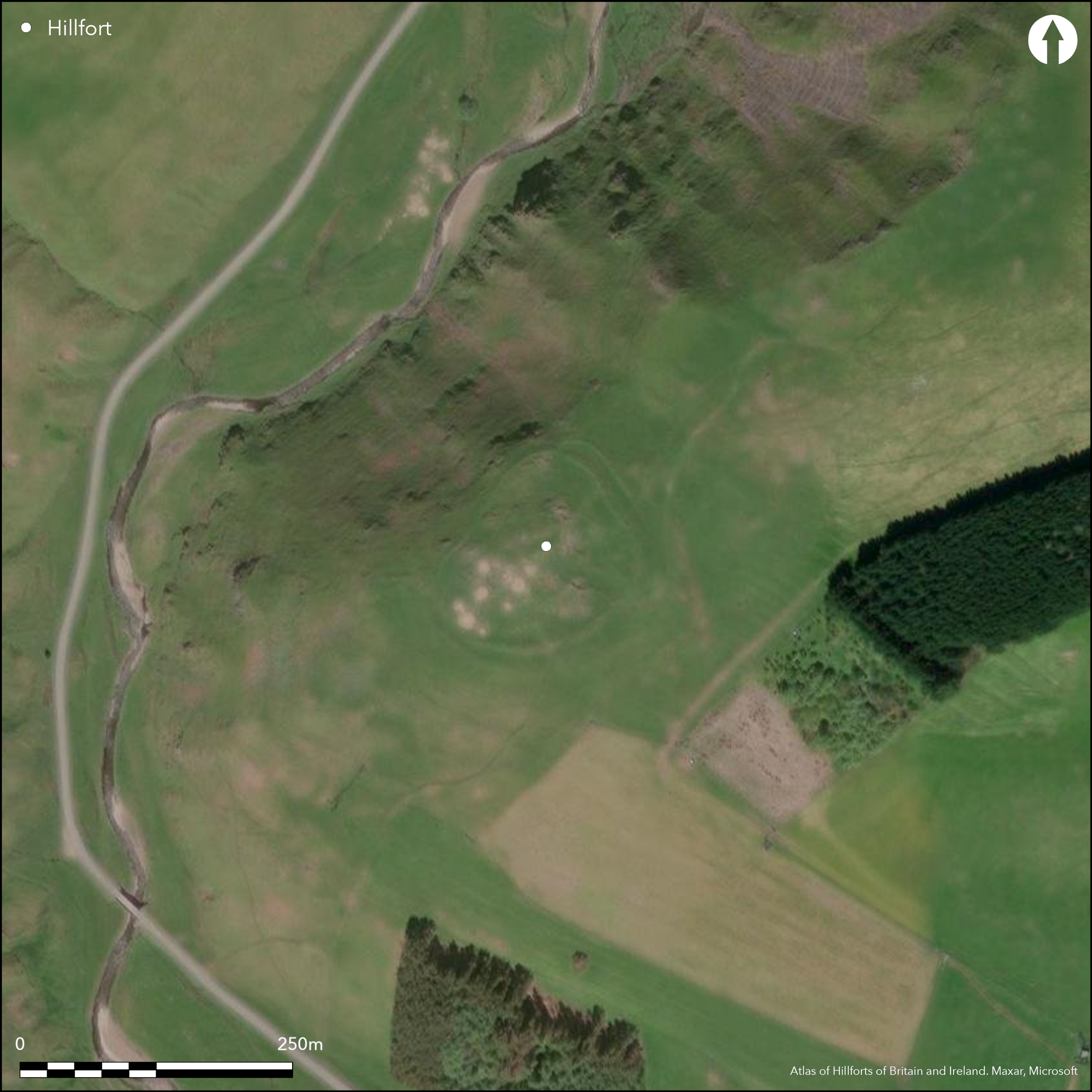
Lying at 259m OD on the SW projecting spur of Clennell Hill overlooking the River Alwin, a univallate hillfort of 0.48ha. A substantial earth and stone rampart follows the natural contours of the spur to form an irregular oval measuring 96m NE-SW by 80m transversely and enclosing 0.48ha. The site is defended in the NW by precipitous slopes and a single rampart 2-3m wide and up to 0.3m high. Elsewhere the rampart measures 4m wide and 1-2 high. A 5m wide berm lies between the rampart and a counterscarp with maximum dimensions of 4m wide by 1m high, which is absent in the NW. No ditches are recorded. Entrances lie in the S and SE and a low bank runs from both entrances to the centre of the site. Towards the centre of the enclosure three circular stone founded houses 7m in diameter have been identified, all with entrances in the SE. A scooped enclosure lies to the N of the entrance, and to the N of the SE entrance, an enclosure with a small circular building 3m in diameter is sited on a mound. All are suggestive of probable Romano-British reuse of the enclosure. The outer rampart has been destroyed in the SE by rig and furrow ploughing and the inner rampart from stone robbing for a field walls, one of which now overlies the ramparts in the SE, but otherwise survives in fair condition. The site is undated and no known excavation has taken place. Recorded on 1856-65 OS mapping. Scheduled
Citizen Science: ✗
Reliability of Data: Confirmed
Reliability of Interpretation: Confirmed
X: -235870 Y: 7432914 (EPSG: 3857)
Longitude: -2.11885219667438 Latitude: 55.36440817709261 (EPSG:4326)
Country: England
Current County or Unitary Authority: Northumberland
Historic County: Northumberland
Current Parish/Community/Council/Townland: Alwinton
None
| Extant | ✓ |
| Cropmark | ✗ |
| Likely Destroyed | ✗ |
None
| Woodland | ✗ |
| Commercial Forestry Plantation | ✗ |
| Parkland | ✗ |
| Pasture (Grazing) | ✓ |
| Arable | ✗ |
| Scrub/Bracken | ✗ |
| Bare Outcrop | ✗ |
| Heather/Moorland | ✗ |
| Heath | ✗ |
| Built-up | ✗ |
| Coastal Grassland | ✗ |
| Other | ✗ |
Univallate contour fort lying at 259m OD on the SW projecting spur of Clennell Hill overlooking the River Alwin.
| Contour Fort | ✗ |
| Partial Contour Fort | ✓ |
| Promontory Fort | ✗ |
| Hillslope Fort | ✗ |
| Level Terrain Fort | ✗ |
| Marsh Fort | ✗ |
| Multiple Enclosure Fort | ✗ |
| Hilltop | ✗ |
| Coastal Promontory | ✗ |
| Inland Promontory | ✗ |
| Valley Bottom | ✗ |
| Knoll/Hillock/Outcrop | ✗ |
| Ridge | ✗ |
| Cliff/Plateau-edge/Scarp | ✗ |
| Hillslope | ✗ |
| Lowland | ✗ |
| Spur | ✓ |
Dominant Topographic Feature: Spur
| North | ✗ |
| Northeast | ✗ |
| East | ✗ |
| Southeast | ✗ |
| South | ✗ |
| Southwest | ✗ |
| West | ✗ |
| Northwest | ✗ |
| Level | ✓ |
Altitude: 259.0m
N/A
Undated, presumed Iron Age
Reliability: D - None
| Pre 1200BC | ✗ |
| 1200BC - 800BC | ✗ |
| 800BC - 400BC | ✗ |
| 400BC - AD50 | ✗ |
| AD50 - AD400 | ✗ |
| AD400 - AD 800 | ✗ |
| Post AD800 | ✗ |
| Unknown | ✓ |
| Pre Hillfort: | None |
| Post Hillfort: | Probable Romano-British re-use |
| Morphology/Earthwork/Typology: | None |
Recorded on 1856-65 OS mapping, general reference in Dodds (1940). Field investigations 1957, 1970, 1976. Scheduled.
| 1st Identified Written Reference (1940): | None |
| Other (1957): | Field investigation |
| Other (1966): | Scheduled |
| Other (1970): | Field investigation |
| Other (1976): | Field investigation |
| 1st Identified Map Depiction (None): | None |
Three circular stone-founded houses 7m in diameter have been identified towards the centre of the enclosure, all with entrances in the SE. A scooped enclosure lies to the N of the entrance, and to the N of the SE entrance an enclosure with a small circular building 3m in diameter is sited on a mound.
None
| None | ✓ |
| Spring | ✗ |
| Stream | ✗ |
| Pool | ✗ |
| Flush | ✗ |
| Well | ✗ |
| Other | ✗ |
Scooped settlement
| No Known Features | ✗ |
| Round Stone Structures | ✓ |
| Rectangular Stone Structures | ✗ |
| Curvilinear Platforms | ✗ |
| Other Roundhouse Evidence | ✗ |
| Pits | ✗ |
| Quarry Hollows | ✗ |
| Other | ✓ |
None
| No Known Excavation | ✓ |
| Pits | ✗ |
| Postholes | ✗ |
| Roundhouses | ✗ |
| Rectangular Structures | ✗ |
| Roads/Tracks | ✗ |
| Quarry Hollows | ✗ |
| Other | ✗ |
| Nothing Found | ✗ |
None
| No Known Geophysics | ✓ |
| Pits | ✗ |
| Roundhouses | ✗ |
| Rectangular Structures | ✗ |
| Roads/Tracks | ✗ |
| Quarry Hollows | ✗ |
| Other | ✗ |
| Nothing Found | ✗ |
None
| No Known Finds | ✓ |
| Pottery | ✗ |
| Metal | ✗ |
| Metalworking | ✗ |
| Human Bones | ✗ |
| Animal Bones | ✗ |
| Lithics | ✗ |
| Environmental | ✗ |
| Other | ✗ |
None
| APs Not Checked | ✓ |
| None | ✗ |
| Roundhouses | ✗ |
| Rectangular Structures | ✗ |
| Pits | ✗ |
| Postholes | ✗ |
| Roads/Tracks | ✗ |
| Other | ✗ |
Simple entrances lie in the S and SE
| 2: | None |
| 2: | None |
Guard Chambers: ✗
Chevaux de Frise: ✗
| 1. Simple Gap (South): | None |
| 2. Simple Gap (South east): | None |
Single rampart in the NW 2-3m wide and 0.3m high. Elsewhere enclosed by a rampart 4m wide and 1-2 high. A 5m wide berm separates the rampart from a 4m wide and 1m high counterscarp. No ditches are recorded.
| Area 1: | 0.48ha. |
| Total: | 0.48ha. |
Total Footprint Area: Noneha.
None
| ✗ | None |
| ✓ | None |
| NE Quadrant: | 1 |
| SE Quadrant: | 1 |
| SW Quadrant: | 1 |
| NW Quadrant: | 1 |
| Total: | 1 |
| Partial Univallate | ✗ |
| Univallate | ✓ |
| Partial Bivallate | ✗ |
| Bivallate | ✗ |
| Partial Multivallate | ✗ |
| Multivallate | ✗ |
| Unknown | ✗ |
| Partial Univallate | ✗ |
| Univallate | ✗ |
| Partial Bivallate | ✗ |
| Bivallate | ✗ |
| Partial Multivallate | ✗ |
| Multivallate | ✗ |
None
| None | ✗ |
| Earthen Bank | ✓ |
| Stone Wall | ✗ |
| Rubble | ✓ |
| Wall-walk | ✗ |
| Evidence of Timber | ✗ |
| Vitrification | ✗ |
| Other Burning | ✗ |
| Palisade | ✗ |
| Counter Scarp Bank | ✓ |
| Berm | ✓ |
| Unfinished | ✗ |
| Other | ✗ |
None
| None | ✗ |
| Earthen Bank | ✗ |
| Stone Wall | ✗ |
| Murus Duplex | ✗ |
| Timber-framed | ✗ |
| Timber-laced | ✗ |
| Vitrification | ✗ |
| Other Burning | ✗ |
| Palisade | ✗ |
| Counter Scarp Bank | ✗ |
| Berm | ✗ |
| Unfinished | ✗ |
| No Known Excavation | ✓ |
| Other | ✗ |
| ✗ | None |
| ✗ | None |
Number of Ditches: None
| ✗ | None |
Dodds, M.H. 1940. A History of Northumberland, Volume 15 (Newcastle upon Tyne), 56.
Hogg, A.H.A. 1979. British Hill-Forts. An Index. British Archaeological Reports, British Series 62; 121
Atlas of Hillforts:
Wikidata:
This work is licensed under CC BY-SA 4.0![]()
![]()
![]() and should be cited as:
and should be cited as:
Lock, Gary and Ralston, Ian. 2024. Atlas of Hillforts of Britain and Ireland. Available at: https://hillforts.arch.ox.ac.uk
Document Version 1.1