LiDAR 1m DTM Hillshade
Satellite Imagery
LiDAR 1m DTM Hillshade
Satellite Imagery
Scroll left/right to view further images.
HER: Northumberland 3605 (None)
NMR: NU 02 SE 7 (5743)
SM: 1006580
NGR: NU 07507 21566
X: 407507 Y: 621566 (OSGB36)
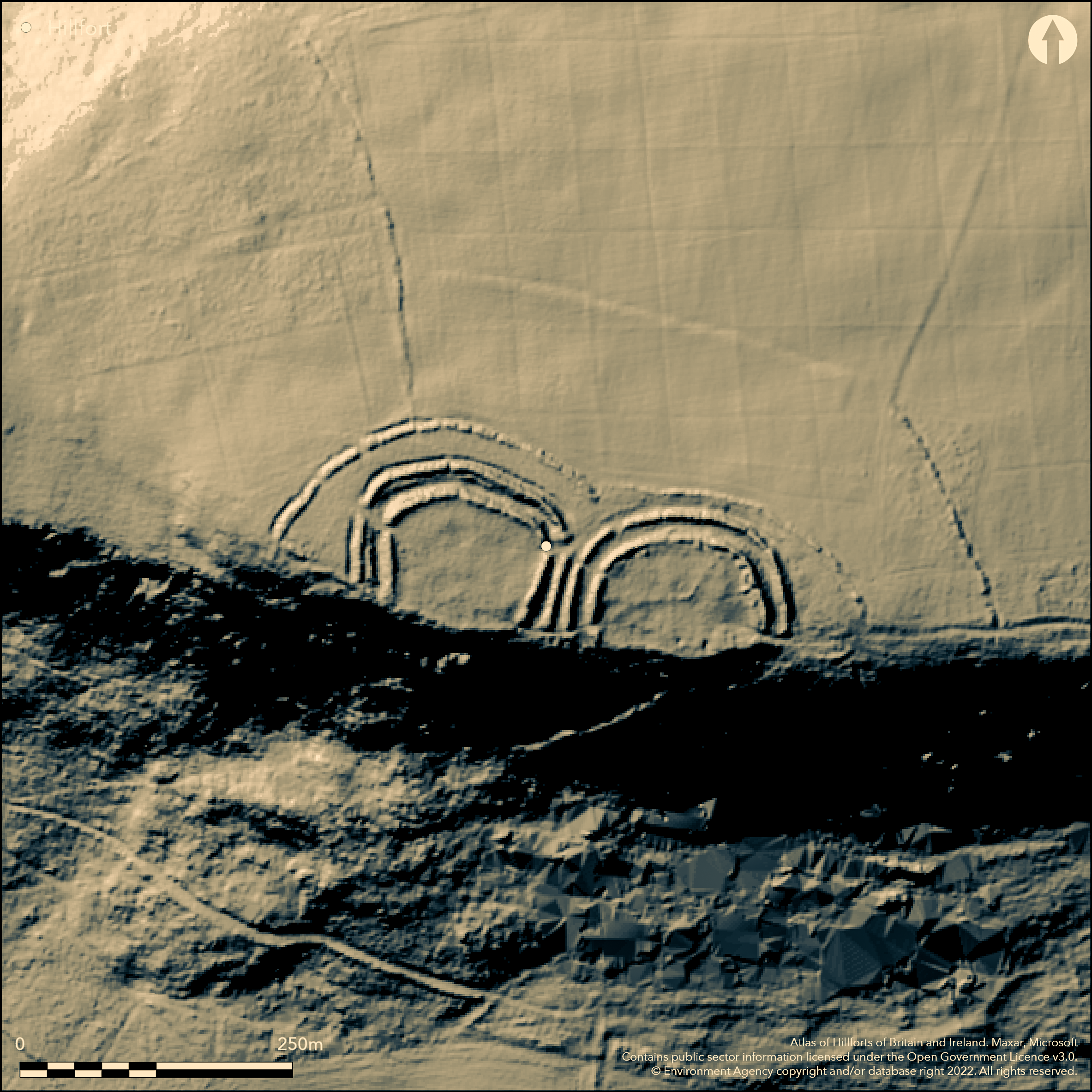
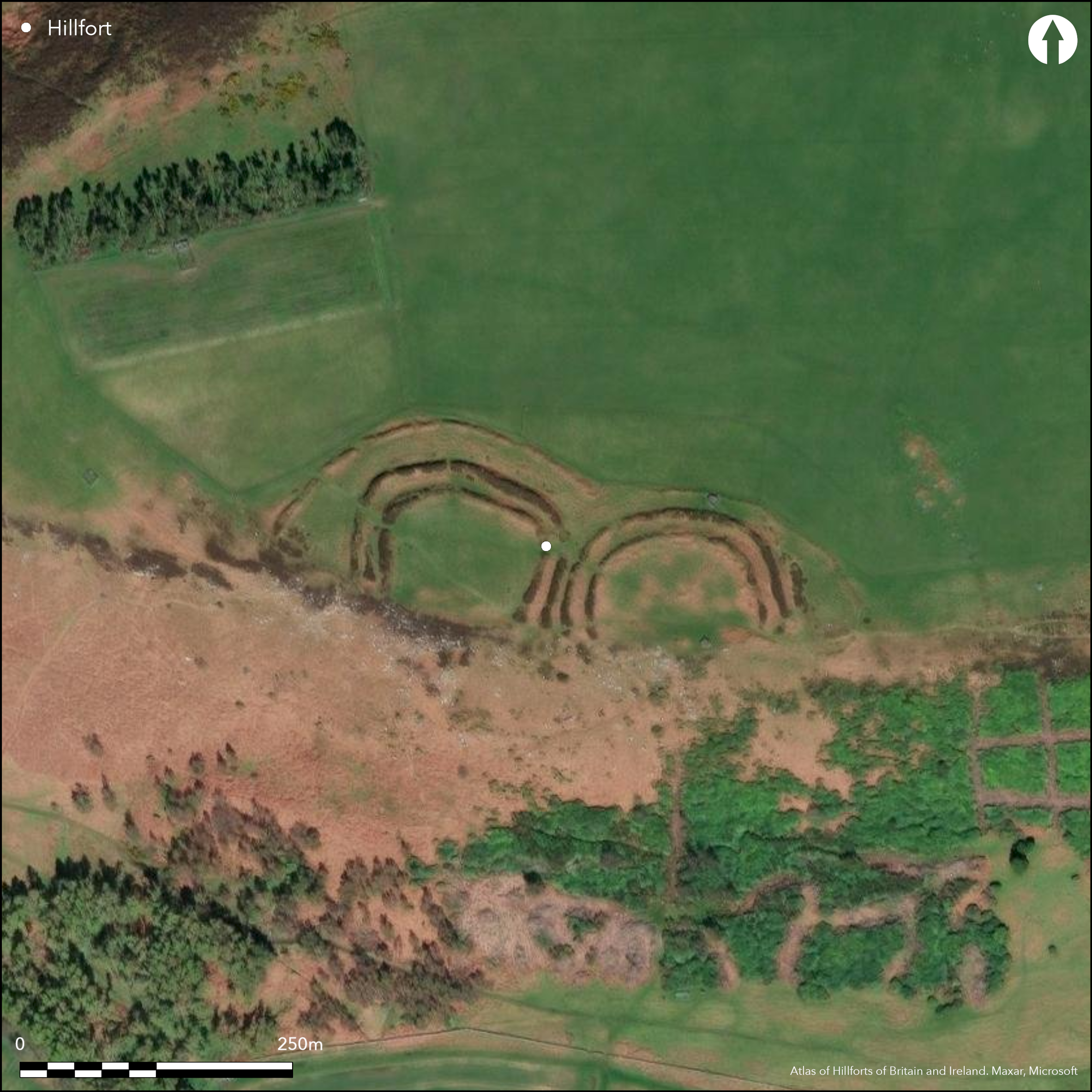
Lying to the E of Hanging Crag on the highest part of Bewick Hill are two adjacent semi-circular multivallate enclosures. They are each bivallate with further rampart encompassing both forts enclosing an area of 0.8ha. This is probably a single site with twin enclosures. It lies on level ground at 220m OD with the S sides open to the precipitous cliff edge. Elsewhere the ground slopes away gently in all directions. The western enclosure has two banks and ditches encompassing 0.39ha. The inner rampart is an earthen bank with a revetment of rough stones. It descends steeply to the rock-cut ditch and continues along the cliff edge. The middle rampart comprises a core of small boulders with soil upcast from ditch. Entrances lie in the NW and NE corners. Two hut circles with a diameter of between 7-17m have been identified within the interior. The enclosure in the E is of a similar size at 0.40ha and also comprises two banks and ditches but is of different construction with the banks formed from large upright stones 3.8m apart with a rubble infill. It has survived less well in the NW corner. It continues as traces of rough walling in the S. An original entrance lies the SE. Three walls lie within the interior and a hut circle lies close to the entrance with a further five lying close to the rampart. A circular rock-cut basin of uncertain purpose has also been recorded. The two inner enclosures are further enclosed by the outer bank which survives between 0.3-1.2m high beyond which is an outer ditch with a maximum depth of 0.6m. In the W there is a 37m wide berm between the outer rampart and that of the the western enclosure. An entrance lies in the SW with a holloway 6m wide and 0.7m deep which is a medieval or post-medieval feature. The site is recorded as 'Camp' on 1856-65 OS mapping. An excavation carried out in 1934 (Charlton 1935) was insufficient to provide any dating. Cup and ring marked stones lie to the E. Scheduled
Citizen Science: ✗
Reliability of Data: Confirmed
Reliability of Interpretation: Confirmed
X: -209587 Y: 7457134 (EPSG: 3857)
Longitude: -1.8827484172490005 Latitude: 55.48787345688855 (EPSG:4326)
Country: England
Current County or Unitary Authority: Northumberland
Historic County: Northumberland
Current Parish/Community/Council/Townland: Bewick
Suffering from localised and limited stock erosion
| Extant | ✓ |
| Cropmark | ✗ |
| Likely Destroyed | ✗ |
Rough pasture and bracken moorland
| Woodland | ✗ |
| Commercial Forestry Plantation | ✗ |
| Parkland | ✗ |
| Pasture (Grazing) | ✓ |
| Arable | ✗ |
| Scrub/Bracken | ✓ |
| Bare Outcrop | ✗ |
| Heather/Moorland | ✓ |
| Heath | ✗ |
| Built-up | ✗ |
| Coastal Grassland | ✗ |
| Other | ✗ |
Twin forts lying at 22m OD with their terminals against a precipitous cliff edge
| Contour Fort | ✓ |
| Partial Contour Fort | ✗ |
| Promontory Fort | ✗ |
| Hillslope Fort | ✗ |
| Level Terrain Fort | ✗ |
| Marsh Fort | ✗ |
| Multiple Enclosure Fort | ✗ |
| Hilltop | ✗ |
| Coastal Promontory | ✗ |
| Inland Promontory | ✓ |
| Valley Bottom | ✗ |
| Knoll/Hillock/Outcrop | ✗ |
| Ridge | ✗ |
| Cliff/Plateau-edge/Scarp | ✓ |
| Hillslope | ✗ |
| Lowland | ✗ |
| Spur | ✗ |
Dominant Topographic Feature: Cliff edge
| North | ✗ |
| Northeast | ✗ |
| East | ✗ |
| Southeast | ✗ |
| South | ✗ |
| Southwest | ✗ |
| West | ✗ |
| Northwest | ✗ |
| Level | ✓ |
Altitude: 220.0m
N/A
Undated, presumed Iron Age based on morphology. Excavation did not provide any dating evidence
Reliability: D - None
| Pre 1200BC | ✗ |
| 1200BC - 800BC | ✗ |
| 800BC - 400BC | ✗ |
| 400BC - AD50 | ✗ |
| AD50 - AD400 | ✗ |
| AD400 - AD 800 | ✗ |
| Post AD800 | ✗ |
| Unknown | ✓ |
| Pre Hillfort: | None |
| Post Hillfort: | Two pillboxes lie within the enclosures |
| Morphology/Earthwork/Typology: | None |
Recorded on 1856-65 OS mapping. The site was excavated in 1934 (Charlton 1935); Field investigations in 1955 and 1969. Scheduled
| Excavation (1934): | None |
| Other (1955): | Field investigation |
| Other (1969): | Field investigation |
| 1st Identified Map Depiction (None): | OS mapping |
| Other (None): | Scheduled |
Two hut circles with a diameter of between 7-17m have been identified within the interior of the western enclosure. In the eastern enclosure three walls lie within the interior and a hut circle lies close to the entrance, with a further five lying close to the rampart.
Springs and a streams lie in the E, S and W.
| None | ✓ |
| Spring | ✗ |
| Stream | ✗ |
| Pool | ✗ |
| Flush | ✗ |
| Well | ✗ |
| Other | ✗ |
Hut circles
| No Known Features | ✗ |
| Round Stone Structures | ✓ |
| Rectangular Stone Structures | ✗ |
| Curvilinear Platforms | ✗ |
| Other Roundhouse Evidence | ✗ |
| Pits | ✗ |
| Quarry Hollows | ✗ |
| Other | ✗ |
None
| No Known Excavation | ✗ |
| Pits | ✗ |
| Postholes | ✗ |
| Roundhouses | ✗ |
| Rectangular Structures | ✗ |
| Roads/Tracks | ✗ |
| Quarry Hollows | ✗ |
| Other | ✗ |
| Nothing Found | ✓ |
None
| No Known Geophysics | ✓ |
| Pits | ✗ |
| Roundhouses | ✗ |
| Rectangular Structures | ✗ |
| Roads/Tracks | ✗ |
| Quarry Hollows | ✗ |
| Other | ✗ |
| Nothing Found | ✗ |
None
| No Known Finds | ✓ |
| Pottery | ✗ |
| Metal | ✗ |
| Metalworking | ✗ |
| Human Bones | ✗ |
| Animal Bones | ✗ |
| Lithics | ✗ |
| Environmental | ✗ |
| Other | ✗ |
None
| APs Not Checked | ✓ |
| None | ✗ |
| Roundhouses | ✗ |
| Rectangular Structures | ✗ |
| Pits | ✗ |
| Postholes | ✗ |
| Roads/Tracks | ✗ |
| Other | ✗ |
Western enclosure - entrances lie in the NW and NE corners through both enclosure banks. Eastern enclosure - a single entrance lies in the SE through both enclosure banks. Within the enclosing bank an entrance lies in the SW.
| 7: | None |
| 2: | None |
Guard Chambers: ✗
Chevaux de Frise: ✗
| 1. Simple Gap (North west): | Western enclosure inner |
| 2. Simple Gap (North west): | Western enclosure outer |
| 3. Simple Gap (North east): | Western enclosure inner |
| 4. Simple Gap (North east): | Western enclosure outer |
| 5. Simple Gap (South east): | Eastern enclosure inner |
| 6. Simple Gap (South east): | Eastern enclosure outer |
| 7. Simple Gap (South west): | Outer enclosure |
Western enclosure - Two banks and ditches encloses an area of 0.39ha. The inner rampart is an earthen bank with a revetment of rough stones. It descends steeply to the rock-cut ditch and continues along the cliff edge. The middle rampart comprises a core of small boulders with soil upcast from ditch. Eastern ditch comprises two banks and ditches but of different construction with the banks formed from upright stones 3.8m apart with a rubble infill. It has survived less well in the NW corner. It continues as traces of rough walling in the S. The hillforts are enclosed by a further bank surviving between 0.3-1.2m high with an outer ditch with a maximum depth of 0.6m.
| Area 1: | 0.39ha. |
| Area 2: | 0.4ha. |
| Total: | 0.4ha. |
Total Footprint Area: 0.8ha.
None
| ✗ | Western enclosure 0.39ha, eastern enclosure 0.4ha |
| ✗ | Slighter banks run partially along the cliff edge in the S |
| NE Quadrant: | 3 |
| SE Quadrant: | 1 |
| SW Quadrant: | 1 |
| NW Quadrant: | 3 |
| Total: | 3 |
| Partial Univallate | ✓ |
| Univallate | ✗ |
| Partial Bivallate | ✗ |
| Bivallate | ✗ |
| Partial Multivallate | ✓ |
| Multivallate | ✗ |
| Unknown | ✗ |
| Partial Univallate | ✗ |
| Univallate | ✗ |
| Partial Bivallate | ✗ |
| Bivallate | ✗ |
| Partial Multivallate | ✗ |
| Multivallate | ✗ |
None
| None | ✗ |
| Earthen Bank | ✓ |
| Stone Wall | ✓ |
| Rubble | ✓ |
| Wall-walk | ✗ |
| Evidence of Timber | ✗ |
| Vitrification | ✗ |
| Other Burning | ✗ |
| Palisade | ✗ |
| Counter Scarp Bank | ✗ |
| Berm | ✗ |
| Unfinished | ✗ |
| Other | ✗ |
None
| None | ✓ |
| Earthen Bank | ✗ |
| Stone Wall | ✗ |
| Murus Duplex | ✗ |
| Timber-framed | ✗ |
| Timber-laced | ✗ |
| Vitrification | ✗ |
| Other Burning | ✗ |
| Palisade | ✗ |
| Counter Scarp Bank | ✗ |
| Berm | ✗ |
| Unfinished | ✗ |
| No Known Excavation | ✗ |
| Other | ✗ |
| ✗ | None |
| ✓ | Described as two ditches for each enclosure and a further ditch associated with the outer enclosure |
Number of Ditches: 5
| ✗ | None |
Charlton J. 1935. Report on a trial excavation at Old Bewick. Proc Soc Antiq Newcastle. Series 4, 6, 252-6
Gates, T. and Deegan, A. 2009. Monuments in the Landscape in Passmore, D.G. and Waddington, C. (eds). Managing Archaeological Landscapes in Northumberland. Till-Tweed Studies, Vol 1. Oxbow, 125-71.
Jobey, G .1965. Hillforts and Settlements in Northumberland. Archaeol Aeliana (4th Series)
Atlas of Hillforts:
Wikidata:
This work is licensed under CC BY-SA 4.0![]()
![]()
![]() and should be cited as:
and should be cited as:
Lock, Gary and Ralston, Ian. 2024. Atlas of Hillforts of Britain and Ireland. Available at: https://hillforts.arch.ox.ac.uk
Document Version 1.1