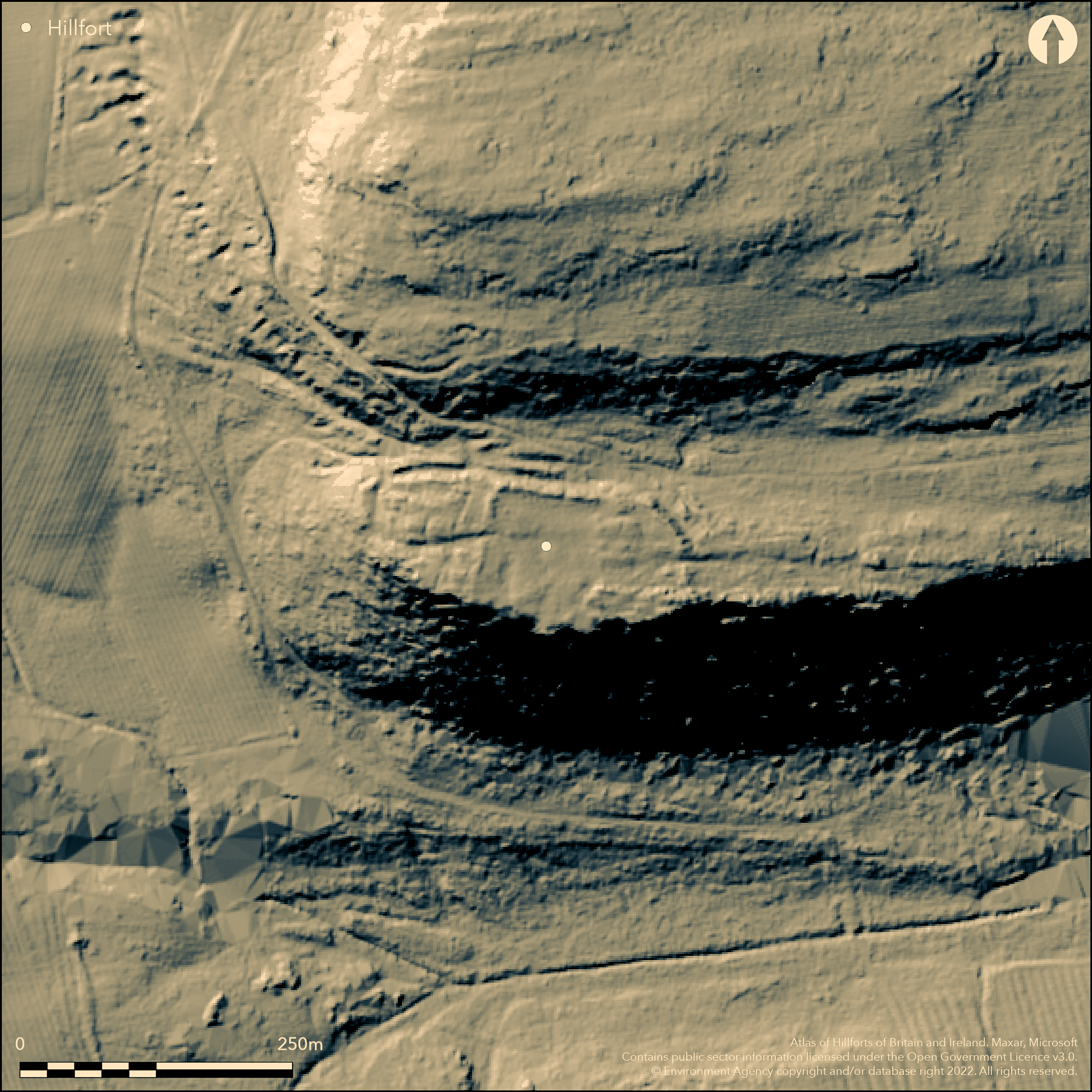
LiDAR 1m DTM Hillshade

Satellite Imagery
LiDAR 1m DTM Hillshade
Satellite Imagery
Scroll left/right to view further images.
HER: Northumberland 10566 (None)
NMR: NZ 08 SE 1 (21017)
SM: 1011835
NGR: NZ 0515 8170
X: 405150 Y: 581700 (OSGB36)
Lying at 186m OD on a ledge below the highest point on Shaftoe Crags, a multivallate enclosure described variously as a hillfort or promontory fort but scheduled as a defended enclosure. The enclosure measures 166m E-W by 70m transversely enclosing approximately 0.9ha. It lies in a dominant position on the edge of Shaftoe Crags, now a venue for boulderers owing to the difficulty in scaling the southern escarpment. It has extensive views across relatively level ground in the S and SW, the enclosure on the N and NE defended by three earth and stone ramparts 7-8m wide and 0.6-2.5m high. The ramparts are thought to have once extended around the eastern side. No ditch. a simple gap entrance lies in the E with a possible later entrance in the NW. The hillfort is unequally divided by a wall of large upright stones with the larger area lying in the E. The site is recorded on 1856-65 OS mapping, but is undated and presumed Iron Age. A survey was carried out in 1986 (Sellars et al.). A magnetometry and resistance survey Mitchum (1993) did not record any features.
Citizen Science: ✗
Reliability of Data: Confirmed
Reliability of Interpretation: Confirmed
X: -213819 Y: 7387074 (EPSG: 3857)
Longitude: -1.920765594383406 Latitude: 55.12967263091311 (EPSG:4326)
Country: England
Current County or Unitary Authority: Northumberland
Historic County: Northumberland
Current Parish/Community/Council/Townland: Capheaton
None
| Extant | ✓ |
| Cropmark | ✗ |
| Likely Destroyed | ✗ |
Rough grassland; solid geology - Millstone Grit
| Woodland | ✗ |
| Commercial Forestry Plantation | ✗ |
| Parkland | ✗ |
| Pasture (Grazing) | ✓ |
| Arable | ✗ |
| Scrub/Bracken | ✗ |
| Bare Outcrop | ✗ |
| Heather/Moorland | ✗ |
| Heath | ✗ |
| Built-up | ✗ |
| Coastal Grassland | ✗ |
| Other | ✗ |
Lying at 186m OD on a rocky shelf below the highest point on Shaftoe Crags, a probable hillfort, sometimes described as a promontory fort. It lies on the southern edge of steep scarp by which is is naturally defended. The location offers extensive views to the S, SE and SW.
| Contour Fort | ✓ |
| Partial Contour Fort | ✗ |
| Promontory Fort | ✓ |
| Hillslope Fort | ✗ |
| Level Terrain Fort | ✓ |
| Marsh Fort | ✗ |
| Multiple Enclosure Fort | ✗ |
| Hilltop | ✗ |
| Coastal Promontory | ✗ |
| Inland Promontory | ✓ |
| Valley Bottom | ✗ |
| Knoll/Hillock/Outcrop | ✗ |
| Ridge | ✗ |
| Cliff/Plateau-edge/Scarp | ✓ |
| Hillslope | ✗ |
| Lowland | ✗ |
| Spur | ✗ |
Dominant Topographic Feature: Rocky shelf below Shaftoe Crags
| North | ✗ |
| Northeast | ✗ |
| East | ✗ |
| Southeast | ✓ |
| South | ✓ |
| Southwest | ✓ |
| West | ✗ |
| Northwest | ✗ |
| Level | ✗ |
Altitude: 186.0m
N/A
Undated, presumed Iron Age
Reliability: D - None
| Pre 1200BC | ✗ |
| 1200BC - 800BC | ✗ |
| 800BC - 400BC | ✗ |
| 400BC - AD50 | ✗ |
| AD50 - AD400 | ✗ |
| AD400 - AD 800 | ✗ |
| Post AD800 | ✗ |
| Unknown | ✓ |
| Pre Hillfort: | Cup and ring marked stones lie in the vicinity |
| Post Hillfort: | None |
| Morphology/Earthwork/Typology: | None |
The site appears on 1856-65 OS mapping. General reference in Ball (1921-2). Field investigation 1968. It was surveyed in 1986 (Sellars et al. 1986); Geophysical survey 1993. Scheduled
| Other (1963): | Scheduled |
| Other (1968): | Field investigation |
| Earthwork Survey (1986): | None |
| Geophysical Survey (1993): | AML. |
| Other (1993): | University of Nottingham dissertation |
| 1st Identified Map Depiction (None): | None |
| 1st Identified Written Reference (None): | Ball, T., 1921-2. Proceedings of the Society of Antiquaries of Newcastle (3rd Series) 10, 242-4. |
A wall of large upright stones divides the enclosure N-S with the larger area lying in the E.
None
| None | ✓ |
| Spring | ✗ |
| Stream | ✗ |
| Pool | ✗ |
| Flush | ✗ |
| Well | ✗ |
| Other | ✗ |
Wall of large upright stones
| No Known Features | ✗ |
| Round Stone Structures | ✗ |
| Rectangular Stone Structures | ✗ |
| Curvilinear Platforms | ✗ |
| Other Roundhouse Evidence | ✗ |
| Pits | ✗ |
| Quarry Hollows | ✗ |
| Other | ✓ |
None
| No Known Excavation | ✓ |
| Pits | ✗ |
| Postholes | ✗ |
| Roundhouses | ✗ |
| Rectangular Structures | ✗ |
| Roads/Tracks | ✗ |
| Quarry Hollows | ✗ |
| Other | ✗ |
| Nothing Found | ✗ |
None
| No Known Geophysics | ✗ |
| Pits | ✗ |
| Roundhouses | ✗ |
| Rectangular Structures | ✗ |
| Roads/Tracks | ✗ |
| Quarry Hollows | ✗ |
| Other | ✗ |
| Nothing Found | ✓ |
None
| No Known Finds | ✓ |
| Pottery | ✗ |
| Metal | ✗ |
| Metalworking | ✗ |
| Human Bones | ✗ |
| Animal Bones | ✗ |
| Lithics | ✗ |
| Environmental | ✗ |
| Other | ✗ |
None
| APs Not Checked | ✓ |
| None | ✗ |
| Roundhouses | ✗ |
| Rectangular Structures | ✗ |
| Pits | ✗ |
| Postholes | ✗ |
| Roads/Tracks | ✗ |
| Other | ✗ |
Entrance lies in the E with a possible later entrance in the NW.
| 2: | None |
| 2: | None |
Guard Chambers: ✗
Chevaux de Frise: ✗
| 1. Simple Gap (East): | None |
| 2. Simple Gap (North west): | Possibly not contemporary with the construction of the hillfort |
The enclosure measures 166m E-W by 70m transversely, enclosing approximately 0.9ha. Naturally defended in the S and SW by precipitous cliffs, the enclosure is defended in the N and NE by three earth and stone ramparts 7-8m wide and 0.6-2.5m high. The ramparts are thought to have once extended around the eastern side. No ditch.
| Area 1: | 0.9ha. |
| Total: | 0.9ha. |
Total Footprint Area: Noneha.
None
| ✗ | None |
| ✗ | N and NE |
| NE Quadrant: | 3 |
| SE Quadrant: | None |
| SW Quadrant: | None |
| NW Quadrant: | 3 |
| Total: | 3 |
| Partial Univallate | ✗ |
| Univallate | ✗ |
| Partial Bivallate | ✗ |
| Bivallate | ✗ |
| Partial Multivallate | ✓ |
| Multivallate | ✗ |
| Unknown | ✗ |
| Partial Univallate | ✗ |
| Univallate | ✗ |
| Partial Bivallate | ✗ |
| Bivallate | ✗ |
| Partial Multivallate | ✗ |
| Multivallate | ✗ |
None
| None | ✗ |
| Earthen Bank | ✓ |
| Stone Wall | ✗ |
| Rubble | ✓ |
| Wall-walk | ✗ |
| Evidence of Timber | ✗ |
| Vitrification | ✗ |
| Other Burning | ✗ |
| Palisade | ✗ |
| Counter Scarp Bank | ✗ |
| Berm | ✗ |
| Unfinished | ✗ |
| Other | ✗ |
None
| None | ✗ |
| Earthen Bank | ✗ |
| Stone Wall | ✗ |
| Murus Duplex | ✗ |
| Timber-framed | ✗ |
| Timber-laced | ✗ |
| Vitrification | ✗ |
| Other Burning | ✗ |
| Palisade | ✗ |
| Counter Scarp Bank | ✗ |
| Berm | ✗ |
| Unfinished | ✗ |
| No Known Excavation | ✓ |
| Other | ✗ |
| ✗ | None |
| ✗ | None |
Number of Ditches: 0
| ✗ | None |
Ball, T. 1921-2. Proc Soc Antiq Newcastle (3rd Series) 10, 242-4.
Mitcham, J. L. 1993. An Investigation and Survey of Shaftoe Crags Hillfort, Northumberland. Unpublished Thesis, University of Nottingham, Department of Archaeology
Sellers, P. Butcher B., Maddison, M. and Brown, S 1986 Shaftoe Crags hillfort, Northumberland [trivallate promontory-type, surveyed]. Northern Archaeol 7(2), 1986 43-5
Atlas of Hillforts:
Wikidata:
This work is licensed under CC BY-SA 4.0![]()
![]()
![]() and should be cited as:
and should be cited as:
Lock, Gary and Ralston, Ian. 2024. Atlas of Hillforts of Britain and Ireland. Available at: https://hillforts.arch.ox.ac.uk
Document Version 1.1