LiDAR 1m DTM Hillshade
Satellite Imagery
LiDAR 1m DTM Hillshade
Satellite Imagery
Scroll left/right to view further images.
HER: Northumberland 4380 (None)
NMR: NU 11 NW 21 (7033)
SM: 1008839
NGR: NU 1190 1514
X: 411901 Y: 615140 (OSGB36)
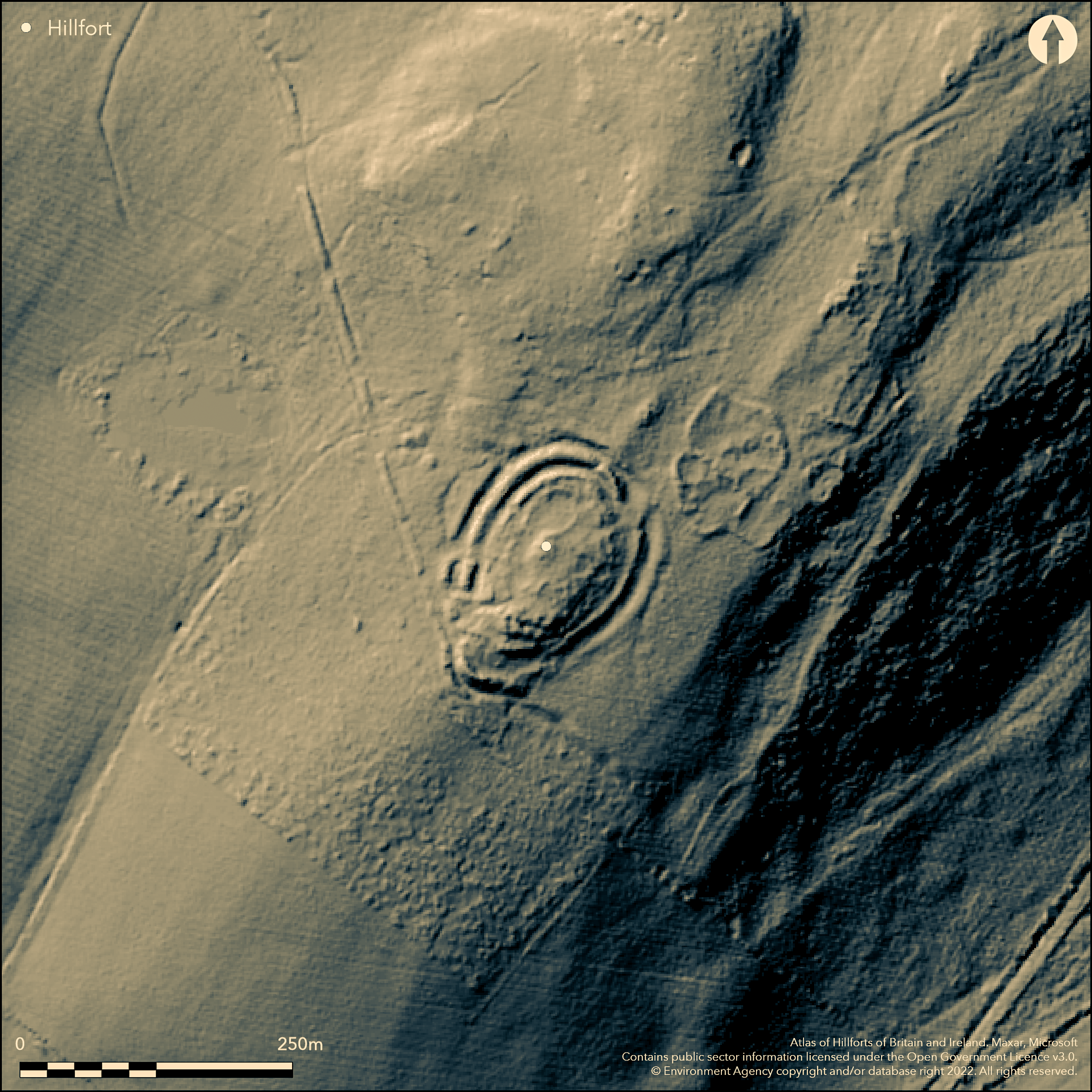
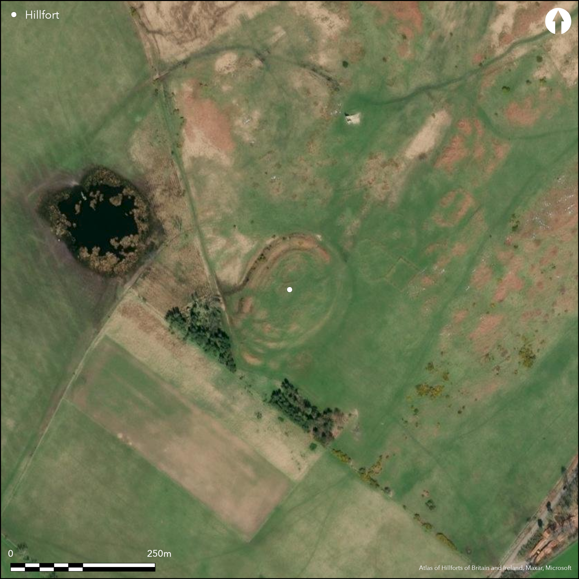
A multivallate hillfort lying at 135m OD to the SW of East Bolton. The hillfort is approximately oval in plan 100 NE-SW by 68m transversely and comprises two earth and stone ramparts, two intermediate ditches and a counterscarp bank. It is situated on a spur of a south-facing hill just below the brow of the hill. The ramparts are 5m wide, the inner rampart between 0.3-0.6m high and the outer rampart up to 1.5m high in the NW. The ditches are 6m wide. Entrances lie in the NE and SW corners. Transverse banks delineate a passageway through the SW entrance. The remains of a number of stone-founded circular houses 4-6m in diameter, within fragments of stone walling up to 0.2m high, partially divides the interior into three or four compartments. This most probably represents secondary, Romano-British occupation of the hillfort. The enclosing works are considerably damaged in the SE. A lachrymatory (tear bottle) was discovered on the surface in October 1824 and a small excavation c.1885 produced a quernstone and a stone handmill (Hardy 1885). The location of the finds is unknown. The site survives in good to reasonable condition but is mostly destroyed in the SE. An extensive Romano-British settlement and field system lies on the brow of the hill a few metres to the E. The site is recorded on 1856-65 OS mapping. Undated.
Citizen Science: ✗
Reliability of Data: Confirmed
Reliability of Interpretation: Confirmed
X: -201876 Y: 7445781 (EPSG: 3857)
Longitude: -1.8134857387633563 Latitude: 55.43004558807417 (EPSG:4326)
Country: England
Current County or Unitary Authority: Northumberland
Historic County: Northumberland
Current Parish/Community/Council/Townland: Hedgeley
Very damaged in the SE
| Extant | ✓ |
| Cropmark | ✗ |
| Likely Destroyed | ✗ |
Rough grazing and bracken
| Woodland | ✗ |
| Commercial Forestry Plantation | ✗ |
| Parkland | ✗ |
| Pasture (Grazing) | ✓ |
| Arable | ✗ |
| Scrub/Bracken | ✓ |
| Bare Outcrop | ✗ |
| Heather/Moorland | ✗ |
| Heath | ✗ |
| Built-up | ✗ |
| Coastal Grassland | ✗ |
| Other | ✗ |
A partial contour fort lying on a spur at 135m OD
| Contour Fort | ✗ |
| Partial Contour Fort | ✓ |
| Promontory Fort | ✗ |
| Hillslope Fort | ✗ |
| Level Terrain Fort | ✗ |
| Marsh Fort | ✗ |
| Multiple Enclosure Fort | ✗ |
| Hilltop | ✗ |
| Coastal Promontory | ✗ |
| Inland Promontory | ✗ |
| Valley Bottom | ✗ |
| Knoll/Hillock/Outcrop | ✗ |
| Ridge | ✗ |
| Cliff/Plateau-edge/Scarp | ✗ |
| Hillslope | ✗ |
| Lowland | ✗ |
| Spur | ✓ |
Dominant Topographic Feature: Below the brow of a hill on a small spur
| North | ✗ |
| Northeast | ✗ |
| East | ✗ |
| Southeast | ✓ |
| South | ✓ |
| Southwest | ✓ |
| West | ✗ |
| Northwest | ✗ |
| Level | ✗ |
Altitude: 135.0m
N/A
Undated, presumed Iron Age
Reliability: D - None
| Pre 1200BC | ✗ |
| 1200BC - 800BC | ✗ |
| 800BC - 400BC | ✗ |
| 400BC - AD50 | ✗ |
| AD50 - AD400 | ✗ |
| AD400 - AD 800 | ✗ |
| Post AD800 | ✗ |
| Unknown | ✓ |
| Pre Hillfort: | None |
| Post Hillfort: | Romano-British settlement |
| Morphology/Earthwork/Typology: | None |
General reference in MacLauchlan (1864). The site is recorded on 1856-65 OS mapping. Reference to a 'recent' excavation by members of the Berwickshire Naturalists Club by Hardy (1885). Field investigations 1956 and 1970. Scheduled
| 1st Identified Written Reference (1864): | None |
| Excavation (1885): | (Hardy 1885) |
| Other (1956): | Field investigation |
| Other (1970): | Field investigation |
| Other (1994): | Scheduled |
| 1st Identified Map Depiction (None): | None |
A number of stone-founded circular huts 4-6m in diameter lie within fragments of stone walling up to 0.2m high which partially divides the interior into three or four compartments. Most probably secondary occupation. A lachrymatory (tear bottle) was discovered on the surface in October 1824 and a small excavation c.1885 produced a quernstone and a stone handmill (Hardy 1885).
None
| None | ✓ |
| Spring | ✗ |
| Stream | ✗ |
| Pool | ✗ |
| Flush | ✗ |
| Well | ✗ |
| Other | ✗ |
None
| No Known Features | ✗ |
| Round Stone Structures | ✓ |
| Rectangular Stone Structures | ✗ |
| Curvilinear Platforms | ✗ |
| Other Roundhouse Evidence | ✗ |
| Pits | ✗ |
| Quarry Hollows | ✗ |
| Other | ✗ |
No features recorded
| No Known Excavation | ✗ |
| Pits | ✗ |
| Postholes | ✗ |
| Roundhouses | ✗ |
| Rectangular Structures | ✗ |
| Roads/Tracks | ✗ |
| Quarry Hollows | ✗ |
| Other | ✗ |
| Nothing Found | ✓ |
None
| No Known Geophysics | ✓ |
| Pits | ✗ |
| Roundhouses | ✗ |
| Rectangular Structures | ✗ |
| Roads/Tracks | ✗ |
| Quarry Hollows | ✗ |
| Other | ✗ |
| Nothing Found | ✗ |
Quernstone and stone handmill
| No Known Finds | ✗ |
| Pottery | ✗ |
| Metal | ✗ |
| Metalworking | ✗ |
| Human Bones | ✗ |
| Animal Bones | ✗ |
| Lithics | ✗ |
| Environmental | ✗ |
| Other | ✓ |
None
| APs Not Checked | ✓ |
| None | ✗ |
| Roundhouses | ✗ |
| Rectangular Structures | ✗ |
| Pits | ✗ |
| Postholes | ✗ |
| Roads/Tracks | ✗ |
| Other | ✗ |
Entrances lie in the NE and SW corners. Transverse banks delineate a passageway through the SW entrance.
| 4: | None |
| 2: | None |
Guard Chambers: ✗
Chevaux de Frise: ✗
| 1. Simple Gap (North east): | inner rampart |
| 1. Simple Gap (North east): | Outer rampart |
| 2. Passage-way/Corridor (South west): | Inner rampart; transverse banks |
| 2. Passage-way/Corridor (South west): | Outer rampart; transverse banks |
Oval in plan 100 NE-SW by 68m transversely. It comprises two earth and stone ramparts, two intermediate ditches and a counterscarp bank. The ramparts are 5m wide, the inner rampart between 0.3-0.6m high and the outer rampart up to 1.5m high in the NW. The ditches are 6m wide.
| Area 1: | 0.28ha. |
| Total: | 0.28ha. |
Total Footprint Area: 1.1ha.
None
| ✗ | None |
| ✓ | None |
| NE Quadrant: | 2 |
| SE Quadrant: | 2 |
| SW Quadrant: | 2 |
| NW Quadrant: | 2 |
| Total: | 2 |
| Partial Univallate | ✗ |
| Univallate | ✗ |
| Partial Bivallate | ✗ |
| Bivallate | ✓ |
| Partial Multivallate | ✗ |
| Multivallate | ✗ |
| Unknown | ✗ |
| Partial Univallate | ✗ |
| Univallate | ✗ |
| Partial Bivallate | ✗ |
| Bivallate | ✗ |
| Partial Multivallate | ✗ |
| Multivallate | ✗ |
None
| None | ✗ |
| Earthen Bank | ✓ |
| Stone Wall | ✗ |
| Rubble | ✓ |
| Wall-walk | ✗ |
| Evidence of Timber | ✗ |
| Vitrification | ✗ |
| Other Burning | ✗ |
| Palisade | ✗ |
| Counter Scarp Bank | ✓ |
| Berm | ✗ |
| Unfinished | ✗ |
| Other | ✗ |
Interior only investigated
| None | ✗ |
| Earthen Bank | ✗ |
| Stone Wall | ✗ |
| Murus Duplex | ✗ |
| Timber-framed | ✗ |
| Timber-laced | ✗ |
| Vitrification | ✗ |
| Other Burning | ✗ |
| Palisade | ✗ |
| Counter Scarp Bank | ✗ |
| Berm | ✗ |
| Unfinished | ✗ |
| No Known Excavation | ✗ |
| Other | ✓ |
| ✗ | None |
| ✓ | None |
Number of Ditches: 2
| ✗ | None |
Hardy, J.1885 On Urns and Antiquities of the Cheviot Hills. Hist Berwickshire Natur Club part 1, 310-11
Jobey, G.1965. Hillforts and Settlements in Northumberland. Archaeol Aeliana (4th Series) 43, 61 No 51
Atlas of Hillforts:
Wikidata:
This work is licensed under CC BY-SA 4.0![]()
![]()
![]() and should be cited as:
and should be cited as:
Lock, Gary and Ralston, Ian. 2024. Atlas of Hillforts of Britain and Ireland. Available at: https://hillforts.arch.ox.ac.uk
Document Version 1.1