LiDAR 1m DTM Hillshade
Satellite Imagery
LiDAR 1m DTM Hillshade
Satellite Imagery
Scroll left/right to view further images.
HER: Northumberland 1282 (None)
NMR: NT 91 NE 29 (1033854)
SM: 1021382
NGR: NT 9985 1636
X: 399852 Y: 616363 (OSGB36)
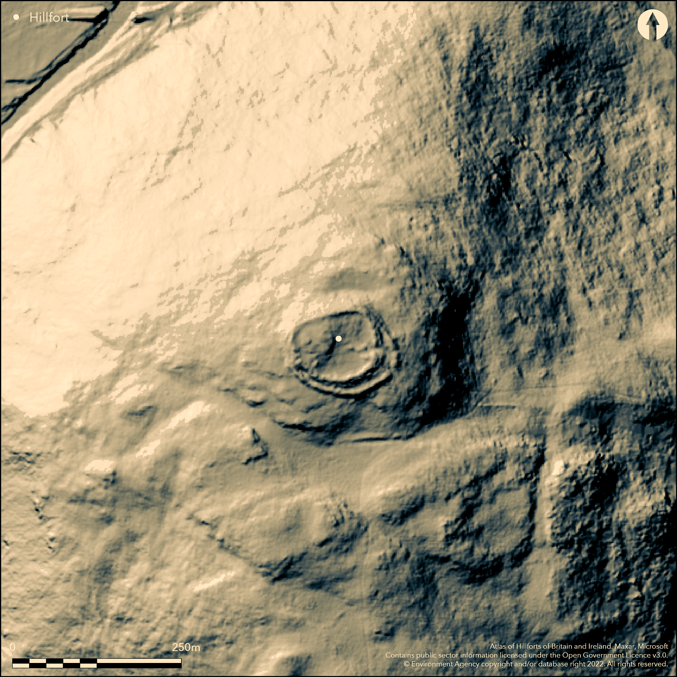
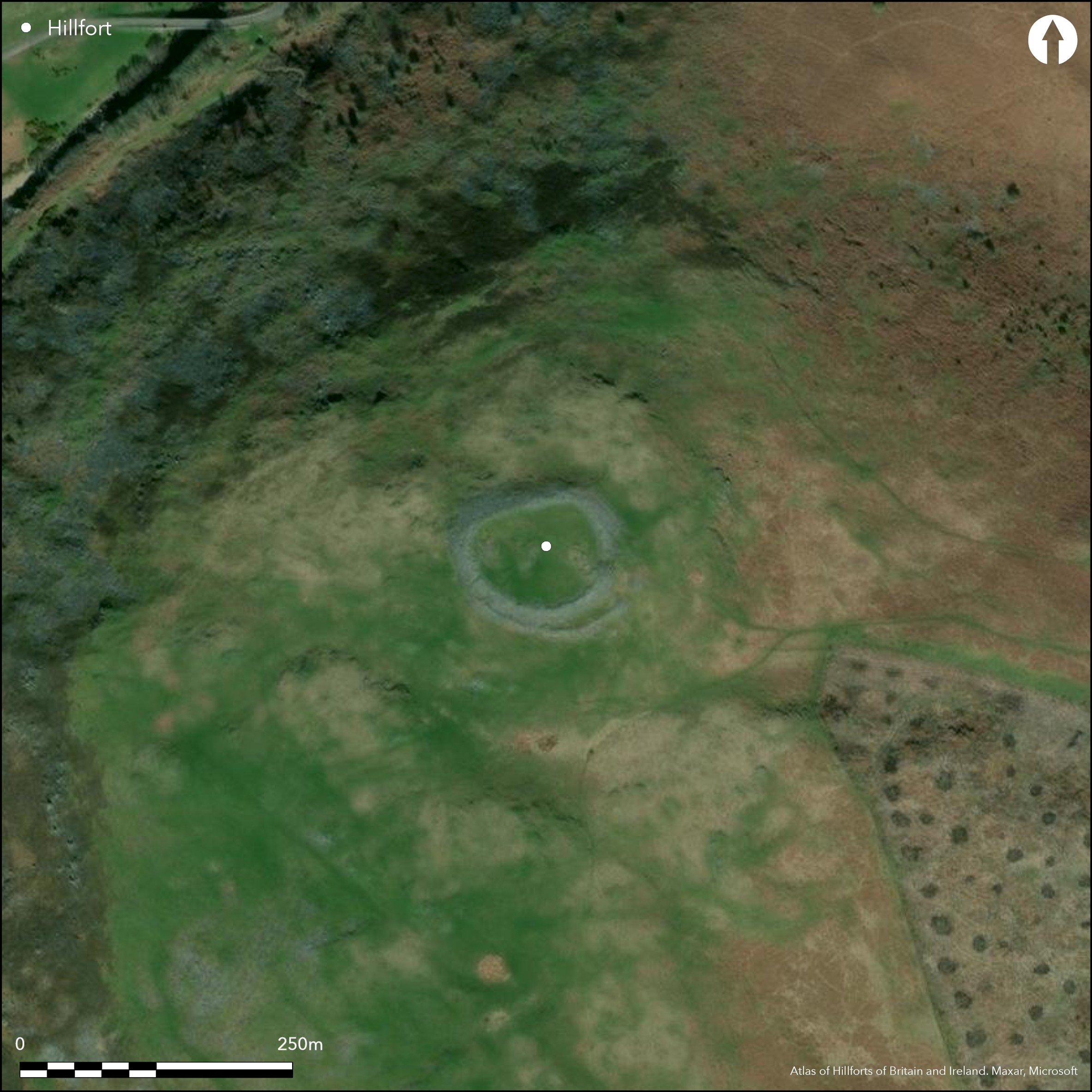
Lying at 290m on the summit of Brough Law and overlooking a bend in the River Breamish, an imposing sub-circular multivallate Iron Age hillfort measuring 68m E-W by 54m transversely, enclosing 0.32ha. The construction of the rampart is similar to that at Greaves Ash hillfort (Atlas No. 2029) 3.7km to the W and comprises three sets of defences; a massive stone rampart with a further stone retaining wall which joins the outer side of the enclosing rampart in the N and S and curves to form an arc which meets in the E. The inner rampart has a double outer face comprising loose unhewn stone retained by a wall of large rectangular stone blocks surviving up to six courses high and 3.5m wide in the N, widening to 5.5m wide at the entrance. The outer semi-circular enclosure, constructed of loose stone is now extensively robbed surviving as a 2m wide rubble bank with a maximum height of 5m. Stone walls run between the two ramparts dividing the space into compartments. The original entrances through the two ramparts are staggered with a cut through the inner enclosure wall in the E, 3.8m wide on the inner face and 2.6m wide on the outer and with the entrance in the outer rampart lying further to the SE. Damage to the outer rampart prevents accurate measurement of the entrance but it is estimated at 2.5m wide. A probable later break in the W connects to a path leading down to the valley bottom. Further breaks towards the N of the rampart and in the WSW are an old excavation trench and a modern gap respectively. An outwork affords a third outer line of defence lying across the more easy approached ground in the S. Unlike the main enclosure it comprises an earthen bank surviving to a maximum height of 0.7m and 4m wide. It terminates on a rock outcrop in the W and on the steeper slopes in the E. A length of ditch 0.5m deep and 4 m wide lies on its southern side. A causeway lies towards the eastern end of the ditch 0.4m high and 3.5m wide with an opposing gap in the bank. The relationship of this outwork to the main enclosure is uncertain, but it is possibly contemporary. Within the enclosure, cross walls run between the two ramparts to form rectangular compartments, with further within and outside the hillfort. Their function and period of construction is uncertain. The interior is slightly domed in the NW and the remains of three turf-covered stone-founded hut circles between 5-8m in diameter have been identified. A fourth possible hut lies 20 W of the main entrance. The excavation of three hut circles within the camp (Tate 1861) revealed charred wood, fragments of pottery, later identified as possibly Votadinian (1-700 AD), further c. 2nd century Roman pottery (Richmond, 1942). An iron knife, possibly Saxon was also found. Material recovered during an excavation by Jobey in 1970, directed mainly towards obtaining material for C14 assay yielded a date of 245 BC +/- 90 BC. The stone founded huts and pottery suggests continued occupation or reuse in the Roman period. The discovery of the knife might indicate later use of the site. The hillfort is shown on 1856-65 OS mapping.
Citizen Science: ✗
Reliability of Data: Confirmed
Reliability of Interpretation: Confirmed
X: -223071 Y: 7447965 (EPSG: 3857)
Longitude: -2.003885322420828 Latitude: 55.44117717895131 (EPSG:4326)
Country: England
Current County or Unitary Authority: Northumberland
Historic County: Northumberland
Current Parish/Community/Council/Townland: Ingram
None
| Extant | ✓ |
| Cropmark | ✗ |
| Likely Destroyed | ✗ |
Rough grassland
| Woodland | ✗ |
| Commercial Forestry Plantation | ✗ |
| Parkland | ✗ |
| Pasture (Grazing) | ✓ |
| Arable | ✗ |
| Scrub/Bracken | ✗ |
| Bare Outcrop | ✗ |
| Heather/Moorland | ✓ |
| Heath | ✗ |
| Built-up | ✗ |
| Coastal Grassland | ✗ |
| Other | ✓ |
A level terrain fort on the summit of Brough Law at 290m OD. The ground slopes slightly to the SE
| Contour Fort | ✗ |
| Partial Contour Fort | ✗ |
| Promontory Fort | ✗ |
| Hillslope Fort | ✗ |
| Level Terrain Fort | ✓ |
| Marsh Fort | ✗ |
| Multiple Enclosure Fort | ✗ |
| Hilltop | ✓ |
| Coastal Promontory | ✗ |
| Inland Promontory | ✗ |
| Valley Bottom | ✗ |
| Knoll/Hillock/Outcrop | ✗ |
| Ridge | ✗ |
| Cliff/Plateau-edge/Scarp | ✗ |
| Hillslope | ✗ |
| Lowland | ✗ |
| Spur | ✗ |
Dominant Topographic Feature: Summit of Brough Law
| North | ✗ |
| Northeast | ✗ |
| East | ✗ |
| Southeast | ✓ |
| South | ✗ |
| Southwest | ✗ |
| West | ✗ |
| Northwest | ✗ |
| Level | ✗ |
Altitude: 290.0m
N/A
Excavation of three hut circles within the camp (Tate 1861) revealed charred wood, fragments of pottery, later identified as possibly Votadinian (0-700 AD), further c. 2nd century Roman pottery (Richmond, 1942). Material recovered from beneath the ramparts during an excavation by Jobey in 1970 yielded a date of 245 BC +/- 90 (335-155BC). A charred twig from the outworks 380-40 cal BC
Reliability: B - Medium
| Pre 1200BC | ✗ |
| 1200BC - 800BC | ✗ |
| 800BC - 400BC | ✗ |
| 400BC - AD50 | ✓ |
| AD50 - AD400 | ✓ |
| AD400 - AD 800 | ✗ |
| Post AD800 | ✗ |
| Unknown | ✗ |
| Pre Hillfort: | None |
| Post Hillfort: | None |
| Artefactual: | None |
| C14: | None |
The excavation of three hut circles within the camp (Tate 1861) revealed charred wood, fragments of pottery, later identified as possibly Votadinian (0-700 AD), further c. 2nd century Roman pottery, and an iron knife, subsequently considered to be Saxon (Richmond, 1942). Material recovered during an excavation by Jobey in 1970, directed mainly towards obtaining material for C14 assay yielded a date of 245 BC +/- 90 (335-155BC). The stone founded huts and pottery suggests continued occupation or reuse in the Roman period. The discovery of a Saxon knife might indicate later use of the site. The hillfort is shown on 1856-65 OS mapping and re-examined in the field by the Ordnance Archaeology Division Field Investigations in 1957, 1969, and 1976. The site was first scheduled in 1934 with the most recent amendment in 2010 and is included in the scheduling for Ingram Farm: prehistoric to post-medieval settlement, agricultural and funerary remains. RCHME/EH survey ref. no. 662366.
| Excavation (1861): | Tate |
| Other (1934): | Scheduled |
| Other (1957): | Field investigation |
| Other (1969): | Visit by Hillfort Study Group |
| Other (1969): | Field investigation |
| Excavation (1971): | Jobey |
| Other (1976): | Field investigation |
| 1st Identified Map Depiction (None): | OS mapping |
| Earthwork Survey (None): | None |
The remains of three turf-covered stone-founded hut circles between 5-8m in diameter have been identified in the NW. A fourth possible hut lies 20 W of the main entrance.
Stream outside the hillfort to the SE
| None | ✓ |
| Spring | ✗ |
| Stream | ✗ |
| Pool | ✗ |
| Flush | ✗ |
| Well | ✗ |
| Other | ✗ |
None
| No Known Features | ✗ |
| Round Stone Structures | ✓ |
| Rectangular Stone Structures | ✗ |
| Curvilinear Platforms | ✗ |
| Other Roundhouse Evidence | ✗ |
| Pits | ✗ |
| Quarry Hollows | ✗ |
| Other | ✗ |
None
| No Known Excavation | ✗ |
| Pits | ✗ |
| Postholes | ✗ |
| Roundhouses | ✓ |
| Rectangular Structures | ✗ |
| Roads/Tracks | ✗ |
| Quarry Hollows | ✗ |
| Other | ✗ |
| Nothing Found | ✗ |
None
| No Known Geophysics | ✓ |
| Pits | ✗ |
| Roundhouses | ✗ |
| Rectangular Structures | ✗ |
| Roads/Tracks | ✗ |
| Quarry Hollows | ✗ |
| Other | ✗ |
| Nothing Found | ✗ |
Charred wood, fragments of pottery, later identified as possibly Votadinian (1-700 AD), further c. 2nd century Roman pottery (Richmond, 1942). An iron knife, possibly Saxon.
| No Known Finds | ✓ |
| Pottery | ✓ |
| Metal | ✗ |
| Metalworking | ✗ |
| Human Bones | ✗ |
| Animal Bones | ✗ |
| Lithics | ✗ |
| Environmental | ✗ |
| Other | ✗ |
NO APPARENT FEATURES
| APs Not Checked | ✓ |
| None | ✗ |
| Roundhouses | ✗ |
| Rectangular Structures | ✗ |
| Pits | ✗ |
| Postholes | ✗ |
| Roads/Tracks | ✗ |
| Other | ✗ |
An entrance cuts through the main enclosure wall in the E, 3.8m wide on the inner face and 2.6m wide on the outer. A further, probably later break in the W, connects to a path leading down to the valley bottom. In the outer rampart the entrance lies in the SE. Damage to the outer rampart prevents accurate measurement of the entrance but it is estimated at 2.5m wide. Further breaks towards the N of the rampart and in the WSW are an old excavation trench and a modern gap respectively.
| 5: | 3 later breaks and an excavation trench |
| 2: | None |
Guard Chambers: ✗
Chevaux de Frise: ✗
| 1. Simple Gap (East): | Inner rampart |
| 1. Simple Gap (South east): | Outer rampart |
| 2. Simple Gap (West): | None |
Massive stone rampart with a further stone retaining wall which joins the outer side of the enclosing rampart in the N and S and curves to form an arc which meets in the E. A ditch and shallow bank - possibly upcast from the ditch - cuts across the narrow neck of the saddle 40m to the S connecting to a line of crags in the W. The inner rampart has a double outer face comprising loose unhewn stone retained by a wall of large rectangular stone blocks surviving up to six courses high and 3.5m wide in the N, widening to 5.5m wide at the entrance. An outwork affords a third outer line of defence lying across the more easy approached ground in the S. Unlike the main enclosure it comprises an earthen bank surviving to a maximum height of 0.7m and 4m wide. It terminates on a rock outcrop in the W and on the steeper slopes in the E. A length of ditch 0.5 m deep and 4 m wide, lies on its southern side. A causeway lies towards the eastern end of the ditch 0.4m high and 3.5m wide with an opposing gap in the bank.
| Area 1: | 0.32ha. |
| Total: | 0.32ha. |
Total Footprint Area: Noneha.
None
| ✗ | None |
| ✗ | None |
| NE Quadrant: | 2 |
| SE Quadrant: | 2 |
| SW Quadrant: | 1 |
| NW Quadrant: | 1 |
| Total: | 2 |
| Partial Univallate | ✓ |
| Univallate | ✗ |
| Partial Bivallate | ✓ |
| Bivallate | ✗ |
| Partial Multivallate | ✗ |
| Multivallate | ✗ |
| Unknown | ✗ |
| Partial Univallate | ✗ |
| Univallate | ✗ |
| Partial Bivallate | ✗ |
| Bivallate | ✗ |
| Partial Multivallate | ✗ |
| Multivallate | ✗ |
Stone-built walls to the main enclosure with the outwork being an earthen bank.
| None | ✗ |
| Earthen Bank | ✓ |
| Stone Wall | ✓ |
| Rubble | ✓ |
| Wall-walk | ✗ |
| Evidence of Timber | ✗ |
| Vitrification | ✗ |
| Other Burning | ✗ |
| Palisade | ✗ |
| Counter Scarp Bank | ✗ |
| Berm | ✗ |
| Unfinished | ✗ |
| Other | ✗ |
Jobey recognised that the stone tumble preserved a well constructed stone wall
| None | ✗ |
| Earthen Bank | ✗ |
| Stone Wall | ✓ |
| Murus Duplex | ✗ |
| Timber-framed | ✗ |
| Timber-laced | ✗ |
| Vitrification | ✗ |
| Other Burning | ✗ |
| Palisade | ✗ |
| Counter Scarp Bank | ✗ |
| Berm | ✗ |
| Unfinished | ✗ |
| No Known Excavation | ✗ |
| Other | ✗ |
| ✗ | None |
| ✓ | Length of ditch 0.5 m deep and 4 m wide, associated with the outwork |
Number of Ditches: 1
| ✗ | None |
Tate 1861. Mr Tate on the Celtic Towns at Greaves Ash. Hist Berwickshire Natur Club IV 1856-62, 304-5
Jobey G. 1971. Excavations at Brough Law and Ingram Hill. Archaeol Aeliana 4th series, Vol. 49, 71-85
Oswald, A. Ainsworth, S. and Pearson, T 2006 Hillforts: Prehistoric Strongholds of Northumberland National Park. English Heritage
Richmond, I.A. 1922. Excavations in a native settlement at Ingram Hill, Northumberland. A.H.A. Note on the pottery by I.A Richmond. 123-4. Archaeol Aeliana. 20, 123-4
Atlas of Hillforts:
Wikidata:
This work is licensed under CC BY-SA 4.0![]()
![]()
![]() and should be cited as:
and should be cited as:
Lock, Gary and Ralston, Ian. 2024. Atlas of Hillforts of Britain and Ireland. Available at: https://hillforts.arch.ox.ac.uk
Document Version 1.1