LiDAR 1m DTM Hillshade
Satellite Imagery
LiDAR 1m DTM Hillshade
Satellite Imagery
Scroll left/right to view further images.
HER: Northumberland 2840 (None)
NMR: NU 00 SW 26 (4723)
SM: 1011291
NGR: NU 03793 02088
X: 403793 Y: 602088 (OSGB36)
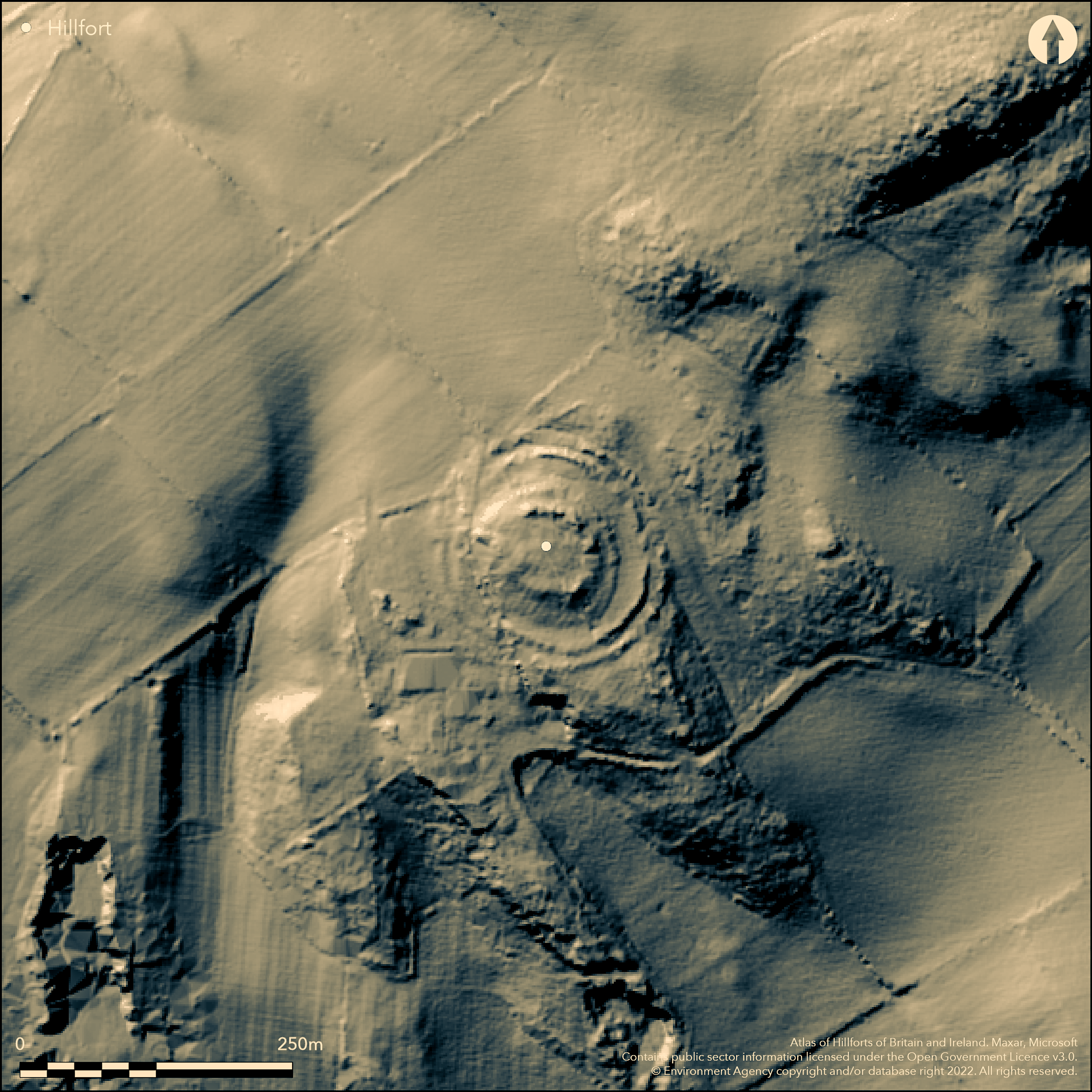
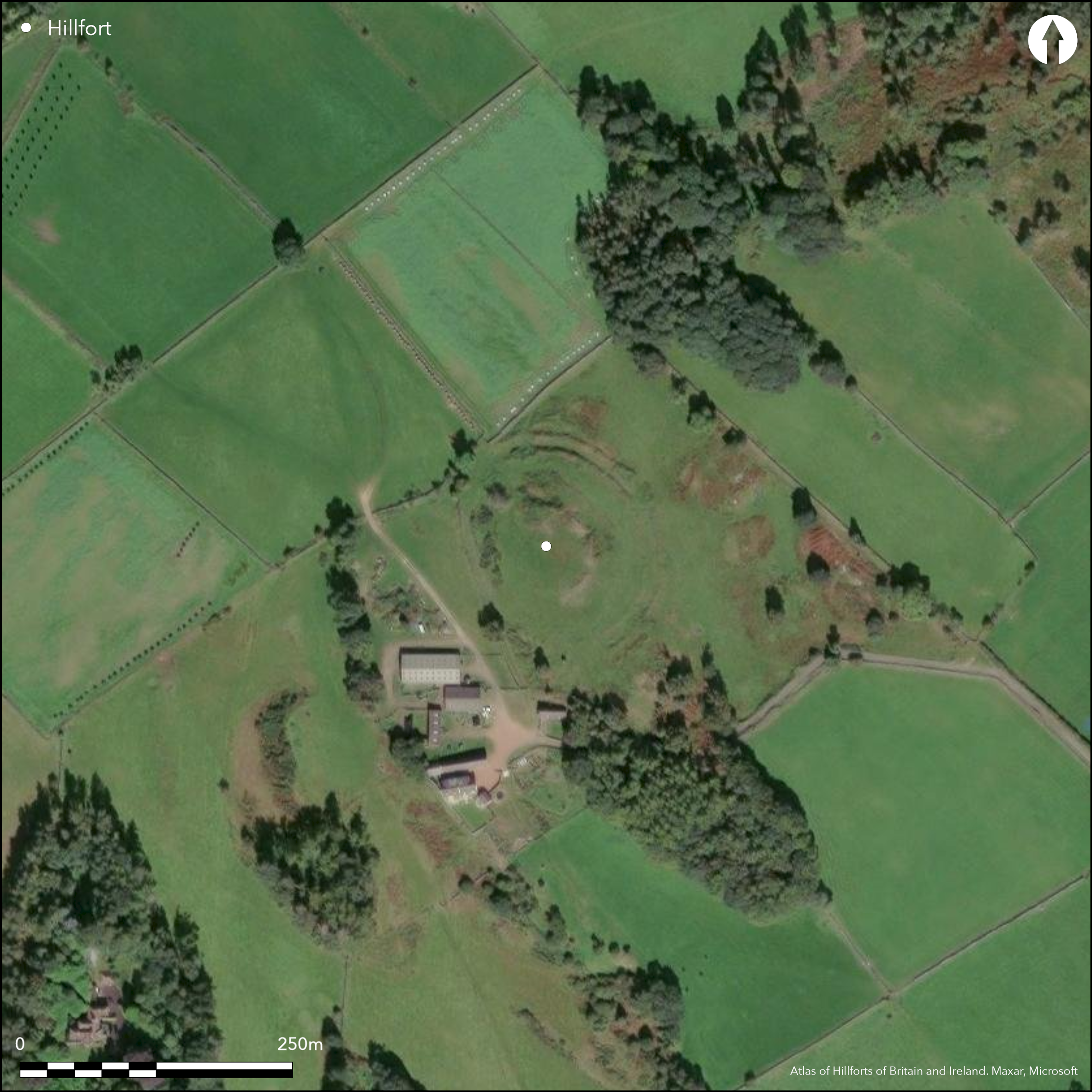
Lying at 167m OD on West Hills, overlooking the valley of the River Coquet and 650m to the W of Old Rothbury Hillfort (Atlas number 0590), a small multivallate hillfort of 0.15ha. A well-preserved inner rampart 1.5m high surrounded by a wide, level berm of between 6-16m. Two further earth and stone banks lie outside the berm with a 12m wide ditch between giving an overall measurement of 130m E-W by 140m N-S. The two banks survive up to 1.5m above the ditch, becoming less pronounced in the S. Three gaps through the ramparts in the E, two of which measure 33m across appear to be associated with staggered entrances and corresponding gaps through the inner rampart and probably represent the sites of original entrances. A field boundary cuts the enclosure NW-SE and destruction has occurred in the W. A field track cuts the western extent beyond which it is completely destroyed. No visible trace of internal structures are present. The hillfort is shown on 1856-65 OS mapping and was first scheduled in 1932. No investigation has been carried out and the site is undated but presumed Iron Age.
Citizen Science: ✗
Reliability of Data: Confirmed
Reliability of Interpretation: Confirmed
X: -216158 Y: 7422830 (EPSG: 3857)
Longitude: -1.9417807767502022 Latitude: 55.31289133523712 (EPSG:4326)
Country: England; None
Current County or Unitary Authority: Northumberland
Historic County: Northumberland
Current Parish/Community/Council/Townland: Rothbury
Partially levelled by ploughing in the W
| Extant | ✓ |
| Cropmark | ✗ |
| Likely Destroyed | ✓ |
Ploughed in the past, now rough grassland with gorse defining the ramparts in places
| Woodland | ✗ |
| Commercial Forestry Plantation | ✗ |
| Parkland | ✗ |
| Pasture (Grazing) | ✓ |
| Arable | ✗ |
| Scrub/Bracken | ✓ |
| Bare Outcrop | ✗ |
| Heather/Moorland | ✗ |
| Heath | ✗ |
| Built-up | ✗ |
| Coastal Grassland | ✗ |
| Other | ✗ |
A hillslope fort lying at 167m OD, occupying the highest point of a spur on the W of West Hill
| Contour Fort | ✗ |
| Partial Contour Fort | ✗ |
| Promontory Fort | ✗ |
| Hillslope Fort | ✓ |
| Level Terrain Fort | ✗ |
| Marsh Fort | ✗ |
| Multiple Enclosure Fort | ✗ |
| Hilltop | ✗ |
| Coastal Promontory | ✗ |
| Inland Promontory | ✗ |
| Valley Bottom | ✗ |
| Knoll/Hillock/Outcrop | ✗ |
| Ridge | ✗ |
| Cliff/Plateau-edge/Scarp | ✓ |
| Hillslope | ✓ |
| Lowland | ✗ |
| Spur | ✓ |
Dominant Topographic Feature: Occupies the highest point of a spur on the W of West Hill, overlooking the valley of the River Coquet
| North | ✗ |
| Northeast | ✗ |
| East | ✗ |
| Southeast | ✗ |
| South | ✗ |
| Southwest | ✓ |
| West | ✗ |
| Northwest | ✗ |
| Level | ✗ |
Altitude: 167.0m
Northern boundary of the hillfort lies on the boundary of Rothbury and Thropton
Boundary Type: Parish/Townland
Undated, presumed Iron Age
Reliability: D - None
| Pre 1200BC | ✗ |
| 1200BC - 800BC | ✗ |
| 800BC - 400BC | ✗ |
| 400BC - AD50 | ✗ |
| AD50 - AD400 | ✗ |
| AD400 - AD 800 | ✗ |
| Post AD800 | ✗ |
| Unknown | ✓ |
| Pre Hillfort: | None |
| Post Hillfort: | None |
| Morphology/Earthwork/Typology: | None |
Recorded on 1856-65 OS mapping; general reference in McLauchlan (1867) regarding features outside the hillfort, Hogg (1947). Field investigations 1957, 1971. Scheduled
| 1st Identified Written Reference (1867): | None |
| Other (1911): | Field investigation |
| Other (1932): | Scheduled |
| Other (1957): | Field investigation |
| 1st Identified Map Depiction (None): | None |
No known features; at least partly cultivated in shallow rigs
River Coquet to the S
| None | ✓ |
| Spring | ✗ |
| Stream | ✗ |
| Pool | ✗ |
| Flush | ✗ |
| Well | ✗ |
| Other | ✗ |
None
| No Known Features | ✓ |
| Round Stone Structures | ✗ |
| Rectangular Stone Structures | ✗ |
| Curvilinear Platforms | ✗ |
| Other Roundhouse Evidence | ✗ |
| Pits | ✗ |
| Quarry Hollows | ✗ |
| Other | ✗ |
None
| No Known Excavation | ✓ |
| Pits | ✗ |
| Postholes | ✗ |
| Roundhouses | ✗ |
| Rectangular Structures | ✗ |
| Roads/Tracks | ✗ |
| Quarry Hollows | ✗ |
| Other | ✗ |
| Nothing Found | ✗ |
None
| No Known Geophysics | ✓ |
| Pits | ✗ |
| Roundhouses | ✗ |
| Rectangular Structures | ✗ |
| Roads/Tracks | ✗ |
| Quarry Hollows | ✗ |
| Other | ✗ |
| Nothing Found | ✗ |
None
| No Known Finds | ✓ |
| Pottery | ✗ |
| Metal | ✗ |
| Metalworking | ✗ |
| Human Bones | ✗ |
| Animal Bones | ✗ |
| Lithics | ✗ |
| Environmental | ✗ |
| Other | ✗ |
None
| APs Not Checked | ✓ |
| None | ✗ |
| Roundhouses | ✗ |
| Rectangular Structures | ✗ |
| Pits | ✗ |
| Postholes | ✗ |
| Roads/Tracks | ✗ |
| Other | ✗ |
The number of entrances is unclear from written descriptions, but would imply up to 9 breaks - three gaps through the ramparts in the E, two of which measure 33m across appear to be associated with staggered entrances and corresponding gaps through the inner rampart thought to represent the sites of original entrances.
| 9: | There is some uncertaintly to this number |
| 2: | None |
Guard Chambers: ✗
Chevaux de Frise: ✗
| 1. Oblique (East): | Inner rampart, middle and outer represented by 33m wide gaps |
Well-preserved inner rampart 1.5m high surrounded by a wide, level berm of between 6-16m. Two further earth and stone banks lie outside the berm with a 12m wide ditch between giving an overall measurement of 130m E-W by 140m N-S. The two banks survive up to 1.5m above the ditch, becoming less pronounced in the S.
| Area 1: | 0.15ha. |
| Total: | 0.15ha. |
Total Footprint Area: 1.22ha.
None
| ✗ | Whole site footprint estimated from satellite imagery |
| ✓ | Now destroyed in the W |
| NE Quadrant: | 3 |
| SE Quadrant: | 3 |
| SW Quadrant: | 3 |
| NW Quadrant: | 3 |
| Total: | 3 |
| Partial Univallate | ✗ |
| Univallate | ✗ |
| Partial Bivallate | ✗ |
| Bivallate | ✗ |
| Partial Multivallate | ✗ |
| Multivallate | ✓ |
| Unknown | ✗ |
| Partial Univallate | ✗ |
| Univallate | ✗ |
| Partial Bivallate | ✗ |
| Bivallate | ✗ |
| Partial Multivallate | ✗ |
| Multivallate | ✗ |
None
| None | ✗ |
| Earthen Bank | ✓ |
| Stone Wall | ✗ |
| Rubble | ✓ |
| Wall-walk | ✗ |
| Evidence of Timber | ✗ |
| Vitrification | ✗ |
| Other Burning | ✗ |
| Palisade | ✗ |
| Counter Scarp Bank | ✗ |
| Berm | ✓ |
| Unfinished | ✗ |
| Other | ✗ |
None
| None | ✗ |
| Earthen Bank | ✗ |
| Stone Wall | ✗ |
| Murus Duplex | ✗ |
| Timber-framed | ✗ |
| Timber-laced | ✗ |
| Vitrification | ✗ |
| Other Burning | ✗ |
| Palisade | ✗ |
| Counter Scarp Bank | ✗ |
| Berm | ✗ |
| Unfinished | ✗ |
| No Known Excavation | ✓ |
| Other | ✗ |
| ✗ | None |
| ✓ | None |
Number of Ditches: 1
| ✗ | None |
Hogg, A.H.A.1979. British Hill-Forts. An Index. British Archaeological Reports, British Series 62. 123
Hogg, A.H.A. 1947. A new list of the native sites of Northumberland. Proc Soc Antiq Newcastle (4th Series) 11, 167.
MacLauchlan, H. 1867. Additional notes on Roman roads in Northumberland. 82-3
Atlas of Hillforts:
Wikidata:
This work is licensed under CC BY-SA 4.0![]()
![]()
![]() and should be cited as:
and should be cited as:
Lock, Gary and Ralston, Ian. 2024. Atlas of Hillforts of Britain and Ireland. Available at: https://hillforts.arch.ox.ac.uk
Document Version 1.1