LiDAR 1m DTM Hillshade
Satellite Imagery
LiDAR 1m DTM Hillshade
Satellite Imagery
Scroll left/right to view further images.
HER: Northumberland 8558 (None)
NMR: NY 96 NW 17 (18338)
SM: 1011421
NGR: NY 90423 67863
X: 390423 Y: 567863 (OSGB36)
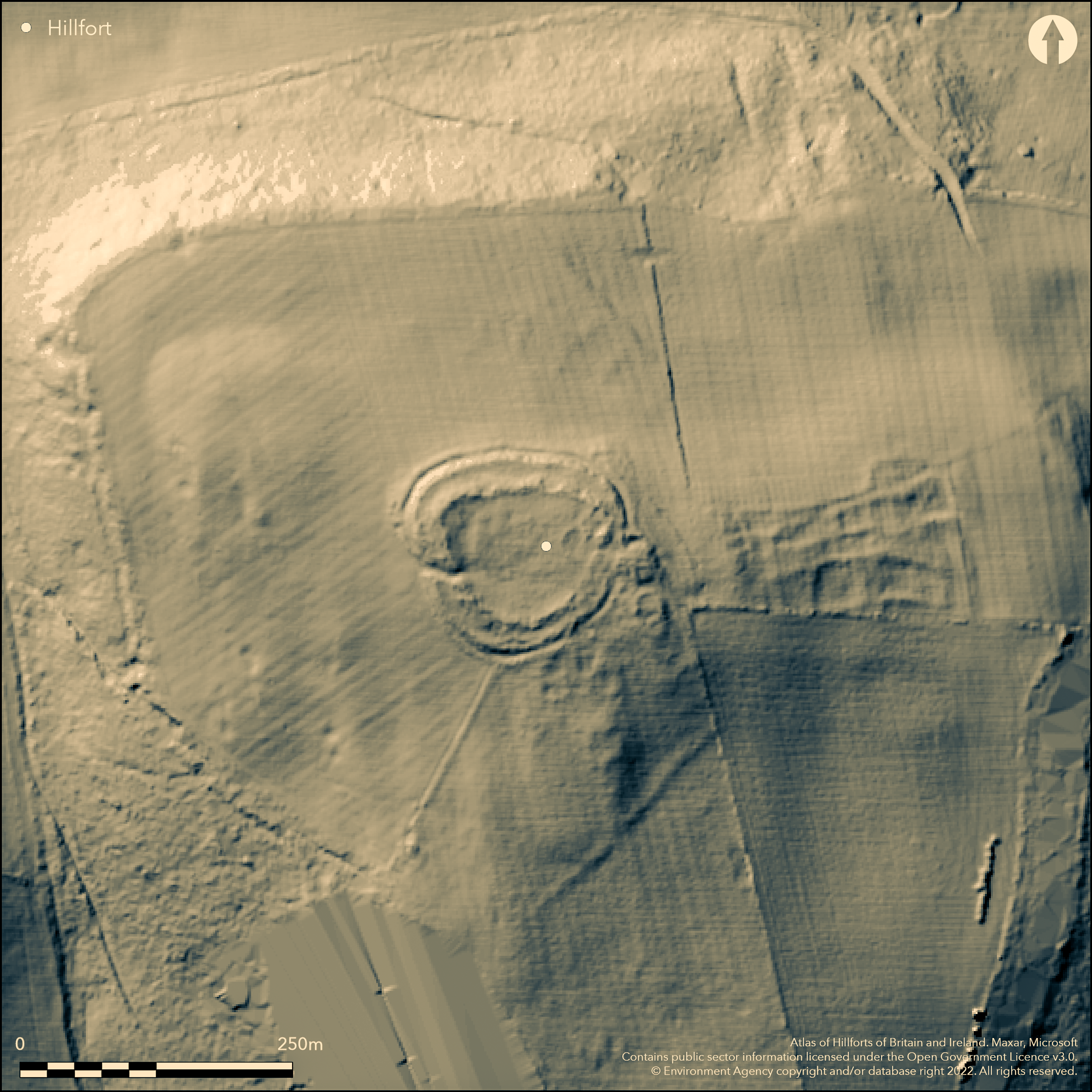
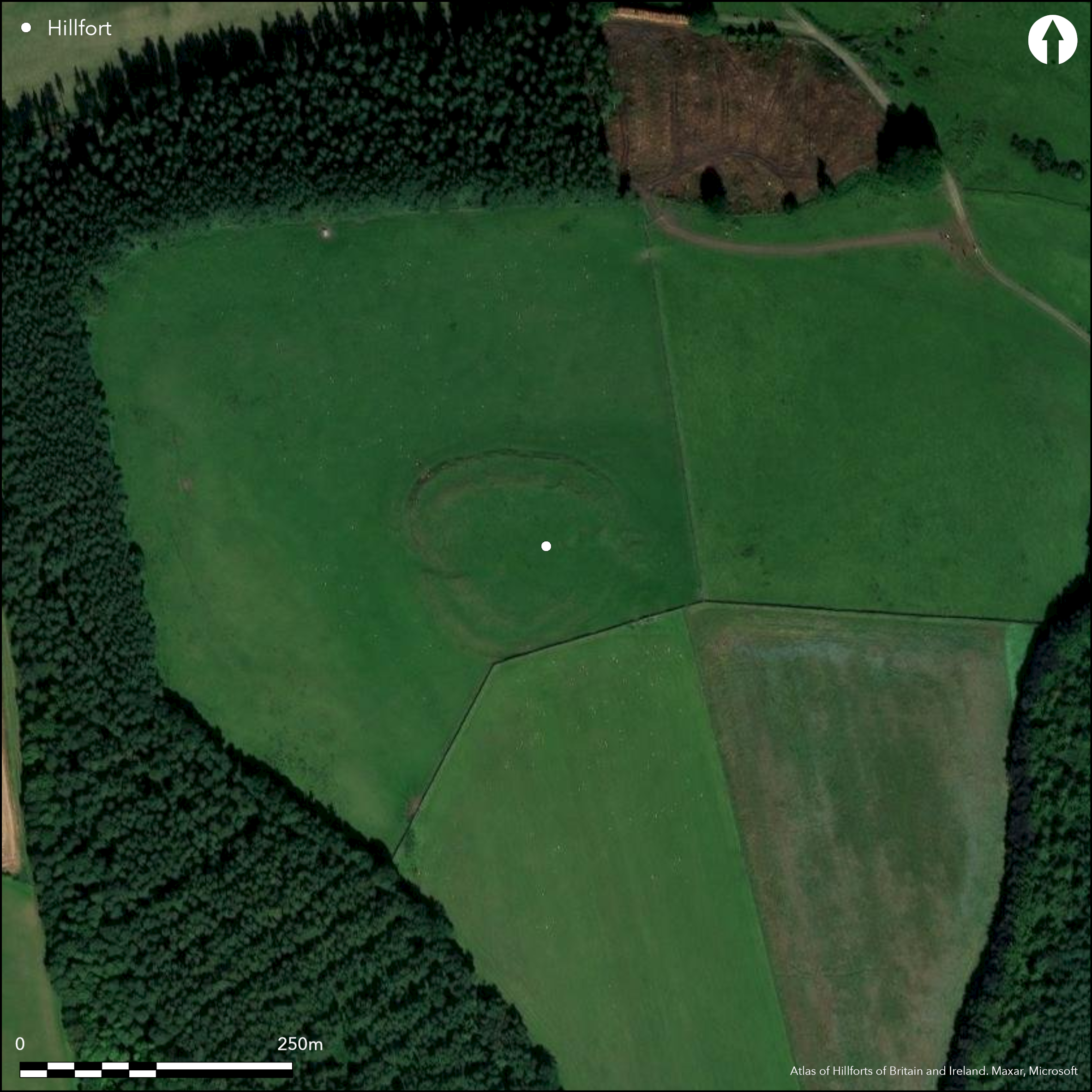
A small multivallate hillfort lying at 181m OD on the summit of Warden Hill, 900m to the NW of High Warden. Sub-circular in plan, it measures 85m E-W by 63m N-S. Damage and spreading of the ramparts has occurred and the whole site footprint is now 1.16ha. It lies between the Rivers North and South Tyne with their confluence in the SE with views in all directions. It comprises three ramparts and a ditch, with the medial ditch between the two outer ramparts. The Inner rampart is the most substantial measuring 6m wide and 2m high and where visible can be seen to be constructed of earth and stone with large facing stones. The two outer ramparts are 0.4 and 1.5m high. Separated by only 1.5m, the medial ditch is obscured by rampart material. A slightly in-turned entrances lies in the W. A gap in the E is caused by post medieval quarrying. The site of a small Roman period settlement overlying the NW corner, was recorded during scheduling but was unconfirmed by a later inspection of all aerial photographs which suggested the earthworks resulted from quarrying. Several querns are said to have been found within the fort (MacKenzie 1825). Maclauchlan (1857) reported a tumulus at the highest point but this is also unconfirmed. The site is now denuded and damaged by quarrying. A field wall crosses the outer rampart in the in the S. It is shown on 1856-65 OS mapping, and underwent a small area of geophysical survey in 1994 (Swaddle 1995) but nothing was recorded. it has not been excavated and is undated.
Citizen Science: ✗
Reliability of Data: Confirmed
Reliability of Interpretation: Confirmed
X: -239477 Y: 7362887 (EPSG: 3857)
Longitude: -2.1512617116145734 Latitude: 55.005261760763 (EPSG:4326)
Country: England
Current County or Unitary Authority: Northumberland
Historic County: Northumberland
Current Parish/Community/Council/Townland: Warden
Denuded and damaged by quarrying
| Extant | ✓ |
| Cropmark | ✗ |
| Likely Destroyed | ✗ |
Geology - Millstone Grit Series
| Woodland | ✗ |
| Commercial Forestry Plantation | ✗ |
| Parkland | ✗ |
| Pasture (Grazing) | ✓ |
| Arable | ✗ |
| Scrub/Bracken | ✗ |
| Bare Outcrop | ✗ |
| Heather/Moorland | ✗ |
| Heath | ✗ |
| Built-up | ✗ |
| Coastal Grassland | ✗ |
| Other | ✗ |
A contour fort lying on level ground at 181m OD on the summit of Warden Hill with views in all directions. It lies between the Rivers North and South Tyne with their confluence in the SE.
| Contour Fort | ✓ |
| Partial Contour Fort | ✗ |
| Promontory Fort | ✗ |
| Hillslope Fort | ✗ |
| Level Terrain Fort | ✗ |
| Marsh Fort | ✗ |
| Multiple Enclosure Fort | ✗ |
| Hilltop | ✓ |
| Coastal Promontory | ✗ |
| Inland Promontory | ✗ |
| Valley Bottom | ✗ |
| Knoll/Hillock/Outcrop | ✗ |
| Ridge | ✗ |
| Cliff/Plateau-edge/Scarp | ✗ |
| Hillslope | ✗ |
| Lowland | ✗ |
| Spur | ✗ |
Dominant Topographic Feature: Summit of Warden Hill
| North | ✗ |
| Northeast | ✗ |
| East | ✗ |
| Southeast | ✗ |
| South | ✗ |
| Southwest | ✓ |
| West | ✗ |
| Northwest | ✗ |
| Level | ✗ |
Altitude: 181.0m
N/A
Undated, presumed Iron Age
Reliability: D - None
| Pre 1200BC | ✗ |
| 1200BC - 800BC | ✗ |
| 800BC - 400BC | ✗ |
| 400BC - AD50 | ✗ |
| AD50 - AD400 | ✗ |
| AD400 - AD 800 | ✗ |
| Post AD800 | ✗ |
| Unknown | ✓ |
| Pre Hillfort: | None |
| Post Hillfort: | Possible Romano-British settlement, quarrying, trig point |
| Morphology/Earthwork/Typology: | None |
General reference in MacKenzie (1825) and shown on 1856-65 OS mapping. It was first scheduled in 1932. Field investigation 1966. Geophysical survey in 1994 (Swaddle 1995). Resistivity survey within and to the east of the hillfort to examine underlying archaeological features at the site as part of a BSc dissertation - nothing recorded
| 1st Identified Written Reference (1825): | None |
| Other (1932): | Scheduled |
| Other (1966): | Field investigation |
| Geophysical Survey (1994): | None |
| 1st Identified Map Depiction (None): | None |
Curvilinear features are visible in the NW of the fort and interpreted as Romano-British settlement, but earthworks could have resulted from quarrying
None
| None | ✓ |
| Spring | ✗ |
| Stream | ✗ |
| Pool | ✗ |
| Flush | ✗ |
| Well | ✗ |
| Other | ✗ |
Could result from quarrying
| No Known Features | ✗ |
| Round Stone Structures | ✗ |
| Rectangular Stone Structures | ✗ |
| Curvilinear Platforms | ✓ |
| Other Roundhouse Evidence | ✗ |
| Pits | ✗ |
| Quarry Hollows | ✗ |
| Other | ✗ |
None
| No Known Excavation | ✓ |
| Pits | ✗ |
| Postholes | ✗ |
| Roundhouses | ✗ |
| Rectangular Structures | ✗ |
| Roads/Tracks | ✗ |
| Quarry Hollows | ✗ |
| Other | ✗ |
| Nothing Found | ✗ |
None
| No Known Geophysics | ✗ |
| Pits | ✗ |
| Roundhouses | ✗ |
| Rectangular Structures | ✗ |
| Roads/Tracks | ✗ |
| Quarry Hollows | ✗ |
| Other | ✗ |
| Nothing Found | ✓ |
Several querns are said to have been found within the fort (MacKenzie 1825)
| No Known Finds | ✗ |
| Pottery | ✗ |
| Metal | ✗ |
| Metalworking | ✗ |
| Human Bones | ✗ |
| Animal Bones | ✗ |
| Lithics | ✗ |
| Environmental | ✗ |
| Other | ✓ |
None
| APs Not Checked | ✓ |
| None | ✗ |
| Roundhouses | ✗ |
| Rectangular Structures | ✗ |
| Pits | ✗ |
| Postholes | ✗ |
| Roads/Tracks | ✗ |
| Other | ✗ |
A slightly in-turned entrance lies in the W
| 2: | Later break in the E |
| 2: | None |
Guard Chambers: ✗
Chevaux de Frise: ✗
| 1. In-turned (West): | None |
Subcircular in plan, measuring 85m E-W by 63m N-S. Damage and spreading of the ramparts has occurred and the whole site footprint is now 1.16ha. It comprises three ramparts and a ditch, with the medial ditch between the two outer ramparts. The inner rampart is the most substantial measuring 6m wide and 2m high and where visible can be seen to be constructed of earth and stone with large facing stones. The two outer ramparts are 0.4 and 1.5m high. Separated by only 1.5m, the medial ditch is obscured by rampart material.
| Area 1: | 0.32ha. |
| Total: | 0.32ha. |
Total Footprint Area: 1.16ha.
None
| ✗ | Whole site footprint estimated from satellite imagery. The internal area is now obscured and measurement taken from Hogg (1979) |
| ✓ | None |
| NE Quadrant: | 3 |
| SE Quadrant: | 3 |
| SW Quadrant: | 3 |
| NW Quadrant: | 3 |
| Total: | 3 |
| Partial Univallate | ✗ |
| Univallate | ✗ |
| Partial Bivallate | ✗ |
| Bivallate | ✗ |
| Partial Multivallate | ✗ |
| Multivallate | ✓ |
| Unknown | ✗ |
| Partial Univallate | ✗ |
| Univallate | ✗ |
| Partial Bivallate | ✗ |
| Bivallate | ✗ |
| Partial Multivallate | ✗ |
| Multivallate | ✗ |
None
| None | ✗ |
| Earthen Bank | ✓ |
| Stone Wall | ✓ |
| Rubble | ✓ |
| Wall-walk | ✗ |
| Evidence of Timber | ✗ |
| Vitrification | ✗ |
| Other Burning | ✗ |
| Palisade | ✗ |
| Counter Scarp Bank | ✗ |
| Berm | ✗ |
| Unfinished | ✗ |
| Other | ✗ |
None
| None | ✗ |
| Earthen Bank | ✗ |
| Stone Wall | ✗ |
| Murus Duplex | ✗ |
| Timber-framed | ✗ |
| Timber-laced | ✗ |
| Vitrification | ✗ |
| Other Burning | ✗ |
| Palisade | ✗ |
| Counter Scarp Bank | ✗ |
| Berm | ✗ |
| Unfinished | ✗ |
| No Known Excavation | ✓ |
| Other | ✗ |
| ✗ | None |
| ✓ | None |
Number of Ditches: 1
| ✗ | None |
Hogg, A.H.A.1979. British Hill-Forts. An Index. British Archaeological Reports, British Series 62. 141
MacKenzie, E., 1825. History of Northumberland 2 (Newcastle), 260
MacLauchlan, H. 1858. Memoir written during a survey of the Roman wall, through the counties of Northumberland and Cumberland, in the years 1852-1854. 34
Swaddle P. Warden Hillfort, A Geophysical Survey and Small Scale Study of Warden Hillfort and the Immediate Surrounding Area. Unpublished.
Atlas of Hillforts:
Wikidata:
This work is licensed under CC BY-SA 4.0![]()
![]()
![]() and should be cited as:
and should be cited as:
Lock, Gary and Ralston, Ian. 2024. Atlas of Hillforts of Britain and Ireland. Available at: https://hillforts.arch.ox.ac.uk
Document Version 1.1