LiDAR 1m DTM Hillshade
Satellite Imagery
LiDAR 1m DTM Hillshade
Satellite Imagery
Scroll left/right to view further images.
HER: Cornwall and Scilly MCO38379 (25312)
NMR: SW 76 SE 4 (428420)
SM: 1020026
NGR: SW76846070
X: 176845 Y: 60708 (OSGB36)
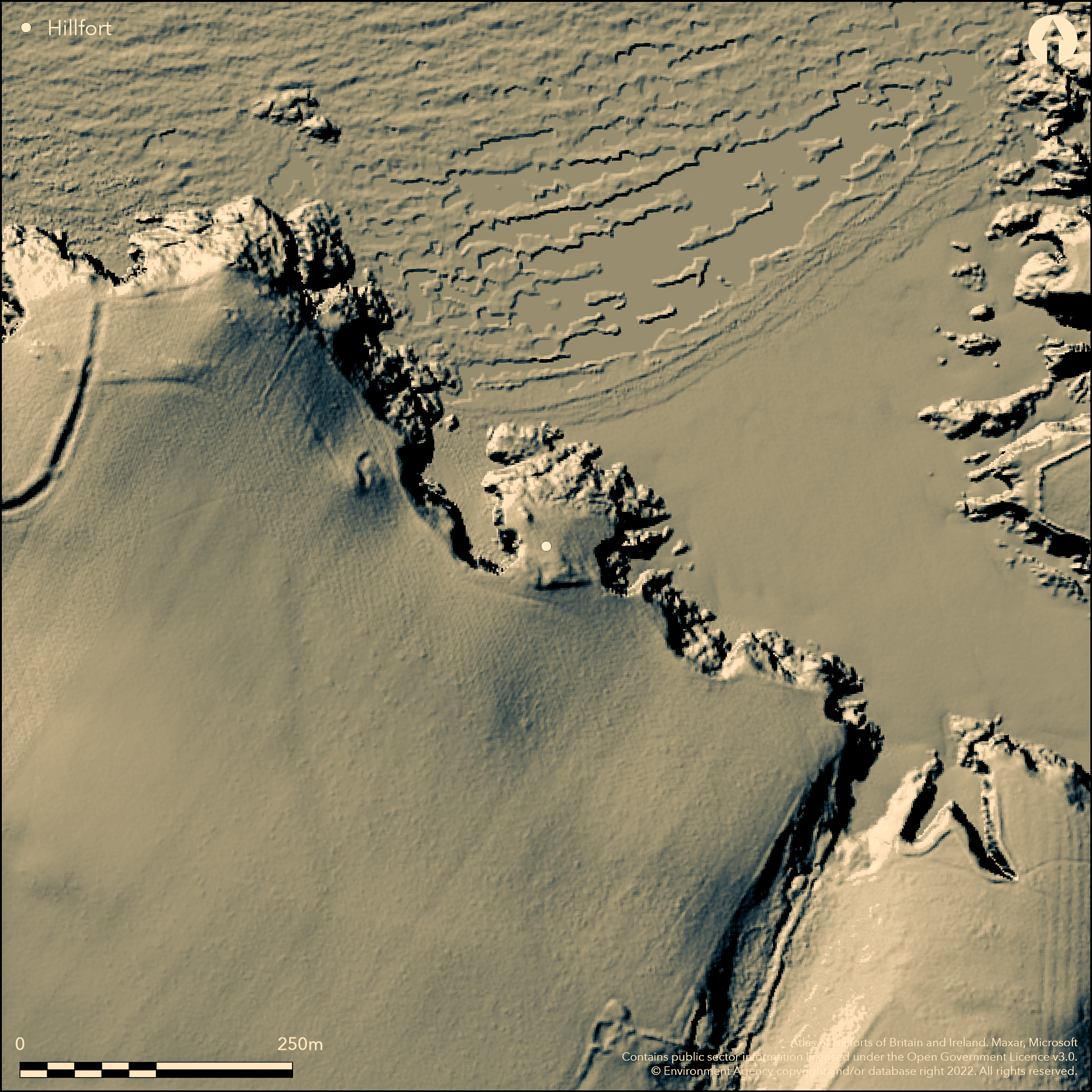
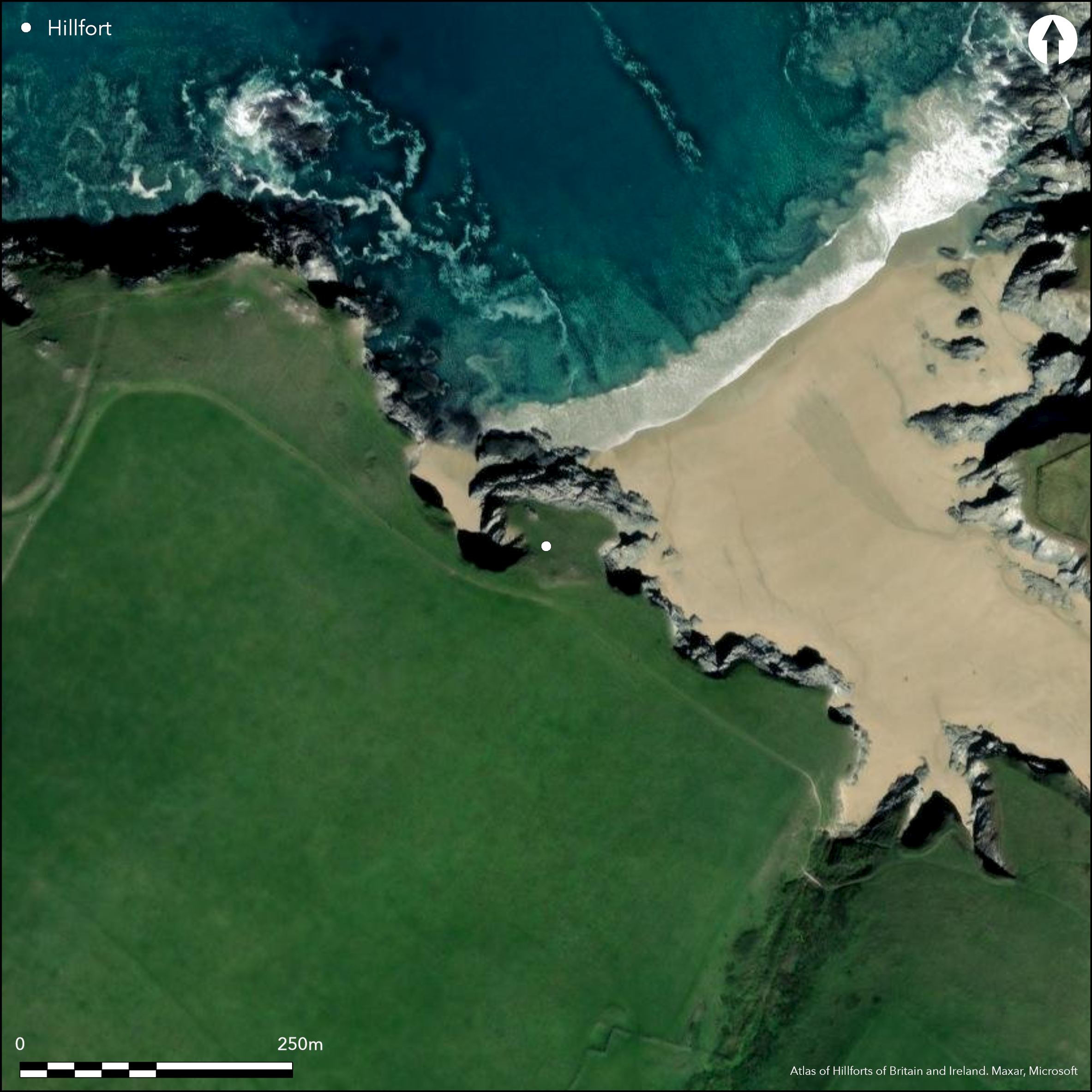
Small promontory fort lying on single promontory spur west of Porth Joke, at Inner Kelsey, seaward part of The Kelseys, headland SW of Newquay and E of Kelsey Head (Atlas No 3718). Sea cliffs to N, E, W. Irregular plan reflecting topography of cliffs, measuring c. 50m across enclosing 1.5ha. Rampart of earth and stone incorporates natural rock across neck of promontory, curving S and generally c. 6m wide and 0.8m-1.5m high outside, 0.3m-1.1m high inside, but very slight for c.7m from the cliff on E. Possible ditch. Original entrance possibly near centre of rampart, where it dips by c. 0.5m for some 3m. Interior falls towards cliffs with natural slope, broken by outcrops of bedrock, except inside the entrance where it forms a natural or modified platform c. 8m across and 0.8m high above the slope. Coastal grassland and site being eroded by sea. Minimal investigations recorded. Undated. On 1st Edition OS map (1885-1900).
Citizen Science: ✗
Reliability of Data: Confirmed
Reliability of Interpretation: Confirmed
X: -572381 Y: 6516487 (EPSG: 3857)
Longitude: -5.141790041628419 Latitude: 50.40370679076362 (EPSG:4326)
Country: England
Current County or Unitary Authority: Cornwall
Historic County: Cornwall
Current Parish/Community/Council/Townland: Cubert
Sea eroding site.
| Extant | ✓ |
| Cropmark | ✗ |
| Likely Destroyed | ✗ |
Coastal grassland and bare rock.
| Woodland | ✗ |
| Commercial Forestry Plantation | ✗ |
| Parkland | ✗ |
| Pasture (Grazing) | ✗ |
| Arable | ✗ |
| Scrub/Bracken | ✗ |
| Bare Outcrop | ✗ |
| Heather/Moorland | ✗ |
| Heath | ✗ |
| Built-up | ✗ |
| Coastal Grassland | ✓ |
| Other | ✗ |
Small promontory fort (aka cliff castle) lying on single promontory spur west of Porth Joke, at Inner Kelsey, seaward part of The Kelseys, headland SW of Newquay. Sea cliffs to N, E, W.
| Contour Fort | ✗ |
| Partial Contour Fort | ✗ |
| Promontory Fort | ✓ |
| Hillslope Fort | ✗ |
| Level Terrain Fort | ✗ |
| Marsh Fort | ✗ |
| Multiple Enclosure Fort | ✗ |
Located on a prominent spur, the interior falling towards the cliffs with the natural slope
| Hilltop | ✗ |
| Coastal Promontory | ✓ |
| Inland Promontory | ✗ |
| Valley Bottom | ✗ |
| Knoll/Hillock/Outcrop | ✗ |
| Ridge | ✗ |
| Cliff/Plateau-edge/Scarp | ✗ |
| Hillslope | ✗ |
| Lowland | ✗ |
| Spur | ✗ |
Dominant Topographic Feature: Coastal promontory spur.
| North | ✗ |
| Northeast | ✓ |
| East | ✗ |
| Southeast | ✗ |
| South | ✗ |
| Southwest | ✗ |
| West | ✗ |
| Northwest | ✗ |
| Level | ✗ |
Altitude: 15.4m
N/A
None
Reliability: D - None
| Pre 1200BC | ✗ |
| 1200BC - 800BC | ✗ |
| 800BC - 400BC | ✗ |
| 400BC - AD50 | ✗ |
| AD50 - AD400 | ✗ |
| AD400 - AD 800 | ✗ |
| Post AD800 | ✗ |
| Unknown | ✓ |
| Pre Hillfort: | None |
| Post Hillfort: | None |
On 1st Edition OS map (1885-1900).
| 1st Identified Map Depiction (None): | None |
None
None visible
| None | ✓ |
| Spring | ✗ |
| Stream | ✗ |
| Pool | ✗ |
| Flush | ✗ |
| Well | ✗ |
| Other | ✗ |
None
| No Known Features | ✓ |
| Round Stone Structures | ✗ |
| Rectangular Stone Structures | ✗ |
| Curvilinear Platforms | ✗ |
| Other Roundhouse Evidence | ✗ |
| Pits | ✗ |
| Quarry Hollows | ✗ |
| Other | ✗ |
None
| No Known Excavation | ✓ |
| Pits | ✗ |
| Postholes | ✗ |
| Roundhouses | ✗ |
| Rectangular Structures | ✗ |
| Roads/Tracks | ✗ |
| Quarry Hollows | ✗ |
| Other | ✗ |
| Nothing Found | ✗ |
None
| No Known Geophysics | ✓ |
| Pits | ✗ |
| Roundhouses | ✗ |
| Rectangular Structures | ✗ |
| Roads/Tracks | ✗ |
| Quarry Hollows | ✗ |
| Other | ✗ |
| Nothing Found | ✗ |
None
| No Known Finds | ✓ |
| Pottery | ✗ |
| Metal | ✗ |
| Metalworking | ✗ |
| Human Bones | ✗ |
| Animal Bones | ✗ |
| Lithics | ✗ |
| Environmental | ✗ |
| Other | ✗ |
None
| APs Not Checked | ✓ |
| None | ✗ |
| Roundhouses | ✗ |
| Rectangular Structures | ✗ |
| Pits | ✗ |
| Postholes | ✗ |
| Roads/Tracks | ✗ |
| Other | ✗ |
Possible simple gap original entrance possibly near centre of rampart, where it dips by c. 0.5m for some 3m. Interior falls towards cliffs with natural slope, broken by outcrops of bedrock, except inside the entrance where it forms a natural or modified platform c. 8m across and 0.8m high above the slope.
| 1: | Rampart dips suggesting entrance. |
| 2: | None |
Guard Chambers: ✗
Chevaux de Frise: ✗
| 1. Simple Gap (North): | Possible simple gap |
Irregular plan reflecting topography of cliffs, measuring c. 50m across. Rampart of earth and stone incorporates natural rock across neck of promontory, curving S and generally c. 6m wide and 0.8m-1.5m high outside, 0.3m-1.1m high inside, but very slight for c.7m from the cliff on E. Possible ditch.
| Area 1: | 1.5ha. |
| Total: | 1.5ha. |
Total Footprint Area: Noneha.
None
| ✗ | None |
| ✗ | Rampart curves S across promontory. |
| NE Quadrant: | 0 |
| SE Quadrant: | 1 |
| SW Quadrant: | 1 |
| NW Quadrant: | 0 |
| Total: | 1 |
| Partial Univallate | ✓ |
| Univallate | ✗ |
| Partial Bivallate | ✗ |
| Bivallate | ✗ |
| Partial Multivallate | ✗ |
| Multivallate | ✗ |
| Unknown | ✗ |
| Partial Univallate | ✗ |
| Univallate | ✗ |
| Partial Bivallate | ✗ |
| Bivallate | ✗ |
| Partial Multivallate | ✗ |
| Multivallate | ✗ |
Rampart of earth and stone incorporates natural rock across neck of promontory.
| None | ✗ |
| Earthen Bank | ✓ |
| Stone Wall | ✗ |
| Rubble | ✓ |
| Wall-walk | ✗ |
| Evidence of Timber | ✗ |
| Vitrification | ✗ |
| Other Burning | ✗ |
| Palisade | ✗ |
| Counter Scarp Bank | ✗ |
| Berm | ✗ |
| Unfinished | ✗ |
| Other | ✓ |
None
| None | ✗ |
| Earthen Bank | ✗ |
| Stone Wall | ✗ |
| Murus Duplex | ✗ |
| Timber-framed | ✗ |
| Timber-laced | ✗ |
| Vitrification | ✗ |
| Other Burning | ✗ |
| Palisade | ✗ |
| Counter Scarp Bank | ✗ |
| Berm | ✗ |
| Unfinished | ✗ |
| No Known Excavation | ✓ |
| Other | ✗ |
| ✗ | None |
| ✓ | Possible ditch. |
Number of Ditches: 1
| ✗ | None |
Harding, J.R. 1950. The prehistoric sites of the north Cornish coast, Antiq J, 30, 163-65.
Pattison, S.R. 1849. Annual report of the Royal Institution of Cornwall, Annual Report of the Royal Institution of Cornwall,31, 36-7.
Atlas of Hillforts:
Wikidata:
This work is licensed under CC BY-SA 4.0![]()
![]()
![]() and should be cited as:
and should be cited as:
Lock, Gary and Ralston, Ian. 2024. Atlas of Hillforts of Britain and Ireland. Available at: https://hillforts.arch.ox.ac.uk
Document Version 1.1