LiDAR 1m DTM Hillshade
Satellite Imagery
LiDAR 1m DTM Hillshade
Satellite Imagery
Scroll left/right to view further images.
HER: Cornwall and Scilly MCO35 (16048)
NMR: SW 42 NW 6 (422255)
SM: 1006717
NGR: SW40752903
X: 140750 Y: 29030 (OSGB36)
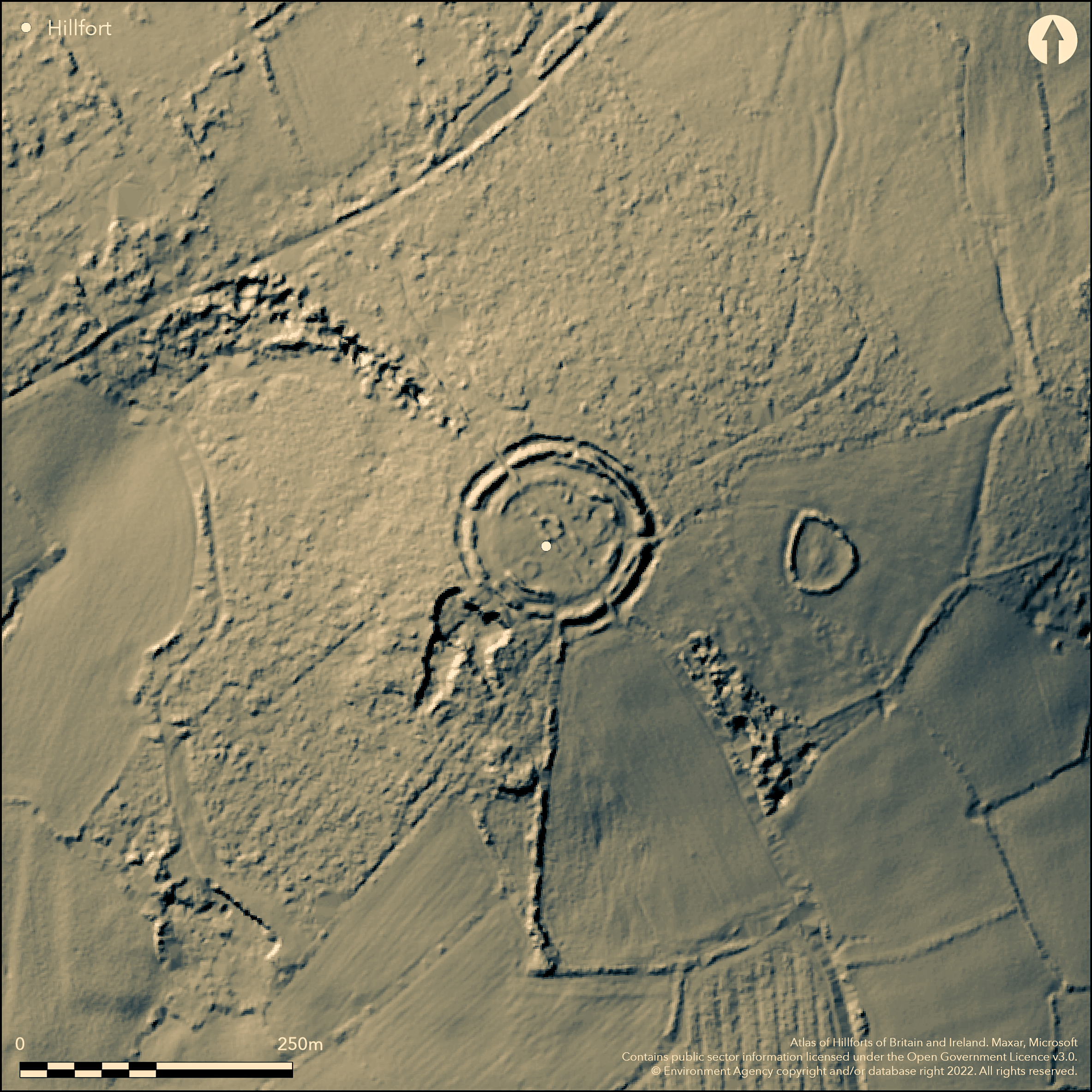
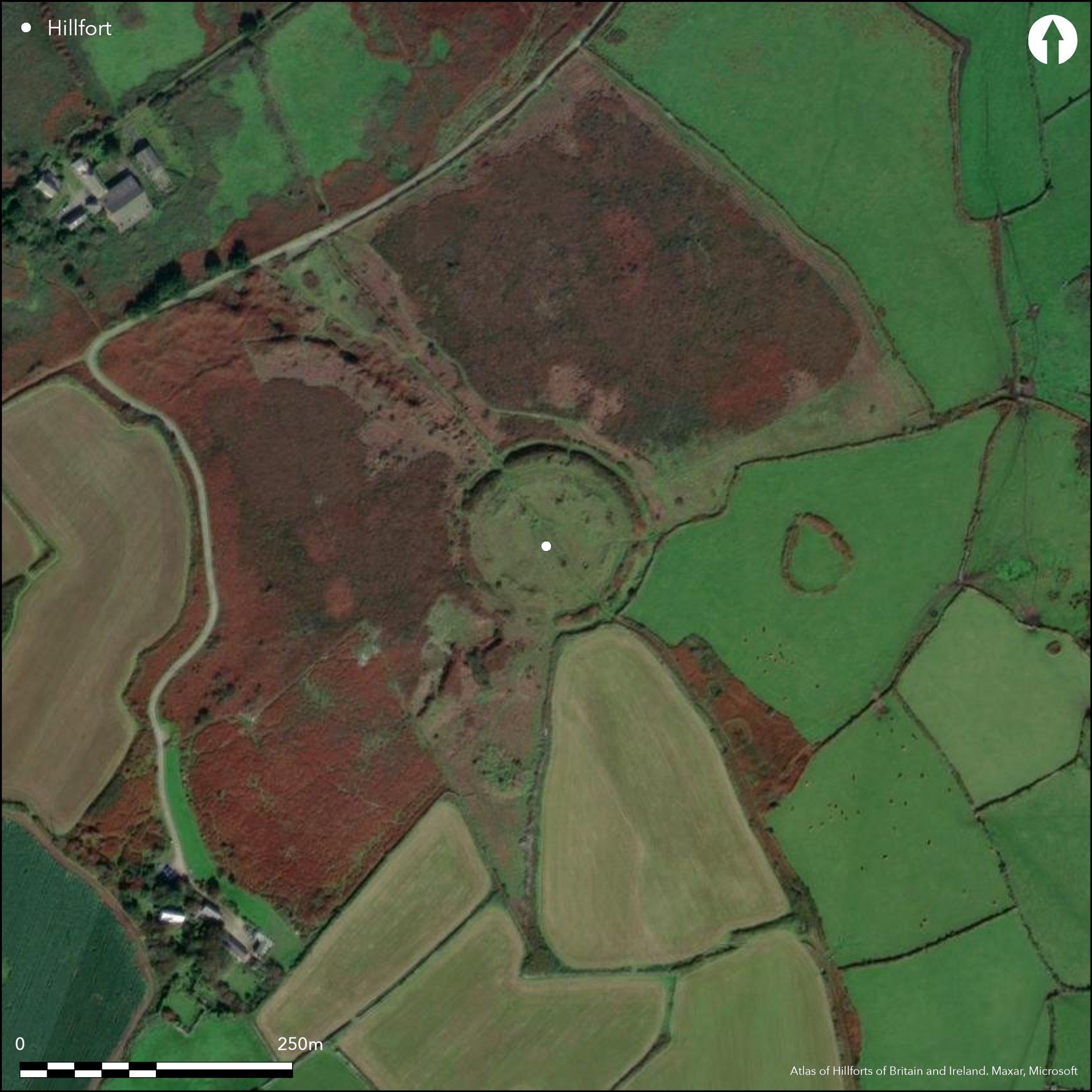
Bivallate, circular, contour hillfort situated on summit of prominent hill Caer Bran, Sancreed. Moderate to steep slopes surround site, steeper to N. Outer dimensions 120m by 130m; inner 60m diameter, encloses c. 0.5ha. Possible phased construction. Inner circuit formed by rampart and ditch and outer by rampart, outer ditch and counterscarp bank. Ramparts survive differentially; inner rampart and ditch much slighter than outer, the rampart of which up to 4.6m high and ditch 2m deep. Outer survives best to N. Inner rampart robbed of stone and part gone. Slight NW counterscarp. Possible NW entrance. Modern field boundary crosses site with prospecting pit damage. Within interior low rubble walls of, at least, two stone hut circles. Best preserved in centre, measuring c. 16m diameter. This hut circle and fort bisected by later track, and much of interior of site damaged by numerous pits and spoil heaps associated with mineral prospecting and extraction from medieval period onwards. Has also been referred to as a 'defended enclosure'. Moorland site. On 1st Ed. OS map (1876-78). Assessment Cornwall CC. 1997. Undated.
Citizen Science: ✗
Reliability of Data: Confirmed
Reliability of Interpretation: Confirmed
X: -626401 Y: 6464405 (EPSG: 3857)
Longitude: -5.627055733333003 Latitude: 50.10457018304787 (EPSG:4326)
Country: England
Current County or Unitary Authority: Cornwall
Historic County: Cornwall
Current Parish/Community/Council/Townland: Sancreed
Inner ramparts robbed of stone and part gone. Field boundary crosses site and numerous pits and spoil heaps associated with mineral prospecting and extraction from medieval period onwards.
| Extant | ✓ |
| Cropmark | ✗ |
| Likely Destroyed | ✗ |
Dense moorland vegetation. Spoil heaps.
| Woodland | ✗ |
| Commercial Forestry Plantation | ✗ |
| Parkland | ✗ |
| Pasture (Grazing) | ✗ |
| Arable | ✗ |
| Scrub/Bracken | ✓ |
| Bare Outcrop | ✗ |
| Heather/Moorland | ✓ |
| Heath | ✗ |
| Built-up | ✗ |
| Coastal Grassland | ✗ |
| Other | ✓ |
Bivallate, circular, contour hillfort situated on summit of prominent Caer Bran hill, Sancreed.
| Contour Fort | ✓ |
| Partial Contour Fort | ✗ |
| Promontory Fort | ✗ |
| Hillslope Fort | ✗ |
| Level Terrain Fort | ✗ |
| Marsh Fort | ✗ |
| Multiple Enclosure Fort | ✗ |
Located on the summit of Brane Hill
| Hilltop | ✓ |
| Coastal Promontory | ✗ |
| Inland Promontory | ✗ |
| Valley Bottom | ✗ |
| Knoll/Hillock/Outcrop | ✗ |
| Ridge | ✗ |
| Cliff/Plateau-edge/Scarp | ✗ |
| Hillslope | ✗ |
| Lowland | ✗ |
| Spur | ✗ |
Dominant Topographic Feature: Prominent hill.
| North | ✗ |
| Northeast | ✗ |
| East | ✗ |
| Southeast | ✗ |
| South | ✗ |
| Southwest | ✗ |
| West | ✗ |
| Northwest | ✗ |
| Level | ✓ |
Altitude: 195.0m
N/A
None
Reliability: D - None
| Pre 1200BC | ✗ |
| 1200BC - 800BC | ✗ |
| 800BC - 400BC | ✗ |
| 400BC - AD50 | ✗ |
| AD50 - AD400 | ✗ |
| AD400 - AD 800 | ✗ |
| Post AD800 | ✗ |
| Unknown | ✓ |
| Pre Hillfort: | Possible Bronze Age connotations - no details. |
| Post Hillfort: | Mineral prospecting and extraction from medieval period onwards. |
Sketch by Borlase 1769. Survey. On 1st Ed. OS map (1876-78). Survey 1908 - no details. Aerial assessment for management plan to Penwith District Council, Cornwall CC 1997.
| 1st Identified Written Reference (1769): | Borlase sketch.. |
| Other (1908): | No details. |
| Other (1997): | Cornwall CC survey. |
| Other (2006): | Visited by Hillfort Study Group |
| 1st Identified Map Depiction (None): | OS map. |
Low rubble walls of at least two stone hut circles.
None
| None | ✓ |
| Spring | ✗ |
| Stream | ✗ |
| Pool | ✗ |
| Flush | ✗ |
| Well | ✗ |
| Other | ✗ |
Low rubble walls of at least two stone hut circles.
| No Known Features | ✗ |
| Round Stone Structures | ✓ |
| Rectangular Stone Structures | ✗ |
| Curvilinear Platforms | ✗ |
| Other Roundhouse Evidence | ✗ |
| Pits | ✗ |
| Quarry Hollows | ✗ |
| Other | ✗ |
None
| No Known Excavation | ✓ |
| Pits | ✗ |
| Postholes | ✗ |
| Roundhouses | ✗ |
| Rectangular Structures | ✗ |
| Roads/Tracks | ✗ |
| Quarry Hollows | ✗ |
| Other | ✗ |
| Nothing Found | ✗ |
None
| No Known Geophysics | ✓ |
| Pits | ✗ |
| Roundhouses | ✗ |
| Rectangular Structures | ✗ |
| Roads/Tracks | ✗ |
| Quarry Hollows | ✗ |
| Other | ✗ |
| Nothing Found | ✗ |
None
| No Known Finds | ✓ |
| Pottery | ✗ |
| Metal | ✗ |
| Metalworking | ✗ |
| Human Bones | ✗ |
| Animal Bones | ✗ |
| Lithics | ✗ |
| Environmental | ✗ |
| Other | ✗ |
Aerial assessment for management Plan - Penwith District Council 1997.
| APs Not Checked | ✓ |
| None | ✗ |
| Roundhouses | ✗ |
| Rectangular Structures | ✗ |
| Pits | ✗ |
| Postholes | ✗ |
| Roads/Tracks | ✗ |
| Other | ✗ |
Possible NW entrance.
| 1: | None |
| 2: | None |
Guard Chambers: ✗
Chevaux de Frise: ✗
| 1. Simple Gap (North west): | None |
Inner circuit formed by rampart and ditch and outer by rampart, outer ditch and counterscarp bank. The defences survive differentially; inner rampart and ditch are much slighter in construction than outer, the rampart of which is up to 4.6m high and ditch 2m deep. Outer defences survive best to the N. Inner rampart robbed of stone and part gone. Slight NW counterscarp.
| Area 1: | 0.5ha. |
| Total: | 0.5ha. |
Total Footprint Area: Noneha.
None
| ✓ | Possible phased construction. |
| ✓ | None |
| NE Quadrant: | 2 |
| SE Quadrant: | 2 |
| SW Quadrant: | 2 |
| NW Quadrant: | 2 |
| Total: | 2 |
| Partial Univallate | ✗ |
| Univallate | ✗ |
| Partial Bivallate | ✗ |
| Bivallate | ✓ |
| Partial Multivallate | ✗ |
| Multivallate | ✗ |
| Unknown | ✗ |
| Partial Univallate | ✗ |
| Univallate | ✓ |
| Partial Bivallate | ✗ |
| Bivallate | ✗ |
| Partial Multivallate | ✗ |
| Multivallate | ✗ |
Slight NW counterscarp.
| None | ✗ |
| Earthen Bank | ✓ |
| Stone Wall | ✓ |
| Rubble | ✓ |
| Wall-walk | ✗ |
| Evidence of Timber | ✗ |
| Vitrification | ✗ |
| Other Burning | ✗ |
| Palisade | ✗ |
| Counter Scarp Bank | ✓ |
| Berm | ✗ |
| Unfinished | ✗ |
| Other | ✗ |
None
| None | ✗ |
| Earthen Bank | ✗ |
| Stone Wall | ✗ |
| Murus Duplex | ✗ |
| Timber-framed | ✗ |
| Timber-laced | ✗ |
| Vitrification | ✗ |
| Other Burning | ✗ |
| Palisade | ✗ |
| Counter Scarp Bank | ✗ |
| Berm | ✗ |
| Unfinished | ✗ |
| No Known Excavation | ✓ |
| Other | ✗ |
| ✗ | None |
| ✓ | None |
Number of Ditches: 2
| ✗ | None |
Lawson Jones, A. and Herring, P.1997. Report to Penwith District Council: Caer Bran, an Archaeological Assessment, Unpublished assessment and evaluation report, Cornwall Archaeological Unit, Cornwall County Council.
Atlas of Hillforts:
Wikidata:
This work is licensed under CC BY-SA 4.0![]()
![]()
![]() and should be cited as:
and should be cited as:
Lock, Gary and Ralston, Ian. 2024. Atlas of Hillforts of Britain and Ireland. Available at: https://hillforts.arch.ox.ac.uk
Document Version 1.1