LiDAR 1m DTM Hillshade
Satellite Imagery
LiDAR 1m DTM Hillshade
Satellite Imagery
Scroll left/right to view further images.
HER: Cornwall and Scilly MCO33 (1539)
NMR: SX 16 NW 8 (432566)
SM: 1004457
NGR: SX13536962
X: 213530 Y: 69620 (OSGB36)
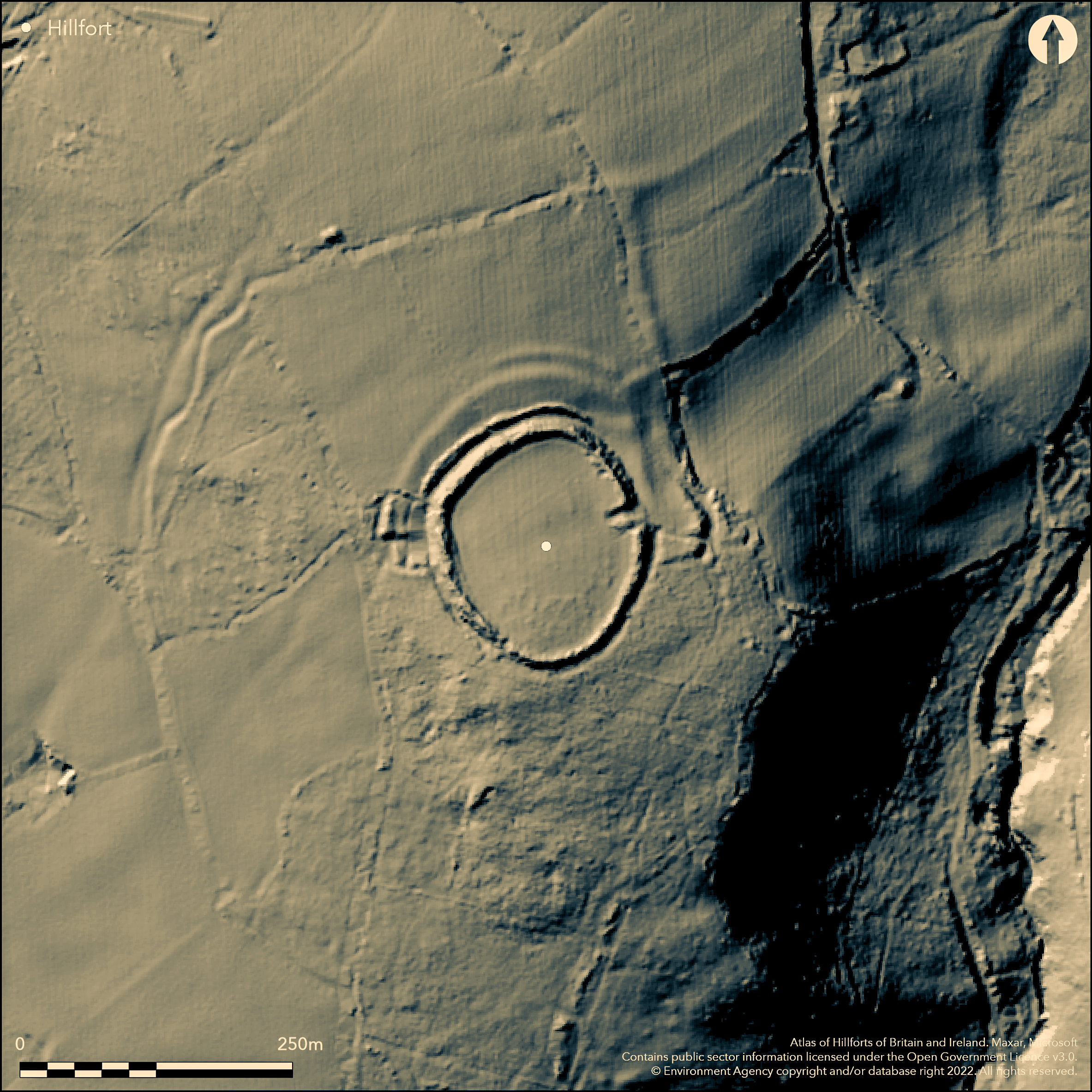
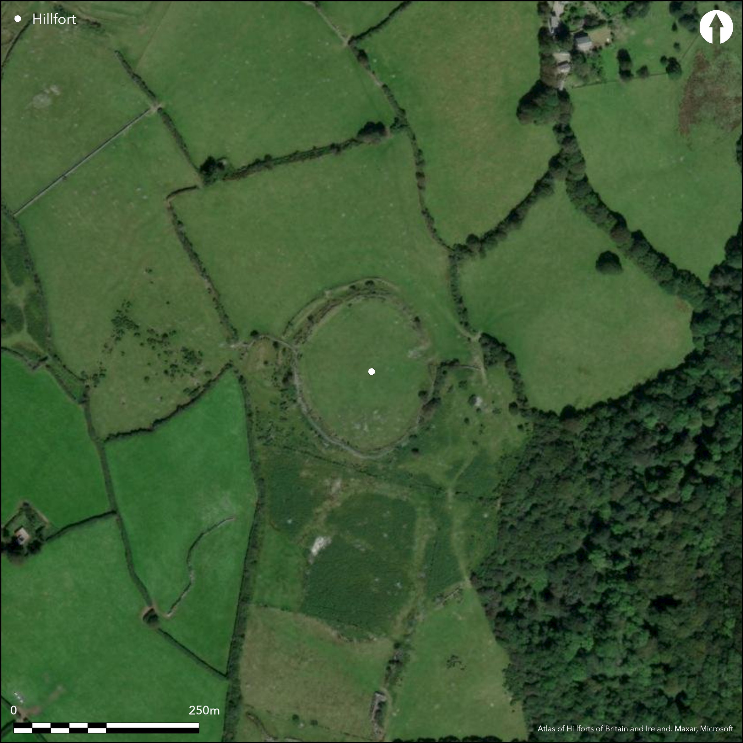
Oval and complex, 'multivallate', partial contour hillfort located just off crest of SE-facing hill NE of Cardinham village. Oval in plan, c. 188m N-S and 125m E-W. Inner, and principal, well-preserved rampart, to c. 3m high, topped by c. 0.6m high stone wall, with ditch averaging c. 1m deep, forms a univallate enclosure of c. 1.5ha. Strengthened on N side of fort, on level hilltop, and effectively cutting off approach, by two extra banks and ditches, the outer ploughed, terminating abruptly on W and E sides. The inner of these two banks refashioned and now a c. 1.6m - 2.0m high stone-revetted bank with slight outer ditch, seemingly joined to site by another rampart to form an annexe, possibly indicating phasing to site. The outer bank lies in an occasionally ploughed pasture field, rampart and ditch still traceable at 0.5m high and 0.3m deep respectively. Two 0.5m deep ditches wind down the hill on W side, but these are probably hollow ways from Little Bury farmstead. NE entrance now extensively mutilated, probably inturned, and is protected by two outer banks, also mutilated. Interior sloping to SE has numerous large granite boulders spread over its S half, but none form any identifiable pattern. W side of the hill fort covered by dense vegetation; the terminals of the two outer works here have clearly been disturbed at some period and the exact nature and purpose of two 0.9m high oval mounds are difficult to ascertain. Dense scrub on part. No excavations to this disturbed, but generally well-preserved site. On 1st Ed. OS map (1882). Undated.
Citizen Science: ✗
Reliability of Data: Confirmed
Reliability of Interpretation: Confirmed
X: -515476 Y: 6532720 (EPSG: 3857)
Longitude: -4.630602466168921 Latitude: 50.49656238472823 (EPSG:4326)
Country: England
Current County or Unitary Authority: Cornwall
Historic County: Cornwall
Current Parish/Community/Council/Townland: Cardinham
Damaged in part; especially entrance, but elsewhere generally well preserved. West side scrub covered. Second outer rampart to N lies in pasture, occasionally ploughed, and with the bank spread. Numerous large granite boulders spread over S half of interior.
| Extant | ✓ |
| Cropmark | ✗ |
| Likely Destroyed | ✗ |
W side of the hillfort covered by dense scrub vegetation.
| Woodland | ✗ |
| Commercial Forestry Plantation | ✗ |
| Parkland | ✗ |
| Pasture (Grazing) | ✓ |
| Arable | ✓ |
| Scrub/Bracken | ✓ |
| Bare Outcrop | ✗ |
| Heather/Moorland | ✗ |
| Heath | ✗ |
| Built-up | ✗ |
| Coastal Grassland | ✗ |
| Other | ✗ |
Oval and complex 'multivallate' hillfort located just off crest of SE-facing hill NE of Cardinham village.
| Contour Fort | ✗ |
| Partial Contour Fort | ✓ |
| Promontory Fort | ✗ |
| Hillslope Fort | ✗ |
| Level Terrain Fort | ✗ |
| Marsh Fort | ✗ |
| Multiple Enclosure Fort | ✗ |
Located just off the crest of a south-facing, gently sloping hillside
| Hilltop | ✓ |
| Coastal Promontory | ✗ |
| Inland Promontory | ✗ |
| Valley Bottom | ✗ |
| Knoll/Hillock/Outcrop | ✗ |
| Ridge | ✗ |
| Cliff/Plateau-edge/Scarp | ✗ |
| Hillslope | ✓ |
| Lowland | ✗ |
| Spur | ✗ |
Dominant Topographic Feature: SE-facing hill.
| North | ✗ |
| Northeast | ✗ |
| East | ✗ |
| Southeast | ✓ |
| South | ✗ |
| Southwest | ✗ |
| West | ✗ |
| Northwest | ✗ |
| Level | ✗ |
Altitude: 253.0m
N/A
None
Reliability: D - None
| Pre 1200BC | ✗ |
| 1200BC - 800BC | ✗ |
| 800BC - 400BC | ✗ |
| 400BC - AD50 | ✗ |
| AD50 - AD400 | ✗ |
| AD400 - AD 800 | ✗ |
| Post AD800 | ✗ |
| Unknown | ✓ |
| Pre Hillfort: | None |
| Post Hillfort: | None |
Shown on 1st ed. 1" OS map 1813. On 1st Ed. OS map (1882). Field investigation Ordnance Survey 1973. RCHME Measured Survey 1978.
| 1st Identified Map Depiction (1813): | OS Ist ed. 1' map. |
| Other (1882): | OS map |
| Other (1973): | Field investigation OS. |
| Earthwork Survey (1978): | RCHME Measured Survey. |
None
None
| None | ✓ |
| Spring | ✗ |
| Stream | ✗ |
| Pool | ✗ |
| Flush | ✗ |
| Well | ✗ |
| Other | ✗ |
None
| No Known Features | ✓ |
| Round Stone Structures | ✗ |
| Rectangular Stone Structures | ✗ |
| Curvilinear Platforms | ✗ |
| Other Roundhouse Evidence | ✗ |
| Pits | ✗ |
| Quarry Hollows | ✗ |
| Other | ✗ |
None
| No Known Excavation | ✓ |
| Pits | ✗ |
| Postholes | ✗ |
| Roundhouses | ✗ |
| Rectangular Structures | ✗ |
| Roads/Tracks | ✗ |
| Quarry Hollows | ✗ |
| Other | ✗ |
| Nothing Found | ✗ |
None
| No Known Geophysics | ✓ |
| Pits | ✗ |
| Roundhouses | ✗ |
| Rectangular Structures | ✗ |
| Roads/Tracks | ✗ |
| Quarry Hollows | ✗ |
| Other | ✗ |
| Nothing Found | ✗ |
None
| No Known Finds | ✓ |
| Pottery | ✗ |
| Metal | ✗ |
| Metalworking | ✗ |
| Human Bones | ✗ |
| Animal Bones | ✗ |
| Lithics | ✗ |
| Environmental | ✗ |
| Other | ✗ |
None
| APs Not Checked | ✓ |
| None | ✗ |
| Roundhouses | ✗ |
| Rectangular Structures | ✗ |
| Pits | ✗ |
| Postholes | ✗ |
| Roads/Tracks | ✗ |
| Other | ✗ |
NE entrance now extensively mutilated. Probably inturned and is protected by two outer banks, also mutilated.
| 1: | None |
| 2: | None |
Guard Chambers: ✗
Chevaux de Frise: ✗
| 1. In-turned (North east): | Mutilated. |
| 1. Outworks (North east): | Protected by two outer banks, also mutilated. |
Inner, and principal, well-preserved rampart, to c. 3m high, topped by c. 0.6m high stone wall, with ditch averaging c. 1m deep, forms an enclosure of c. 1.5ha. Strengthened on N side of fort, on the level hilltop,and effectively cutting off the approach, by two extra banks and ditches, the outer ploughed, terminating abruptly on W and E sides. The inner of these two banks has been refashioned and now a c. 1.6m - 2.0m high stone-revetted bank with slight outer ditch, seemingly joined to the site by another rampart to form an annexe. The outer bank lies in an occasionally ploughed pasture field, the rampart and ditch still traceable at 0.5m high and 0.3m deep respectively. Two 0.5m deep ditches wind down the hill on the W side, but these are probably hollow-ways from Little Bury farmstead.
| Area 1: | 1.5ha. |
| Total: | 1.5ha. |
Total Footprint Area: Noneha.
None
| ✓ | Possibly phased construction. |
| ✓ | Only main inner bank defined in quadrants, as inner of two outer banks possibly suggestive of annexe, with an additional outer bank. |
| NE Quadrant: | 3 |
| SE Quadrant: | 1 |
| SW Quadrant: | 1 |
| NW Quadrant: | 3 |
| Total: | 3 |
| Partial Univallate | ✓ |
| Univallate | ✗ |
| Partial Bivallate | ✗ |
| Bivallate | ✗ |
| Partial Multivallate | ✓ |
| Multivallate | ✗ |
| Unknown | ✗ |
| Partial Univallate | ✗ |
| Univallate | ✓ |
| Partial Bivallate | ✗ |
| Bivallate | ✗ |
| Partial Multivallate | ✗ |
| Multivallate | ✗ |
Stone revetment in evidence.
| None | ✗ |
| Earthen Bank | ✓ |
| Stone Wall | ✓ |
| Rubble | ✓ |
| Wall-walk | ✗ |
| Evidence of Timber | ✗ |
| Vitrification | ✗ |
| Other Burning | ✗ |
| Palisade | ✗ |
| Counter Scarp Bank | ✗ |
| Berm | ✗ |
| Unfinished | ✗ |
| Other | ✗ |
None
| None | ✗ |
| Earthen Bank | ✗ |
| Stone Wall | ✗ |
| Murus Duplex | ✗ |
| Timber-framed | ✗ |
| Timber-laced | ✗ |
| Vitrification | ✗ |
| Other Burning | ✗ |
| Palisade | ✗ |
| Counter Scarp Bank | ✗ |
| Berm | ✗ |
| Unfinished | ✗ |
| No Known Excavation | ✓ |
| Other | ✗ |
| ✗ | None |
| ✓ | None |
Number of Ditches: 3
| ✓ | Fort strengthened on N side on the level hilltop, and effectively cutting off the approach, by two extra banks and ditches, the outer ploughed, terminating abruptly on W and E sides. The inner of these two banks has been refashioned at some stage and is now a c. 1.6m - 2.0m high stone-revetted bank with slight outer ditch, seemingly joined to the site by another rampart to form an annexe. |
Johnson, N. and Rose, P. 1994. Bodmin Moor; an archaeological survey, Vol I, 48, Fig 32, RCHME Suppl Rept II.
Page, W. ed. 1906. The Victoria History of the County of Cornwall, 1, London: James Street, 463.
Atlas of Hillforts:
Wikidata:
This work is licensed under CC BY-SA 4.0![]()
![]()
![]() and should be cited as:
and should be cited as:
Lock, Gary and Ralston, Ian. 2024. Atlas of Hillforts of Britain and Ireland. Available at: https://hillforts.arch.ox.ac.uk
Document Version 1.1