LiDAR 1m DTM Hillshade
Satellite Imagery
LiDAR 1m DTM Hillshade
Satellite Imagery
Scroll left/right to view further images.
HER: Cornwall and Scilly MCO34 (6865)
NMR: SX 36 NW 5 (436704)
SM: 1004494
NGR: SX3433067385
X: 234330 Y: 67385 (OSGB36)
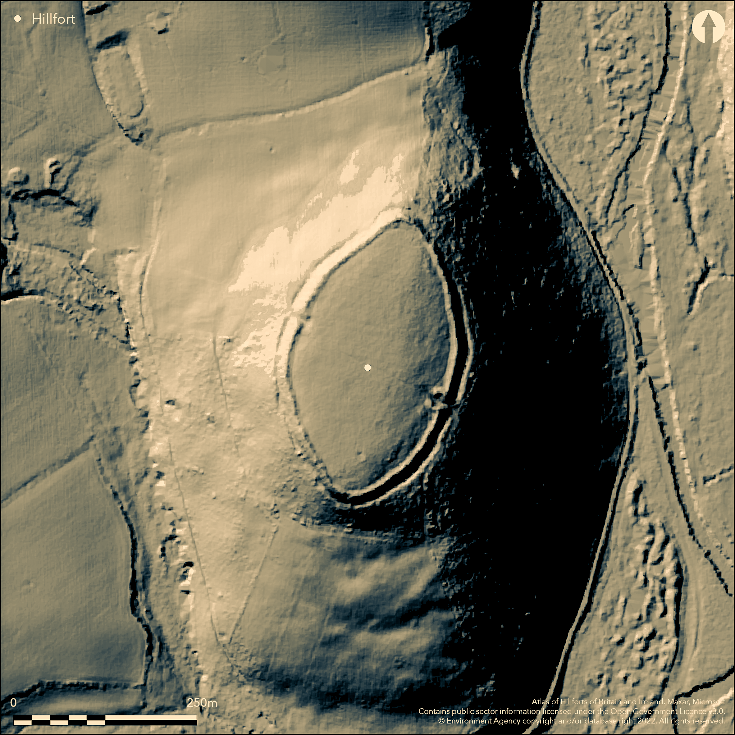
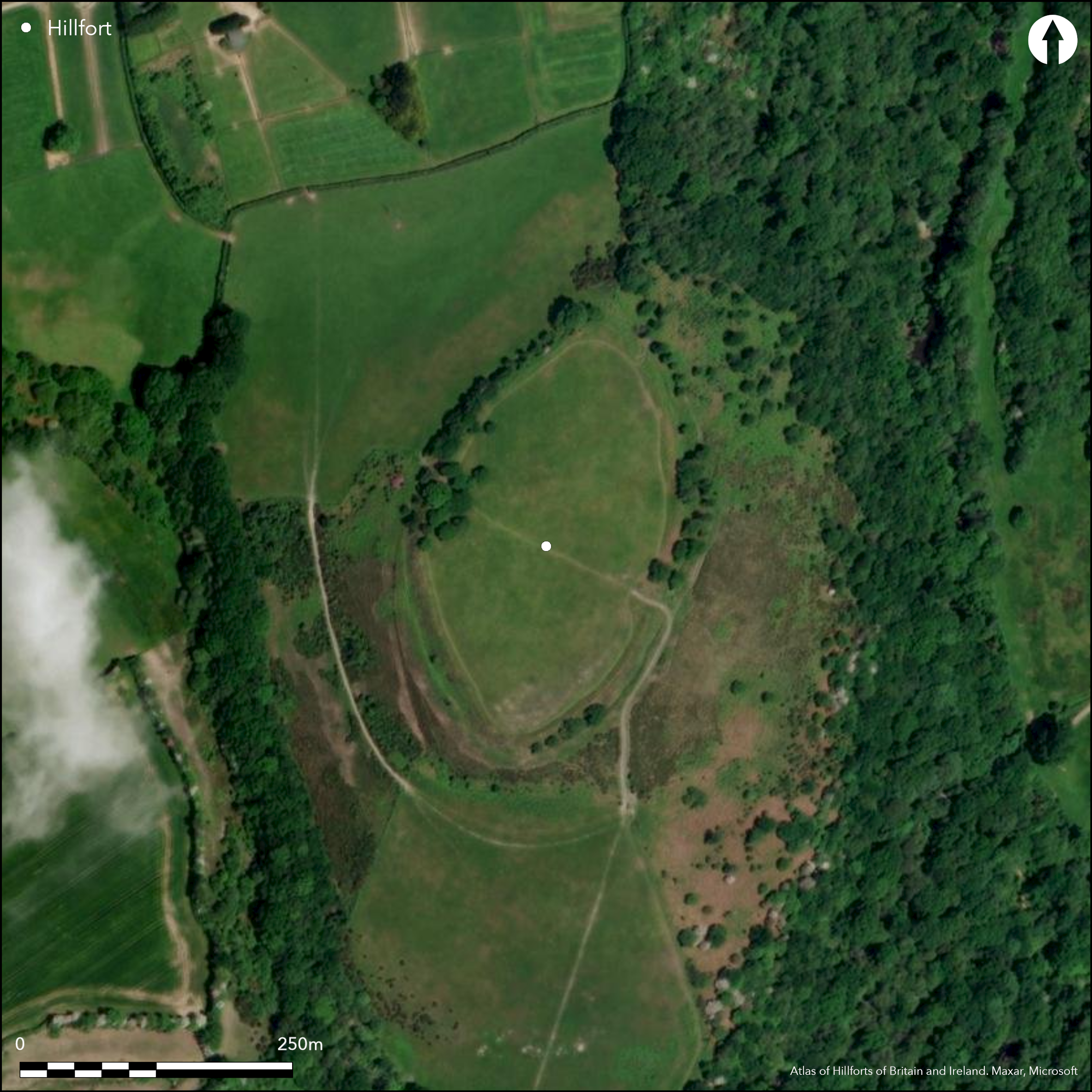
Univallate, egg-shaped, contour hillfort sited in a commanding position above River Lynher to E, on and enclosing summit of hill called Cadson Bury Down near Callington. Very steep surrounding slopes to E, steep to S and W and moderate to steep to N where ridge. Rampart follows 94m contour. Dimensions c. 255m N-S by 145m E-W, encloses 2.53ha. Bank rises to c. 4.5m high on its outside with outer ditch up to 1.5m wide and to 1.3m deep to the S, but this gives way to a berm on N half. Two well-preserved original inturned entrances to the SE and (possibly) NW. A staggered S breach may also be original and cut through by footpath. Chance find of a spindle whorl on SE slope. 'Cadsonbury' was first recorded in the 13th century, and its earliest depiction was on Martyn's map of 1748. It was described by D. and S. Lysons in 1814. Interior largely level and scrub covered. Well-preserved National Trust property. On 1st Ed. OS map (1882-83).
Citizen Science: ✗
Reliability of Data: Confirmed
Reliability of Interpretation: Confirmed
X: -482749 Y: 6530301 (EPSG: 3857)
Longitude: -4.336607570335468 Latitude: 50.48273520681156 (EPSG:4326)
Country: England; None
Current County or Unitary Authority: Cornwall
Historic County: Cornwall
Current Parish/Community/Council/Townland: St Ives; St. Mellion
Well-preserved National Trust property. On Heritage at Risk Register (2015).
| Extant | ✓ |
| Cropmark | ✗ |
| Likely Destroyed | ✗ |
Scrub covered to SE and formerly ploughed and seeded. Wooded E slopes to river.
| Woodland | ✗ |
| Commercial Forestry Plantation | ✗ |
| Parkland | ✗ |
| Pasture (Grazing) | ✓ |
| Arable | ✗ |
| Scrub/Bracken | ✓ |
| Bare Outcrop | ✗ |
| Heather/Moorland | ✗ |
| Heath | ✗ |
| Built-up | ✗ |
| Coastal Grassland | ✗ |
| Other | ✗ |
Univallate, egg-shaped, contour hillfort sited in commanding position above River Lynher to E, on and enclosing summit of hill called Cadson Bury Down near Callington. Very steep surrounding slopes to E, steep to S and W and moderate to steep to N where ridge.
| Contour Fort | ✓ |
| Partial Contour Fort | ✗ |
| Promontory Fort | ✗ |
| Hillslope Fort | ✗ |
| Level Terrain Fort | ✗ |
| Marsh Fort | ✗ |
| Multiple Enclosure Fort | ✗ |
Steep sided hilltop which roughly follows the 91m contour
| Hilltop | ✓ |
| Coastal Promontory | ✗ |
| Inland Promontory | ✗ |
| Valley Bottom | ✗ |
| Knoll/Hillock/Outcrop | ✗ |
| Ridge | ✗ |
| Cliff/Plateau-edge/Scarp | ✗ |
| Hillslope | ✗ |
| Lowland | ✗ |
| Spur | ✗ |
Dominant Topographic Feature: Hill top
| North | ✗ |
| Northeast | ✗ |
| East | ✗ |
| Southeast | ✗ |
| South | ✗ |
| Southwest | ✗ |
| West | ✗ |
| Northwest | ✗ |
| Level | ✓ |
Altitude: 94.0m
Parish boundary with St. Mellion 100m to E
Boundary Type: Parish/Townland
None
Reliability: D - None
| Pre 1200BC | ✗ |
| 1200BC - 800BC | ✗ |
| 800BC - 400BC | ✗ |
| 400BC - AD50 | ✗ |
| AD50 - AD400 | ✗ |
| AD400 - AD 800 | ✗ |
| Post AD800 | ✗ |
| Unknown | ✓ |
| Pre Hillfort: | None |
| Post Hillfort: | None |
'Cadsonbury' first recorded 1262. Earliest depiction on Martyn's map of 1748 and described by Lysons in 1814. On 1st Ed. OS map (1882-83). Historic Landscape Chacterisation Survey - Management Survey Lynher Valley, Cornwall County Council 2000.
| 1st Identified Written Reference (1262): | 'Cadsonbury' first recorded - no details. |
| 1st Identified Map Depiction (1748): | Martyn's map. |
| Other (1814): | D. Lysons and S. Lysons description. |
| Other (2000): | Historic Landscape Chacterisation Survey - Management Survey Lynher Valley, Cornwall County Council. |
| Other (None): | OS map. |
Chance find of an (undefined) spindle whorl on SE slope.
None
| None | ✓ |
| Spring | ✗ |
| Stream | ✗ |
| Pool | ✗ |
| Flush | ✗ |
| Well | ✗ |
| Other | ✗ |
None
| No Known Features | ✓ |
| Round Stone Structures | ✗ |
| Rectangular Stone Structures | ✗ |
| Curvilinear Platforms | ✗ |
| Other Roundhouse Evidence | ✗ |
| Pits | ✗ |
| Quarry Hollows | ✗ |
| Other | ✗ |
None
| No Known Excavation | ✓ |
| Pits | ✗ |
| Postholes | ✗ |
| Roundhouses | ✗ |
| Rectangular Structures | ✗ |
| Roads/Tracks | ✗ |
| Quarry Hollows | ✗ |
| Other | ✗ |
| Nothing Found | ✗ |
None
| No Known Geophysics | ✓ |
| Pits | ✗ |
| Roundhouses | ✗ |
| Rectangular Structures | ✗ |
| Roads/Tracks | ✗ |
| Quarry Hollows | ✗ |
| Other | ✗ |
| Nothing Found | ✗ |
Chance find of an (undefined) spindle whorl on SE slope.
| No Known Finds | ✗ |
| Pottery | ✗ |
| Metal | ✗ |
| Metalworking | ✗ |
| Human Bones | ✗ |
| Animal Bones | ✗ |
| Lithics | ✗ |
| Environmental | ✗ |
| Other | ✓ |
None
| APs Not Checked | ✓ |
| None | ✗ |
| Roundhouses | ✗ |
| Rectangular Structures | ✗ |
| Pits | ✗ |
| Postholes | ✗ |
| Roads/Tracks | ✗ |
| Other | ✗ |
Two well-preserved original inturned entrances to SE and (possibly) NW. Staggered S breach may also be original.
| 4: | None |
| 2: | NW and S breach uncertain. |
Guard Chambers: ✗
Chevaux de Frise: ✗
| 1. In-turned (South east): | None |
| 2. In-turned (North west): | Possibly original entrance. |
| 3. Over-lapping (South): | Staggered entrance possibly original and cut through by footpath. |
| 4. In-turned (South east): | None |
Rampart follows the 94m contour. Dimensions c. 255m N-S and 145m E-W. Bank rises to c. 4.5m high on its outside with an outer ditch up to 1.5m wide and to 1.3m deep to the S, but this gives way to a berm on N half.
| Area 1: | 2.53ha. |
| Total: | 2.53ha. |
Total Footprint Area: Noneha.
None
| ✗ | None |
| ✓ | None |
| NE Quadrant: | 1 |
| SE Quadrant: | 1 |
| SW Quadrant: | 1 |
| NW Quadrant: | 1 |
| Total: | 1 |
| Partial Univallate | ✗ |
| Univallate | ✓ |
| Partial Bivallate | ✗ |
| Bivallate | ✗ |
| Partial Multivallate | ✗ |
| Multivallate | ✗ |
| Unknown | ✗ |
| Partial Univallate | ✗ |
| Univallate | ✗ |
| Partial Bivallate | ✗ |
| Bivallate | ✗ |
| Partial Multivallate | ✗ |
| Multivallate | ✗ |
Berm on N half.
| None | ✗ |
| Earthen Bank | ✓ |
| Stone Wall | ✗ |
| Rubble | ✗ |
| Wall-walk | ✗ |
| Evidence of Timber | ✗ |
| Vitrification | ✗ |
| Other Burning | ✗ |
| Palisade | ✗ |
| Counter Scarp Bank | ✗ |
| Berm | ✓ |
| Unfinished | ✗ |
| Other | ✗ |
None
| None | ✗ |
| Earthen Bank | ✗ |
| Stone Wall | ✗ |
| Murus Duplex | ✗ |
| Timber-framed | ✗ |
| Timber-laced | ✗ |
| Vitrification | ✗ |
| Other Burning | ✗ |
| Palisade | ✗ |
| Counter Scarp Bank | ✗ |
| Berm | ✗ |
| Unfinished | ✗ |
| No Known Excavation | ✓ |
| Other | ✗ |
| ✗ | None |
| ✓ | None |
Number of Ditches: 1
| ✗ | None |
Anon 2000-2001. Note, Archaeology Alive: a review of work by the Cornwall Archaeological Unit, CAU, 9, 2000-2001, Cornwall County Council.
Lysons, D. and Lysons, S. 1814. Magna Britannia. Vol 3, Cornwall.
Page, W. ed. 1906. The Victoria History of the County of Cornwall, 1, London: James Street, 469.
Atlas of Hillforts:
Wikidata:
This work is licensed under CC BY-SA 4.0![]()
![]()
![]() and should be cited as:
and should be cited as:
Lock, Gary and Ralston, Ian. 2024. Atlas of Hillforts of Britain and Ireland. Available at: https://hillforts.arch.ox.ac.uk
Document Version 1.1