LiDAR 1m DTM Hillshade
Satellite Imagery
LiDAR 1m DTM Hillshade
Satellite Imagery
Scroll left/right to view further images.
HER: Cornwall and Scilly MCO36 (19502)
NMR: SW 75 SE 12 (428225)
SM: 1016108
NGR: SW77755218
X: 177757 Y: 52188 (OSGB36)
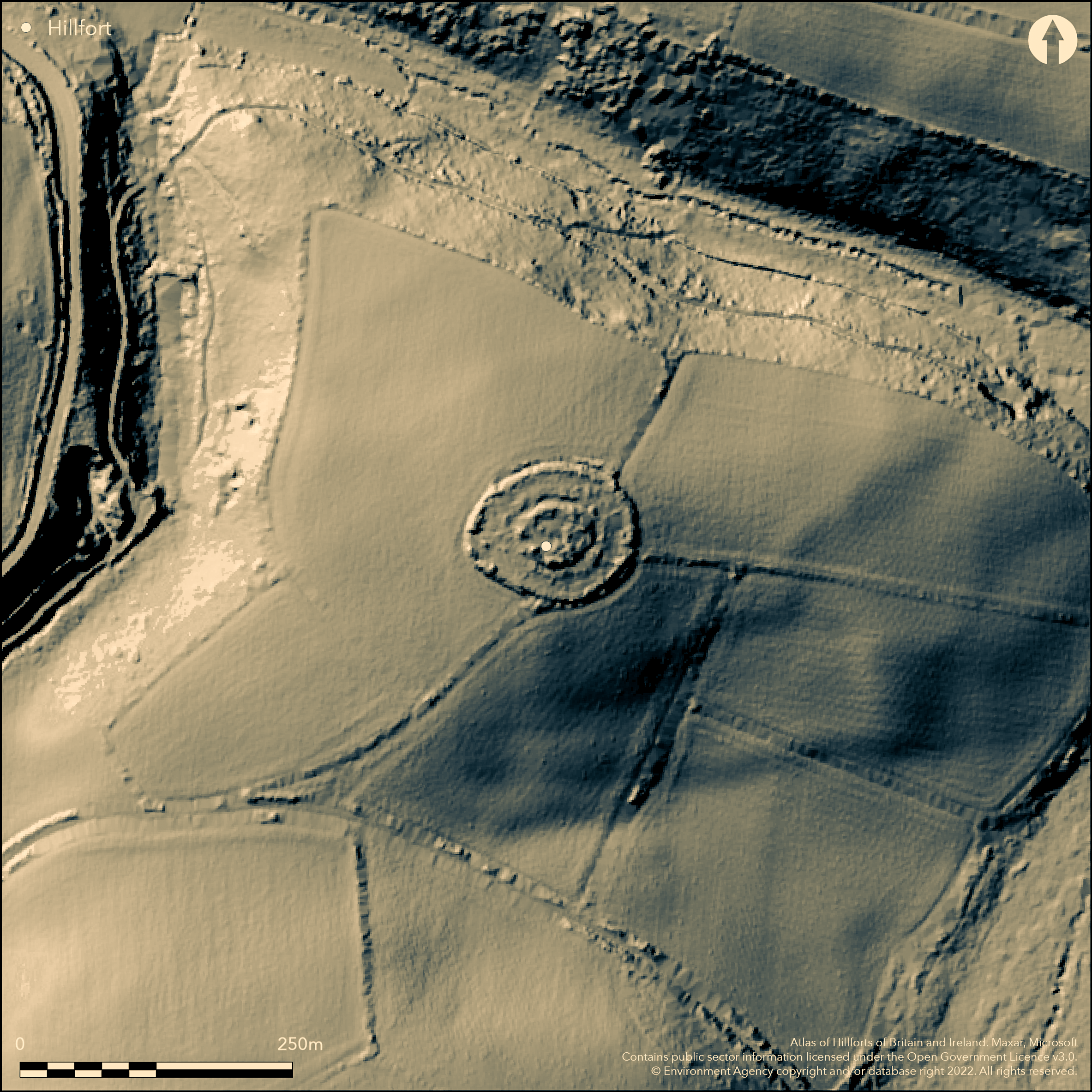
Multiple enclosure fort located on summit of hill 3.5km SE of Perranporth on the north Cornish coast. Surrounded on three of its four sides by small streams. Moderate then very steep and wooded slopes to N, moderate then steep to E, S, W. Across the valley to SW from Caer Kief enclosure. Roughly oval in shape with three complex concentric lines of defence. Inner circuit 40m E-W by 22m N-S, enclosing c. 0.3ha, on the highest ground with rampart 3.5m high surrounded by a ditch 4.9m wide. Middle line, surrounding central core at distances of between 22m and 26m, includes rampart 2m high fronted by ditch 3.9m wide, less visible on S. Counterscarp bank follows line of this ditch along part of N circuit. Near circular third concentric ditch, just visible as slight scarps on break of slope at distances of between 60m and 90m from inner circuit; this outwork has a diameter of 230m. Bank forming part of hedge on SW side, may also be part of these outer defences. E entrance and possible barrow in interior. E side joined by banked field system, possibly contemporary. Only fragments of ramparts now visible. Wooded inner circuit; pasture outside. On 1st Ed OS map (1880). Undated.
Citizen Science: ✗
Reliability of Data: Confirmed
Reliability of Interpretation: Confirmed
X: -570395 Y: 6503195 (EPSG: 3857)
Longitude: -5.12394439226511 Latitude: 50.32754281303044 (EPSG:4326)
Country: England
Current County or Unitary Authority: Cornwall
Historic County: Cornwall
Current Parish/Community/Council/Townland: Perranzabuloe
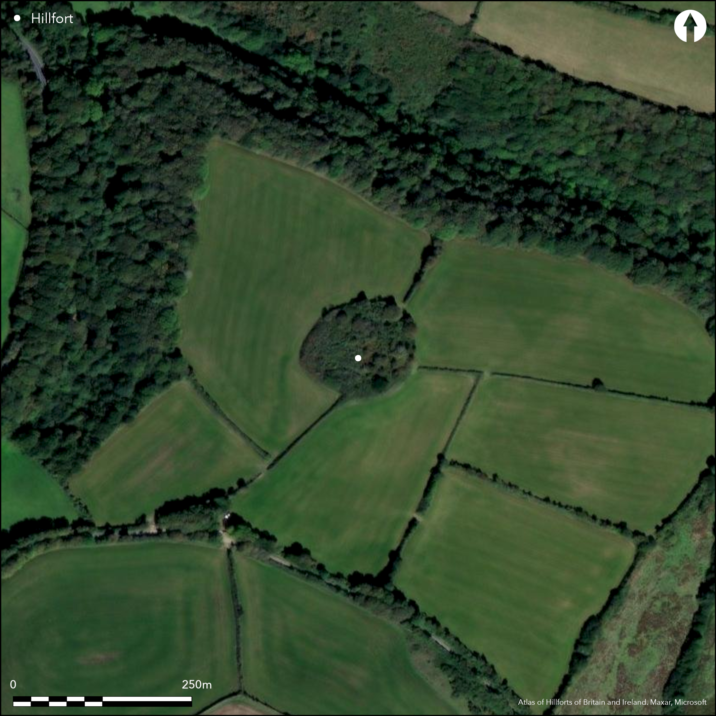
Only fragments of ramparts now visible.
| Extant | ✓ |
| Cropmark | ✗ |
| Likely Destroyed | ✗ |
Wooded inner circuit; pasture outside.
| Woodland | ✓ |
| Commercial Forestry Plantation | ✗ |
| Parkland | ✗ |
| Pasture (Grazing) | ✓ |
| Arable | ✗ |
| Scrub/Bracken | ✗ |
| Bare Outcrop | ✗ |
| Heather/Moorland | ✗ |
| Heath | ✗ |
| Built-up | ✗ |
| Coastal Grassland | ✗ |
| Other | ✗ |
Multiple enclosure fort located on summit of hill 3.5km SE of Perranporth on the north Cornish coast. Surrounded on three of its four sides by small streams. Moderate then very steep and wooded slopes to N, moderate then steep to E, S, W.
| Contour Fort | ✓ |
| Partial Contour Fort | ✗ |
| Promontory Fort | ✗ |
| Hillslope Fort | ✗ |
| Level Terrain Fort | ✗ |
| Marsh Fort | ✗ |
| Multiple Enclosure Fort | ✓ |
Hilltop site
| Hilltop | ✓ |
| Coastal Promontory | ✗ |
| Inland Promontory | ✗ |
| Valley Bottom | ✗ |
| Knoll/Hillock/Outcrop | ✗ |
| Ridge | ✗ |
| Cliff/Plateau-edge/Scarp | ✗ |
| Hillslope | ✗ |
| Lowland | ✗ |
| Spur | ✗ |
Dominant Topographic Feature: Hill top
| North | ✗ |
| Northeast | ✗ |
| East | ✗ |
| Southeast | ✗ |
| South | ✗ |
| Southwest | ✗ |
| West | ✗ |
| Northwest | ✗ |
| Level | ✓ |
Altitude: 70.0m
N/A
None.
Reliability: D - None
| Pre 1200BC | ✗ |
| 1200BC - 800BC | ✗ |
| 800BC - 400BC | ✗ |
| 400BC - AD50 | ✗ |
| AD50 - AD400 | ✗ |
| AD400 - AD 800 | ✗ |
| Post AD800 | ✗ |
| Unknown | ✓ |
| Pre Hillfort: | Possible barrow in interior. |
| Post Hillfort: | None |
Earliest record T. Tonkin 1710. On 1st Ed OS map (1880). Field investigation Ordnance Survey 1971.
| 1st Identified Written Reference (1710): | T. Tonkin. |
| 1st Identified Map Depiction (1880): | OS map. |
| Other (1971): | Field investigation OS. |
None.
None
| None | ✓ |
| Spring | ✗ |
| Stream | ✗ |
| Pool | ✗ |
| Flush | ✗ |
| Well | ✗ |
| Other | ✗ |
None
| No Known Features | ✓ |
| Round Stone Structures | ✗ |
| Rectangular Stone Structures | ✗ |
| Curvilinear Platforms | ✗ |
| Other Roundhouse Evidence | ✗ |
| Pits | ✗ |
| Quarry Hollows | ✗ |
| Other | ✗ |
None
| No Known Excavation | ✓ |
| Pits | ✗ |
| Postholes | ✗ |
| Roundhouses | ✗ |
| Rectangular Structures | ✗ |
| Roads/Tracks | ✗ |
| Quarry Hollows | ✗ |
| Other | ✗ |
| Nothing Found | ✗ |
None
| No Known Geophysics | ✓ |
| Pits | ✗ |
| Roundhouses | ✗ |
| Rectangular Structures | ✗ |
| Roads/Tracks | ✗ |
| Quarry Hollows | ✗ |
| Other | ✗ |
| Nothing Found | ✗ |
None
| No Known Finds | ✓ |
| Pottery | ✗ |
| Metal | ✗ |
| Metalworking | ✗ |
| Human Bones | ✗ |
| Animal Bones | ✗ |
| Lithics | ✗ |
| Environmental | ✗ |
| Other | ✗ |
None
| APs Not Checked | ✓ |
| None | ✗ |
| Roundhouses | ✗ |
| Rectangular Structures | ✗ |
| Pits | ✗ |
| Postholes | ✗ |
| Roads/Tracks | ✗ |
| Other | ✗ |
E entrance.
| 1: | None |
| 2: | None |
Guard Chambers: ✗
Chevaux de Frise: ✗
| 1. Simple Gap (East): | None |
Roughly oval in shape with three concentric lines of defence. Inner circuit 40m E-W by 22m N-S on the highest ground with rampart 3.5m high surrounded by a ditch 4.9m wide. Middle line, surrounding central core at distances of between 22m and 26m, includes a rampart 2m high fronted by a ditch 3.9m wide, less visible on S. Counterscarp bank follows the line of this ditch along part of N circuit. Near circular third concentric ditch, just visible as slight scarps on break of slope at distances of between 60m and 90m from inner circuit; this outwork has a diameter of 230m. Bank forming part of hedge on SW side, may also be part of these outer defences.
| Area 1: | 0.3ha. |
| Total: | 0.3ha. |
Total Footprint Area: Noneha.
None
| ✗ | None |
| ✓ | Counterscarp to middle circuit not included in quadrants. |
| NE Quadrant: | 3 |
| SE Quadrant: | 3 |
| SW Quadrant: | 3 |
| NW Quadrant: | 3 |
| Total: | 3 |
| Partial Univallate | ✗ |
| Univallate | ✗ |
| Partial Bivallate | ✗ |
| Bivallate | ✗ |
| Partial Multivallate | ✗ |
| Multivallate | ✓ |
| Unknown | ✗ |
| Partial Univallate | ✗ |
| Univallate | ✗ |
| Partial Bivallate | ✗ |
| Bivallate | ✗ |
| Partial Multivallate | ✗ |
| Multivallate | ✗ |
Counterscarp to middle circuit along part of N.
| None | ✗ |
| Earthen Bank | ✓ |
| Stone Wall | ✗ |
| Rubble | ✗ |
| Wall-walk | ✗ |
| Evidence of Timber | ✗ |
| Vitrification | ✗ |
| Other Burning | ✗ |
| Palisade | ✗ |
| Counter Scarp Bank | ✓ |
| Berm | ✗ |
| Unfinished | ✗ |
| Other | ✗ |
None
| None | ✗ |
| Earthen Bank | ✗ |
| Stone Wall | ✗ |
| Murus Duplex | ✗ |
| Timber-framed | ✗ |
| Timber-laced | ✗ |
| Vitrification | ✗ |
| Other Burning | ✗ |
| Palisade | ✗ |
| Counter Scarp Bank | ✗ |
| Berm | ✗ |
| Unfinished | ✗ |
| No Known Excavation | ✓ |
| Other | ✗ |
| ✗ | None |
| ✓ | None |
Number of Ditches: 3
| ✗ | None |
Gilbert, C.S. 1820. An historical and topographical survey of the County of Cornwall, Vol I, 206.
Lysons, D. and Lysons, S. 1814. Magna Britannia. Vol 3, Cornwall, 249.
MacLauchlan, H. 1847. Annual Report, J Royal Inst Cornwall, 29 (1847), 34.
Page, W. ed. 1906. The Victoria History of the County of Cornwall, 1, London: James Street, 462.
Tonkin, T. 1710. Parochial history of Cornwall, 460a.
Warner, R. 1963. Parish of Perranzabuloe, Cornish Archaeol, 2, 69.
Atlas of Hillforts:
Wikidata:
This work is licensed under CC BY-SA 4.0![]()
![]()
![]() and should be cited as:
and should be cited as:
Lock, Gary and Ralston, Ian. 2024. Atlas of Hillforts of Britain and Ireland. Available at: https://hillforts.arch.ox.ac.uk
Document Version 1.1