
LiDAR 1m DTM Hillshade
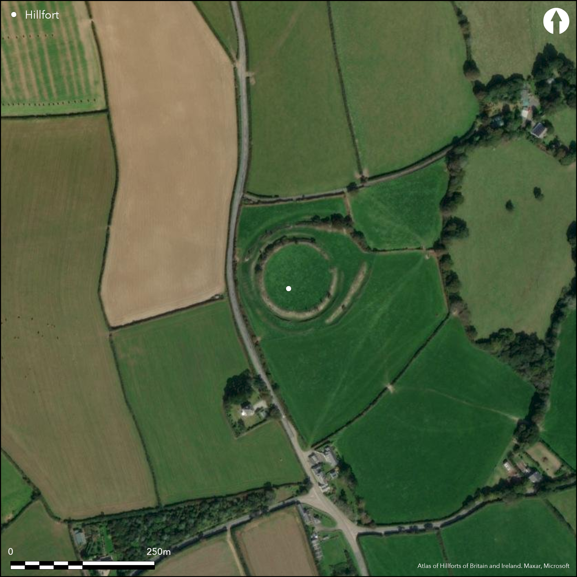
Satellite Imagery
LiDAR 1m DTM Hillshade
Satellite Imagery
Scroll left/right to view further images.
HER: Cornwall and Scilly MCO48/49 (26690)
NMR: SX 15 SW 1 (432238)
SM: 1006691
NGR: SX10345482
X: 210340 Y: 54820 (OSGB36)
Small, multivallate, partial contour hillfort, located on prominent ridge overlooking at least two tributaries of River Fowey. Steep surrounding slopes to E and W, ridge to N and S moderate. Circular interior area enclosing 0.5ha. Defined by good inner rampart and ditch with further, mainly concentric, outer rampart and part-buried outer ditch, diverging from inner rampart only on E to form more complex entrance annex. Mapped as three banks in 1847, no trace of third now. Glacis construction of ramparts. Interior partially excavated 1936 and 1937 by C.A. Raleigh-Radford. More recent reinterpretation of results suggests site constructed 5th-4th centuries BC based on ceramics. Later phase followed period of abandonment when entrance remodelled c. 4th-3rd centuries BC. Interior with four-to six-post structures (c. 20) and roundhouse remains, defined by post- holes with complex building sequence and frequent replacements of structures over long time. Two oval structures,possibly Romano-British or later occupation, but pottery assemblage suggests abandonment before Roman period. Finds included South-Western Decorated pottery and cordoned wares, late Iron Age bead, amphorae, Iron Age imported glass bracelets and a glass bead. Finds relating to skirmish between Charles I and Earl of Essex 1644 when Parliamentarian forces retreated into earthworks and held position until dark. Site in Arthurian legend. Plough damage to interior, trees and scrub on banks. On 1st Ed. OS map (1881-82).
Citizen Science: ✗
Reliability of Data: Confirmed
Reliability of Interpretation: Confirmed
X: -519644 Y: 6509307 (EPSG: 3857)
Longitude: -4.668042543106929 Latitude: 50.36258166327052 (EPSG:4326)
Country: England; None
Current County or Unitary Authority: Cornwall
Historic County: Cornwall
Current Parish/Community/Council/Townland: St Sampson; Tywardreath and Par
Plough damage to interior, trees and scrub on banks. Mapped as three banks in 1847, no trace of third now.
| Extant | ✓ |
| Cropmark | ✗ |
| Likely Destroyed | ✗ |
Trees, scrub and pasture.
| Woodland | ✓ |
| Commercial Forestry Plantation | ✗ |
| Parkland | ✗ |
| Pasture (Grazing) | ✓ |
| Arable | ✗ |
| Scrub/Bracken | ✓ |
| Bare Outcrop | ✗ |
| Heather/Moorland | ✗ |
| Heath | ✗ |
| Built-up | ✗ |
| Coastal Grassland | ✗ |
| Other | ✗ |
Small, multivallate, partial contour hillfort, located on prominent ridge overlooking at least two tributaries of River Fowey. Steep surrounding slopes to E and W, ridge to N and S moderate.
| Contour Fort | ✗ |
| Partial Contour Fort | ✓ |
| Promontory Fort | ✗ |
| Hillslope Fort | ✗ |
| Level Terrain Fort | ✗ |
| Marsh Fort | ✗ |
| Multiple Enclosure Fort | ✗ |
| Hilltop | ✗ |
| Coastal Promontory | ✗ |
| Inland Promontory | ✗ |
| Valley Bottom | ✗ |
| Knoll/Hillock/Outcrop | ✗ |
| Ridge | ✓ |
| Cliff/Plateau-edge/Scarp | ✗ |
| Hillslope | ✗ |
| Lowland | ✗ |
| Spur | ✗ |
Dominant Topographic Feature: Ridge
| North | ✗ |
| Northeast | ✗ |
| East | ✗ |
| Southeast | ✗ |
| South | ✗ |
| Southwest | ✗ |
| West | ✗ |
| Northwest | ✗ |
| Level | ✓ |
Altitude: 105.0m
Boundary Type: Parish/Townland
Interior partially excavated 1936 and 1937 by C.A. Raleigh-Radford. More recent reinterpretation of results suggests site constructed 5th-4th centuries BC based on ceramics. Later phase followed period of abandonment when entrance remodelled c. 4th-3rd centuries BC. Finds included middle Iron Age South-Western Decorated pottery, Glastonbury ware possibly to late Iron Age, late Iron Age bead and amphora, middle Iron Age imported glass bracelets and a glass bead. Two oval structures possibly Romano-British or later occupation, but pottery assemblage suggests abandonment before Roman period.
Reliability: B - Medium
| Pre 1200BC | ✗ |
| 1200BC - 800BC | ✗ |
| 800BC - 400BC | ✓ |
| 400BC - AD50 | ✓ |
| AD50 - AD400 | ✗ |
| AD400 - AD 800 | ✗ |
| Post AD800 | ✗ |
| Unknown | ✗ |
| Pre Hillfort: | None |
| Post Hillfort: | None |
| Artefactual: | Middle and late Iron Age finds. |
First mentioned by William Worcester in 1470. Mapped by H. MacLauchlan as three banks in 1847, no trace of third now. On 1st Ed. OS map (1881-82). Excavated 1936 and 1937 by C.A. Raleigh-Radford.
| 1st Identified Written Reference (1470): | First mentioned by William Worcester. |
| 1st Identified Map Depiction (1847): | Mapped by H. MacLaughlan. |
| Other (None): | OS map. |
| Excavation (None): | Interior part-excavation by C.A. Raleigh-Radford. |
Interior contained four-to six-post structures (c. 20) and roundhouse remains, defined by postholes indicating complex building sequence with frequent replacements of structures over a prolonged period. Two oval structures possibly Romano-British or later occupation, although pottery assemblage suggests abandonment before Roman period. South-Western decorated pottery and cordoned wares, late Iron Age bead and amphorae found. Iron Age imported glass bracelets and a glass bead.
None
| None | ✓ |
| Spring | ✗ |
| Stream | ✗ |
| Pool | ✗ |
| Flush | ✗ |
| Well | ✗ |
| Other | ✗ |
None
| No Known Features | ✓ |
| Round Stone Structures | ✗ |
| Rectangular Stone Structures | ✗ |
| Curvilinear Platforms | ✗ |
| Other Roundhouse Evidence | ✗ |
| Pits | ✗ |
| Quarry Hollows | ✗ |
| Other | ✗ |
Interior contained c. 20 four- to six-post structures and round houses remains, defined by post holes indicating complex building sequence with frequent replacements of structures over a prolonged period. Two oval structures possibly Romano-British or later occupation, although pottery assemblage suggests abandonment before Roman period.
| No Known Excavation | ✗ |
| Pits | ✗ |
| Postholes | ✓ |
| Roundhouses | ✓ |
| Rectangular Structures | ✓ |
| Roads/Tracks | ✗ |
| Quarry Hollows | ✗ |
| Other | ✓ |
| Nothing Found | ✗ |
None
| No Known Geophysics | ✓ |
| Pits | ✗ |
| Roundhouses | ✗ |
| Rectangular Structures | ✗ |
| Roads/Tracks | ✗ |
| Quarry Hollows | ✗ |
| Other | ✗ |
| Nothing Found | ✗ |
South-Western Decorated pottery and cordoned wares, late Iron Age bead and amphora found. Iron Age imported glass bracelets and a glass bead.
| No Known Finds | ✗ |
| Pottery | ✓ |
| Metal | ✗ |
| Metalworking | ✗ |
| Human Bones | ✗ |
| Animal Bones | ✗ |
| Lithics | ✗ |
| Environmental | ✗ |
| Other | ✓ |
None
| APs Not Checked | ✓ |
| None | ✗ |
| Roundhouses | ✗ |
| Rectangular Structures | ✗ |
| Pits | ✗ |
| Postholes | ✗ |
| Roads/Tracks | ✗ |
| Other | ✗ |
E entrance (inner and outer), the inner re-designed with inturn, roadway linking the two. Many modern gaps in circuit.
| 1: | One major gap, but also many modern gaps in circuit not defined. |
| 2: | None |
Guard Chambers: ✗
Chevaux de Frise: ✗
| 1. In-turned (East): | None |
Circular interior area has good inner rampart and ditch with further, mainly concentric, outer rampart and part-buried outer ditch, which diverge from inner rampart only on E to form more complex entrance annexe. Glacis construction of ramparts.
| Area 1: | 0.5ha. |
| Total: | 0.5ha. |
Total Footprint Area: Noneha.
None
| ✓ | Phased construction now re-interpretation of earlier results, suggesting site constructed 5th - 4th centuries BC based on ceramics. Later phase followed period of abandonment when entrance remodelled c. 4th-3rd centuries BC. Whether earlier univallate or bivallate uncertain. |
| ✓ | None |
| NE Quadrant: | 2 |
| SE Quadrant: | 2 |
| SW Quadrant: | 2 |
| NW Quadrant: | 2 |
| Total: | 2 |
| Partial Univallate | ✗ |
| Univallate | ✗ |
| Partial Bivallate | ✗ |
| Bivallate | ✓ |
| Partial Multivallate | ✗ |
| Multivallate | ✗ |
| Unknown | ✗ |
| Partial Univallate | ✗ |
| Univallate | ✗ |
| Partial Bivallate | ✗ |
| Bivallate | ✗ |
| Partial Multivallate | ✗ |
| Multivallate | ✗ |
Glacis construction of ramparts.
| None | ✗ |
| Earthen Bank | ✓ |
| Stone Wall | ✗ |
| Rubble | ✗ |
| Wall-walk | ✗ |
| Evidence of Timber | ✗ |
| Vitrification | ✗ |
| Other Burning | ✗ |
| Palisade | ✗ |
| Counter Scarp Bank | ✗ |
| Berm | ✗ |
| Unfinished | ✗ |
| Other | ✗ |
None
| None | ✗ |
| Earthen Bank | ✗ |
| Stone Wall | ✗ |
| Murus Duplex | ✗ |
| Timber-framed | ✗ |
| Timber-laced | ✗ |
| Vitrification | ✗ |
| Other Burning | ✗ |
| Palisade | ✗ |
| Counter Scarp Bank | ✗ |
| Berm | ✗ |
| Unfinished | ✗ |
| No Known Excavation | ✓ |
| Other | ✗ |
| ✗ | None |
| ✓ | None |
Number of Ditches: 2
| ✗ | None |
Fitzpatrick, A.P. 1985. The Iron Age bracelets from Castle Dore, Cornish Archaeol, 24, 133-140.
Henderson, J. 1985. The glass from Castle Dore: archaeological and chemical significance, Cornish Archaeol, 24, 141-47.
Quinell, H. 1986. Cornwall during the Iron Age and the Roman period, Cornish Archaeol, 25, 111-34.
Quinnell, H. and Harris, D. 1985. Castle Dore; the chronology reconsidered, Cornish Archaeol, 24, 123-132.
Rahtz, P. 1971. Castle Dore - a reappraisal of the post-Roman structures, Cornish Archaeol, 10, 49-54.
Ralegh Radford, C.A. 1951. Report on the excavations at Castle Dore, J Royal Inst Cornwall, 1, 1-11.
Atlas of Hillforts:
Wikidata:
This work is licensed under CC BY-SA 4.0![]()
![]()
![]() and should be cited as:
and should be cited as:
Lock, Gary and Ralston, Ian. 2024. Atlas of Hillforts of Britain and Ireland. Available at: https://hillforts.arch.ox.ac.uk
Document Version 1.1