LiDAR 1m DTM Hillshade
Satellite Imagery
LiDAR 1m DTM Hillshade
Satellite Imagery
Scroll left/right to view further images.
HER: Cornwall and Scilly MCO54 (30514)
NMR: SW 43 SW 30 (424235)
SM: 1007264
NGR: SW4050733943
X: 140507 Y: 33943 (OSGB36)
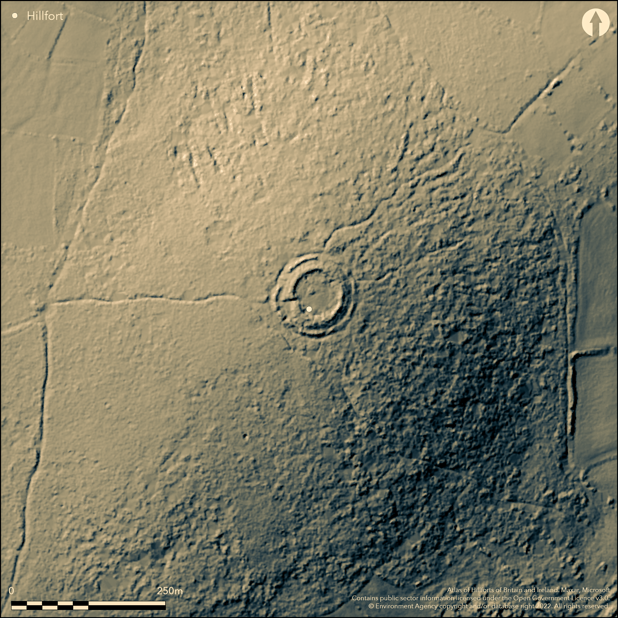
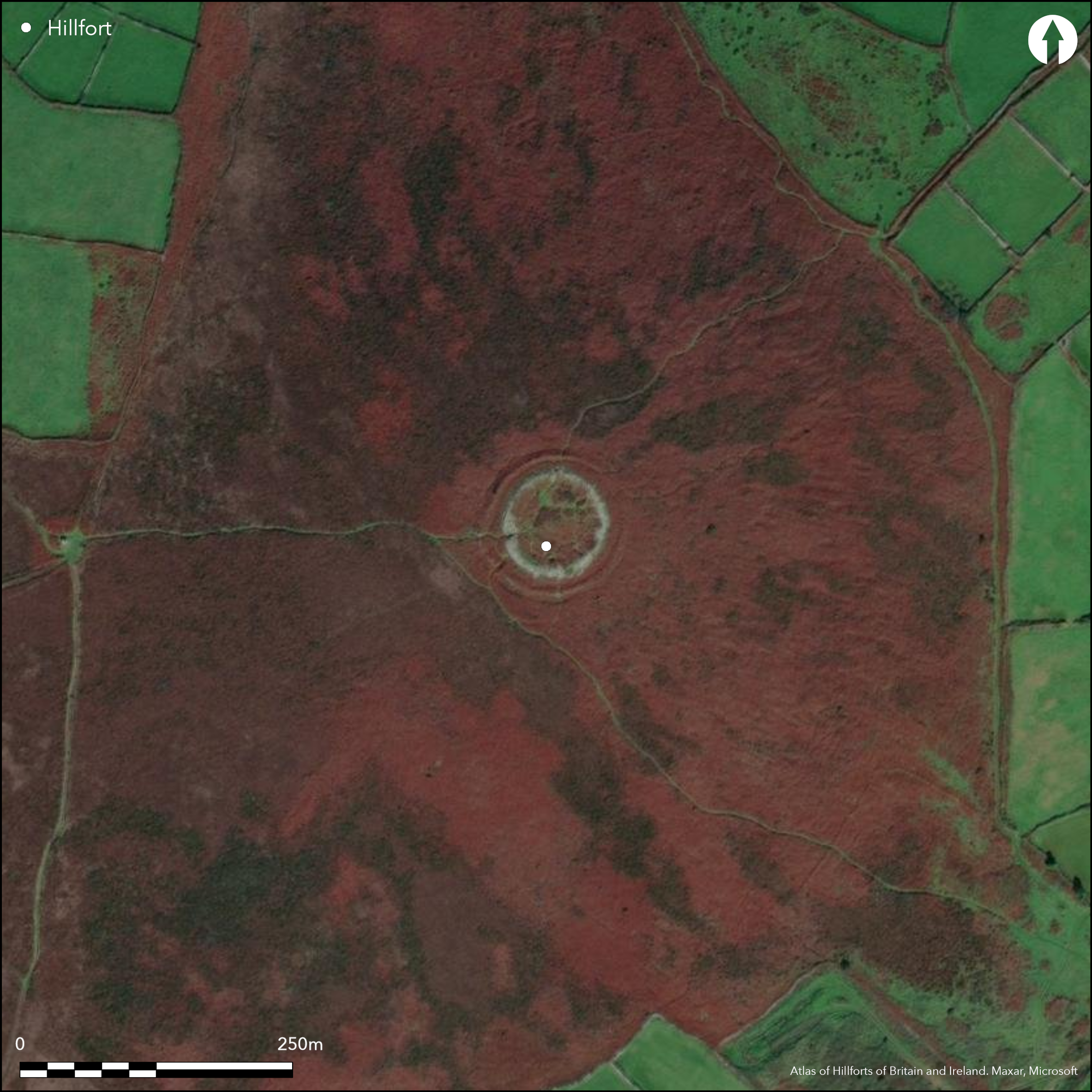
Bivallate, walled, partial contour hillfort sited on summit of Chun Downs. Steep surrounding slopes to N, E, SE, moderate on W. Forms part of complex of features, including the Chun Cromlech and barrow. Roughly circular encloses 0.14ha. Outer and inner walls tumbled and now c. 1.7m. and c. 1m high respectively, both with external ditch, inner not really visible, but walling remains intact at inner and outer SW entrances to 2.2m high overlooking Chun Quoit. Small curved bank and ditch 28 paces WNW of entrance, but this could be modern. Well recorded in NNW corner. Excavated in 1895, 1925, 1927 and 1930. Thought interior divided into ring of buildings with large furnace, around open space, but very little of walls remain. 1925 excavation found this large furnace in N of enclosure with 3.7m deep well in NNW, cleared out c. 25 years previously, house of elliptical form E of well and another in SE quadrant with two chambers. Finds included pottery, muller, slingstones, flint chips, 3 spindle whorls, a portion of shale bracelet, iron and tin slag. Long occupation. 1927 and 1930 excavations proved that the septa, first shown on Borlase's 18th century plan, and still extant, later than castle and may be cattle pens of date unknown. Four earlier buildings found between N side of inner gate and E side of well. Finds included hammer-stones, flint flake,glass fragments and pottery. Interior structures in poor condition, those on S now a series of pits to 1.5m. deep, joined on their N extremities by traces of a stone bank 0.4m. high. Similarly, to N, the one excavated hut now a pit. Outside fort remains of huts ('The Crellas') and road, of same undefined period as huts, guarded on either side by large stones, possibly associated with the hillfort. Moorland site in poor condition. On 1st Ed. OS map (1878).
Citizen Science: ✗
Reliability of Data: Confirmed
Reliability of Interpretation: Confirmed
X: -627150 Y: 6472044 (EPSG: 3857)
Longitude: -5.633788625252084 Latitude: 50.14856164506918 (EPSG:4326)
Country: England; None
Current County or Unitary Authority: Cornwall
Historic County: Cornwall
Current Parish/Community/Council/Townland: Madron; Morvah
Little now remains of the walls and generally site in poor condition. Outer ditch only fragmentary and confined to W half of site. Interior structures in poor condition, those on S now a series of pits to 1.5m. deep, joined on their N extremities by traces of stone bank 0.4m. high. Similarly, to N, one excavated hut now a pit. On Heritage at Risk Register (2015).
| Extant | ✓ |
| Cropmark | ✗ |
| Likely Destroyed | ✗ |
Moorland site.
| Woodland | ✗ |
| Commercial Forestry Plantation | ✗ |
| Parkland | ✗ |
| Pasture (Grazing) | ✗ |
| Arable | ✗ |
| Scrub/Bracken | ✗ |
| Bare Outcrop | ✗ |
| Heather/Moorland | ✓ |
| Heath | ✗ |
| Built-up | ✗ |
| Coastal Grassland | ✗ |
| Other | ✗ |
Roughly circular, walled, partial contour hillfort sited on summit of Chun Downs. Steep surrounding slopes to N, E, SE, moderate on W.
| Contour Fort | ✗ |
| Partial Contour Fort | ✓ |
| Promontory Fort | ✗ |
| Hillslope Fort | ✗ |
| Level Terrain Fort | ✗ |
| Marsh Fort | ✗ |
| Multiple Enclosure Fort | ✗ |
Situated on the summit of a hill at 215m O.D.
| Hilltop | ✓ |
| Coastal Promontory | ✗ |
| Inland Promontory | ✗ |
| Valley Bottom | ✗ |
| Knoll/Hillock/Outcrop | ✗ |
| Ridge | ✗ |
| Cliff/Plateau-edge/Scarp | ✗ |
| Hillslope | ✗ |
| Lowland | ✗ |
| Spur | ✗ |
Dominant Topographic Feature: Downland hill.
| North | ✗ |
| Northeast | ✗ |
| East | ✗ |
| Southeast | ✗ |
| South | ✗ |
| Southwest | ✗ |
| West | ✗ |
| Northwest | ✗ |
| Level | ✓ |
Altitude: 216.0m
Boundary Type: Parish/Townland
3rd century BC to Roman occupation, as Iron Age 'duck-stamped' pottery in evidence, and some pottery considered Roman found in upper strata of ditch fill.
Reliability: B - Medium
| Pre 1200BC | ✗ |
| 1200BC - 800BC | ✗ |
| 800BC - 400BC | ✗ |
| 400BC - AD50 | ✓ |
| AD50 - AD400 | ✓ |
| AD400 - AD 800 | ✗ |
| Post AD800 | ✗ |
| Unknown | ✗ |
| Pre Hillfort: | None |
| Post Hillfort: | None |
| Artefactual: | Dating relies on pottery evidence. |
On W. Borlase plan, 18th century. On 1st Ed. OS map (1878). Site was excavated in 1826 by Captain Giddy and W. Cotton, 1862 by Cambrian Archaeological Society, 1895 by J.B. Cornish (not published except for a short note in V.C.H.), again in 1925 by E.T. Leeds and finally in 1927 and 1930, again by Leeds. Thomas re-examined some of the pottery - no details. Desk-based survey, Environmental Consultants (CNTC) Ltd for Cornwall Wildlife Trust, 1999.
| 1st Identified Map Depiction (1769): | W. Borlase plan. |
| Excavation (1826): | Captain Giddy and W. Cotton. |
| Excavation (1862): | Cambrian ArchaeologicalSociety. |
| Other (1878): | OS map. |
| Excavation (1895): | J.B. Cornish - not published. |
| Excavation (1925): | E.T. Leeds. |
| Other (1978): | Visit by Hillfort Study Group |
| Other (1999): | Environmental Consultants (CNTC) Ltd for Cornwall Wildlife Trust. |
| Other (2006): | Visited by Hillfort Study Group |
| Excavation (None): | E.T. Leeds. |
| Other (None): | Thomas re-examined some of the pottery - no details. |
Thought interior divided into a ring of buildings with large furnace, around an open space, but very little of the walls remains. 1925 excavation found lthis large furnace in N of enclosure with 3.7m deep well in NNW, cleared out c. 25 years previously, a house of elliptical form E of the well and another in SE quadrant with two chambers. Finds included pottery, muller, slingstones, flint chips, 3 spindle whorls, a portion of shale bracelet, iron and tin slag. 1927 and 1930 excavations proved that the septa, first shown on Borlase's plan, and still extant, later than castle and may be cattle pens erected date unknown. Four earlier buildings found between N side of inner gate and E side of well. Finds included hammer-stones, flint flake,glass fragments and pottery.
Well recorded in NNW corner.
| None | ✗ |
| Spring | ✗ |
| Stream | ✗ |
| Pool | ✗ |
| Flush | ✗ |
| Well | ✓ |
| Other | ✗ |
None
| No Known Features | ✓ |
| Round Stone Structures | ✗ |
| Rectangular Stone Structures | ✗ |
| Curvilinear Platforms | ✗ |
| Other Roundhouse Evidence | ✗ |
| Pits | ✗ |
| Quarry Hollows | ✗ |
| Other | ✗ |
Thought interior divided into a ring of buildings with large furnace, around an open space, but very little of walls remain. 1925 excavation found of this large furnace in N of enclosure with 3.7m deep well in NNW, cleared out c. 25 years previously, house of elliptical form E of the well and another in SE quadrant with two chambers. 1927 and 1930 excavations proved that the septa, first shown on Borlase's plan, and still extant, later than castle and may be cattle pens erected date unknown. Four earlier buildings found between N side of inner gate and E side of well.
| No Known Excavation | ✗ |
| Pits | ✗ |
| Postholes | ✗ |
| Roundhouses | ✗ |
| Rectangular Structures | ✗ |
| Roads/Tracks | ✗ |
| Quarry Hollows | ✗ |
| Other | ✓ |
| Nothing Found | ✗ |
None
| No Known Geophysics | ✓ |
| Pits | ✗ |
| Roundhouses | ✗ |
| Rectangular Structures | ✗ |
| Roads/Tracks | ✗ |
| Quarry Hollows | ✗ |
| Other | ✗ |
| Nothing Found | ✗ |
Finds from 1925 excavation included pottery, muller, slingstones, flint chips, 3 spindle whorls, a portion of a shale bracelet, iron and tin slag. Finds from 1927 and 19 included hammer-stones, flint flake, glass fragments and pottery.
| No Known Finds | ✗ |
| Pottery | ✓ |
| Metal | ✓ |
| Metalworking | ✓ |
| Human Bones | ✗ |
| Animal Bones | ✗ |
| Lithics | ✓ |
| Environmental | ✗ |
| Other | ✓ |
None
| APs Not Checked | ✓ |
| None | ✗ |
| Roundhouses | ✗ |
| Rectangular Structures | ✗ |
| Pits | ✗ |
| Postholes | ✗ |
| Roads/Tracks | ✗ |
| Other | ✗ |
Inner and outer rampart gaps both in SW overlooking Chun Quoit. Entrance passage in inner rampart converges and has two large entrance jambs on its inner side. Possibly two guard chambers.
| 1: | None |
| 2: | None |
Guard Chambers: ✓
Chevaux de Frise: ✗
| 1. Passage-way/Corridor (South west): | Inner rampart gap. |
| 1. Simple Gap (South west): | Outer rampart gap. |
| 1. Recesses/Guard Chambers (South west): | Possibly two guard chambers. |
Outer and inner walls tumbled and now generally c. 1.7m. and c. 1m high respectively, both with external ditch, the inner not really visible, but walling remains intact at inner and outer entrances and up to 2.2m high.
| Area 1: | 0.14ha. |
| Total: | 0.14ha. |
Total Footprint Area: Noneha.
None
| ✗ | None |
| ✓ | None |
| NE Quadrant: | 2 |
| SE Quadrant: | 2 |
| SW Quadrant: | 2 |
| NW Quadrant: | 2 |
| Total: | 2 |
| Partial Univallate | ✗ |
| Univallate | ✗ |
| Partial Bivallate | ✗ |
| Bivallate | ✓ |
| Partial Multivallate | ✗ |
| Multivallate | ✗ |
| Unknown | ✗ |
| Partial Univallate | ✗ |
| Univallate | ✗ |
| Partial Bivallate | ✗ |
| Bivallate | ✗ |
| Partial Multivallate | ✗ |
| Multivallate | ✗ |
Stone-walled site.
| None | ✗ |
| Earthen Bank | ✗ |
| Stone Wall | ✓ |
| Rubble | ✓ |
| Wall-walk | ✗ |
| Evidence of Timber | ✗ |
| Vitrification | ✗ |
| Other Burning | ✗ |
| Palisade | ✗ |
| Counter Scarp Bank | ✗ |
| Berm | ✗ |
| Unfinished | ✗ |
| Other | ✗ |
Stone-walled site.
| None | ✗ |
| Earthen Bank | ✗ |
| Stone Wall | ✓ |
| Murus Duplex | ✗ |
| Timber-framed | ✗ |
| Timber-laced | ✗ |
| Vitrification | ✗ |
| Other Burning | ✗ |
| Palisade | ✗ |
| Counter Scarp Bank | ✗ |
| Berm | ✗ |
| Unfinished | ✗ |
| No Known Excavation | ✗ |
| Other | ✗ |
| ✗ | None |
| ✓ | Outer ditch only fragmentary and confined to W half of site. |
Number of Ditches: 2
| ✗ | None |
Barnwell, E.L. 1885. Chun Castle, Archaeol Camb,11, 3, 187-95.
Borlase, W. 1769. The antiquities of Cornwall, London: W. Bowyer and J. Nichols, 347.
Cornish, J.B. 1906. In ed. Page, W., The Victoria History of the County of Cornwall, 1, London: James Street, 461.
Giddy, Captain and Cotton, W. 1829. No details, Archaeologia, 22, 301-303.
Gossip, J. 1999. Chun Downs, Cornwall: archaeological and historical assessment, Unpublished assessment and evaluation report, Cornwall Archaeological Unit, Cornwall County Council.
Leeds, E.T. 1927. Excavations at Chun Castle, in Penwith, Cornwall, Archaeologia, 76, 205-40.
Leeds, E.T. 1931. Excavations at Chun Castle, in Penwith, Cornwall (Second Report), Archaeologia, 81, 33-42.
Thomas, C.1956. Evidence for post-Roman occiupation of Chun Castle, Cornwall, Ant J, 36, 25-28.
Atlas of Hillforts:
Wikidata:
This work is licensed under CC BY-SA 4.0![]()
![]()
![]() and should be cited as:
and should be cited as:
Lock, Gary and Ralston, Ian. 2024. Atlas of Hillforts of Britain and Ireland. Available at: https://hillforts.arch.ox.ac.uk
Document Version 1.1