LiDAR 1m DTM Hillshade
Satellite Imagery
LiDAR 1m DTM Hillshade
Satellite Imagery
Scroll left/right to view further images.
HER: Cornwall and Scilly MCO56 (22708)
NMR: SW 83 NE 8 (428517)
SM: 1019742
NGR: SW881375
X: 188190 Y: 37530 (OSGB36)
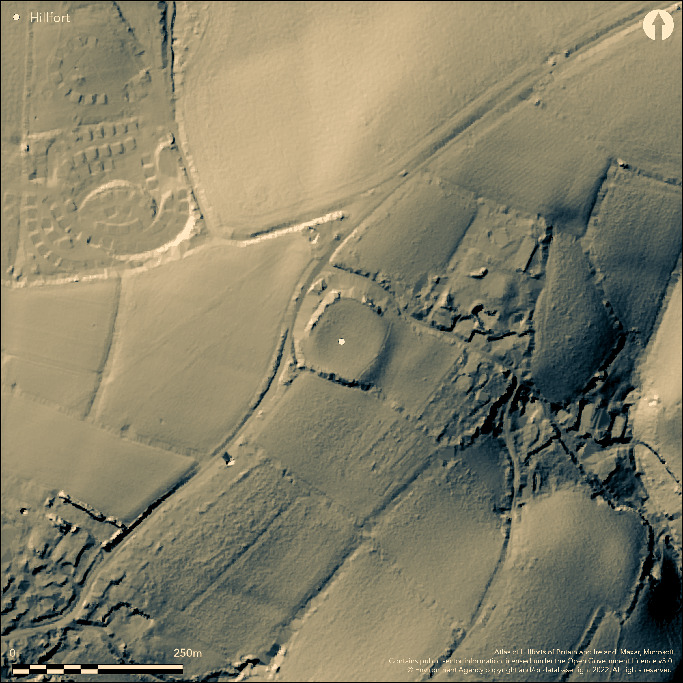
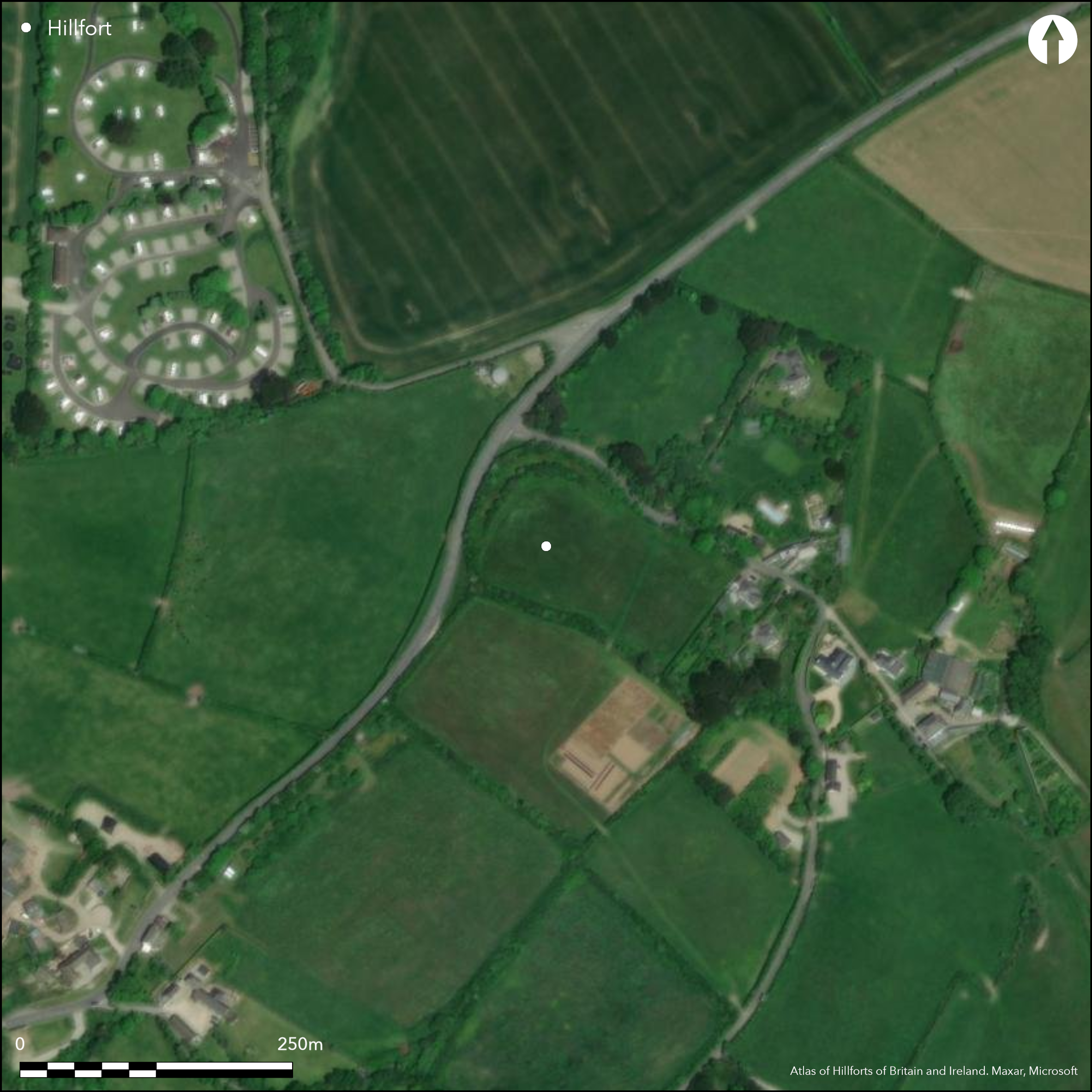
Smal, bivallate, partial contour hillfort with traces of a possible E annexe located above small stream valley overlooking coast at Gerrans Bay. Roughly circular encloses 0.2ha, level interior with moderate surrounding slopes to NW and SW, steeper to E, SE and NW. Outer defences enclose c. 90m diameter. Inner rampart to 3.5m high, almost complete and visible on N and W as bank and on E as scarp. Concentric outer rampart substantial earthwork to 2.6m high incorporated in boundary banks around N, W. Much lost on SE and S side. Medial ditch on aerial photographs and on site visible as low flat strip outside inner rampart. Second and outer ditch, only visible on aerial photographs. Annexe to SE defined by bank and outer ditch, bank visible as low scarp, but ditch seen only on aerial photographs. Fogou (underground chamber) reported, but not located - no details. Possibly visited by John Leland. Pasture interior. Wooded banks to N. Hemmed in by A3078 immediately to NW. On 1st Ed. OS map (1880). Undated.
Citizen Science: ✗
Reliability of Data: Confirmed
Reliability of Interpretation: Confirmed
X: -553188 Y: 6480939 (EPSG: 3857)
Longitude: -4.969369393966229 Latitude: 50.19973656204248 (EPSG:4326)
Country: England
Current County or Unitary Authority: Cornwall
Historic County: Cornwall
Current Parish/Community/Council/Townland: Gerrans
Some substantial banks - others not traceable. Much lost on SE and S side. Ditches only really evident on aerial photographs - medial only flat strip of ground. Hemmed in by A3078 mmediately to NW.
| Extant | ✓ |
| Cropmark | ✗ |
| Likely Destroyed | ✓ |
Pasture interior. Wooded banks to N.
| Woodland | ✓ |
| Commercial Forestry Plantation | ✗ |
| Parkland | ✗ |
| Pasture (Grazing) | ✓ |
| Arable | ✗ |
| Scrub/Bracken | ✗ |
| Bare Outcrop | ✗ |
| Heather/Moorland | ✗ |
| Heath | ✗ |
| Built-up | ✗ |
| Coastal Grassland | ✗ |
| Other | ✗ |
Small, bivallate, roughly circular partial contour hillfort located above small stream valley overlooking coast at Gerrans Bay. Moderate surrounding slopes to NW and SW, steeper to E, SE and NW.
| Contour Fort | ✗ |
| Partial Contour Fort | ✓ |
| Promontory Fort | ✗ |
| Hillslope Fort | ✗ |
| Level Terrain Fort | ✗ |
| Marsh Fort | ✗ |
| Multiple Enclosure Fort | ✗ |
| Hilltop | ✓ |
| Coastal Promontory | ✗ |
| Inland Promontory | ✗ |
| Valley Bottom | ✗ |
| Knoll/Hillock/Outcrop | ✗ |
| Ridge | ✗ |
| Cliff/Plateau-edge/Scarp | ✗ |
| Hillslope | ✗ |
| Lowland | ✗ |
| Spur | ✗ |
Dominant Topographic Feature: Hill top
| North | ✗ |
| Northeast | ✗ |
| East | ✗ |
| Southeast | ✗ |
| South | ✗ |
| Southwest | ✗ |
| West | ✗ |
| Northwest | ✗ |
| Level | ✓ |
Altitude: 79.0m
N/A
None
Reliability: D - None
| Pre 1200BC | ✗ |
| 1200BC - 800BC | ✗ |
| 800BC - 400BC | ✗ |
| 400BC - AD50 | ✗ |
| AD50 - AD400 | ✗ |
| AD400 - AD 800 | ✗ |
| Post AD800 | ✗ |
| Unknown | ✓ |
| Pre Hillfort: | None |
| Post Hillfort: | None |
Possible early reference by T. Hearne 1711 of John Leland visit. On 1st Ed. OS map (1880). Field investigation Ordnance Survey 1968.
| 1st Identified Written Reference (1711): | Possible early reference by Thomas Hearne of Leland visit. |
| 1st Identified Map Depiction (1880): | OS map. |
| Other (1968): | Field investigation OS. |
None.
None
| None | ✓ |
| Spring | ✗ |
| Stream | ✗ |
| Pool | ✗ |
| Flush | ✗ |
| Well | ✗ |
| Other | ✗ |
None
| No Known Features | ✓ |
| Round Stone Structures | ✗ |
| Rectangular Stone Structures | ✗ |
| Curvilinear Platforms | ✗ |
| Other Roundhouse Evidence | ✗ |
| Pits | ✗ |
| Quarry Hollows | ✗ |
| Other | ✗ |
None
| No Known Excavation | ✓ |
| Pits | ✗ |
| Postholes | ✗ |
| Roundhouses | ✗ |
| Rectangular Structures | ✗ |
| Roads/Tracks | ✗ |
| Quarry Hollows | ✗ |
| Other | ✗ |
| Nothing Found | ✗ |
None
| No Known Geophysics | ✓ |
| Pits | ✗ |
| Roundhouses | ✗ |
| Rectangular Structures | ✗ |
| Roads/Tracks | ✗ |
| Quarry Hollows | ✗ |
| Other | ✗ |
| Nothing Found | ✗ |
None
| No Known Finds | ✓ |
| Pottery | ✗ |
| Metal | ✗ |
| Metalworking | ✗ |
| Human Bones | ✗ |
| Animal Bones | ✗ |
| Lithics | ✗ |
| Environmental | ✗ |
| Other | ✗ |
None
| APs Not Checked | ✓ |
| None | ✗ |
| Roundhouses | ✗ |
| Rectangular Structures | ✗ |
| Pits | ✗ |
| Postholes | ✗ |
| Roads/Tracks | ✗ |
| Other | ✗ |
No entrance visible. Possibly on S where rampart gone.
| 0: | None |
| 2: | None |
Guard Chambers: ✗
Chevaux de Frise: ✗
| 1. Simple Gap (South): | Possibly on S where rampart gone. Conjecture. |
Outer defences enclose c. 90m diameter. Inner rampart to 3.5m high, almost complete and visible on N and W as a bank and on E as a scarp. Concentric outer rampart substantial earthwork to 2.6m high incorporated in boundary banks around N, W. Much lost on SE and S sides. Medial ditch seen on on aerial photographs and on site visible as low flat strip outside inner rampart. Second and outer ditch, only visible on aerial photographs.
| Area 1: | 0.2ha. |
| Total: | 0.2ha. |
Total Footprint Area: Noneha.
None
| ✗ | None |
| ✗ | Much lost on SE and S. |
| NE Quadrant: | 2 |
| SE Quadrant: | 1 |
| SW Quadrant: | 2 |
| NW Quadrant: | 2 |
| Total: | 2 |
| Partial Univallate | ✓ |
| Univallate | ✗ |
| Partial Bivallate | ✓ |
| Bivallate | ✗ |
| Partial Multivallate | ✗ |
| Multivallate | ✗ |
| Unknown | ✗ |
| Partial Univallate | ✗ |
| Univallate | ✗ |
| Partial Bivallate | ✗ |
| Bivallate | ✗ |
| Partial Multivallate | ✗ |
| Multivallate | ✗ |
None
| None | ✗ |
| Earthen Bank | ✓ |
| Stone Wall | ✗ |
| Rubble | ✗ |
| Wall-walk | ✗ |
| Evidence of Timber | ✗ |
| Vitrification | ✗ |
| Other Burning | ✗ |
| Palisade | ✗ |
| Counter Scarp Bank | ✗ |
| Berm | ✗ |
| Unfinished | ✗ |
| Other | ✗ |
None
| None | ✗ |
| Earthen Bank | ✗ |
| Stone Wall | ✗ |
| Murus Duplex | ✗ |
| Timber-framed | ✗ |
| Timber-laced | ✗ |
| Vitrification | ✗ |
| Other Burning | ✗ |
| Palisade | ✗ |
| Counter Scarp Bank | ✗ |
| Berm | ✗ |
| Unfinished | ✗ |
| No Known Excavation | ✓ |
| Other | ✗ |
| ✗ | None |
| ✓ | Medial ditch seen on on aerial photographs and on site visible as low flat strip outside inner rampart. Second and outer ditch, only visible on aerial photographs. Annexe ditch only seen on aerial photographs. |
Number of Ditches: 2
| ✓ | Traces of annexe to SE defined by bank and outer ditch, bank visible as low scarp, but ditch seen only on aerial photographs. |
Hearne, T. ed. 1711. The itinerary of John Leland the Antiquary, In 9 Vols, Oxford, (2nd edition 1745).
Page, W. ed. 1906. The Victoria History of the County of Cornwall, 1, London: James Street, 464.
Atlas of Hillforts:
Wikidata:
This work is licensed under CC BY-SA 4.0![]()
![]()
![]() and should be cited as:
and should be cited as:
Lock, Gary and Ralston, Ian. 2024. Atlas of Hillforts of Britain and Ireland. Available at: https://hillforts.arch.ox.ac.uk
Document Version 1.1