LiDAR 1m DTM Hillshade
Satellite Imagery
LiDAR 1m DTM Hillshade
Satellite Imagery
Scroll left/right to view further images.
HER: Cornwall and Scilly MCO63 (17789)
NMR: SX 07 NE 7 (431560)
SM: 1006707
NGR: SX08387958
X: 208387 Y: 79589 (OSGB36)
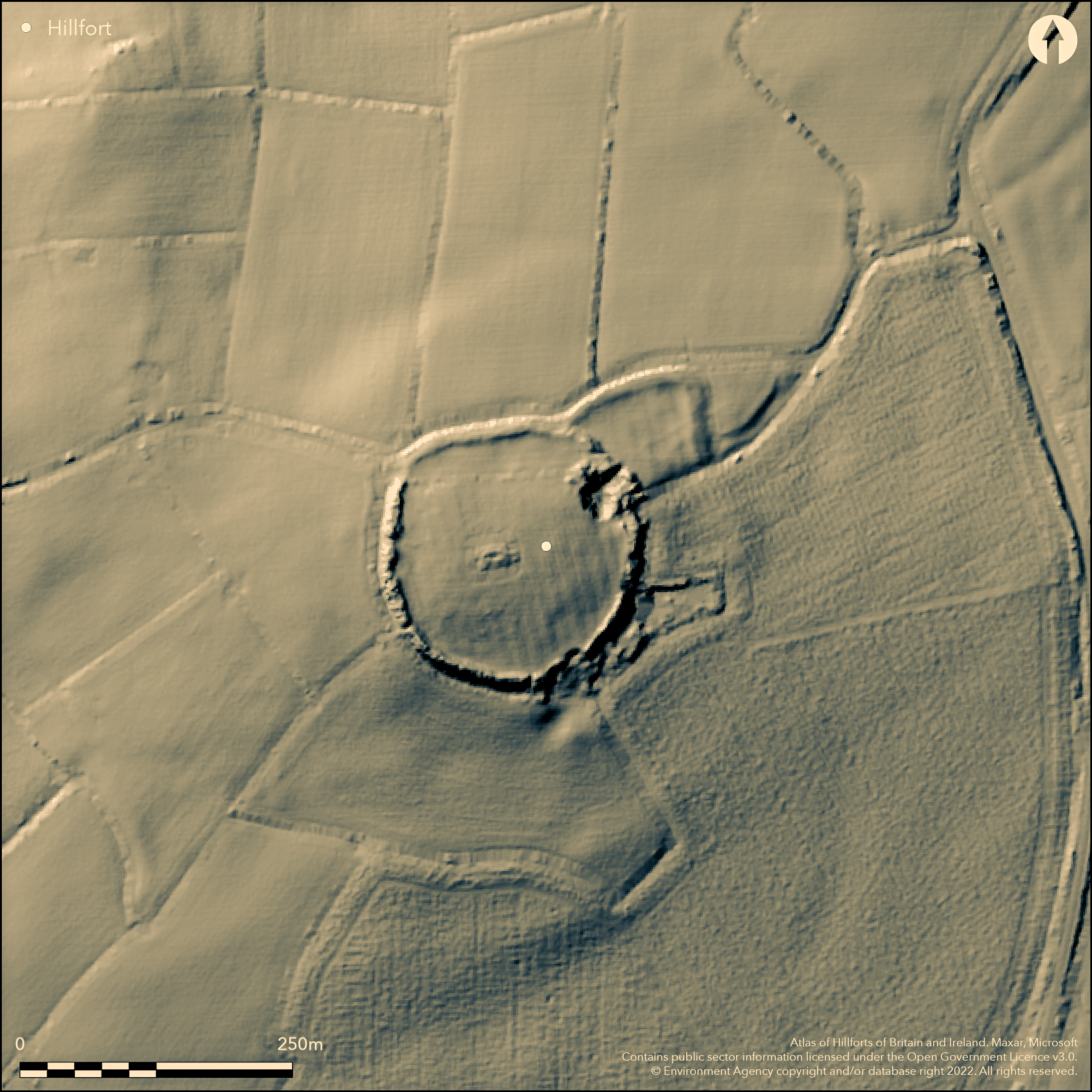
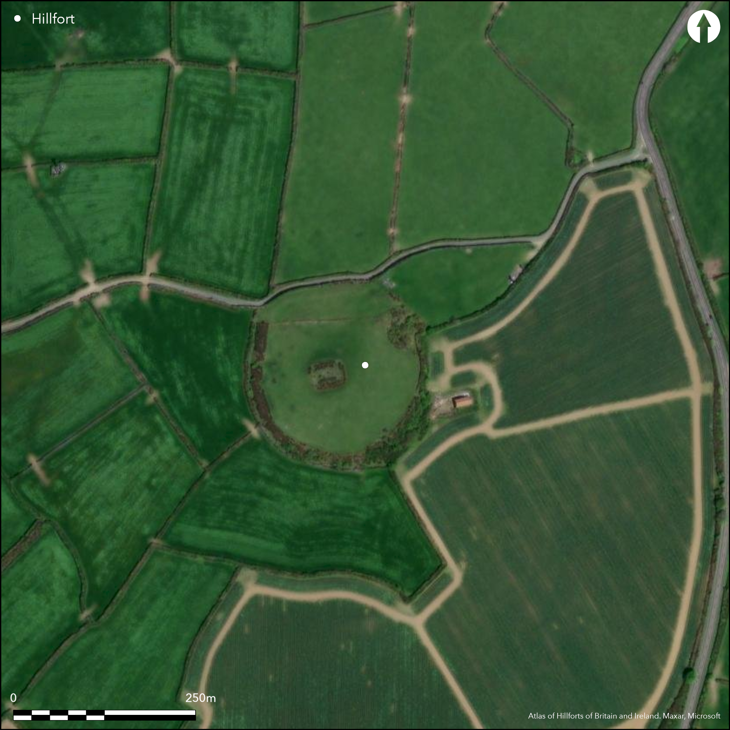
Univallate contour hillfort sited on summit of prominent Michaelstow Beacon, which forms watershed between Rivers Allen and Camel. Site within deer park called New Park documented in 1337. Moderate slopes to E before very steep drop to wooded stream, moderate to N and S, moderate to W before steeper slope. Interior area 1.6ha. Oval enclosure measuring c. 170m long by 160m wide internally. Defined by rampart to 4m high and partially buried outer ditch, cut by road to N. Rectangular outwork, or possible annexe, to E c. 100m long by 40m wide, reported in 1850 (MacLauchlan 1850, 37), now ploughed-down and ditch part buried. Entrance to main enclosure no longer visible, but possible simple gap to outwork/possible annexe with hollow way on E probably original. Within is small, rectangular and wooded, banked enclosure with interior stone facing, and within this is small rectangular two-celled chapel building (called St Syth's Chapel), with walls to 0.6m high and internal cross bank, all set onto low rectangular platform. To W possible tower or beacon surviving as small mound. Chapel has disputed dedication to St Syth or St Michael and partial excavation by Rev. Gibbons in 19th century found no distinctive chapel remains. WWII Home Guard connections. Pasture interior disturbed by stone quarrying. Trees on E, S, W. On 1st Ed. OS map (1881). Undated.
Citizen Science: ✗
Reliability of Data: Confirmed
Reliability of Interpretation: Confirmed
X: -524110 Y: 6548115 (EPSG: 3857)
Longitude: -4.70816098479377 Latitude: 50.584454482806485 (EPSG:4326)
Country: England
Current County or Unitary Authority: Cornwall
Historic County: Cornwall
Current Parish/Community/Council/Townland: Michaelstow
Outworks reported in 1850, now ploughed-down and ditch part buried. Entrance no longer visible and interior and banks disturbed by stone quarrying and cut by road to N. Chapel in mid interior.
| Extant | ✓ |
| Cropmark | ✗ |
| Likely Destroyed | ✓ |
Pasture interior. Trees on E, S, W. Chapel in mid interior. Cut by road on N. Quarrying.
| Woodland | ✓ |
| Commercial Forestry Plantation | ✗ |
| Parkland | ✗ |
| Pasture (Grazing) | ✓ |
| Arable | ✗ |
| Scrub/Bracken | ✗ |
| Bare Outcrop | ✗ |
| Heather/Moorland | ✗ |
| Heath | ✗ |
| Built-up | ✓ |
| Coastal Grassland | ✗ |
| Other | ✓ |
Univallate contour hillfort sited on summit of prominent Michaelstow Beacon, which forms watershed between Rivers Allen and Camel. Moderate slopes to E before very steep drop to wooded stream, moderate to N and S, moderate to W before steeper slope.
| Contour Fort | ✓ |
| Partial Contour Fort | ✗ |
| Promontory Fort | ✗ |
| Hillslope Fort | ✗ |
| Level Terrain Fort | ✗ |
| Marsh Fort | ✗ |
| Multiple Enclosure Fort | ✗ |
| Hilltop | ✓ |
| Coastal Promontory | ✗ |
| Inland Promontory | ✗ |
| Valley Bottom | ✗ |
| Knoll/Hillock/Outcrop | ✗ |
| Ridge | ✗ |
| Cliff/Plateau-edge/Scarp | ✗ |
| Hillslope | ✗ |
| Lowland | ✗ |
| Spur | ✗ |
Dominant Topographic Feature: Hill top
| North | ✗ |
| Northeast | ✗ |
| East | ✗ |
| Southeast | ✗ |
| South | ✗ |
| Southwest | ✗ |
| West | ✗ |
| Northwest | ✗ |
| Level | ✓ |
Altitude: 210.0m
N/A
None for the hillfort.
Reliability: D - None
| Pre 1200BC | ✗ |
| 1200BC - 800BC | ✗ |
| 800BC - 400BC | ✗ |
| 400BC - AD50 | ✗ |
| AD50 - AD400 | ✗ |
| AD400 - AD 800 | ✗ |
| Post AD800 | ✗ |
| Unknown | ✓ |
| Pre Hillfort: | None |
| Post Hillfort: | Site within deer park called New Park documented in 1337. In 1363 the Black Prince ordered a lodge to be built, the location of which is unclear, and it was de-parked in about 1540. Tithe map shows windmill on N side of hillfort, now no visible remains. Within is small, rectangular and wooded, banked enclosure with interior stone facing, and within this is small rectangular two-celled chapel building (called St Syth's Chapel), with walls to 0.6m high and internal cross bank, all set onto low rectangular platform. To W possible tower or beacon surviving as small mound. Chapel has disputed dedication to St Syth or St Michael and partial excavation by Rev. Gibbons in 19th century found no distinctive chapel remains. Home Guard in WWII built an underground observation post in SW side of hillfort. Manned each night, connected by field telephone to Michaelstow House. |
On 1st Ed. OS map (1881). Geophysical survey South West Archaeology 2012.
| 1st Identified Map Depiction (1881): | OS map. |
| Geophysical Survey (2012): | South West Archaeology. |
No hillfort features. Chapel remains and beacon mound. Geophysical survey as part of turbine development, found unspecified prehistoric anomalies.
None
| None | ✓ |
| Spring | ✗ |
| Stream | ✗ |
| Pool | ✗ |
| Flush | ✗ |
| Well | ✗ |
| Other | ✗ |
No hillfort features. Chapel remains and beacon mound.
| No Known Features | ✓ |
| Round Stone Structures | ✗ |
| Rectangular Stone Structures | ✗ |
| Curvilinear Platforms | ✗ |
| Other Roundhouse Evidence | ✗ |
| Pits | ✗ |
| Quarry Hollows | ✗ |
| Other | ✗ |
None
| No Known Excavation | ✓ |
| Pits | ✗ |
| Postholes | ✗ |
| Roundhouses | ✗ |
| Rectangular Structures | ✗ |
| Roads/Tracks | ✗ |
| Quarry Hollows | ✗ |
| Other | ✗ |
| Nothing Found | ✗ |
Geophysical survey as part of turbine development, found unspecified prehistoric anomalies.
| No Known Geophysics | ✗ |
| Pits | ✗ |
| Roundhouses | ✗ |
| Rectangular Structures | ✗ |
| Roads/Tracks | ✗ |
| Quarry Hollows | ✗ |
| Other | ✓ |
| Nothing Found | ✗ |
None
| No Known Finds | ✓ |
| Pottery | ✗ |
| Metal | ✗ |
| Metalworking | ✗ |
| Human Bones | ✗ |
| Animal Bones | ✗ |
| Lithics | ✗ |
| Environmental | ✗ |
| Other | ✗ |
None
| APs Not Checked | ✓ |
| None | ✗ |
| Roundhouses | ✗ |
| Rectangular Structures | ✗ |
| Pits | ✗ |
| Postholes | ✗ |
| Roads/Tracks | ✗ |
| Other | ✗ |
No entrance visible into main enclosure, but simple gap to outwork/possible annexe on E probably original. Hollow way runs through outwork and parts of the rampart.
| 1: | None |
| 2: | None |
Guard Chambers: ✗
Chevaux de Frise: ✗
| 1. Hollow Way (East): | Simple gap to outwork/possible annexe with hollow way on E probably original. Hollow way runs through outwork and also parts of rampart. |
| 1. Outworks (East): | Hollow way runs through outwork and parts of the rampart. |
Oval enclosure measuring c. 170m long by 160m wide internally, with rampart to 4m high and partially buried outer ditch, cut by road to N. Rectangular outwork, or possible annexe, to E c. 100m long by 40m wide. Hollow way runs through entrance of the outwork and parts of the rampart. Outworks reported in 1850, now ploughed down and ditch part buried.
| Area 1: | 1.6ha. |
| Total: | 1.6ha. |
Total Footprint Area: Noneha.
None
| ✗ | None |
| ✓ | Outworks/possible annexe, not included as part of circuit. |
| NE Quadrant: | 1 |
| SE Quadrant: | 1 |
| SW Quadrant: | 1 |
| NW Quadrant: | 1 |
| Total: | 1 |
| Partial Univallate | ✗ |
| Univallate | ✓ |
| Partial Bivallate | ✗ |
| Bivallate | ✗ |
| Partial Multivallate | ✗ |
| Multivallate | ✗ |
| Unknown | ✗ |
| Partial Univallate | ✗ |
| Univallate | ✗ |
| Partial Bivallate | ✗ |
| Bivallate | ✗ |
| Partial Multivallate | ✗ |
| Multivallate | ✗ |
None
| None | ✗ |
| Earthen Bank | ✓ |
| Stone Wall | ✗ |
| Rubble | ✗ |
| Wall-walk | ✗ |
| Evidence of Timber | ✗ |
| Vitrification | ✗ |
| Other Burning | ✗ |
| Palisade | ✗ |
| Counter Scarp Bank | ✗ |
| Berm | ✗ |
| Unfinished | ✗ |
| Other | ✗ |
None
| None | ✗ |
| Earthen Bank | ✗ |
| Stone Wall | ✗ |
| Murus Duplex | ✗ |
| Timber-framed | ✗ |
| Timber-laced | ✗ |
| Vitrification | ✗ |
| Other Burning | ✗ |
| Palisade | ✗ |
| Counter Scarp Bank | ✗ |
| Berm | ✗ |
| Unfinished | ✗ |
| No Known Excavation | ✓ |
| Other | ✗ |
| ✗ | None |
| ✓ | Part buried outer ditch. |
Number of Ditches: 1
| ✓ | Rectangular outwork, or possible annexe, to E c. 100m long by 40m wide. Hollow way runs through entrance of the outwork and parts of the rampart. Outworks reported in 1850, now ploughed-down and ditch part buried. |
Morris B., Walls S. and Wapshott E. 2012. Tregawn Farm, Michaelstow, Cornwall: results of a desk-based assessment, geophysical survey, walkover survey and visual impact assessment, Report No 121031,
Unpublished evaluation and assessment report, South West Archaeology.
MacLauchlan, H. 1850. Annual report, Royal Inst Cornwall, 32, 37, Plate 29, Fig i.
Atlas of Hillforts:
Wikidata:
This work is licensed under CC BY-SA 4.0![]()
![]()
![]() and should be cited as:
and should be cited as:
Lock, Gary and Ralston, Ian. 2024. Atlas of Hillforts of Britain and Ireland. Available at: https://hillforts.arch.ox.ac.uk
Document Version 1.1