LiDAR 1m DTM Hillshade
Satellite Imagery
LiDAR 1m DTM Hillshade
Satellite Imagery
Scroll left/right to view further images.
HER: Cornwall and Scilly MCO70 (31695)
NMR: SW 43 SE 8 (423950)
SM: 1003270
NGR: SW 4754 3104
X: 147540 Y: 31040 (OSGB36)
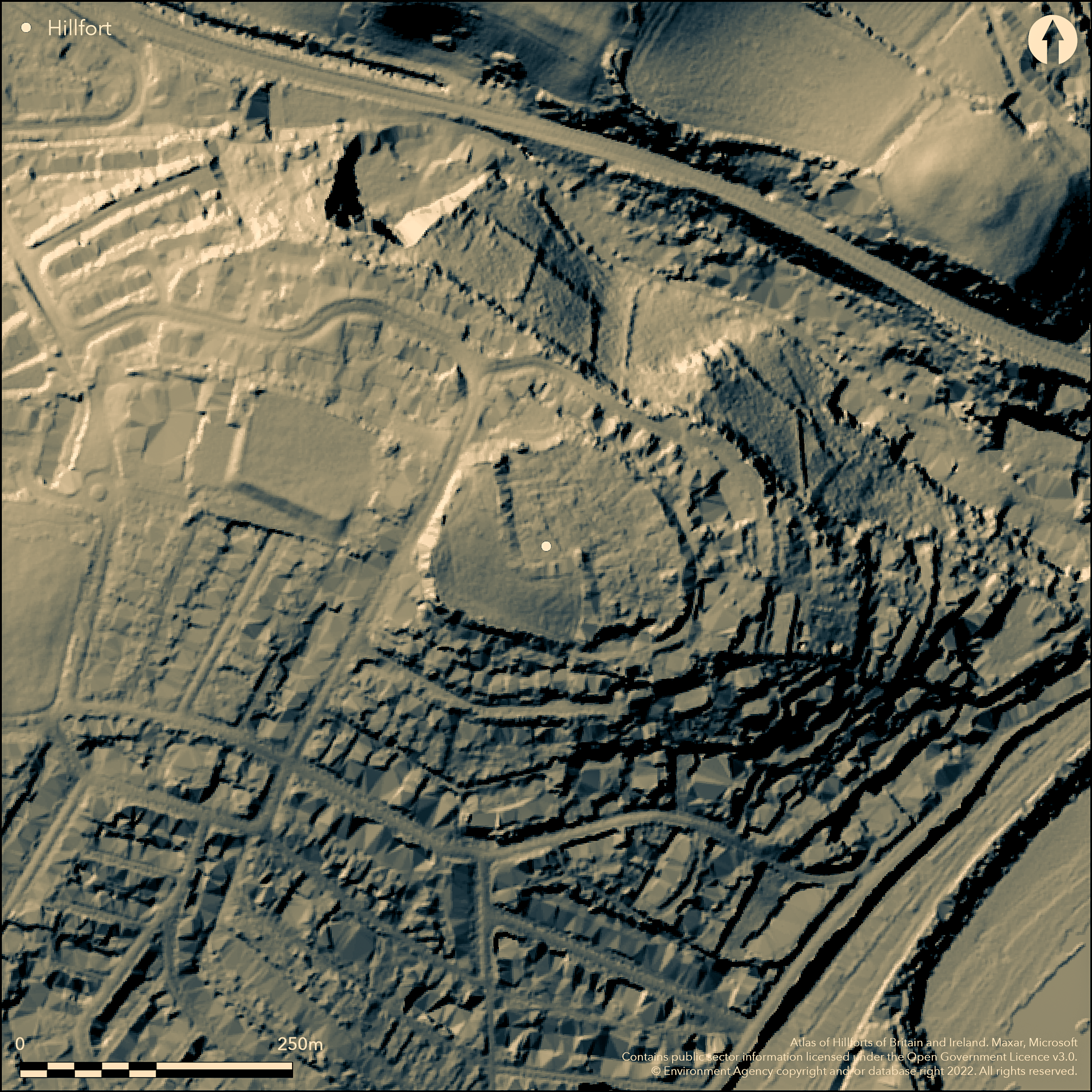
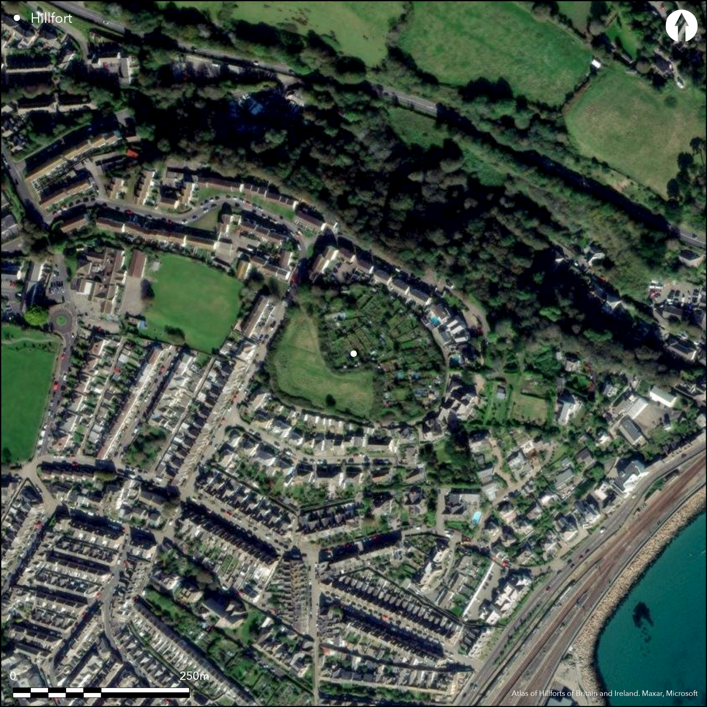
Virtually destroyed, univallate, contour hillfort located at SE end of ridge with commanding views over Mount's Bay, Penzance. Surrounding slopes very steep SE and NE, less so to SW, very gentle to NW. Plan of c. 1.2ha can only be deduced from existing property boundaries, with only possible rampart in W half. Here an overgrown outer slope, c. 2m to 5.5m wide and c. 1.5m to 4m high, with no trace of outer ditch, but its course recorded in 1958 to c. 3m-3.5m deep. On top is hedge and possible vestige of inner slope 1m to 2m wide and 0.3m to 0.6m high, but may be remnants of a field bank. Around E half Cornish hedging retains interior c. 1m to 1.5m high. Entrance possibly to NW, now into pasture field, where 3m high mound of earth on N side may be the simple entrance with club terminals. Possible protecting outworks. Outer rampart possible, especially to N, coinciding with crest of Chyandour Valley. Wide terrace for c. 15m on N with drop of 4m possibly recent. Quarry hollows suggested by small excavation 2005-06. Called 'the place of a palace of Cradock'. Visited by W. Borlase in 18th century. All but lost now and surrounded by development. On OS 1:500 town plan (1876). Undated.
Citizen Science: ✗
Reliability of Data: Confirmed
Reliability of Interpretation: Confirmed
X: -616000 Y: 6468045 (EPSG: 3857)
Longitude: -5.533618761731001 Latitude: 50.12553865615195 (EPSG:4326)
Country: England
Current County or Unitary Authority: Cornwall
Historic County: Cornwall
Current Parish/Community/Council/Townland: Penzance
Surrounded and almost destroyed by development. Interior now allotments, gardens, paddocks and E and N covered by houses and gardens. Rampart lost, but course of ditch recorded in 1958. One-third of site formerly ploughed. Wide terrace for c. 15m on N with drop of 4m possibly recent.
| Extant | ✗ |
| Cropmark | ✗ |
| Likely Destroyed | ✓ |
Mostly built-up.
| Woodland | ✗ |
| Commercial Forestry Plantation | ✗ |
| Parkland | ✗ |
| Pasture (Grazing) | ✓ |
| Arable | ✗ |
| Scrub/Bracken | ✓ |
| Bare Outcrop | ✗ |
| Heather/Moorland | ✗ |
| Heath | ✗ |
| Built-up | ✓ |
| Coastal Grassland | ✗ |
| Other | ✗ |
Virtually destroyed, univallate, contour hillfort encloses SE end of ridge with commanding views over Mount's Bay, Penzance. Surrounding slopes very steep SE and NE, less so to SW, very gentle to NW.
| Contour Fort | ✓ |
| Partial Contour Fort | ✗ |
| Promontory Fort | ✗ |
| Hillslope Fort | ✗ |
| Level Terrain Fort | ✗ |
| Marsh Fort | ✗ |
| Multiple Enclosure Fort | ✗ |
Sited on a high site overlooking Mounts Bay with steep sides on the north, south and east, less so on west
| Hilltop | ✓ |
| Coastal Promontory | ✗ |
| Inland Promontory | ✗ |
| Valley Bottom | ✗ |
| Knoll/Hillock/Outcrop | ✗ |
| Ridge | ✗ |
| Cliff/Plateau-edge/Scarp | ✗ |
| Hillslope | ✗ |
| Lowland | ✗ |
| Spur | ✗ |
Dominant Topographic Feature: Hill top
| North | ✗ |
| Northeast | ✗ |
| East | ✗ |
| Southeast | ✗ |
| South | ✗ |
| Southwest | ✗ |
| West | ✗ |
| Northwest | ✗ |
| Level | ✓ |
Altitude: 65.0m
N/A
None.
Reliability: D - None
| Pre 1200BC | ✗ |
| 1200BC - 800BC | ✗ |
| 800BC - 400BC | ✗ |
| 400BC - AD50 | ✗ |
| AD50 - AD400 | ✗ |
| AD400 - AD 800 | ✗ |
| Post AD800 | ✗ |
| Unknown | ✓ |
| Pre Hillfort: | None |
| Post Hillfort: | None |
W. Borlase's visit in first half of the 18th century. On OS 1:500 town plan (1876). Detailed report prepared for Penwith District Council by S. Hartgroves, Cornwall Archaeological Unit, in December 1986. Evaluation - Cornwall Archaeological Unit 2005-06 - two test-pits excavated following geophysical survey, found possible rampart internal quarry ditch. Desk assessment, Cornwall Archaeological Unit 2006. RCHME survey, ref. no. 621663.
| Other (1870): | Lake's parohcial history of Cornwall reference. |
| 1st Identified Map Depiction (1876): | On OS 1:500 town plan. |
| Other (1986): | Detailed report prepared for Penwith District Council by S. Hartgroves, Cornwall Archaeological Unit. |
| Other (2006): | Desk assessment, Cornwall Archaeological Unit. |
| Other (2006): | Visited by Hillfort Study Group |
| Other (2007): | Management survey, Cornwall Archaeological Unit. |
| 1st Identified Written Reference (None): | W. Borlase's visit. |
| Earthwork Survey (None): | None |
| Excavation (None): | Evaluation, Cornwall Archaeological Unit. |
Two test-pits excavated following geophysical survey, found possible rampart internal quarry ditch.
None
| None | ✓ |
| Spring | ✗ |
| Stream | ✗ |
| Pool | ✗ |
| Flush | ✗ |
| Well | ✗ |
| Other | ✗ |
None
| No Known Features | ✓ |
| Round Stone Structures | ✗ |
| Rectangular Stone Structures | ✗ |
| Curvilinear Platforms | ✗ |
| Other Roundhouse Evidence | ✗ |
| Pits | ✗ |
| Quarry Hollows | ✗ |
| Other | ✗ |
Two test-pits excavated following geophysical survey, found possible rampart internal quarry ditch.
| No Known Excavation | ✗ |
| Pits | ✗ |
| Postholes | ✗ |
| Roundhouses | ✗ |
| Rectangular Structures | ✗ |
| Roads/Tracks | ✗ |
| Quarry Hollows | ✓ |
| Other | ✗ |
| Nothing Found | ✗ |
Excavation followed geophysical survey.
| No Known Geophysics | ✗ |
| Pits | ✗ |
| Roundhouses | ✗ |
| Rectangular Structures | ✗ |
| Roads/Tracks | ✗ |
| Quarry Hollows | ✓ |
| Other | ✓ |
| Nothing Found | ✗ |
None
| No Known Finds | ✓ |
| Pottery | ✗ |
| Metal | ✗ |
| Metalworking | ✗ |
| Human Bones | ✗ |
| Animal Bones | ✗ |
| Lithics | ✗ |
| Environmental | ✗ |
| Other | ✗ |
None
| APs Not Checked | ✓ |
| None | ✗ |
| Roundhouses | ✗ |
| Rectangular Structures | ✗ |
| Pits | ✗ |
| Postholes | ✗ |
| Roads/Tracks | ✗ |
| Other | ✗ |
Entrance possibly to NW, now into pasture field; a 3m high mound of earth on N side may be the simple entrance with club terminals. Possible protecting outworks.
| 1: | Entrance lost but possible on NW. |
| 2: | None |
Guard Chambers: ✗
Chevaux de Frise: ✗
| 1. Simple Gap (North west): | Club terminals |
| 1. Outworks (North west): | Possible protecting outworks. |
Plan can only be deduced from from existing property boundaries, and only in W half of perimeter possible rampart. Here overgrown, outer slope 2m to 5.5m wide and c. 1.5m to 4m high. Now no traces of outer ditch, but course recorded in 1958 to c. 3m-3.5m deep. On top is hedge and possible vestige of inner slope 1m to 2m wide and 0.3m to 0.6m high, but may be remnants of a field bank. Around E half Cornish hedging retains interior c. 1m to 1.5m high. Wide terrace for c. 5m on N, with drop of 4m, possibly recent.
| Area 1: | 1.2ha. |
| Total: | 1.2ha. |
Total Footprint Area: Noneha.
None
| ✗ | None |
| ✗ | Ramparts lost. Formerly univallate around circuit. |
| NE Quadrant: | 0 |
| SE Quadrant: | 0 |
| SW Quadrant: | 0 |
| NW Quadrant: | 0 |
| Total: | 0 |
| Partial Univallate | ✗ |
| Univallate | ✗ |
| Partial Bivallate | ✗ |
| Bivallate | ✗ |
| Partial Multivallate | ✗ |
| Multivallate | ✗ |
| Unknown | ✓ |
| Partial Univallate | ✗ |
| Univallate | ✗ |
| Partial Bivallate | ✗ |
| Bivallate | ✗ |
| Partial Multivallate | ✗ |
| Multivallate | ✗ |
Earth and stone bank.
| None | ✗ |
| Earthen Bank | ✓ |
| Stone Wall | ✗ |
| Rubble | ✓ |
| Wall-walk | ✗ |
| Evidence of Timber | ✗ |
| Vitrification | ✗ |
| Other Burning | ✗ |
| Palisade | ✗ |
| Counter Scarp Bank | ✗ |
| Berm | ✗ |
| Unfinished | ✗ |
| Other | ✗ |
None
| None | ✗ |
| Earthen Bank | ✗ |
| Stone Wall | ✗ |
| Murus Duplex | ✗ |
| Timber-framed | ✗ |
| Timber-laced | ✗ |
| Vitrification | ✗ |
| Other Burning | ✗ |
| Palisade | ✗ |
| Counter Scarp Bank | ✗ |
| Berm | ✗ |
| Unfinished | ✗ |
| No Known Excavation | ✓ |
| Other | ✗ |
| ✗ | None |
| ✗ | No traces of outer ditch. |
Number of Ditches: 0
| ✗ | None |
Anon 1870. A complete parochial history of the County of Cornwall, 3, London and Truro: J. C. Hotten and W. Lake, 226.
Gaffney, C. 2005. Lescudjack hillfort, Penzance 2005/77, GSB, unpublished.
Kirkham, G. 2006. Lescudjack hillfort, Penzance, Cornwall: archaeological assessment, Report No 06R003, Cornwall Archaeological Unit, Cornwall County Council.
Kirkham, G. 2006. Lescudjack Hillfort, Penzance, Cornwall. Archaeological Assessment, Cornwall Archaeological Unit assessment and evaluation reports, Cornwall County Council.
Kirkham, G. 2007. Lescudjack Hillfort, Penzance, Cornwall. Management Plan, Cornwall Archaeological Unit assessment and evaluation report, Cornwall County Council.
Page, W. ed. 1906. The Victoria History of the County of Cornwall, 1, London: James Street, 456.
Atlas of Hillforts:
Wikidata:
This work is licensed under CC BY-SA 4.0![]()
![]()
![]() and should be cited as:
and should be cited as:
Lock, Gary and Ralston, Ian. 2024. Atlas of Hillforts of Britain and Ireland. Available at: https://hillforts.arch.ox.ac.uk
Document Version 1.1