LiDAR 1m DTM Hillshade
Satellite Imagery
LiDAR 1m DTM Hillshade
Satellite Imagery
Scroll left/right to view further images.
HER: Cornwall and Scilly MCO76 (20898)
NMR: SW 95 SW 6 (430166)
SM: 1017685
NGR: SW94005104
X: 194000 Y: 51040 (OSGB36)
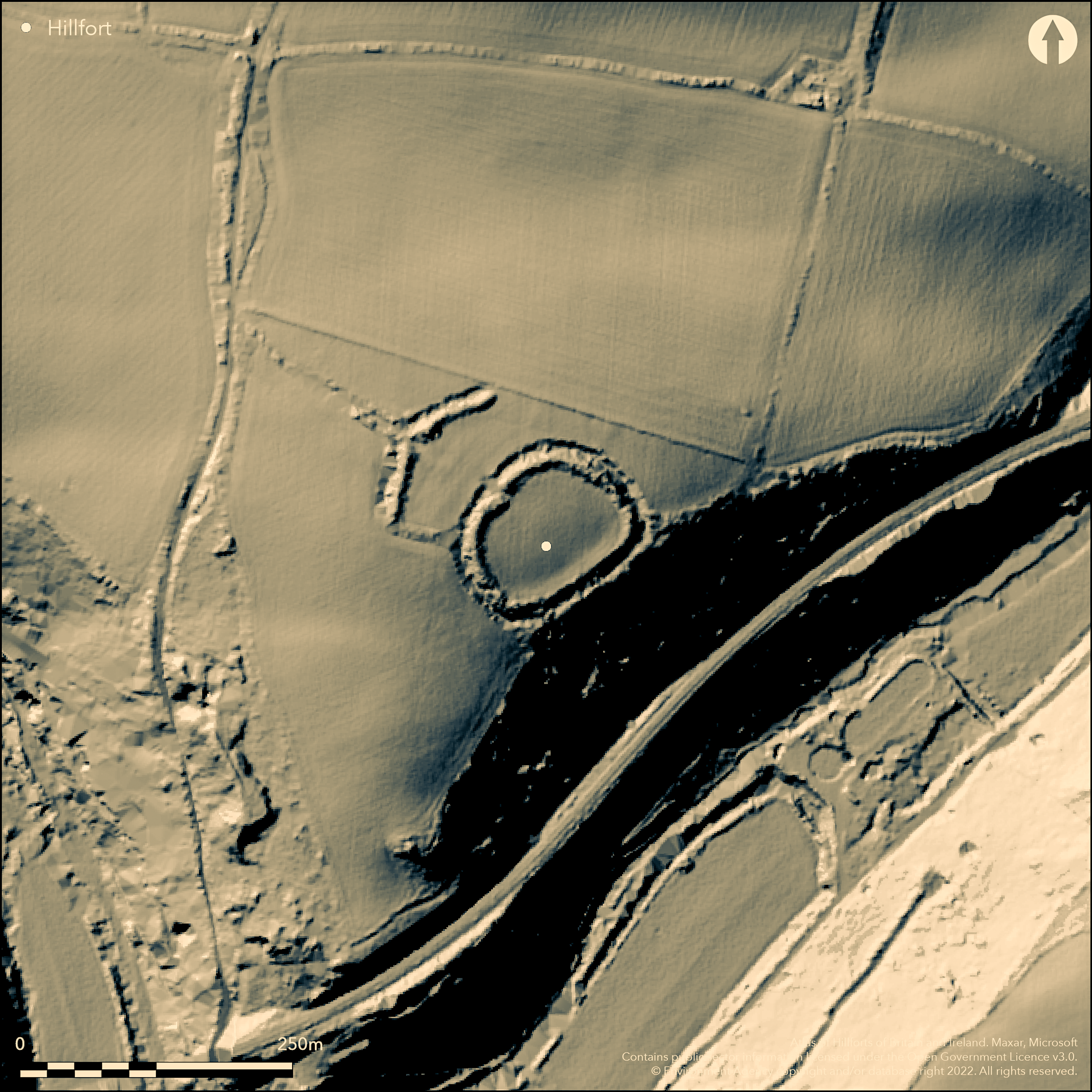
Oval, complex, multiple enclosure hillfort straddling summit of Crow Hill, main enclosure lying on gentle SE-facing slope bordering very steep slope down to St Stephens River valley and close to its confluence with River Fal. On Devonian slates SW of Hensbarrow Downs granite mass, in hilly terrain deeply dissected by small rivers. Commanding views, especially to W. Outerwork of bank and ditch along top edge of slope to N. Surrounding slopes to SW and SE wooded. Sub-circular area 70m by 60m encloses c. 0.3ha, flattened along SE where follows crest of steep scarp to St Stephens River. Earth and rubble rampart, c. 2m high and 10m wide along NW, with terminals bordering entrance gap, and reduced to 0.5m high along to SE. Outer ditch c. 1m-1.5m deep, with rock-cut outer face. Recent dry-stone supporting wall also in parts of ditch outer face, notably S and W sectors. To NW outer enclosure has two sections of rampart c. 45m long, each parallel with, and 35m-40m from, main enclosure, and separated by entrance gap in line with that of main enclosure. Each to c. 2m high and 10m wide with outer ditch 1m-1.5m deep. Beyond these ditches, hollowed route-way formed by double bank and central ditch extends in straight line NW from enclosure entrance for c. 55m, continued beyond by single recent hedge bank extending line of N bank. Main enclosure entrance on NW opposing central entrance of outwork from which hollow-way runs NW. Outerwork never connected to main enclosure, the feature connecting on W is field bank. Interior formerly ploughed, now pasture. Ramparts tree covered. Well-preserved. On 1st Ed. OS map (1881). Undated.
Citizen Science: ✗
Reliability of Data: Confirmed
Reliability of Interpretation: Confirmed
X: -544956 Y: 6502427 (EPSG: 3857)
Longitude: -4.895420864006776 Latitude: 50.32313594680605 (EPSG:4326)
Country: England; None
Current County or Unitary Authority: Cornwall
Historic County: Cornwall
Current Parish/Community/Council/Townland: St Stephen-in-Brannel; Probus
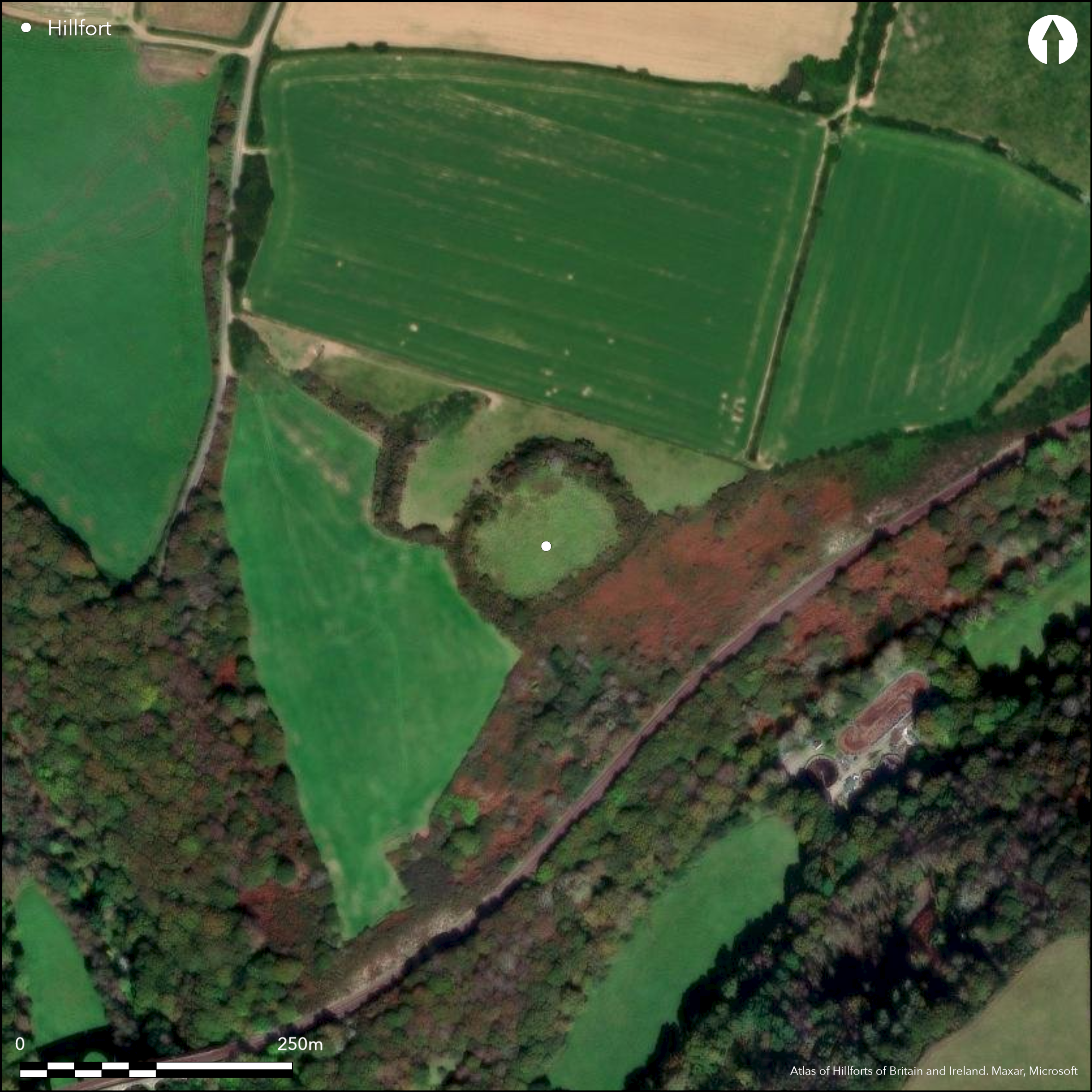
Ploughed/pasture interior, else good condition. Management agreement, with visitor car park and information board,
| Extant | ✓ |
| Cropmark | ✗ |
| Likely Destroyed | ✗ |
Interior formerly ploughed, now pasture. Ramparts tree covered.
| Woodland | ✓ |
| Commercial Forestry Plantation | ✗ |
| Parkland | ✗ |
| Pasture (Grazing) | ✓ |
| Arable | ✗ |
| Scrub/Bracken | ✗ |
| Bare Outcrop | ✗ |
| Heather/Moorland | ✗ |
| Heath | ✗ |
| Built-up | ✗ |
| Coastal Grassland | ✗ |
| Other | ✗ |
Oval multiple enclosure hillfort straddling summit of Crow Hill, main enclosure lying on gentle SE-facing slope bordering very steep slope down to St Stephens River valley and close to its confluence with River Fal.
| Contour Fort | ✗ |
| Partial Contour Fort | ✗ |
| Promontory Fort | ✗ |
| Hillslope Fort | ✗ |
| Level Terrain Fort | ✗ |
| Marsh Fort | ✗ |
| Multiple Enclosure Fort | ✓ |
Located on Crown Hill overlooking the confluence of the River Fal and a tributary
| Hilltop | ✗ |
| Coastal Promontory | ✗ |
| Inland Promontory | ✗ |
| Valley Bottom | ✗ |
| Knoll/Hillock/Outcrop | ✗ |
| Ridge | ✗ |
| Cliff/Plateau-edge/Scarp | ✗ |
| Hillslope | ✗ |
| Lowland | ✗ |
| Spur | ✓ |
Dominant Topographic Feature: Spur
| North | ✗ |
| Northeast | ✗ |
| East | ✗ |
| Southeast | ✓ |
| South | ✗ |
| Southwest | ✗ |
| West | ✗ |
| Northwest | ✗ |
| Level | ✗ |
Altitude: 95.0m
Close to parish boundary
Boundary Type: Parish/Townland
None.
Reliability: D - None
| Pre 1200BC | ✗ |
| 1200BC - 800BC | ✗ |
| 800BC - 400BC | ✗ |
| 400BC - AD50 | ✗ |
| AD50 - AD400 | ✗ |
| AD400 - AD 800 | ✗ |
| Post AD800 | ✗ |
| Unknown | ✓ |
| Pre Hillfort: | None |
| Post Hillfort: | None |
On 1st Ed. OS map (1881). DOE investigations 1958, 1980.
| 1st Identified Map Depiction (1881): | OS map. |
| Other (None): | DOE investigations. |
Interior featureless.
None
| None | ✓ |
| Spring | ✗ |
| Stream | ✗ |
| Pool | ✗ |
| Flush | ✗ |
| Well | ✗ |
| Other | ✗ |
Interior featureless.
| No Known Features | ✓ |
| Round Stone Structures | ✗ |
| Rectangular Stone Structures | ✗ |
| Curvilinear Platforms | ✗ |
| Other Roundhouse Evidence | ✗ |
| Pits | ✗ |
| Quarry Hollows | ✗ |
| Other | ✗ |
None
| No Known Excavation | ✓ |
| Pits | ✗ |
| Postholes | ✗ |
| Roundhouses | ✗ |
| Rectangular Structures | ✗ |
| Roads/Tracks | ✗ |
| Quarry Hollows | ✗ |
| Other | ✗ |
| Nothing Found | ✗ |
None
| No Known Geophysics | ✓ |
| Pits | ✗ |
| Roundhouses | ✗ |
| Rectangular Structures | ✗ |
| Roads/Tracks | ✗ |
| Quarry Hollows | ✗ |
| Other | ✗ |
| Nothing Found | ✗ |
None
| No Known Finds | ✓ |
| Pottery | ✗ |
| Metal | ✗ |
| Metalworking | ✗ |
| Human Bones | ✗ |
| Animal Bones | ✗ |
| Lithics | ✗ |
| Environmental | ✗ |
| Other | ✗ |
None
| APs Not Checked | ✓ |
| None | ✗ |
| Roundhouses | ✗ |
| Rectangular Structures | ✗ |
| Pits | ✗ |
| Postholes | ✗ |
| Roads/Tracks | ✗ |
| Other | ✗ |
Main enclosure has entrance on NW opposing the central entrance of the outwork from which the hollow-way runs NW.
| 1: | Main enclosure. |
| 2: | None |
Guard Chambers: ✗
Chevaux de Frise: ✗
| 1. Hollow Way (North west): | None |
| 1. Outworks (North west): | None |
Earth and rubble rampart, c. 2m high and 10m wide along NW side of enclosure, with slightly expanded terminals bordering an entrance gap, and reduced to 0.5m high along to SE. An outer ditch c. 1m-1.5m deep, with a rock- cut outer face visible. Recent dry-stone supporting wall also in parts of ditch outer face, notably S and W sectors. To NW outer enclosure has two sections of rampart c. 45m long, each parallel with, and 35m-40m from, main enclosure, and separated by entrance gap in line with that of the main enclosure. Each to c. 2m high and 10m wide with outer ditch 1m-1.5m deep. Beyond these ditches, hollowed route-way formed by double bank and central ditch extends in straight line NW from the enclosure entrance for c. 55m, continued beyond by single recent hedge bank extending line of N bank.
| Area 1: | 0.3ha. |
| Total: | 0.3ha. |
Total Footprint Area: Noneha.
None
| ✗ | Area of outer enclosure not determined |
| ✓ | Complex. Main enclosure quadrants only determined. |
| NE Quadrant: | 1 |
| SE Quadrant: | 1 |
| SW Quadrant: | 1 |
| NW Quadrant: | 1 |
| Total: | 1 |
| Partial Univallate | ✗ |
| Univallate | ✓ |
| Partial Bivallate | ✗ |
| Bivallate | ✗ |
| Partial Multivallate | ✗ |
| Multivallate | ✗ |
| Unknown | ✗ |
| Partial Univallate | ✗ |
| Univallate | ✗ |
| Partial Bivallate | ✗ |
| Bivallate | ✗ |
| Partial Multivallate | ✗ |
| Multivallate | ✗ |
Earth and rubble rampart.
| None | ✗ |
| Earthen Bank | ✓ |
| Stone Wall | ✗ |
| Rubble | ✓ |
| Wall-walk | ✗ |
| Evidence of Timber | ✗ |
| Vitrification | ✗ |
| Other Burning | ✗ |
| Palisade | ✗ |
| Counter Scarp Bank | ✗ |
| Berm | ✗ |
| Unfinished | ✗ |
| Other | ✗ |
None
| None | ✗ |
| Earthen Bank | ✗ |
| Stone Wall | ✗ |
| Murus Duplex | ✗ |
| Timber-framed | ✗ |
| Timber-laced | ✗ |
| Vitrification | ✗ |
| Other Burning | ✗ |
| Palisade | ✗ |
| Counter Scarp Bank | ✗ |
| Berm | ✗ |
| Unfinished | ✗ |
| No Known Excavation | ✓ |
| Other | ✗ |
| ✗ | None |
| ✓ | None |
Number of Ditches: 2
| ✗ | None |
Dowson, E., Sheppard, P. and Thomas, C. 1970, Parochal check-lists of antiquities, Cornish Archaeol, 9, 145.
Page, W. ed. 1906. The Victoria History of the County of Cornwall, 1, London: James Street, 464.
Polsue, J. ed. 1867-72. Lake's Parochial History of Cornwall, Vol 1, 162.
Atlas of Hillforts:
Wikidata:
This work is licensed under CC BY-SA 4.0![]()
![]()
![]() and should be cited as:
and should be cited as:
Lock, Gary and Ralston, Ian. 2024. Atlas of Hillforts of Britain and Ireland. Available at: https://hillforts.arch.ox.ac.uk
Document Version 1.1