
LiDAR 1m DTM Hillshade
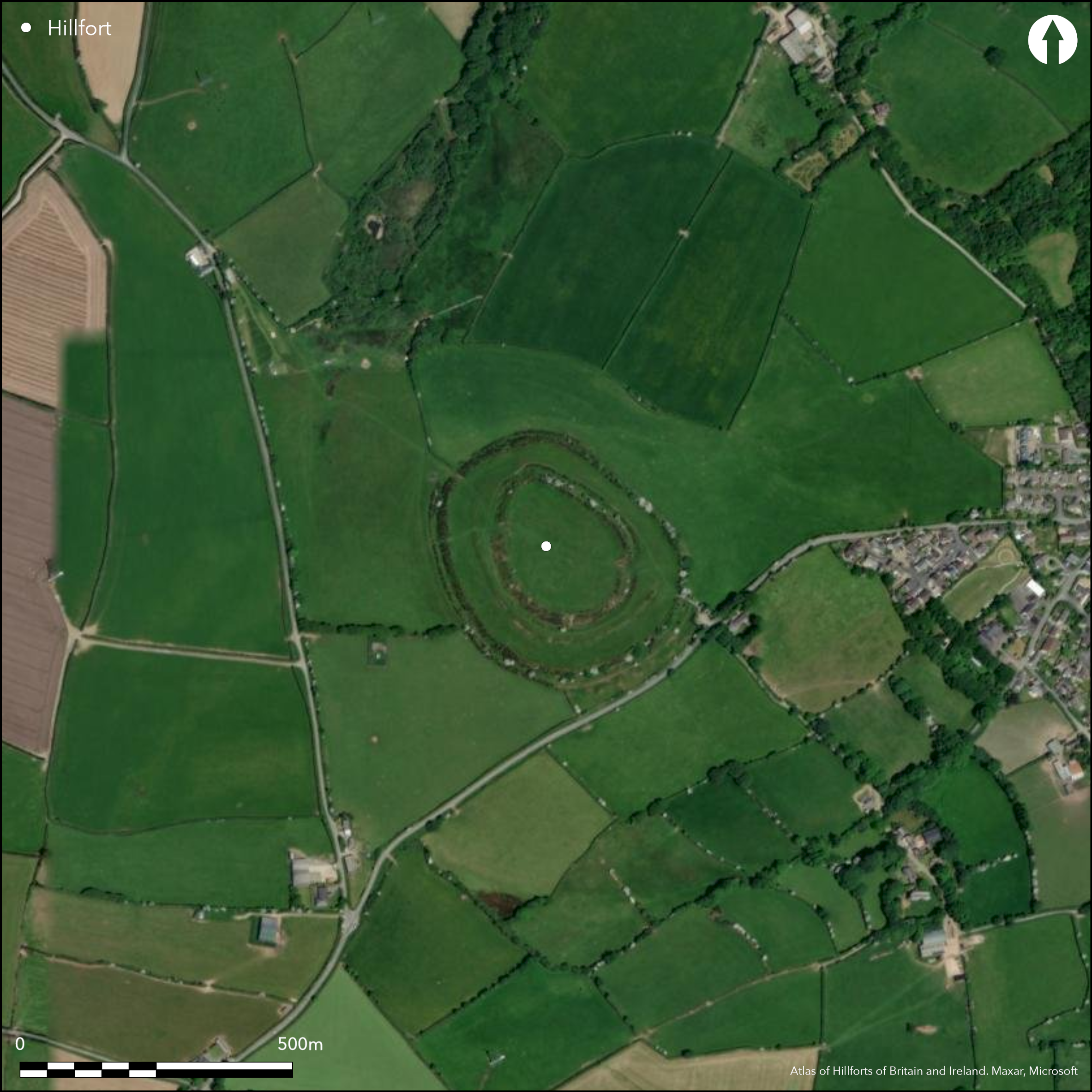
Satellite Imagery
LiDAR 1m DTM Hillshade
Satellite Imagery
Scroll left/right to view further images.
HER: Cornwall and Scilly MCO88 (2156)
NMR: SX 29 SW 1 (1006710)
SM: 1006710
NGR: SX20129077
X: 220120 Y: 90770 (OSGB36)
Large, multiple enclosure hillfort located on NE-facing slope of prominent upland ridge at heads of two tributaries of River Ottery which surrounds the site at a distance to N, E, W. One of the largest and best preserved hillforts in Cornwall. Steep surrounding slopes to N, E less so on W, the SE side above a steep stream valley. Two concentric and massive widely-spaced ramparts to 5.8m high with ditches to 2.7m deep and outer counterscarp bank. Inner enclosure of 1.8ha, larger of 5.1ha. Between these main ramparts, but confined to S half of site, is lower middle rampart with ditch. Outer rampart has two simple entrance gaps to NW and SE, the inner rampart with two corresponding inturned entrances, also to NW and SE. In centre of inner enclosed area is large pillow mound (artificial earthen mound used for keeping rabbits), visible as rectangular mound c. 22m long, 10m wide and 0.6m high with buried side ditches and traditionally the burial place of the Giant of Warbstow, who was killed by the Giant of Beacon, and now called the 'Giant's Grave'. First depicted on 1" 1813 OS map and discussed by 19th century antiquaries. Pasture interiors. Scrub and trees on ramparts around circuits. On 1st Ed. OS map (1884). Undated.
Citizen Science: ✗
Reliability of Data: Confirmed
Reliability of Interpretation: Confirmed
X: -506284 Y: 6566401 (EPSG: 3857)
Longitude: -4.548025761635902 Latitude: 50.68863973877434 (EPSG:4326)
Country: England
Current County or Unitary Authority: Cornwall
Historic County: Cornwall
Current Parish/Community/Council/Townland: Warbstow
Very low rampart on N side, but one of the best preserved hillforts in Cornwall. On Heritage at Risk Register (2015).
| Extant | ✓ |
| Cropmark | ✗ |
| Likely Destroyed | ✗ |
Pasture interiors. Scrub and trees on ramparts around circuits.
| Woodland | ✗ |
| Commercial Forestry Plantation | ✗ |
| Parkland | ✗ |
| Pasture (Grazing) | ✓ |
| Arable | ✗ |
| Scrub/Bracken | ✓ |
| Bare Outcrop | ✗ |
| Heather/Moorland | ✗ |
| Heath | ✗ |
| Built-up | ✗ |
| Coastal Grassland | ✗ |
| Other | ✗ |
Large, multiple enclosure, hillslope hillfort sited on NE-facing slope of prominent upland ridge at heads of two tributaries of River Ottery which surrounds the site at a distance to N, E, W. Steep surrounding slopes to N, E less so on W, the SE side above a steep stream valley.
| Contour Fort | ✗ |
| Partial Contour Fort | ✗ |
| Promontory Fort | ✗ |
| Hillslope Fort | ✓ |
| Level Terrain Fort | ✗ |
| Marsh Fort | ✗ |
| Multiple Enclosure Fort | ✓ |
Sited on a commanding high spur overlooking the Ottery valley
| Hilltop | ✗ |
| Coastal Promontory | ✗ |
| Inland Promontory | ✗ |
| Valley Bottom | ✗ |
| Knoll/Hillock/Outcrop | ✗ |
| Ridge | ✓ |
| Cliff/Plateau-edge/Scarp | ✗ |
| Hillslope | ✓ |
| Lowland | ✗ |
| Spur | ✗ |
Dominant Topographic Feature: Upland ridge.
| North | ✗ |
| Northeast | ✗ |
| East | ✗ |
| Southeast | ✗ |
| South | ✗ |
| Southwest | ✗ |
| West | ✗ |
| Northwest | ✓ |
| Level | ✗ |
Altitude: 229.0m
N/A
None.
Reliability: D - None
| Pre 1200BC | ✗ |
| 1200BC - 800BC | ✗ |
| 800BC - 400BC | ✗ |
| 400BC - AD50 | ✗ |
| AD50 - AD400 | ✗ |
| AD400 - AD 800 | ✗ |
| Post AD800 | ✗ |
| Unknown | ✓ |
| Pre Hillfort: | None |
| Post Hillfort: | Pillow mound in interior. |
Mention by R. Polwhele 1803. First depicted on 1" 1813 OS map and discussed by 19th century antiquaries. On 1st Ed. OS map (1884). Field investigation Ordnance Survey 1974.
| 1st Identified Written Reference (1803): | R. Polwhele. |
| 1st Identified Map Depiction (1813): | OS 1" map. |
| Other (1884): | OS map. |
| Other (1974): | Field investigation OS. |
| Other (2006): | Visited by Hillfort Study Group |
| 1st Identified Written Reference (None): | Much discussed by 19th century historians, including Lysons, and in Lake's parochial history of Cornwall. |
In centre of inner enclosed area is large pillow mound (artificial earthen mound used for keeping rabbits), visible as rectangular mound c. 22m long, 10m wide and 0.6m high with buried side ditches.
None
| None | ✓ |
| Spring | ✗ |
| Stream | ✗ |
| Pool | ✗ |
| Flush | ✗ |
| Well | ✗ |
| Other | ✗ |
No hillfort features visible. In centre of inner enclosed area is large, and later, pillow mound (artificial earthen mound used for keeping rabbits), visible as rectangular mound c. 22m long, 10m wide and 0.6m high with buried side ditches.
| No Known Features | ✓ |
| Round Stone Structures | ✗ |
| Rectangular Stone Structures | ✗ |
| Curvilinear Platforms | ✗ |
| Other Roundhouse Evidence | ✗ |
| Pits | ✗ |
| Quarry Hollows | ✗ |
| Other | ✗ |
None
| No Known Excavation | ✓ |
| Pits | ✗ |
| Postholes | ✗ |
| Roundhouses | ✗ |
| Rectangular Structures | ✗ |
| Roads/Tracks | ✗ |
| Quarry Hollows | ✗ |
| Other | ✗ |
| Nothing Found | ✗ |
None
| No Known Geophysics | ✓ |
| Pits | ✗ |
| Roundhouses | ✗ |
| Rectangular Structures | ✗ |
| Roads/Tracks | ✗ |
| Quarry Hollows | ✗ |
| Other | ✗ |
| Nothing Found | ✗ |
None
| No Known Finds | ✓ |
| Pottery | ✗ |
| Metal | ✗ |
| Metalworking | ✗ |
| Human Bones | ✗ |
| Animal Bones | ✗ |
| Lithics | ✗ |
| Environmental | ✗ |
| Other | ✗ |
None
| APs Not Checked | ✓ |
| None | ✗ |
| Roundhouses | ✗ |
| Rectangular Structures | ✗ |
| Pits | ✗ |
| Postholes | ✗ |
| Roads/Tracks | ✗ |
| Other | ✗ |
Outer rampart has two simple entrance gaps to NW and SE, the inner rampart with two corresponding inturned entrances, also to NW and SE. Modern gap in outer rampart on SW.
| 5: | Modern gap in outer rampart on SW. |
| 2: | Outer rampart has two simple entrance gaps to NW and SE, the inner rampart with two corresponding inturned entrances, also to NW and SE. |
Guard Chambers: ✗
Chevaux de Frise: ✗
| 1. Simple Gap (North west): | In outer rampart. |
| 2. Simple Gap (South east): | In outer rampart. |
| 3. In-turned (North west): | In inner rampart. |
| 4. In-turned (South east): | In inner rampart. |
Two concentric and massive widely-spaced ramparts to 5.8m high with ditches to 2.7m deep and outer counterscarp bank. Between these main ramparts, but confined to S half of site, is lower middle rampart with ditch.
| Area 1: | 1.8ha. |
| Area 2: | 5.1ha. |
| Total: | 5.1ha. |
Total Footprint Area: Noneha.
None
| ✗ | None |
| ✓ | None |
| NE Quadrant: | 2 |
| SE Quadrant: | 3 |
| SW Quadrant: | 3 |
| NW Quadrant: | 2 |
| Total: | 3 |
| Partial Univallate | ✗ |
| Univallate | ✗ |
| Partial Bivallate | ✓ |
| Bivallate | ✗ |
| Partial Multivallate | ✓ |
| Multivallate | ✗ |
| Unknown | ✗ |
| Partial Univallate | ✗ |
| Univallate | ✗ |
| Partial Bivallate | ✗ |
| Bivallate | ✗ |
| Partial Multivallate | ✗ |
| Multivallate | ✗ |
Counterscarp to inner and outer banks.
| None | ✗ |
| Earthen Bank | ✓ |
| Stone Wall | ✗ |
| Rubble | ✗ |
| Wall-walk | ✗ |
| Evidence of Timber | ✗ |
| Vitrification | ✗ |
| Other Burning | ✗ |
| Palisade | ✗ |
| Counter Scarp Bank | ✓ |
| Berm | ✗ |
| Unfinished | ✗ |
| Other | ✗ |
None
| None | ✗ |
| Earthen Bank | ✗ |
| Stone Wall | ✗ |
| Murus Duplex | ✗ |
| Timber-framed | ✗ |
| Timber-laced | ✗ |
| Vitrification | ✗ |
| Other Burning | ✗ |
| Palisade | ✗ |
| Counter Scarp Bank | ✗ |
| Berm | ✗ |
| Unfinished | ✗ |
| No Known Excavation | ✓ |
| Other | ✗ |
| ✗ | None |
| ✓ | None |
Number of Ditches: 3
| ✗ | None |
Edwards, Z. 2014. Warbstow Bury, Warbstow, Cornwall: Archaeological Survey Report.
Lysons, D. and Lysons, S. 1814. Magna Britannia. Vol 3, Cornwall, CXIIX.
Page, W. ed. 1906. The Victoria History of the County of Cornwall, 1, London: James Street, 463.
Polsue, J. ed. 1867-72. Lake's Parochial History of Cornwall, Vol 1, 99.
Polwhele, R. 1803. History of Cornwall, Vol I, 210.
Atlas of Hillforts:
Wikidata:
This work is licensed under CC BY-SA 4.0![]()
![]()
![]() and should be cited as:
and should be cited as:
Lock, Gary and Ralston, Ian. 2024. Atlas of Hillforts of Britain and Ireland. Available at: https://hillforts.arch.ox.ac.uk
Document Version 1.1