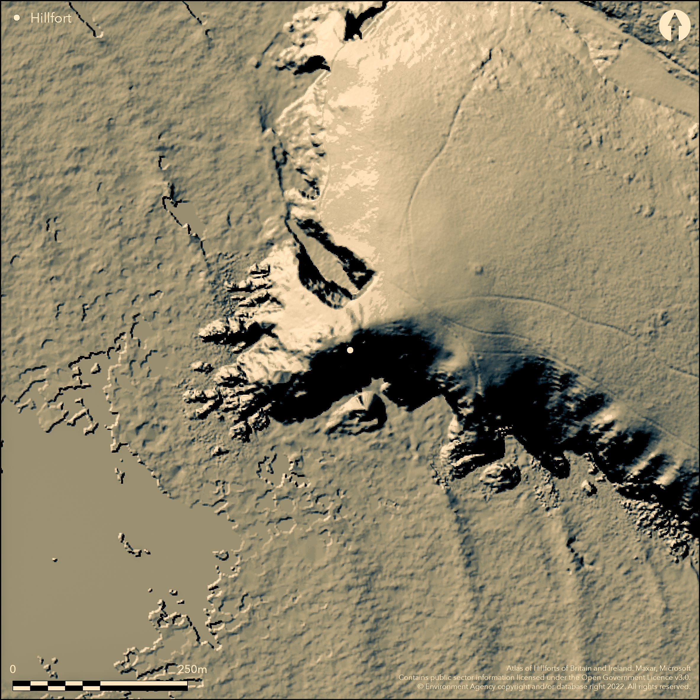
LiDAR 1m DTM Hillshade
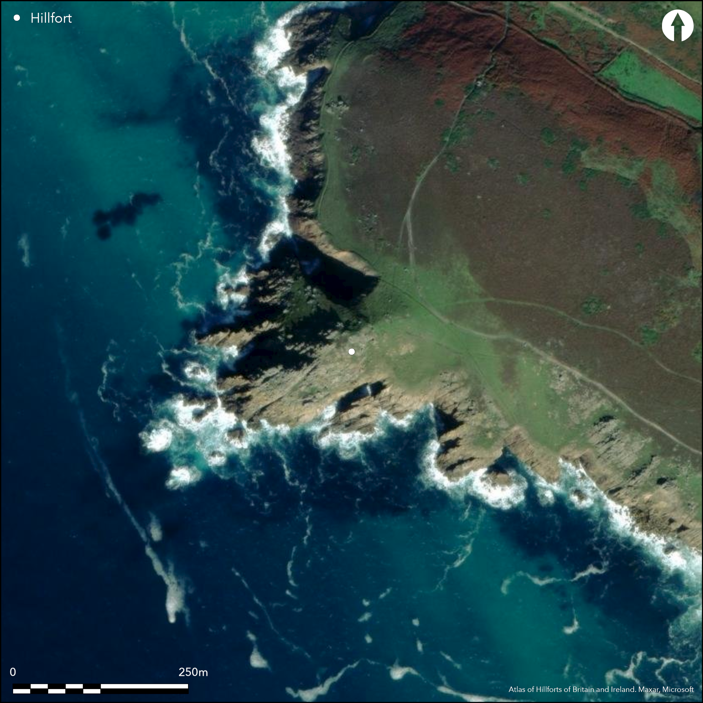
Satellite Imagery
LiDAR 1m DTM Hillshade
Satellite Imagery
Scroll left/right to view further images.
HER: Cornwall and Scilly MCO6535 (28278)
NMR: SW 32 SE 7 (421257)
SM: 1004293
NGR: SW 356 232
X: 135689 Y: 23236 (OSGB36)
Promontory fort sited on imposing, sloping, narrow and rocky, SW-facing granite coastal headland on promontory dividing Mill Bay or Nanizal and bay seaward of Higher Boristow Cliff, St Leven. Rocky promontory, c. 100m wide, but reducing and c. 200m long, ends in vertical sea cliffs on N, S, W and joined to mainland by narrow saddle of land on E where are ramparts, to N as two banks and ditches visible as massive ramparts, the inner 27m long, 8m wide and 1.2-2m high with ditch 0.9m deep and 4.5-5.4m wide, with smaller outer rampart 24m long and 3.6m wide, to 0.7m high, enclosing c. 0.5ha. This is fronted by outer ditch 0.6m deep and 2.4m wide. All are composed of earth and stone. To S of the line is a stony unditched bank, with natural outcrops, perhaps part of the original design. 30m to E of defences possible additional third earthen bank, 0.3m high and 1.8m wide, fronted by 0.4m deep and 1.8m wide ditch running from E side of Zarn Peggy inlet to top of coastal slope, thus cutting off N half of headland. Possibly forms outermost limits, but argued that are 19th century enclosure demarcations of the Higher Bosistow Cliff. Bank curves in towards two c. 2m long stones in centre of ridge, 2.5m apart, one recumbent to N, one standing to S, suggested as forming entrance, but this questioned. No hut platforms visible, but possible sites behind rampart where some shelter. Rocky coastal grassland. Generally dilapidated, but granite mitigates against erosion. On 1st Ed. OS map (1876). Undated.
Citizen Science: ✗
Reliability of Data: Confirmed
Reliability of Interpretation: Confirmed
X: -633817 Y: 6454998 (EPSG: 3857)
Longitude: -5.693677946093325 Latitude: 50.05033760478928 (EPSG:4326)
Country: England
Current County or Unitary Authority: Cornwall
Historic County: Cornwall
Current Parish/Community/Council/Townland: St Leven
Granite site mitigates against erosion, but generally dilapidated.
| Extant | ✓ |
| Cropmark | ✗ |
| Likely Destroyed | ✗ |
Rocky coastal grassland.
| Woodland | ✗ |
| Commercial Forestry Plantation | ✗ |
| Parkland | ✗ |
| Pasture (Grazing) | ✗ |
| Arable | ✗ |
| Scrub/Bracken | ✗ |
| Bare Outcrop | ✗ |
| Heather/Moorland | ✗ |
| Heath | ✗ |
| Built-up | ✗ |
| Coastal Grassland | ✓ |
| Other | ✗ |
Promontory fort (aka cliff castle) sited on imposing, sloping, narrow and rocky, SW-facing granite coastal headland, c. 100m wide but reducing and c. 200m long, on promontory dividing Mill Bay or Nanizal and bay seaward of Higher Boristow Cliff, St Leven.
| Contour Fort | ✗ |
| Partial Contour Fort | ✗ |
| Promontory Fort | ✓ |
| Hillslope Fort | ✗ |
| Level Terrain Fort | ✗ |
| Marsh Fort | ✗ |
| Multiple Enclosure Fort | ✗ |
Located on a steep and narrow granite headland with good views of Nanjizal Bay
| Hilltop | ✗ |
| Coastal Promontory | ✓ |
| Inland Promontory | ✗ |
| Valley Bottom | ✗ |
| Knoll/Hillock/Outcrop | ✗ |
| Ridge | ✗ |
| Cliff/Plateau-edge/Scarp | ✗ |
| Hillslope | ✗ |
| Lowland | ✗ |
| Spur | ✗ |
Dominant Topographic Feature: Rocky coastal headland.
| North | ✗ |
| Northeast | ✗ |
| East | ✗ |
| Southeast | ✗ |
| South | ✗ |
| Southwest | ✓ |
| West | ✗ |
| Northwest | ✗ |
| Level | ✗ |
Altitude: 50.0m
N/A
None.
Reliability: D - None
| Pre 1200BC | ✗ |
| 1200BC - 800BC | ✗ |
| 800BC - 400BC | ✗ |
| 400BC - AD50 | ✗ |
| AD50 - AD400 | ✗ |
| AD400 - AD 800 | ✗ |
| Post AD800 | ✗ |
| Unknown | ✓ |
| Pre Hillfort: | None |
| Post Hillfort: | None |
On 1st Ed. OS map (1876). Field investigation Ordnance Survey 1960. West Penwith Survey, Cornwall County Council 1971. Investigated by C. Weatherhill 1976. Surveyed by CAU 1995.
| 1st Identified Map Depiction (1876): | OS map. |
| Other (1960): | Field investigation OS. |
| Other (1971): | West Penwith Survey, Cornwall County Council. |
| Other (1976): | Investigated by C. Weatherhill. |
| Other (1995): | Surveyed by CAU. |
No hut platforms visible, but could be possible sites behind the earthen rampart where some shelter.
None
| None | ✓ |
| Spring | ✗ |
| Stream | ✗ |
| Pool | ✗ |
| Flush | ✗ |
| Well | ✗ |
| Other | ✗ |
No hut platforms visible, but could be possible sites behind the earthen rampart where some shelter.
| No Known Features | ✓ |
| Round Stone Structures | ✗ |
| Rectangular Stone Structures | ✗ |
| Curvilinear Platforms | ✗ |
| Other Roundhouse Evidence | ✗ |
| Pits | ✗ |
| Quarry Hollows | ✗ |
| Other | ✗ |
None
| No Known Excavation | ✓ |
| Pits | ✗ |
| Postholes | ✗ |
| Roundhouses | ✗ |
| Rectangular Structures | ✗ |
| Roads/Tracks | ✗ |
| Quarry Hollows | ✗ |
| Other | ✗ |
| Nothing Found | ✗ |
None
| No Known Geophysics | ✓ |
| Pits | ✗ |
| Roundhouses | ✗ |
| Rectangular Structures | ✗ |
| Roads/Tracks | ✗ |
| Quarry Hollows | ✗ |
| Other | ✗ |
| Nothing Found | ✗ |
None
| No Known Finds | ✓ |
| Pottery | ✗ |
| Metal | ✗ |
| Metalworking | ✗ |
| Human Bones | ✗ |
| Animal Bones | ✗ |
| Lithics | ✗ |
| Environmental | ✗ |
| Other | ✗ |
None
| APs Not Checked | ✓ |
| None | ✗ |
| Roundhouses | ✗ |
| Rectangular Structures | ✗ |
| Pits | ✗ |
| Postholes | ✗ |
| Roads/Tracks | ✗ |
| Other | ✗ |
Bank curves in towards two c. 2m long stones in centre of ridge, 2.5m apart, one recumbent to N, one standing to S, have been suggested as forming entrance, but this has also been questioned.
| 1: | None |
| 2: | Possible only - not determined. |
Guard Chambers: ✗
Chevaux de Frise: ✗
| 1. In-turned (North east): | Possibly inturned, but uncertain. |
The rocky promontory, c. 100m wide but reducing and c. 200m long, ends in vertical sea cliffs on N, S, W and joined to mainland by narrow saddle of land on E where are defences, to N as two banks and ditches visible as massive ramparts, the inner 27m long, 8m wide and 1.2-2m high with ditch 0.9m deep and 4.5-5.4m wide, with smaller outer rampart 24m long and 3.6m wide, t0 0.7m high. This is fronted by outer ditch 0.6m deep and 2.4m wide. All are composed of earth and stone. To the S of the line is a stony unditched bank, with natural outcrops, and this could have been utilised to complete the defence. 30m to E of defences possible additional third earthen bank 0.3m high x 1.8m wide fronted by 0.4m deep ands 1.8m wide ditch running from E side of Zarn Peggy inlet to top of the coastal slope, thus cutting off the N half of the headland. This may have formed the outermost defences, but it has been argued that they are 19th century enclosure demarcations of the Higher Bosistow Cliff.
| Area 1: | 0.5ha. |
| Total: | 0.5ha. |
Total Footprint Area: Noneha.
None
| ✗ | None |
| ✗ | None |
| NE Quadrant: | 3 |
| SE Quadrant: | 0 |
| SW Quadrant: | 0 |
| NW Quadrant: | 0 |
| Total: | 3 |
| Partial Univallate | ✗ |
| Univallate | ✗ |
| Partial Bivallate | ✗ |
| Bivallate | ✗ |
| Partial Multivallate | ✓ |
| Multivallate | ✗ |
| Unknown | ✗ |
| Partial Univallate | ✗ |
| Univallate | ✗ |
| Partial Bivallate | ✗ |
| Bivallate | ✗ |
| Partial Multivallate | ✗ |
| Multivallate | ✗ |
Earthen and stone banks incorporating rock in places.
| None | ✗ |
| Earthen Bank | ✓ |
| Stone Wall | ✗ |
| Rubble | ✓ |
| Wall-walk | ✗ |
| Evidence of Timber | ✗ |
| Vitrification | ✗ |
| Other Burning | ✗ |
| Palisade | ✗ |
| Counter Scarp Bank | ✗ |
| Berm | ✗ |
| Unfinished | ✗ |
| Other | ✗ |
None
| None | ✗ |
| Earthen Bank | ✗ |
| Stone Wall | ✗ |
| Murus Duplex | ✗ |
| Timber-framed | ✗ |
| Timber-laced | ✗ |
| Vitrification | ✗ |
| Other Burning | ✗ |
| Palisade | ✗ |
| Counter Scarp Bank | ✗ |
| Berm | ✗ |
| Unfinished | ✗ |
| No Known Excavation | ✓ |
| Other | ✗ |
| ✗ | None |
| ✓ | Wide ditches. |
Number of Ditches: 3
| ✗ | None |
Johnson, N. and Rose, P. 1982. Defended settlement in Cornwall - an illustrated discussion, In ed. D. Miles, The Romano-British countryside: Studies in rural settlement and economy, BAR Brit Ser 103, 151-207.
Russell, V. 1971. West Penwith Survey, Unpublished report, Cornwall County Council, 39.
Thomas, N. 1995. An Archaeological Assessment of Bosistow, Ardensawah and Roskestal Cliffs in St. Levan, Cornwall, Cornwall Event Report.
Atlas of Hillforts:
Wikidata:
This work is licensed under CC BY-SA 4.0![]()
![]()
![]() and should be cited as:
and should be cited as:
Lock, Gary and Ralston, Ian. 2024. Atlas of Hillforts of Britain and Ireland. Available at: https://hillforts.arch.ox.ac.uk
Document Version 1.1