LiDAR 1m DTM Hillshade
Satellite Imagery
LiDAR 1m DTM Hillshade
Satellite Imagery
Scroll left/right to view further images.
HER: Cornwall and Scilly MCO6545 (24047)
NMR: SX 03 NW 1 (431056)
SM: 1020865
NGR: SX00103985
X: 200100 Y: 39850 (OSGB36)
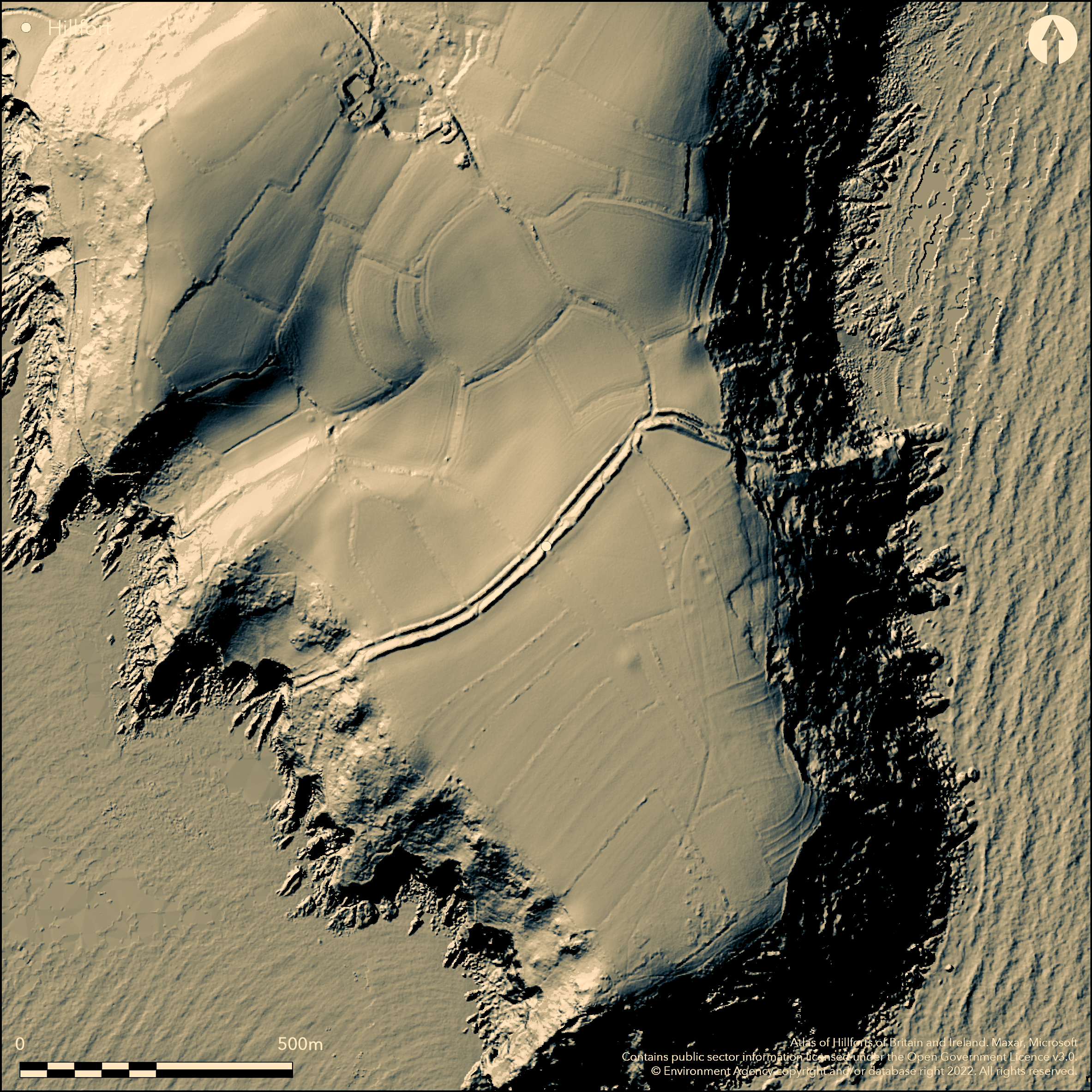
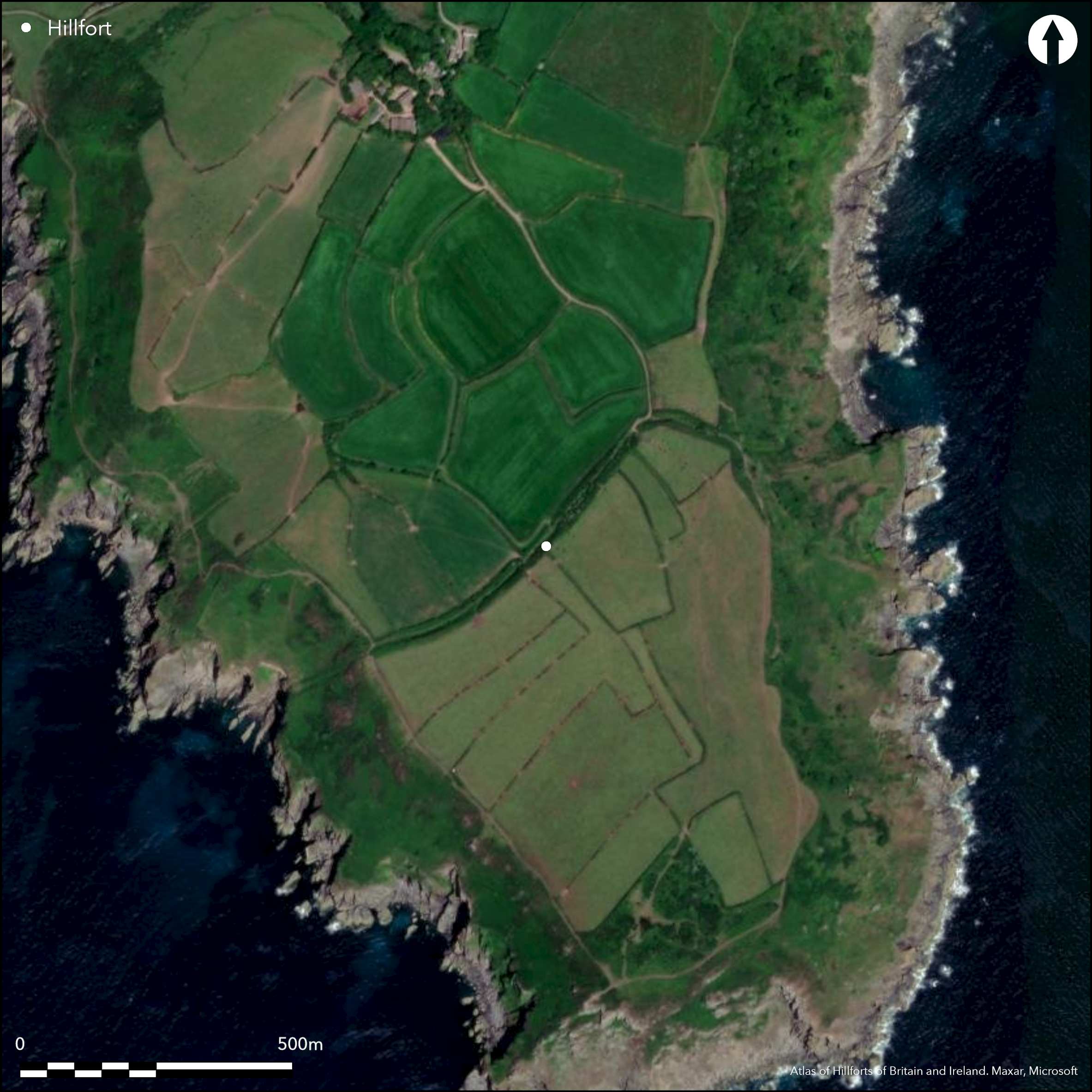
Large promontory fort sited on Dodman Point a prominent flat-topped headland projecting S into the English Channel, SW of Gorran Haven. Site irregular in plan, measuring to 830m N-S by 800m E-W, enclosing 21ha, externally of 34ha. Enclosed by two closely-spaced ramparts of earth and stone, c. 600m long and culminating in steep sea cliffs, with external ditches and counterscarp, all following slight natural slope around N edge of plateau on top of headland, continuing on steep coastal slopes below, incorporating outcrops of bedrock and (on E) natural rock walls and fissures. Ramparts steeply sloping sides and flat tops. Inner 7m-9m wide, its height up to 2m inside and 4m outside; outer, revetted, rampart c. 3.5-7m wide and c. 1.5m high. Both show reuse as field boundaries. Inner ditch, cut into bedrock, 4m-5m wide and 0.5m-2m deep. On W slope, outer ditch 4m wide and 0.7m deep. On plateau, ditch largely silted or filled by ploughing, but marked in places by hollows 2m-5m wide and 0.5m deep. Counterscarp visible to W as uneven, rounded bank c. 5m wide and to 1m high, possibly continuing across headland as buried feature. Numerous gaps, original and blocked entrance probably in the middle. Medieval or later trackway and beacon, medieval field system, Napoleonic signal station, Watch building, extractive pits, field system, boundary stones and granite shipping cross of 18th/19th centuries, two probable World War II bomb craters. Two large round barrows located in interior. Fort divided into cultivated fields, but, despite later developments, generally well-preserved. On 1st Ed. OS map (1881). Geophysics 2005, 2006, 2013. Undated.
Citizen Science: ✗
Reliability of Data: Confirmed
Reliability of Interpretation: Confirmed
X: -534770 Y: 6485285 (EPSG: 3857)
Longitude: -4.8039200358282 Latitude: 50.22472037806873 (EPSG:4326)
Country: England
Current County or Unitary Authority: Cornwall
Historic County: Cornwall
Current Parish/Community/Council/Townland: St Goran
Survives well despite partial burial of outer ditch and counterscarp and later constructions, coastal erosion and animal damage. Interior farmed. Signal station of 1794, watch house, granite cross of 1896 to SW - all for shipping. Also medieval or later trackway and beacon and medieval field system, another possible 18th/19th century building as earthwork. Extractive pits for stone, boundary walls and two possible WWII bomb craters. On Heritage at Risk Register (2015).
| Extant | ✓ |
| Cropmark | ✗ |
| Likely Destroyed | ✗ |
Interior split up into fields and farmed. Development in interior.
| Woodland | ✗ |
| Commercial Forestry Plantation | ✗ |
| Parkland | ✗ |
| Pasture (Grazing) | ✓ |
| Arable | ✓ |
| Scrub/Bracken | ✗ |
| Bare Outcrop | ✗ |
| Heather/Moorland | ✗ |
| Heath | ✗ |
| Built-up | ✓ |
| Coastal Grassland | ✓ |
| Other | ✓ |
Large promontory fort (aka cliff castle) sited on Dodman Point, prominent flat-topped headland projecting S into the English Channel, SW of Gorran Haven.
| Contour Fort | ✗ |
| Partial Contour Fort | ✗ |
| Promontory Fort | ✓ |
| Hillslope Fort | ✗ |
| Level Terrain Fort | ✗ |
| Marsh Fort | ✗ |
| Multiple Enclosure Fort | ✗ |
Coastal headland location and sea cliffs
| Hilltop | ✗ |
| Coastal Promontory | ✓ |
| Inland Promontory | ✗ |
| Valley Bottom | ✗ |
| Knoll/Hillock/Outcrop | ✗ |
| Ridge | ✗ |
| Cliff/Plateau-edge/Scarp | ✗ |
| Hillslope | ✗ |
| Lowland | ✗ |
| Spur | ✗ |
Dominant Topographic Feature: Flat-topped headland.
| North | ✗ |
| Northeast | ✗ |
| East | ✗ |
| Southeast | ✗ |
| South | ✗ |
| Southwest | ✗ |
| West | ✗ |
| Northwest | ✗ |
| Level | ✓ |
Altitude: 114.0m
N/A
No dating for the hillfort.
Reliability: D - None
| Pre 1200BC | ✗ |
| 1200BC - 800BC | ✗ |
| 800BC - 400BC | ✗ |
| 400BC - AD50 | ✗ |
| AD50 - AD400 | ✗ |
| AD400 - AD 800 | ✗ |
| Post AD800 | ✗ |
| Unknown | ✓ |
| Pre Hillfort: | Two large round barrows located in interior, one near centre, other towards N. |
| Post Hillfort: | Medieval or later trackway and beacon, medieval field system, Napoleonic signal station of 1794, watch house and granite shipping cross of 1896 to SW, all for shipping. Station reused in 1830's and WWI. Another possible 18th/19th century building as earthwork. Also extractive pits, field system, boundary stones and two probable World War II bomb craters. |
Shown on Edgecombe map of 1760. On 1st Ed. OS map (1881). Field investigation Ordnance Survey 1971. Geophysical surveys GSB Prospection Ltd 2004, 2005, 2006, 2013. Watching Briefs 2006, 2007. Plotted by NMP - no date.
| 1st Identified Map Depiction (1760): | Shown on Edgecombe map. |
| Other (1881): | OS map. |
| Other (1971): | Field investigation OS. |
| Geophysical Survey (None): | GSB Prospection Ltd. |
| Other (None): | Watching Briefs |
| Other (None): | Plotted by NMP. |
Two large round barrows located within interior, one near centre, other towards N. Both have earth and stone mounds, with no evidence of external ditches. They measure 22m in diameter and 0.9m high, and 27m NNW-SSE by 20m WSW-ENE and 1.3m high, respectively. The N barrow partly truncated on ENE by field boundary bank.Geophysics 2006, 2013 - no details. Few flints found in 2006 Watching Brief.
None
| None | ✓ |
| Spring | ✗ |
| Stream | ✗ |
| Pool | ✗ |
| Flush | ✗ |
| Well | ✗ |
| Other | ✗ |
Two large round barrows located within interior, one near centre, other towards N. Both have earth and stone mounds, with no evidence of external ditches. They measure 22m in diameter and 0.9m high, and 27m NNW-SSE by 20m WSW-ENE and 1.3m high, respectively. The N barrow partly truncated on ENE by field boundary bank.
| No Known Features | ✗ |
| Round Stone Structures | ✗ |
| Rectangular Stone Structures | ✗ |
| Curvilinear Platforms | ✗ |
| Other Roundhouse Evidence | ✗ |
| Pits | ✗ |
| Quarry Hollows | ✗ |
| Other | ✓ |
None
| No Known Excavation | ✓ |
| Pits | ✗ |
| Postholes | ✗ |
| Roundhouses | ✗ |
| Rectangular Structures | ✗ |
| Roads/Tracks | ✗ |
| Quarry Hollows | ✗ |
| Other | ✗ |
| Nothing Found | ✗ |
Geophysics 2005, 2006, 2013 - no details.
| No Known Geophysics | ✗ |
| Pits | ✗ |
| Roundhouses | ✗ |
| Rectangular Structures | ✗ |
| Roads/Tracks | ✗ |
| Quarry Hollows | ✗ |
| Other | ✓ |
| Nothing Found | ✗ |
Few flints found in 2006 Watching Brief.
| No Known Finds | ✗ |
| Pottery | ✗ |
| Metal | ✗ |
| Metalworking | ✗ |
| Human Bones | ✗ |
| Animal Bones | ✗ |
| Lithics | ✓ |
| Environmental | ✗ |
| Other | ✗ |
None
| APs Not Checked | ✓ |
| None | ✗ |
| Roundhouses | ✗ |
| Rectangular Structures | ✗ |
| Pits | ✗ |
| Postholes | ✗ |
| Roads/Tracks | ✗ |
| Other | ✗ |
Numerous gaps, the original and blocked entrance probably in the middle.
| None: | Numerous gaps. Total not defined. |
| 2: | None |
Guard Chambers: ✗
Chevaux de Frise: ✗
| 1. Blocked (South east): | Probably blocked. |
Enclosed by two closely-spaced ramparts of earth and stone, c. 600m long and culminating in steep sea cliffs, with external ditches and counterscarp, all following slight natural slope around the N edge of the plateau on top of headland, continuing on steep coastal slopes below, incorporating outcrops of bedrock and (on E) natural rock walls and fissures. Ramparts steeply sloping sides and flat tops. Inner 7m-9m wide, its height up to 2m inside and 4m outside. The outer, and revetted, rampart is 3.5m-7m wide and c. 1.5m high. Both show limited modification for reuse as field boundaries. The inner ditch, cut into bedrock, is 4m-5m wide and 0.5m-2m deep. On the W slope, outer ditch 4m wide and 0.7m deep. On plateau, ditch largely silted or filled by ploughing, but imarked in places by hollows 2m-5m wide and 0.5m deep. The counterscarp visible to the W as uneven, rounded bank c. 5m wide and to 1m high, possibly continuing across headland as a buried feature.
| Area 1: | 21.0ha. |
| Total: | 21.0ha. |
Total Footprint Area: 34.0ha.
None
| ✗ | None |
| ✗ | Two ramparts with counterscarp. |
| NE Quadrant: | 2 |
| SE Quadrant: | 0 |
| SW Quadrant: | 0 |
| NW Quadrant: | 2 |
| Total: | 2 |
| Partial Univallate | ✗ |
| Univallate | ✗ |
| Partial Bivallate | ✓ |
| Bivallate | ✗ |
| Partial Multivallate | ✗ |
| Multivallate | ✗ |
| Unknown | ✗ |
| Partial Univallate | ✗ |
| Univallate | ✗ |
| Partial Bivallate | ✗ |
| Bivallate | ✗ |
| Partial Multivallate | ✗ |
| Multivallate | ✗ |
Earth and stone. Outer rampart revetted. Counterscarp.
| None | ✗ |
| Earthen Bank | ✓ |
| Stone Wall | ✓ |
| Rubble | ✓ |
| Wall-walk | ✗ |
| Evidence of Timber | ✗ |
| Vitrification | ✗ |
| Other Burning | ✗ |
| Palisade | ✗ |
| Counter Scarp Bank | ✓ |
| Berm | ✗ |
| Unfinished | ✗ |
| Other | ✗ |
None
| None | ✗ |
| Earthen Bank | ✗ |
| Stone Wall | ✗ |
| Murus Duplex | ✗ |
| Timber-framed | ✗ |
| Timber-laced | ✗ |
| Vitrification | ✗ |
| Other Burning | ✗ |
| Palisade | ✗ |
| Counter Scarp Bank | ✗ |
| Berm | ✗ |
| Unfinished | ✗ |
| No Known Excavation | ✓ |
| Other | ✗ |
| ✗ | None |
| ✓ | Rock-cut inner ditch. Part buried outer ditch on plateau. |
Number of Ditches: 2
| ✗ | None |
Cotton, M.A. 1958-9. Cornish Cliff Castles, Proc West Cornwall Fld Club, 2, 3, 119.
Kirkham, G. 2005. The Dodman, Cornwall: archaeological watching brief on trenching for installation of a water supply, Unpublished Historic Environment Service Report No 2005R071, Truro.
Kirkham, G. 2006. The Dodman, Cornwall: archaeological watching brief on trenching for installation of a replacement lightning conductor, Unpublished Historic Environment Service Report No 06R005, Truro.
Kirkham, G. 2008. The Dodman, Cornwall: archaeological watching brief on trenching for installation of a water supply to the western side of the headland, Unpublished Historic Environment Service Report No 08R002, Truro.
Lysons, D. and Lysons, S. 1814. Magna Britannia. Vol 3, Cornwall, CCXLVI.
Page, W. ed. 1906. The Victoria History of the County of Cornwall, 1, London: James Street, 458-9.
Roseweare, M.J. and Roseweare, A.C.K. 2013. Dodman Point, Cornwall: geophysical survey, Unpublished survey report ArchaeoPhysica.
Stephens, C. 2005. Geophysical survey report Dodman Point II, Cornwall. GSB Prospection Ltd (survey reports).
Stephens, C. 2006. Geophysical survey report Dodman Point III. GSB Prospection Ltd (survey reports).
Warner, R.B. 1967. Some new cliff castles, Cornish Archaeol, 6, 111.
Atlas of Hillforts:
Wikidata:
This work is licensed under CC BY-SA 4.0![]()
![]()
![]() and should be cited as:
and should be cited as:
Lock, Gary and Ralston, Ian. 2024. Atlas of Hillforts of Britain and Ireland. Available at: https://hillforts.arch.ox.ac.uk
Document Version 1.1