LiDAR 1m DTM Hillshade
Satellite Imagery
LiDAR 1m DTM Hillshade
Satellite Imagery
Scroll left/right to view further images.
HER: Cornwall and Scilly MCO6555 (13017)
NMR: SW 71 NE 16 (426464)
SM: 1004328
NGR: SW 7556 1651
X: 175561 Y: 16513 (OSGB36)
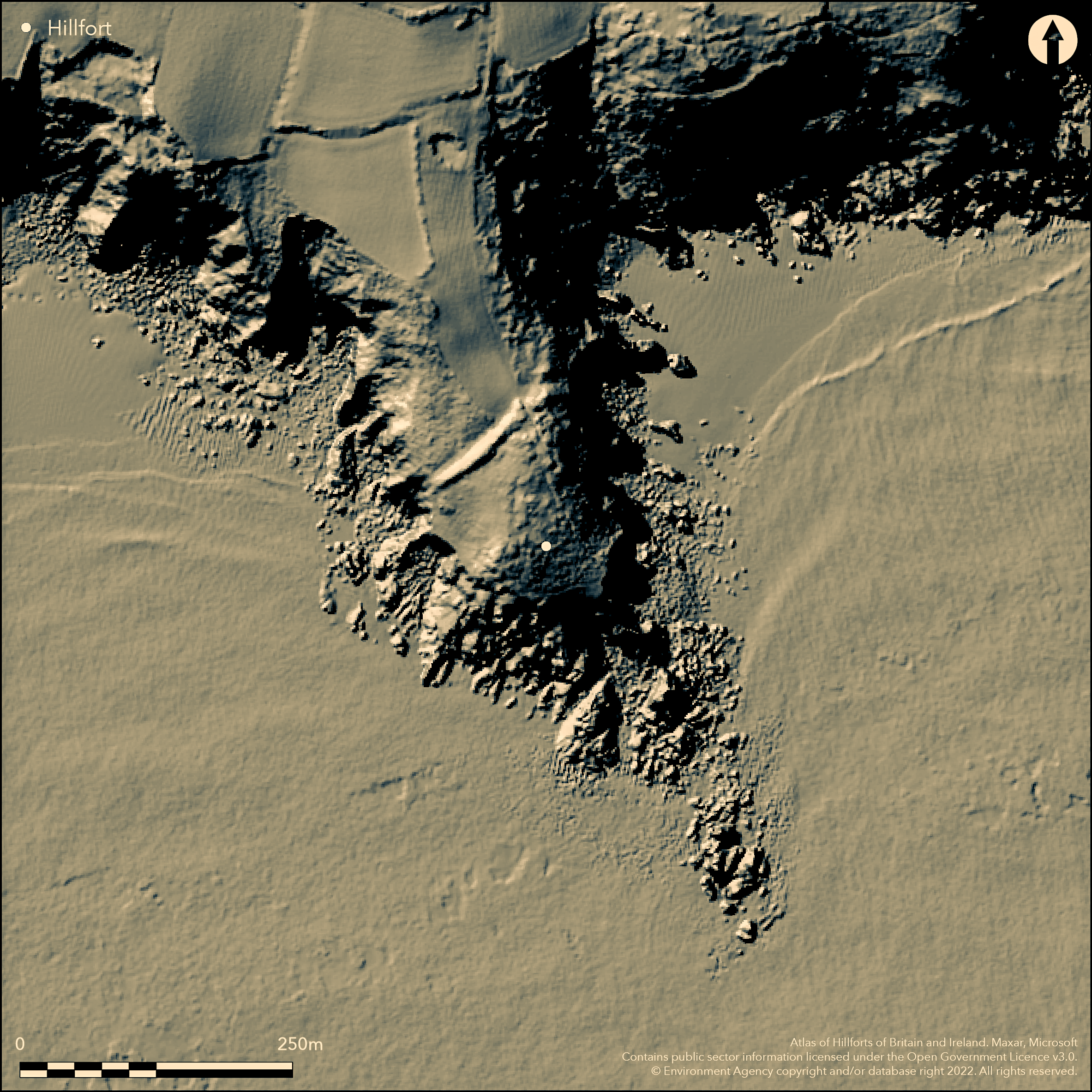
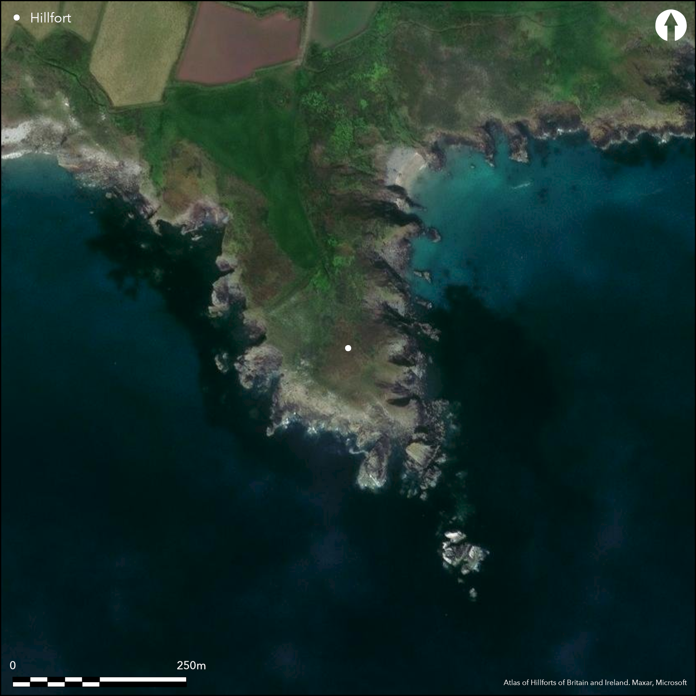
Univallate promontory fort sited on coastal headland of Linkidden, jutting S into Atlantic, which terminates to S in the rocks of Carrick Luz. Steep sea cliffs to E, S, W. Single earth and stone bank c. 100m long and up to 4.0m high with largely filled outer ditch c. 0.5m deep cuts off the landward N side of headland to form irregular enclosure culminating today in the Carrick Luz rocks, possibly joined to mainland and part of site in prehistory, enclosing 2.8ha. On E, rampart ends on edge of steep cliffs and affected by erosion, and on W terminal entirely lost to sea. Some doubt as to whether the track that passes through bank and into interior original. Gorse covered rampart, but good coastal grassland in interior, though site much affected by sea cliff erosion. On 1st Ed. OS map (1878-79). Undated.
Citizen Science: ✗
Reliability of Data: Confirmed
Reliability of Interpretation: Confirmed
X: -571482 Y: 6447374 (EPSG: 3857)
Longitude: -5.1337102067891465 Latitude: 50.00634299276194 (EPSG:4326)
Country: England
Current County or Unitary Authority: Cornwall
Historic County: Cornwall
Current Parish/Community/Council/Townland: St Keverne
Good condition coastal grassland with rampart gorse covered, but sea cliff erosion and W terminal of rampart lost.
| Extant | ✓ |
| Cropmark | ✗ |
| Likely Destroyed | ✓ |
Coastal, grassland with some scrub and bare rock.
| Woodland | ✗ |
| Commercial Forestry Plantation | ✗ |
| Parkland | ✗ |
| Pasture (Grazing) | ✗ |
| Arable | ✗ |
| Scrub/Bracken | ✓ |
| Bare Outcrop | ✗ |
| Heather/Moorland | ✗ |
| Heath | ✗ |
| Built-up | ✗ |
| Coastal Grassland | ✓ |
| Other | ✗ |
Univallate promontory fort (aka cliff castle) situated on coastal headland of Linkidden, jutting S into Atlantic, and which terminates to S in the rocks of Carrick Luz. Steep sea cliffs to E, S, W.
| Contour Fort | ✗ |
| Partial Contour Fort | ✗ |
| Promontory Fort | ✓ |
| Hillslope Fort | ✗ |
| Level Terrain Fort | ✗ |
| Marsh Fort | ✗ |
| Multiple Enclosure Fort | ✗ |
Coastal headland and sea cliffs
| Hilltop | ✗ |
| Coastal Promontory | ✓ |
| Inland Promontory | ✗ |
| Valley Bottom | ✗ |
| Knoll/Hillock/Outcrop | ✗ |
| Ridge | ✗ |
| Cliff/Plateau-edge/Scarp | ✗ |
| Hillslope | ✗ |
| Lowland | ✗ |
| Spur | ✗ |
Dominant Topographic Feature: Coastal headland
| North | ✗ |
| Northeast | ✗ |
| East | ✗ |
| Southeast | ✓ |
| South | ✗ |
| Southwest | ✗ |
| West | ✗ |
| Northwest | ✗ |
| Level | ✗ |
Altitude: 50.0m
N/A
None.
Reliability: D - None
| Pre 1200BC | ✗ |
| 1200BC - 800BC | ✗ |
| 800BC - 400BC | ✗ |
| 400BC - AD50 | ✗ |
| AD50 - AD400 | ✗ |
| AD400 - AD 800 | ✗ |
| Post AD800 | ✗ |
| Unknown | ✓ |
| Pre Hillfort: | None |
| Post Hillfort: | None |
First described by R. Thomas in newspaper 1851. On 1st Ed. OS map (1878-79). Field investigation Ordnance Survey 1973. Mapped by NMP - no date.
| 1st Identified Written Reference (1851): | First described by R. Thomas in newspaper. |
| Other (1973): | Field investigation OS. |
| 1st Identified Map Depiction (None): | OS map. |
| Other (None): | Mapped by NMP. |
Linear earth and stone bank plotted by NMP in interior.
None
| None | ✓ |
| Spring | ✗ |
| Stream | ✗ |
| Pool | ✗ |
| Flush | ✗ |
| Well | ✗ |
| Other | ✗ |
Linear earth and stone bank plotted by NMP in interior.
| No Known Features | ✗ |
| Round Stone Structures | ✗ |
| Rectangular Stone Structures | ✗ |
| Curvilinear Platforms | ✗ |
| Other Roundhouse Evidence | ✗ |
| Pits | ✗ |
| Quarry Hollows | ✗ |
| Other | ✓ |
None
| No Known Excavation | ✓ |
| Pits | ✗ |
| Postholes | ✗ |
| Roundhouses | ✗ |
| Rectangular Structures | ✗ |
| Roads/Tracks | ✗ |
| Quarry Hollows | ✗ |
| Other | ✗ |
| Nothing Found | ✗ |
None
| No Known Geophysics | ✓ |
| Pits | ✗ |
| Roundhouses | ✗ |
| Rectangular Structures | ✗ |
| Roads/Tracks | ✗ |
| Quarry Hollows | ✗ |
| Other | ✗ |
| Nothing Found | ✗ |
None
| No Known Finds | ✓ |
| Pottery | ✗ |
| Metal | ✗ |
| Metalworking | ✗ |
| Human Bones | ✗ |
| Animal Bones | ✗ |
| Lithics | ✗ |
| Environmental | ✗ |
| Other | ✗ |
None
| APs Not Checked | ✓ |
| None | ✗ |
| Roundhouses | ✗ |
| Rectangular Structures | ✗ |
| Pits | ✗ |
| Postholes | ✗ |
| Roads/Tracks | ✗ |
| Other | ✗ |
Some doubt as to whether the track that passes through the bank and into the interior of the site is original.
| 1: | Modern track passes through gap in bank. |
| 2: | None |
Guard Chambers: ✗
Chevaux de Frise: ✗
| 1. Simple Gap (East): | Uncertain. |
Single earth and stone bank c. 100m long and up to 4.0m high with largely filled outer ditch c. 0.5m deep cuts off the landward N side of headland to form an irregular enclosure culminating today in the Carrick Luz rocks, possibly joined to mainland and part of the site in prehistory. On E rampart ends on edge of the steep cliffs and affected by erosion, and on W terminal entirely lost to sea.
| Area 1: | 2.8ha. |
| Total: | 2.8ha. |
Total Footprint Area: Noneha.
None
| ✗ | None |
| ✗ | None |
| NE Quadrant: | 1 |
| SE Quadrant: | 0 |
| SW Quadrant: | 0 |
| NW Quadrant: | 1 |
| Total: | 1 |
| Partial Univallate | ✓ |
| Univallate | ✗ |
| Partial Bivallate | ✗ |
| Bivallate | ✗ |
| Partial Multivallate | ✗ |
| Multivallate | ✗ |
| Unknown | ✗ |
| Partial Univallate | ✗ |
| Univallate | ✗ |
| Partial Bivallate | ✗ |
| Bivallate | ✗ |
| Partial Multivallate | ✗ |
| Multivallate | ✗ |
Earth and stone bank.
| None | ✗ |
| Earthen Bank | ✓ |
| Stone Wall | ✗ |
| Rubble | ✓ |
| Wall-walk | ✗ |
| Evidence of Timber | ✗ |
| Vitrification | ✗ |
| Other Burning | ✗ |
| Palisade | ✗ |
| Counter Scarp Bank | ✗ |
| Berm | ✗ |
| Unfinished | ✗ |
| Other | ✗ |
None
| None | ✗ |
| Earthen Bank | ✗ |
| Stone Wall | ✗ |
| Murus Duplex | ✗ |
| Timber-framed | ✗ |
| Timber-laced | ✗ |
| Vitrification | ✗ |
| Other Burning | ✗ |
| Palisade | ✗ |
| Counter Scarp Bank | ✗ |
| Berm | ✗ |
| Unfinished | ✗ |
| No Known Excavation | ✓ |
| Other | ✗ |
| ✗ | None |
| ✓ | Ditch largely filled. |
Number of Ditches: 1
| ✗ | None |
Cotton, M.A. 1958-9. Cornish Cliff Castles, Proc West Cornwall Fld Club, 2, 3, 119.
Dowson, E. 1968. St Keverne parish check list, Cornish Archaeol, 7, 101-6.
Page, W. ed. 1906. The Victoria History of the County of Cornwall, 1, London: James Street, 453, 460.
Thomas, R. 1851. Letters to the West Briton, At CSL, Redruth, No 35.
Atlas of Hillforts:
Wikidata:
This work is licensed under CC BY-SA 4.0![]()
![]()
![]() and should be cited as:
and should be cited as:
Lock, Gary and Ralston, Ian. 2024. Atlas of Hillforts of Britain and Ireland. Available at: https://hillforts.arch.ox.ac.uk
Document Version 1.1