LiDAR 1m DTM Hillshade
Satellite Imagery
LiDAR 1m DTM Hillshade
Satellite Imagery
Scroll left/right to view further images.
HER: Staffordshire 00195-MST195 (None)
NMR: SO 88 SW 1 (116717)
SM: 1015432
NGR: SO 83594 83307
X: 383594 Y: 283307 (OSGB36)
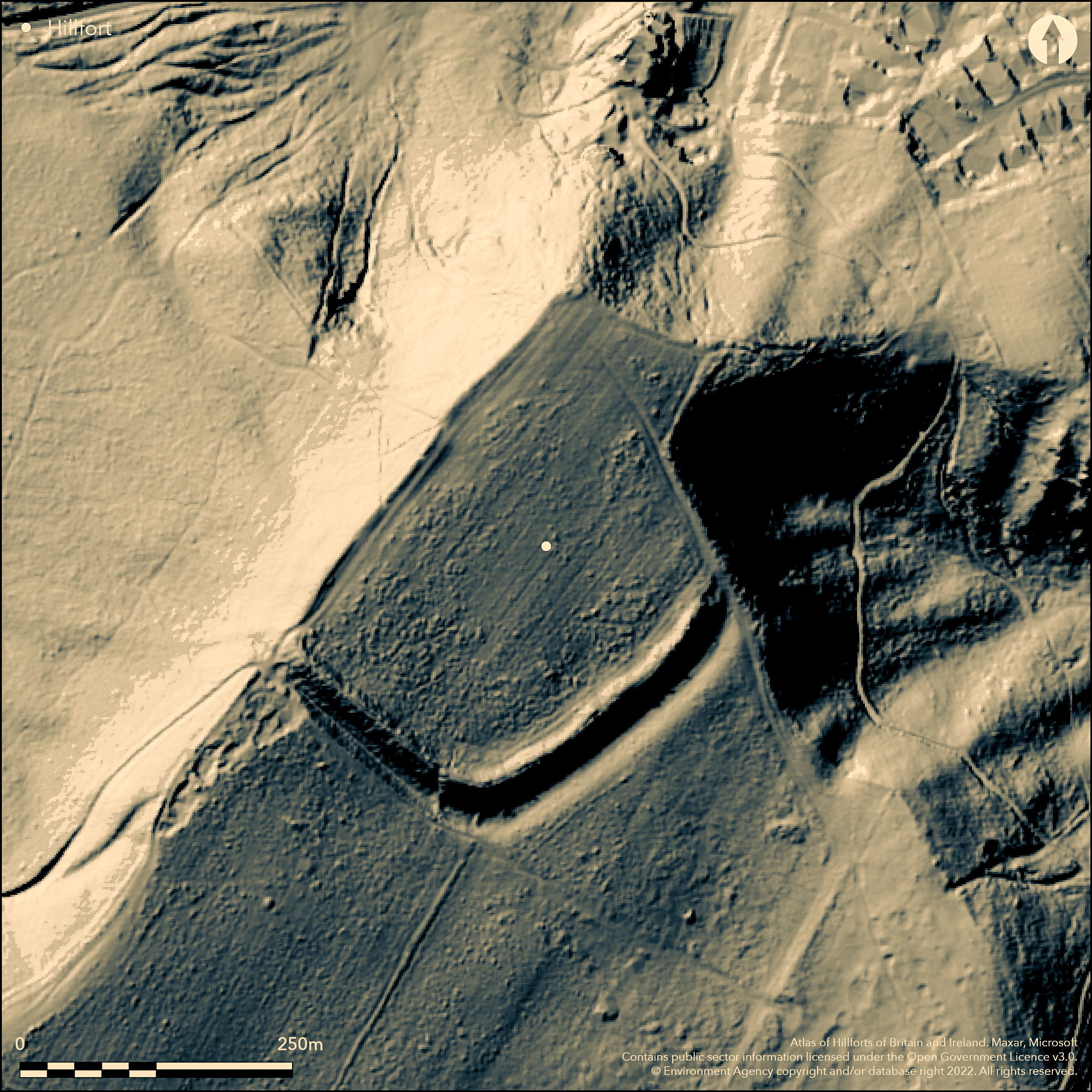
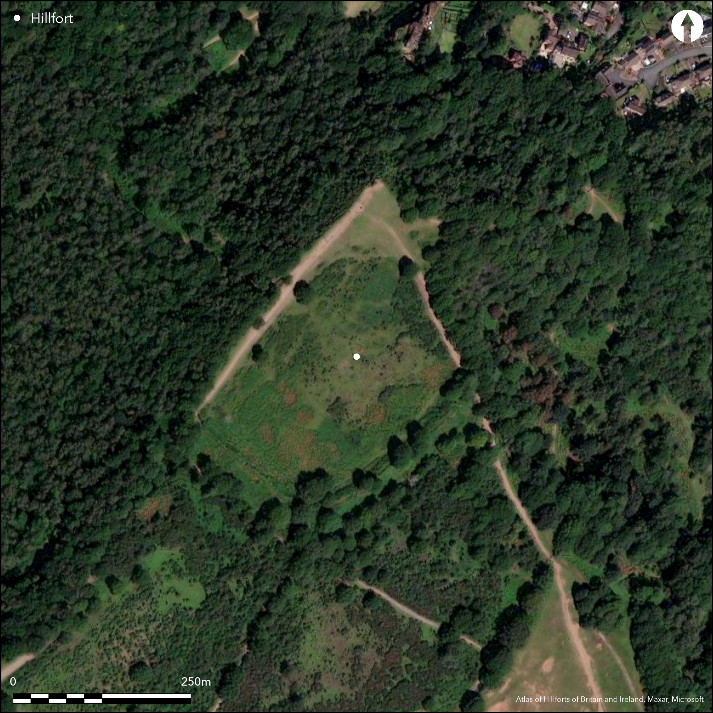
Lying to the SW of the village of Kinver at the NW corner of the highest point of the Kinver escarpment, a univallate promontory fort of 3.75ha. The site has a massive rampart with external ditch and counterscarp bank along the SW and SE sides, terminating at the edge of the escarpment, with the steep gradient of the escarpment forming the NW and NE sides, the whole defining a sub-rectangular area of 210m NW-SE and 300m transversely. The bank stands 8-9m high above the base of the ditch and 2-3.5m high internally, the counterscarp 3.5m high. The ditch is 24m wide but the NW and NE terminals have been lost through quarrying. Slight evidence exists on the NW and NE sides in the form of a low bank 0.7m high running parallel with the edge of the scarp for 170m in the NW and an earthwork in the NE, which is possibly original, although it has also been attributed to a field bank (Cocroft et al. 1988). A WWII home guard shelter has been terraced into the outside of the bank. The entrance is thought to lie at the NE end of the SE side where the earthwork terminates short of the steep natural slope, although quarrying has now obscured the area. A further possible entrance mid-way along the SE rampart and now blocked, was identified during the Staffordshire Hillforts Project (Cocroft et al. 1988). A low bank, which extends from the ditch in the NW extent for 100m to the W and curving to the N is a suggested elaborate entrance accessed by a holloway (ECUS Ltd. 2012). Shallow sub-circular features identified within the interior are possible tree throws or roundhouse terraces although ridge and furrow recorded within the interior has possibly truncated some features. Geophysical survey within the interior produced evidence for a possible roundhouse and in-situ burning or pit cluster and agricultural activity (Evans 2010). Recorded on 1883 OS mapping. Undated.
Citizen Science: ✗
Reliability of Data: Confirmed
Reliability of Interpretation: Confirmed
X: -249671 Y: 6881437 (EPSG: 3857)
Longitude: -2.2428296960471275 Latitude: 52.44744494222546 (EPSG:4326)
Country: England
Current County or Unitary Authority: Staffordshire
Historic County: Staffordshire
Current Parish/Community/Council/Townland: Kinver
National Trust HBSMR Ref. 52204
| Extant | ✓ |
| Cropmark | ✗ |
| Likely Destroyed | ✓ |
None
| Woodland | ✗ |
| Commercial Forestry Plantation | ✗ |
| Parkland | ✗ |
| Pasture (Grazing) | ✗ |
| Arable | ✗ |
| Scrub/Bracken | ✓ |
| Bare Outcrop | ✗ |
| Heather/Moorland | ✗ |
| Heath | ✗ |
| Built-up | ✗ |
| Coastal Grassland | ✗ |
| Other | ✗ |
A promontory fort lying at 155m OD on a S and S-easterly slope on the NW corner of the highest point of the Kinver escarpment
| Contour Fort | ✗ |
| Partial Contour Fort | ✗ |
| Promontory Fort | ✓ |
| Hillslope Fort | ✗ |
| Level Terrain Fort | ✗ |
| Marsh Fort | ✗ |
| Multiple Enclosure Fort | ✗ |
| Hilltop | ✗ |
| Coastal Promontory | ✗ |
| Inland Promontory | ✓ |
| Valley Bottom | ✗ |
| Knoll/Hillock/Outcrop | ✗ |
| Ridge | ✗ |
| Cliff/Plateau-edge/Scarp | ✓ |
| Hillslope | ✓ |
| Lowland | ✗ |
| Spur | ✗ |
Dominant Topographic Feature: Kinver escarpment
| North | ✗ |
| Northeast | ✗ |
| East | ✗ |
| Southeast | ✓ |
| South | ✓ |
| Southwest | ✗ |
| West | ✗ |
| Northwest | ✗ |
| Level | ✗ |
Altitude: 155.0m
N/A
The site is undated but probably Iron Age. WWII home guard shelter terraced into rampart. Ridge and furrow ploughing
Reliability: D - None
| Pre 1200BC | ✗ |
| 1200BC - 800BC | ✗ |
| 800BC - 400BC | ✗ |
| 400BC - AD50 | ✗ |
| AD50 - AD400 | ✗ |
| AD400 - AD 800 | ✗ |
| Post AD800 | ✗ |
| Unknown | ✓ |
| Pre Hillfort: | None |
| Post Hillfort: | None |
Recorded on 1883 1:2,500 OS mapping. described in Page (1909). Field investigation 1974. Recorded as part of the RCHME Staffordshire Hillforts Project (Cocroft et al. 1988), ref. no. 909579. Geophysical survey 2010. Scheduled
| 1st Identified Map Depiction (1883): | 1:2,500 |
| 1st Identified Written Reference (1909): | None |
| Other (1970): | Scheduled |
| Other (1974): | Field investigation |
| Earthwork Survey (1988): | None |
| Geophysical Survey (2010): | None |
Roundhouse and in-situ burning or pit cluster and agricultural activity by geophysics.
River Stour lies to the E
| None | ✓ |
| Spring | ✗ |
| Stream | ✗ |
| Pool | ✗ |
| Flush | ✗ |
| Well | ✗ |
| Other | ✗ |
None
| No Known Features | ✓ |
| Round Stone Structures | ✗ |
| Rectangular Stone Structures | ✗ |
| Curvilinear Platforms | ✗ |
| Other Roundhouse Evidence | ✗ |
| Pits | ✗ |
| Quarry Hollows | ✗ |
| Other | ✗ |
None
| No Known Excavation | ✓ |
| Pits | ✗ |
| Postholes | ✗ |
| Roundhouses | ✗ |
| Rectangular Structures | ✗ |
| Roads/Tracks | ✗ |
| Quarry Hollows | ✗ |
| Other | ✗ |
| Nothing Found | ✗ |
Agricultural activity
| No Known Geophysics | ✗ |
| Pits | ✓ |
| Roundhouses | ✓ |
| Rectangular Structures | ✗ |
| Roads/Tracks | ✗ |
| Quarry Hollows | ✗ |
| Other | ✓ |
| Nothing Found | ✗ |
None
| No Known Finds | ✓ |
| Pottery | ✗ |
| Metal | ✗ |
| Metalworking | ✗ |
| Human Bones | ✗ |
| Animal Bones | ✗ |
| Lithics | ✗ |
| Environmental | ✗ |
| Other | ✗ |
None
| APs Not Checked | ✓ |
| None | ✗ |
| Roundhouses | ✗ |
| Rectangular Structures | ✗ |
| Pits | ✗ |
| Postholes | ✗ |
| Roads/Tracks | ✗ |
| Other | ✗ |
The entrance is thought to lie at the north eastern end of the SE side although quarrying has now obscured the area. A further possible entrance mid-way along the SE rampart and now blocked, was identified during the Staffordshire Hillforts Project (Cocroft et al. 1988). A low bank, which extends from the ditch in the NW extent for 100m to the W and curving to the N is a suggested elaborate entrance accessed by a holloway (ECUS Ltd. 2012)
| 2: | None |
| 2: | None |
Guard Chambers: ✗
Chevaux de Frise: ✗
| 1. Simple Gap (South east): | None |
| 2. Simple Gap (South east): | Now blocked |
Promontory fort of 3.75ha. Defended by a massive rampart with external ditch and counterscarp bank along the SW and SE sides, terminating at the edge of the escarpment. Naturally defended in the NW and NE sides, the whole defining a sub-rectangular area of 210m NW-SE and 300m transversely. The bank stands 8-9m high above the base of the ditch and 2-3.5m high internally and the counterscarp 3.5m high. The ditch is 24m wide but the NW and NE terminals have been lost through quarrying. Slight evidence exists for defences along the NW and NE sides in the form of a low bank 0.7m high running parallel with the edge of the scarp for 170m in the NW and an earthwork in the NE, which is possibly original, although it has also been attributed to a field bank
| Area 1: | 3.75ha. |
| Total: | 3.75ha. |
Total Footprint Area: Noneha.
None
| ✗ | None |
| ✗ | None |
| NE Quadrant: | None |
| SE Quadrant: | 1 |
| SW Quadrant: | 1 |
| NW Quadrant: | None |
| Total: | 1 |
| Partial Univallate | ✓ |
| Univallate | ✗ |
| Partial Bivallate | ✗ |
| Bivallate | ✗ |
| Partial Multivallate | ✗ |
| Multivallate | ✗ |
| Unknown | ✗ |
| Partial Univallate | ✗ |
| Univallate | ✗ |
| Partial Bivallate | ✗ |
| Bivallate | ✗ |
| Partial Multivallate | ✗ |
| Multivallate | ✗ |
None
| None | ✗ |
| Earthen Bank | ✓ |
| Stone Wall | ✗ |
| Rubble | ✗ |
| Wall-walk | ✗ |
| Evidence of Timber | ✗ |
| Vitrification | ✗ |
| Other Burning | ✗ |
| Palisade | ✗ |
| Counter Scarp Bank | ✓ |
| Berm | ✗ |
| Unfinished | ✗ |
| Other | ✗ |
None
| None | ✗ |
| Earthen Bank | ✗ |
| Stone Wall | ✗ |
| Murus Duplex | ✗ |
| Timber-framed | ✗ |
| Timber-laced | ✗ |
| Vitrification | ✗ |
| Other Burning | ✗ |
| Palisade | ✗ |
| Counter Scarp Bank | ✗ |
| Berm | ✗ |
| Unfinished | ✗ |
| No Known Excavation | ✓ |
| Other | ✗ |
| ✗ | None |
| ✓ | None |
Number of Ditches: 1
| ✗ | None |
Cocroft, W., Jecock, M. and Johnston, D. 1988. Staffordshire Hillforts Project. RCHME
ECUS Ltd. 2012. Kinver Edge, Staffordshire: Historic Landscape Survey Report. Unpublished
Evans, M. 2010. Kinver Edge, Staffs: A Geophysical Survey of the interior of the Promontory Fort. University of Worcester. Unpublished.
Page, W. 1908. The Victoria History of the Counties of England. A History of the County of Stafford, Vol. I. 338-340
Atlas of Hillforts:
Wikidata:
This work is licensed under CC BY-SA 4.0![]()
![]()
![]() and should be cited as:
and should be cited as:
Lock, Gary and Ralston, Ian. 2024. Atlas of Hillforts of Britain and Ireland. Available at: https://hillforts.arch.ox.ac.uk
Document Version 1.1