LiDAR 1m DTM Hillshade

Satellite Imagery
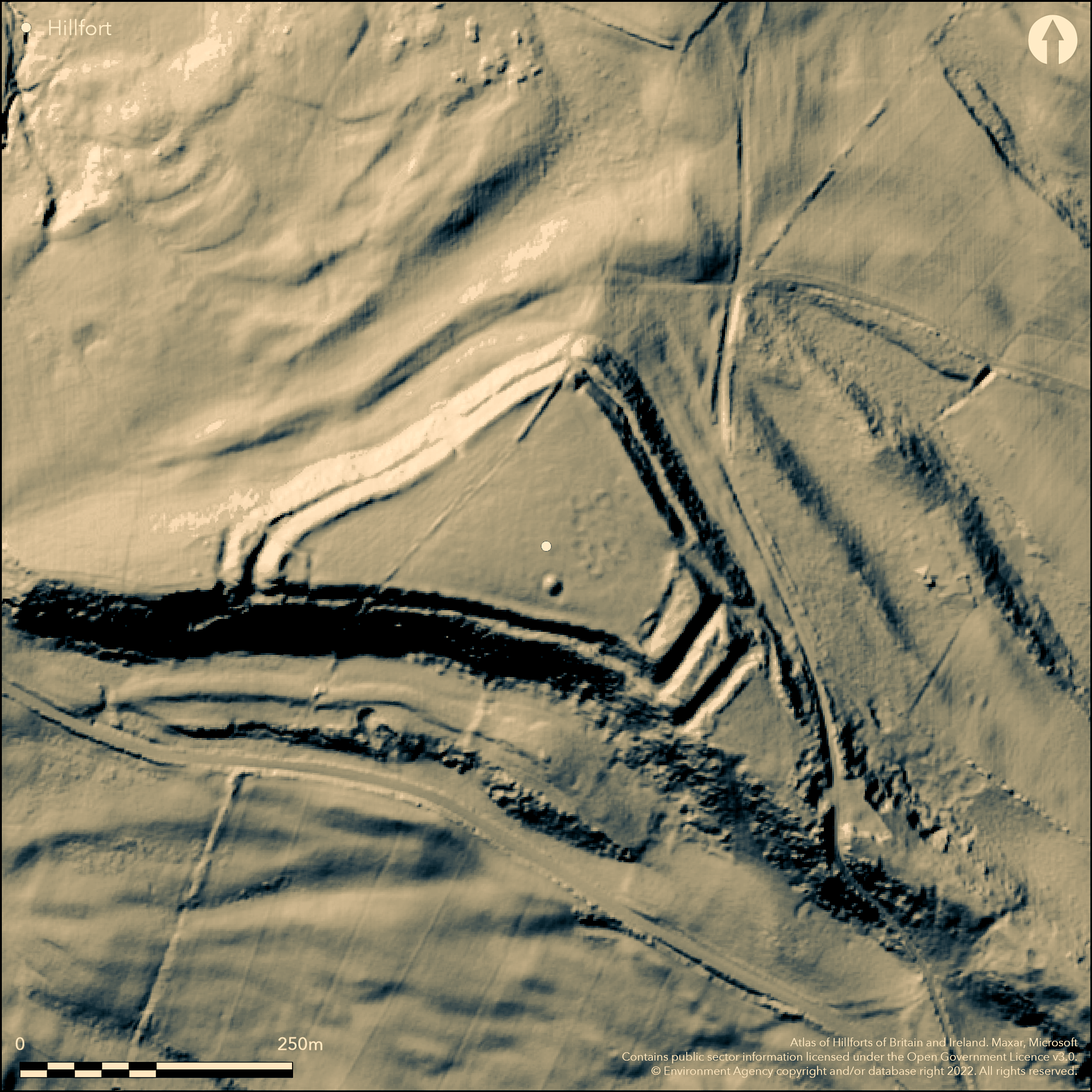
LiDAR 1m DTM Hillshade
Satellite Imagery
Scroll left/right to view further images.
HER: Dorset MDO24197 (None)
NMR: SY 58 NE 36 (450349)
SM: 1002710
NGR: SY55588657
X: 355591 Y: 86561 (OSGB36)
Commanding and mainly bivallate contour hillfort located on end of slight spur on the ridge of Wears Hill on Upper Greensand sandstones overlooking Chesil Beach and Portland. Developed from an earlier univallate hillfort. Moderate to strong surrounding slopes to N, E and W, strong generally to S, but less on SE. Commands extensive views and access along South Dorset Ridgeway. Triangular shape enclosing c. 4ha. Unusual shape governed by topography. Two ramparts, following the contours, with medial ditch. Probably phased construction. SE end strengthened by two additional banks with outer ditches, inner possibly original end of univallate enclosure, later superceded by new bank, obliterating ditch and with two new ditches. At SW, SE and, to lesser extent, N internal corners addition of internal mounds/enlargement of ramparts - unclear as to use. SW one suggested by RCHME (1952) as Roman signal post, but small excavation at the SW end 1974-75 found this not to be the case (Beavis 1974; 1976). Formerly complex, possibly inturned, entrance through banks on E approached by clear sloping passage. Probably disturbed by road and access into site. Number of circular hollows/platforms (at least ten) in interior thought to be roundhouse sites. Possible barrow shows as mound. Pasture and scrub/bracken interior, scrub on banks. Fair condition. South West Coast Path along S border of site. On 1st Ed. OS map (1889). Undated.
Citizen Science: ✓
Reliability of Data: Confirmed
Reliability of Interpretation: Confirmed
X: -292760 Y: 6564346 (EPSG: 3857)
Longitude: -2.629907659599981 Latitude: 50.676939919256874 (EPSG:4326)
Country: England; None
Current County or Unitary Authority: Dorset
Historic County: Dorset
Current Parish/Community/Council/Townland: Abbotsbury; Puncknowle
Fair condition despite some public access erosion.South West Coast Path along S border of site. Later wall NS across W end from entrance later parish boundary, wall, now much tumbled, cuts through S top rampart. On Heritage at Risk Register (2015).
| Extant | ✓ |
| Cropmark | ✗ |
| Likely Destroyed | ✗ |
Pasture and scrub/bracken interior, scrub on banks. SSSI.
| Woodland | ✗ |
| Commercial Forestry Plantation | ✗ |
| Parkland | ✗ |
| Pasture (Grazing) | ✓ |
| Arable | ✗ |
| Scrub/Bracken | ✓ |
| Bare Outcrop | ✗ |
| Heather/Moorland | ✗ |
| Heath | ✗ |
| Built-up | ✗ |
| Coastal Grassland | ✗ |
| Other | ✗ |
Commanding and mainly bivallate contour hillfort located on end of slight spur on the ridge of Wears Hill on Upper Greensand sandstones overlooking Chesil Beach and Portland. Developed from an earlier univallate hillfort. Moderate to strong surrounding slopes to N, E and W, strong generally to S, but less on SE. Commands extensive views and access along South Dorset Ridgeway. Plateau area c. 20m lower than hillfort around N and S sides, which fort overlooks. Slightly sloping to N. Unusual shape governed by topography.
| Contour Fort | ✓ |
| Partial Contour Fort | ✗ |
| Promontory Fort | ✗ |
| Hillslope Fort | ✗ |
| Level Terrain Fort | ✗ |
| Marsh Fort | ✗ |
| Multiple Enclosure Fort | ✗ |
| Hilltop | ✗ |
| Coastal Promontory | ✗ |
| Inland Promontory | ✗ |
| Valley Bottom | ✗ |
| Knoll/Hillock/Outcrop | ✗ |
| Ridge | ✓ |
| Cliff/Plateau-edge/Scarp | ✗ |
| Hillslope | ✗ |
| Lowland | ✗ |
| Spur | ✓ |
Dominant Topographic Feature: Spur on ridge
| North | ✓ |
| Northeast | ✗ |
| East | ✗ |
| Southeast | ✗ |
| South | ✗ |
| Southwest | ✗ |
| West | ✗ |
| Northwest | ✗ |
| Level | ✗ |
Altitude: 213.0m
Boundary Type: Parish/Townland
None.
Reliability: D - None
| Pre 1200BC | ✗ |
| 1200BC - 800BC | ✗ |
| 800BC - 400BC | ✗ |
| 400BC - AD50 | ✗ |
| AD50 - AD400 | ✗ |
| AD400 - AD 800 | ✗ |
| Post AD800 | ✗ |
| Unknown | ✓ |
| Pre Hillfort: | Interior has a fine barrow with ditch. |
| Post Hillfort: | Possible Roman and medieval activity, though Roman signal theory of small corner mound discounted by excavation. |
On 1st Ed. OS map (1889). Excavation at SW end by J. Beavis, Bournemouuth University. Visited by Hillfort Study Group 1966, 2016.
| 1st Identified Map Depiction (1889): | OS map. |
| Other (1966): | Visit by the Hillfort Study Group |
| Other (2016): | Visit by the Hillfort Study Group |
| Excavation (None): | J. Beavis, Bournemouuth University. |
Number of circular hollows/hut platforms in interior (at least ten) and especially in SE, c. 6m-7m diameter.
Wet patches in interior.
| None | ✗ |
| Spring | ✗ |
| Stream | ✗ |
| Pool | ✗ |
| Flush | ✗ |
| Well | ✗ |
| Other | ✓ |
Number of circular hollows/hut platforms in interior (at least ten) and especially in SE, c. 6m-7m diameter.
| No Known Features | ✗ |
| Round Stone Structures | ✗ |
| Rectangular Stone Structures | ✗ |
| Curvilinear Platforms | ✓ |
| Other Roundhouse Evidence | ✓ |
| Pits | ✗ |
| Quarry Hollows | ✗ |
| Other | ✗ |
SW corner mound investigated.
| No Known Excavation | ✗ |
| Pits | ✗ |
| Postholes | ✗ |
| Roundhouses | ✗ |
| Rectangular Structures | ✗ |
| Roads/Tracks | ✗ |
| Quarry Hollows | ✗ |
| Other | ✓ |
| Nothing Found | ✗ |
None
| No Known Geophysics | ✓ |
| Pits | ✗ |
| Roundhouses | ✗ |
| Rectangular Structures | ✗ |
| Roads/Tracks | ✗ |
| Quarry Hollows | ✗ |
| Other | ✗ |
| Nothing Found | ✗ |
None
| No Known Finds | ✓ |
| Pottery | ✗ |
| Metal | ✗ |
| Metalworking | ✗ |
| Human Bones | ✗ |
| Animal Bones | ✗ |
| Lithics | ✗ |
| Environmental | ✗ |
| Other | ✗ |
None
| APs Not Checked | ✓ |
| None | ✗ |
| Roundhouses | ✗ |
| Rectangular Structures | ✗ |
| Pits | ✗ |
| Postholes | ✗ |
| Roads/Tracks | ✗ |
| Other | ✗ |
Formerly complex, possibly inturned, entrance through banks on E approached by clear sloping passage. Probably disturbed by road and now entrance into site. Gaps on N and W modern.
| 3: | Gaps on N and W modern. |
| 2: | None |
Guard Chambers: ✗
Chevaux de Frise: ✗
| 1. In-turned (East): | Possibly inturned passageway. |
| 1. Passage-way/Corridor (East): | Clear sloping passage from road. Probably disturbed and now modern access into site. |
Defended by two ramparts, following the contours, with medial ditch. At SE end strengthened by two additional banks with outer ditches, inner possibly original end of univallate enclosure, later superceded by new bank, obliterating ditch and with two new ditches. At SW, SE and, to lesser extent, N corners addition of internal mounds/enlargement of ramparts - unclear as to use. W one suggested by RCHME (1952) as Roman signal post, but small excavation at the SW end 1974-75 found this not to be the case (Beavis 1974; 1976).
| Area 1: | 4.0ha. |
| Total: | 4.0ha. |
Total Footprint Area: Noneha.
None
| ✓ | Possibly phased, based on morphology of SE sector where ditch possibly part-filled with inner bank material. First phase possibly single bank and ditch enclosure. |
| ✓ | Four banks at SE end where topography levels out. |
| NE Quadrant: | 2 |
| SE Quadrant: | 4 |
| SW Quadrant: | 2 |
| NW Quadrant: | 2 |
| Total: | 4 |
| Partial Univallate | ✗ |
| Univallate | ✗ |
| Partial Bivallate | ✓ |
| Bivallate | ✗ |
| Partial Multivallate | ✓ |
| Multivallate | ✗ |
| Unknown | ✗ |
| Partial Univallate | ✗ |
| Univallate | ✓ |
| Partial Bivallate | ✗ |
| Bivallate | ✗ |
| Partial Multivallate | ✗ |
| Multivallate | ✗ |
At W, SE and, to lesser extent, N corners addition of internal mounds/enlargement of ramparts - unclear as to use.
| None | ✗ |
| Earthen Bank | ✓ |
| Stone Wall | ✗ |
| Rubble | ✗ |
| Wall-walk | ✗ |
| Evidence of Timber | ✗ |
| Vitrification | ✗ |
| Other Burning | ✗ |
| Palisade | ✗ |
| Counter Scarp Bank | ✗ |
| Berm | ✗ |
| Unfinished | ✗ |
| Other | ✓ |
SW corner mound suggested by RCHME (1952) as Roman signal post, but small excavation at the SW end 1974-75 found this not to be the case (Beavis 1974; 1976).
| None | ✗ |
| Earthen Bank | ✗ |
| Stone Wall | ✗ |
| Murus Duplex | ✗ |
| Timber-framed | ✗ |
| Timber-laced | ✗ |
| Vitrification | ✗ |
| Other Burning | ✗ |
| Palisade | ✗ |
| Counter Scarp Bank | ✗ |
| Berm | ✗ |
| Unfinished | ✗ |
| No Known Excavation | ✗ |
| Other | ✓ |
| ✗ | None |
| ✓ | Medial ditch except at SE end where four banks with outer ditches. |
Number of Ditches: 4
| ✗ | None |
Beavis, J. 1974. Excavations at Abbotsbury Castle, Proc Dorset Natur Hist Archaeol Soc, 96, 56.
Beavis, J. 1976. Interim note on excavations at Abbotsbury Castle hillfort, Proc Dorset Natur Hist Archaeol Soc, 97, 51.
Gale, J. 2003. Prehistoric Dorset, Stroud: Tempus Publishing.
RCHME 1952. An inventory of the historical monuments in Dorset, Vol 1, West Dorset, 10, No 31, London: RCHM.
Atlas of Hillforts:
Wikidata:
This work is licensed under CC BY-SA 4.0![]()
![]()
![]() and should be cited as:
and should be cited as:
Lock, Gary and Ralston, Ian. 2024. Atlas of Hillforts of Britain and Ireland. Available at: https://hillforts.arch.ox.ac.uk
Document Version 1.1