LiDAR 1m DTM Hillshade

Satellite Imagery
LiDAR 1m DTM Hillshade
Satellite Imagery
Scroll left/right to view further images.
HER: Dorset MDO6225 (None)
NMR: SZ 09 NE 44 (457812)
SM: 1003583
NGR: SZ077979
X: 407702 Y: 97918 (OSGB36)
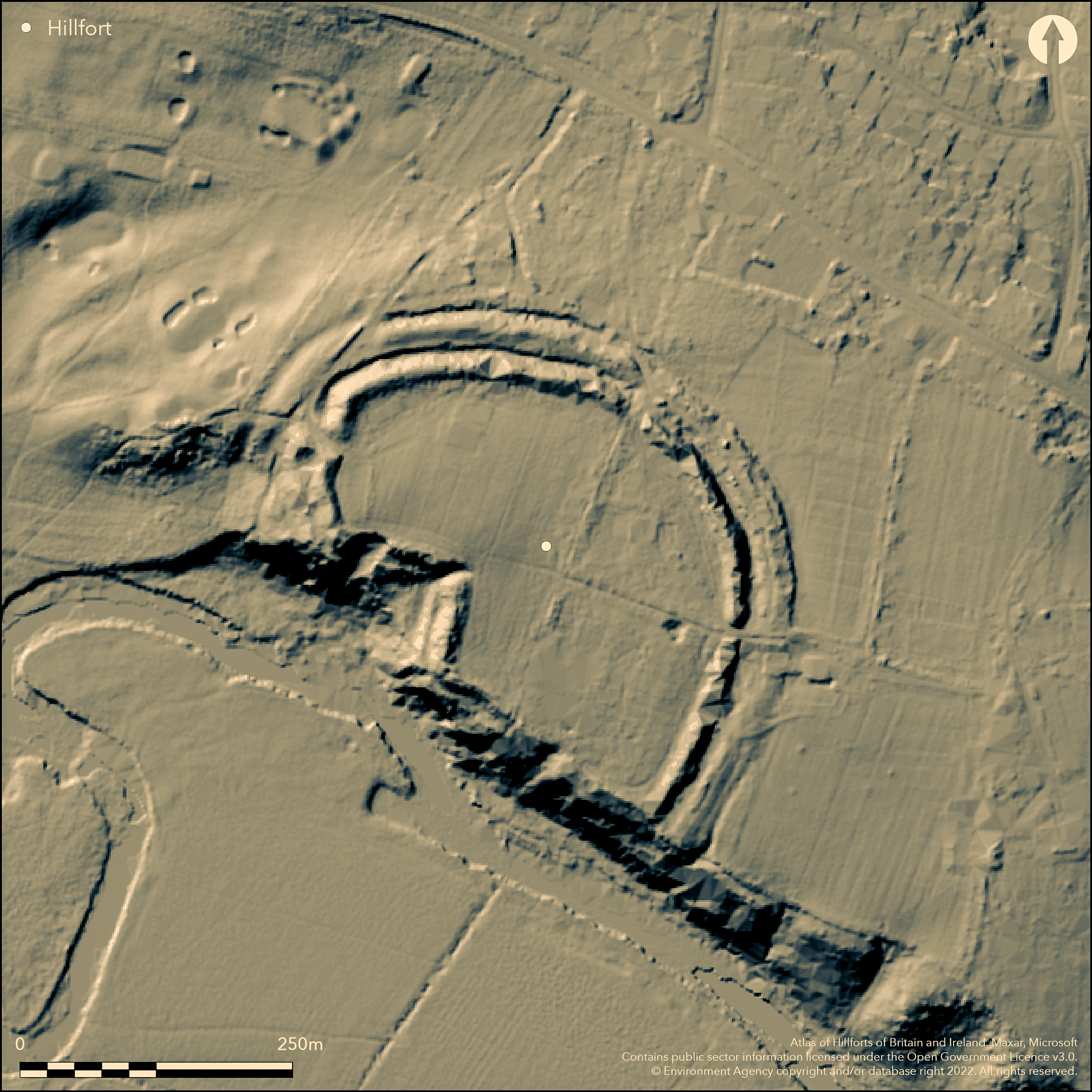
Prominent contour hillfort sited above the N bank of River Stour on S. Precipitous to river on S and SW, moderate slopes elsewhere. Semicircular and slightly domed with internal area 3.2ha. Defined by two ramparts and ditch on N, E and W, but much of outer rampart damaged or lost. Best just N of SW apex where inner rampart c. 4m above outer ditch bottom and outer rampart c. 5.8m above ditch bottom. Single rampart on SW c.4.9m above outer ledge or berm. Limited excavation by Heywood Sumner 1921 in W half of interior and across W entrance unproductive. Trench across inner ditch to NW side produced Iron Age sherds at ditch bottom. Four breaks, N and E probably modern, S and W possibly original that on W possibly in-turned. Interior under cultivation for many years except for NE quadrant where house and garden. On 1st Ed. OS map (1889).
Citizen Science: ✗
Reliability of Data: Confirmed
Reliability of Interpretation: Confirmed
X: -210632 Y: 6582598 (EPSG: 3857)
Longitude: -1.8921397322159497 Latitude: 50.780723777744825 (EPSG:4326)
Country: England; None
Current County or Unitary Authority: Dorset
Historic County: Dorset
Current Parish/Community/Council/Townland: Ferndown Town; Bournemouth
fair condition in part.
| Extant | ✓ |
| Cropmark | ✗ |
| Likely Destroyed | ✗ |
Interior under cultivation for many years except for NE quadrant where house and garden.
| Woodland | ✗ |
| Commercial Forestry Plantation | ✗ |
| Parkland | ✗ |
| Pasture (Grazing) | ✓ |
| Arable | ✗ |
| Scrub/Bracken | ✗ |
| Bare Outcrop | ✗ |
| Heather/Moorland | ✗ |
| Heath | ✗ |
| Built-up | ✓ |
| Coastal Grassland | ✗ |
| Other | ✗ |
Prominent contour hillfort sited above the N bank of River Stour on S. Precipitous to river on S and SW, moderate slopes elsewhere.
| Contour Fort | ✓ |
| Partial Contour Fort | ✗ |
| Promontory Fort | ✗ |
| Hillslope Fort | ✗ |
| Level Terrain Fort | ✗ |
| Marsh Fort | ✗ |
| Multiple Enclosure Fort | ✗ |
| Hilltop | ✓ |
| Coastal Promontory | ✗ |
| Inland Promontory | ✗ |
| Valley Bottom | ✗ |
| Knoll/Hillock/Outcrop | ✗ |
| Ridge | ✗ |
| Cliff/Plateau-edge/Scarp | ✗ |
| Hillslope | ✗ |
| Lowland | ✗ |
| Spur | ✗ |
Dominant Topographic Feature: Hill top
| North | ✗ |
| Northeast | ✗ |
| East | ✗ |
| Southeast | ✗ |
| South | ✗ |
| Southwest | ✗ |
| West | ✗ |
| Northwest | ✗ |
| Level | ✓ |
Altitude: 30.0m
Boundary Type: Parish/Townland
Trench across inner ditch to NW side produced Iron Age sherds at ditch bottom.
Reliability: B - Medium
| Pre 1200BC | ✗ |
| 1200BC - 800BC | ✗ |
| 800BC - 400BC | ✓ |
| 400BC - AD50 | ✓ |
| AD50 - AD400 | ✗ |
| AD400 - AD 800 | ✗ |
| Post AD800 | ✗ |
| Unknown | ✗ |
| Pre Hillfort: | None |
| Post Hillfort: | None |
| Artefactual: | None |
On 1st Ed. OS map (1889). Limited excavation by Heywood Sumner 1921, Evaluation AC Archaeology 1999. Watching Brief AC Archaeology 1999.
| 1st Identified Map Depiction (1889): | OS map. |
| Excavation (1921): | Heywood Sumner. |
| Other (1999): | Evaluation AC Archaeology. |
| Other (1999): | Watching Brief, AC Archaeology. |
Iron Age sherds at ditch bottom.
None
| None | ✓ |
| Spring | ✗ |
| Stream | ✗ |
| Pool | ✗ |
| Flush | ✗ |
| Well | ✗ |
| Other | ✗ |
None
| No Known Features | ✓ |
| Round Stone Structures | ✗ |
| Rectangular Stone Structures | ✗ |
| Curvilinear Platforms | ✗ |
| Other Roundhouse Evidence | ✗ |
| Pits | ✗ |
| Quarry Hollows | ✗ |
| Other | ✗ |
None
| No Known Excavation | ✗ |
| Pits | ✗ |
| Postholes | ✗ |
| Roundhouses | ✗ |
| Rectangular Structures | ✗ |
| Roads/Tracks | ✗ |
| Quarry Hollows | ✗ |
| Other | ✗ |
| Nothing Found | ✓ |
None
| No Known Geophysics | ✓ |
| Pits | ✗ |
| Roundhouses | ✗ |
| Rectangular Structures | ✗ |
| Roads/Tracks | ✗ |
| Quarry Hollows | ✗ |
| Other | ✗ |
| Nothing Found | ✗ |
Iron Age sherds at ditch bottom.
| No Known Finds | ✗ |
| Pottery | ✓ |
| Metal | ✗ |
| Metalworking | ✗ |
| Human Bones | ✗ |
| Animal Bones | ✗ |
| Lithics | ✗ |
| Environmental | ✗ |
| Other | ✗ |
None
| APs Not Checked | ✓ |
| None | ✗ |
| Roundhouses | ✗ |
| Rectangular Structures | ✗ |
| Pits | ✗ |
| Postholes | ✗ |
| Roads/Tracks | ✗ |
| Other | ✗ |
Four gaps, N and E probably modern, S and W possibly original, that on W possibly inturned.
| 4: | N and E probalby modern. |
| 2: | None |
Guard Chambers: ✗
Chevaux de Frise: ✗
| 1. Simple Gap (South): | Possibly original. |
| 2. In-turned (West): | Possibly original. |
Defined by two ramparts and ditch on N, E and W, but much of outer rampart damaged or lost. Best just N of SW apex where inner rampart c. 4m above outer ditch bottom and outer rampart c. 5.8m above ditch bottom. Single rampart on SW c.4.9m above outer ledge or berm.
| Area 1: | 3.2ha. |
| Total: | 3.2ha. |
Total Footprint Area: Noneha.
None
| ✗ | None |
| ✗ | None |
| NE Quadrant: | 2 |
| SE Quadrant: | None |
| SW Quadrant: | None |
| NW Quadrant: | 2 |
| Total: | 2 |
| Partial Univallate | ✗ |
| Univallate | ✗ |
| Partial Bivallate | ✓ |
| Bivallate | ✗ |
| Partial Multivallate | ✗ |
| Multivallate | ✗ |
| Unknown | ✗ |
| Partial Univallate | ✗ |
| Univallate | ✗ |
| Partial Bivallate | ✗ |
| Bivallate | ✗ |
| Partial Multivallate | ✗ |
| Multivallate | ✗ |
Outer ledge or berm on SE
| None | ✗ |
| Earthen Bank | ✓ |
| Stone Wall | ✗ |
| Rubble | ✗ |
| Wall-walk | ✗ |
| Evidence of Timber | ✗ |
| Vitrification | ✗ |
| Other Burning | ✗ |
| Palisade | ✗ |
| Counter Scarp Bank | ✗ |
| Berm | ✓ |
| Unfinished | ✗ |
| Other | ✗ |
None
| None | ✓ |
| Earthen Bank | ✗ |
| Stone Wall | ✗ |
| Murus Duplex | ✗ |
| Timber-framed | ✗ |
| Timber-laced | ✗ |
| Vitrification | ✗ |
| Other Burning | ✗ |
| Palisade | ✗ |
| Counter Scarp Bank | ✗ |
| Berm | ✗ |
| Unfinished | ✗ |
| No Known Excavation | ✗ |
| Other | ✗ |
| ✗ | None |
| ✓ | None |
Number of Ditches: 2
| ✗ | None |
Allcroft, H. 1908. Earthworks of England, 191.
Gale, J. 2003. Prehistoric Dorset, Stroud: Tempus Publishing.
RCHME 1975. An inventory of the historical monuments in Dorset, Vol 5, East Dorset, 76-7, London: RCHME.
Warne, C. 1872. Ancient Dorset. The Celtic, Roman, Saxon and Danish Antiquities of the County, Bournemouth: For the author, 53-5.
Atlas of Hillforts:
Wikidata:
This work is licensed under CC BY-SA 4.0![]()
![]()
![]() and should be cited as:
and should be cited as:
Lock, Gary and Ralston, Ian. 2024. Atlas of Hillforts of Britain and Ireland. Available at: https://hillforts.arch.ox.ac.uk
Document Version 1.1