LiDAR 1m DTM Hillshade
Satellite Imagery
LiDAR 1m DTM Hillshade
Satellite Imagery
Scroll left/right to view further images.
HER: Dorset MDO2018 (None)
NMR: ST 40 SW 9 (193083)
SM: 1019394
NGR: ST41270127
X: 341253 Y: 101308 (OSGB36)
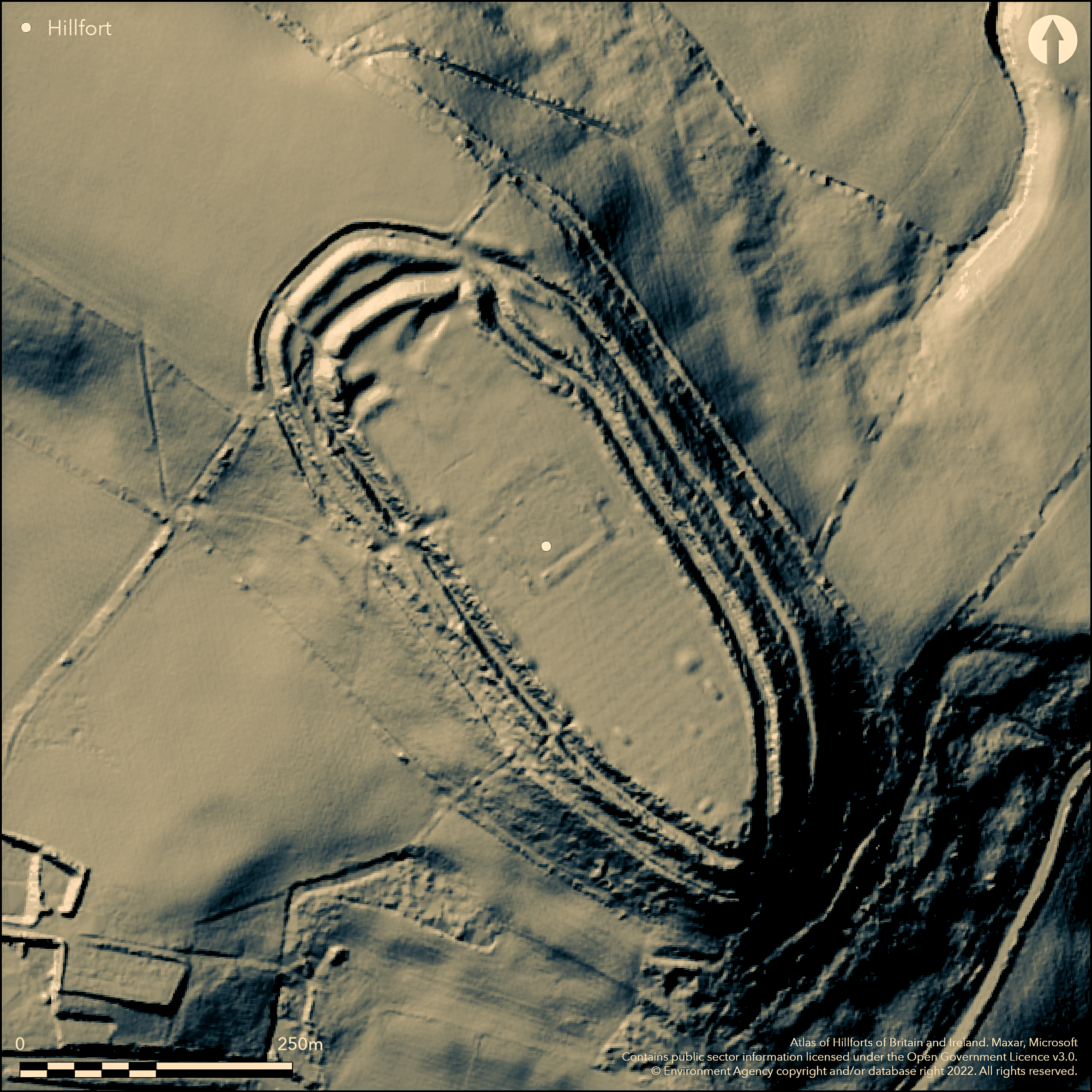
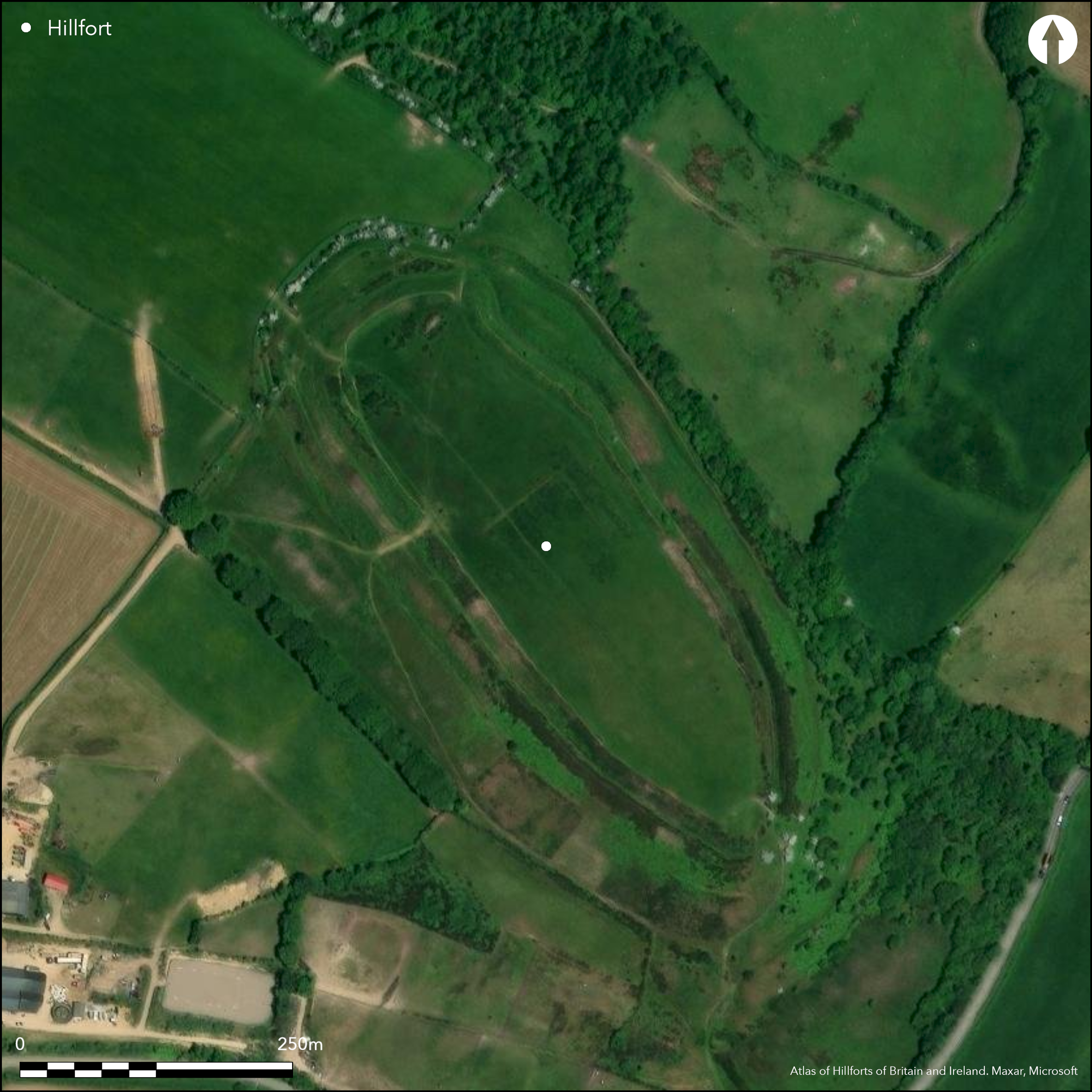
Highest of Dorset hillforts at 277m O.D., multivallate, contour hillfort located the end of a spur overlooking W end of Marshwood Vale, 7km W of Beaminster; one of four hillforts in the area. Irregular shaped oval enclosing c. 3.2ha. Naturally steep surrounding slopes utilised on all but NW side where approach c. level. Defined by two massive banks and ditches with small counterscarp, where slope is less steep or interval between inner and outer ramparts. Inner rampart absent in places. Inner and outer ditches mutilated by hedge banks on NE and SW respectively. Near middle of fort square enclosure surrounded by slight bank c. 7.6m wide with traces of external ditch, now thought no older than 17th century; adjacent is possible long barrow. SW bank destroyed by pillow-mound. Four entrance gaps. That on SE has outer bank stopping short of gate to provide oblique entry and appears to be original; that on SW platform between the ramparts on its S flank possibly also. Of the two entrances on N end that on NW probably modern, but that on NE possibly original and masked by a convergence of the ramparts. Excavation by P.S. Gelling 1964-71 (Gelling 1977). Three areas investigated. First on NW remains of abortive ramparts never completed, with central entrance, double rampart and ditch 1.8m deep, possibly first attempt at construction. Small Roman sherd was found near gate. Second area to S where two typical Iron Age round huts excavated. Finds included domestic refuse, fragments of crucible to which were adhering minute specks of gold. Finally, and contentiously, in square area in centre of site (see above), Gelling interpreted a rectilinear timber structure, with two associated huts, one containing a Gallo-Belgic XV gold coin, as a temple in operation c. 80 BC to 40 BC, later replaced by low banks and a token demarcation of a temenos area. However, in a re-working of the excavation in 1982 by D.W.R. Thackray the temenos was considered a much later feature and possibly part of the medieval rabbit warren. Generally well-preserved, but on SW bank destroyed by pillow-mound and ditches mutilated in places. Owned and managed by National Trust. On 1st Ed. OS map (1889).
Citizen Science: ✓
Reliability of Data: Confirmed
Reliability of Interpretation: Confirmed
X: -315610 Y: 6587449 (EPSG: 3857)
Longitude: -2.835169726801072 Latitude: 50.80826983803195 (EPSG:4326)
Country: England; None
Current County or Unitary Authority: Dorset
Historic County: Dorset
Current Parish/Community/Council/Townland: Pilsdon; Burstock
Generally well-preserved, but on SW bank destroyed by pillow-mound and inner and outer ditches mutilated by hedgebanks on NE and SW respectively. Owned and managed by National Trust.
| Extant | ✓ |
| Cropmark | ✗ |
| Likely Destroyed | ✗ |
Pasture interior, scrub/trees on banks and slopes NE-SE. Scrub on W banks.
| Woodland | ✗ |
| Commercial Forestry Plantation | ✗ |
| Parkland | ✗ |
| Pasture (Grazing) | ✓ |
| Arable | ✗ |
| Scrub/Bracken | ✓ |
| Bare Outcrop | ✗ |
| Heather/Moorland | ✗ |
| Heath | ✗ |
| Built-up | ✗ |
| Coastal Grassland | ✗ |
| Other | ✗ |
Highest of Dorset hillforts at 277m O.D., commanding, multivallate, contour hillfort located the end of a spur overlooking W end of Marshwood Vale. Steep surrounding slopes.
| Contour Fort | ✓ |
| Partial Contour Fort | ✗ |
| Promontory Fort | ✗ |
| Hillslope Fort | ✗ |
| Level Terrain Fort | ✗ |
| Marsh Fort | ✗ |
| Multiple Enclosure Fort | ✗ |
| Hilltop | ✗ |
| Coastal Promontory | ✗ |
| Inland Promontory | ✗ |
| Valley Bottom | ✗ |
| Knoll/Hillock/Outcrop | ✗ |
| Ridge | ✗ |
| Cliff/Plateau-edge/Scarp | ✗ |
| Hillslope | ✗ |
| Lowland | ✗ |
| Spur | ✓ |
Dominant Topographic Feature: Spur
| North | ✗ |
| Northeast | ✗ |
| East | ✗ |
| Southeast | ✗ |
| South | ✗ |
| Southwest | ✗ |
| West | ✗ |
| Northwest | ✗ |
| Level | ✓ |
Altitude: 277.0m
Boundary Type: Parish/Townland
Probably Iron Age. Ceramics of mainly middle Iron Age South-Western decorated form, but later bead-rimmed plain wares also. Coin of Gallo-Belgic XV found.
Reliability: B - Medium
| Pre 1200BC | ✗ |
| 1200BC - 800BC | ✗ |
| 800BC - 400BC | ✗ |
| 400BC - AD50 | ✓ |
| AD50 - AD400 | ✓ |
| AD400 - AD 800 | ✗ |
| Post AD800 | ✗ |
| Unknown | ✗ |
| Pre Hillfort: | None |
| Post Hillfort: | None |
| Artefactual: | Ceramics of mainly middle Iron Age South-Western decorated form, but later bead-rimmed plain wares also. Coin of Gallo-Belgic XV found. |
On 1st Ed. OS map (1889). Excavation P.S. Gelling 1964-71. Excavation D.W.R. Thackray 1982. Measured survey RCHME 1995, ref. no. 1007320. Geophysical survey National Trust 1999. Visited by Hillfort Study Group 1966.
| 1st Identified Map Depiction (1889): | OS map. |
| Other (1966): | Visit by the Hillfort Study Group |
| Excavation (1982): | D.W.R. Thackray. |
| Earthwork Survey (1995): | Measured survey RCHME. |
| Geophysical Survey (1999): | Resistivity survey National Trust, M. Papworth. |
| Excavation (None): | P.S. Gelling. |
Roundhouses and rectilinear structure excavated by Gelling. Series of pillow mounds in interior relate to medieval rabbit warren. Ceramics of mainly South-Western decorated form. Roman ballista bolt. 1,000 slingstones in pit in square enclosure. Evidence of gold working.
None
| None | ✓ |
| Spring | ✗ |
| Stream | ✗ |
| Pool | ✗ |
| Flush | ✗ |
| Well | ✗ |
| Other | ✗ |
Hollows possible roundhouse sites. Series of pillow mounds in interior relate to medieval rabbit warren.
| No Known Features | ✗ |
| Round Stone Structures | ✗ |
| Rectangular Stone Structures | ✗ |
| Curvilinear Platforms | ✗ |
| Other Roundhouse Evidence | ✓ |
| Pits | ✗ |
| Quarry Hollows | ✗ |
| Other | ✗ |
Roundhouses and rectilinear structure excavated by Gelling. Metalled roadway found. Pits.
| No Known Excavation | ✗ |
| Pits | ✓ |
| Postholes | ✓ |
| Roundhouses | ✓ |
| Rectangular Structures | ✓ |
| Roads/Tracks | ✓ |
| Quarry Hollows | ✗ |
| Other | ✗ |
| Nothing Found | ✗ |
Later geophysical survey 1991 - no details.
| No Known Geophysics | ✗ |
| Pits | ✗ |
| Roundhouses | ✗ |
| Rectangular Structures | ✗ |
| Roads/Tracks | ✗ |
| Quarry Hollows | ✗ |
| Other | ✓ |
| Nothing Found | ✗ |
Ceramics of mainly middle Iron Age South-Western decorated form, but later bead-rimmed plain wars also. Roman ballista bolt. 1,000 slingstones in pit in square enclosure. Evidence of gold working.
| No Known Finds | ✗ |
| Pottery | ✓ |
| Metal | ✓ |
| Metalworking | ✓ |
| Human Bones | ✗ |
| Animal Bones | ✗ |
| Lithics | ✓ |
| Environmental | ✗ |
| Other | ✗ |
None
| APs Not Checked | ✓ |
| None | ✗ |
| Roundhouses | ✗ |
| Rectangular Structures | ✗ |
| Pits | ✗ |
| Postholes | ✗ |
| Roads/Tracks | ✗ |
| Other | ✗ |
Four entrance gaps. That on SE has outer bank stopping short of gate to provide oblique entry and appears to be original; that on SW platform between the ramparts on its S flank possibly also. Of the two entrances on N end that on NW probably modern, but that on NE possibly original and masked by a convergence of the defences.
| 4: | NW gap possibly modern. |
| 2: | None |
Guard Chambers: ✗
Chevaux de Frise: ✗
| 1. Oblique (South east): | Oblique entrance. |
| 2. Oblique (South west): | Platform between inner and outer ramparts. |
| 3. Other Forms (North east): | Masked by a convergence of the defences. |
Defined by two massive banks and ditches with small counterscarp. On NW excavation found remains of abortive defences never completed, with central entrance, double rampart and ditch 1.8m deep, possibly first attempt at construction.
| Area 1: | 3.2ha. |
| Total: | 3.2ha. |
Total Footprint Area: Noneha.
None
| ✓ | On NW remains of abortive defences never completed, with central entrance, double rampart and ditch 1.8m deep, possibly first attempt at construction. |
| ✓ | None |
| NE Quadrant: | 2 |
| SE Quadrant: | 2 |
| SW Quadrant: | 2 |
| NW Quadrant: | 2 |
| Total: | 2 |
| Partial Univallate | ✗ |
| Univallate | ✗ |
| Partial Bivallate | ✗ |
| Bivallate | ✓ |
| Partial Multivallate | ✗ |
| Multivallate | ✗ |
| Unknown | ✗ |
| Partial Univallate | ✗ |
| Univallate | ✗ |
| Partial Bivallate | ✗ |
| Bivallate | ✗ |
| Partial Multivallate | ✗ |
| Multivallate | ✗ |
Counterscarp to outer ditch.
| None | ✗ |
| Earthen Bank | ✓ |
| Stone Wall | ✗ |
| Rubble | ✗ |
| Wall-walk | ✗ |
| Evidence of Timber | ✗ |
| Vitrification | ✗ |
| Other Burning | ✗ |
| Palisade | ✗ |
| Counter Scarp Bank | ✓ |
| Berm | ✗ |
| Unfinished | ✗ |
| Other | ✗ |
On NW remains of abortive defences never completed, with central entrance, double rampart and ditch 1.8m deep, possibly first attempt at construction.
| None | ✗ |
| Earthen Bank | ✓ |
| Stone Wall | ✗ |
| Murus Duplex | ✗ |
| Timber-framed | ✗ |
| Timber-laced | ✗ |
| Vitrification | ✗ |
| Other Burning | ✗ |
| Palisade | ✗ |
| Counter Scarp Bank | ✗ |
| Berm | ✗ |
| Unfinished | ✓ |
| No Known Excavation | ✗ |
| Other | ✗ |
| ✗ | None |
| ✓ | Deep ditches. |
Number of Ditches: 2
| ✗ | None |
Gale, J. 2003. Prehistoric Dorset, Stroud: Tempus Publishing.
Gelling, P. 1977. Excavations at Pilsdon Pen, Dorset, 1964-71, Proc Prehist Soc, 43, 263-86.
Papworth M. 2000. PILSDON PEN CAMP, PILSDON, DORSET. RESISTIVITY SURVEY REPORT. Unpublished.
Pearce, R. 1983. Mesolithic Artefacts from West Dorset, Proc Dorset Natur Hist Archaeol Soc, 105, 139.
RCHME 1952. An inventory of the historical monuments in Dorset, Vol 1, West Dorset, 179-80, London: RCHM.
Thackray, D.W.R. 1982. Excavations at Pilsdon Pen Hillfort, 1982, Proc Dorset Natur Hist Archaeol Soc, 104, 178-179
Atlas of Hillforts:
Wikidata:
This work is licensed under CC BY-SA 4.0![]()
![]()
![]() and should be cited as:
and should be cited as:
Lock, Gary and Ralston, Ian. 2024. Atlas of Hillforts of Britain and Ireland. Available at: https://hillforts.arch.ox.ac.uk
Document Version 1.1