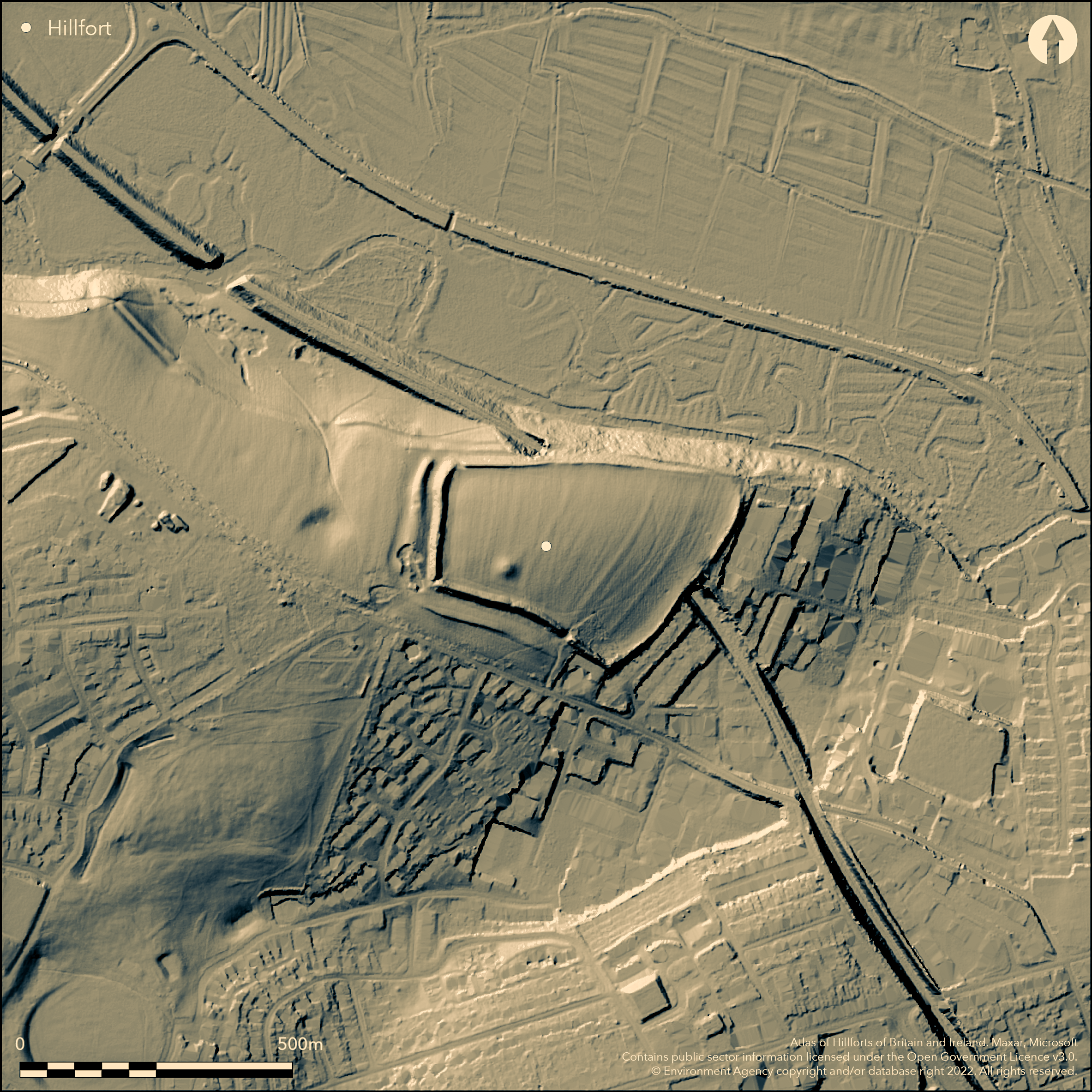
LiDAR 1m DTM Hillshade
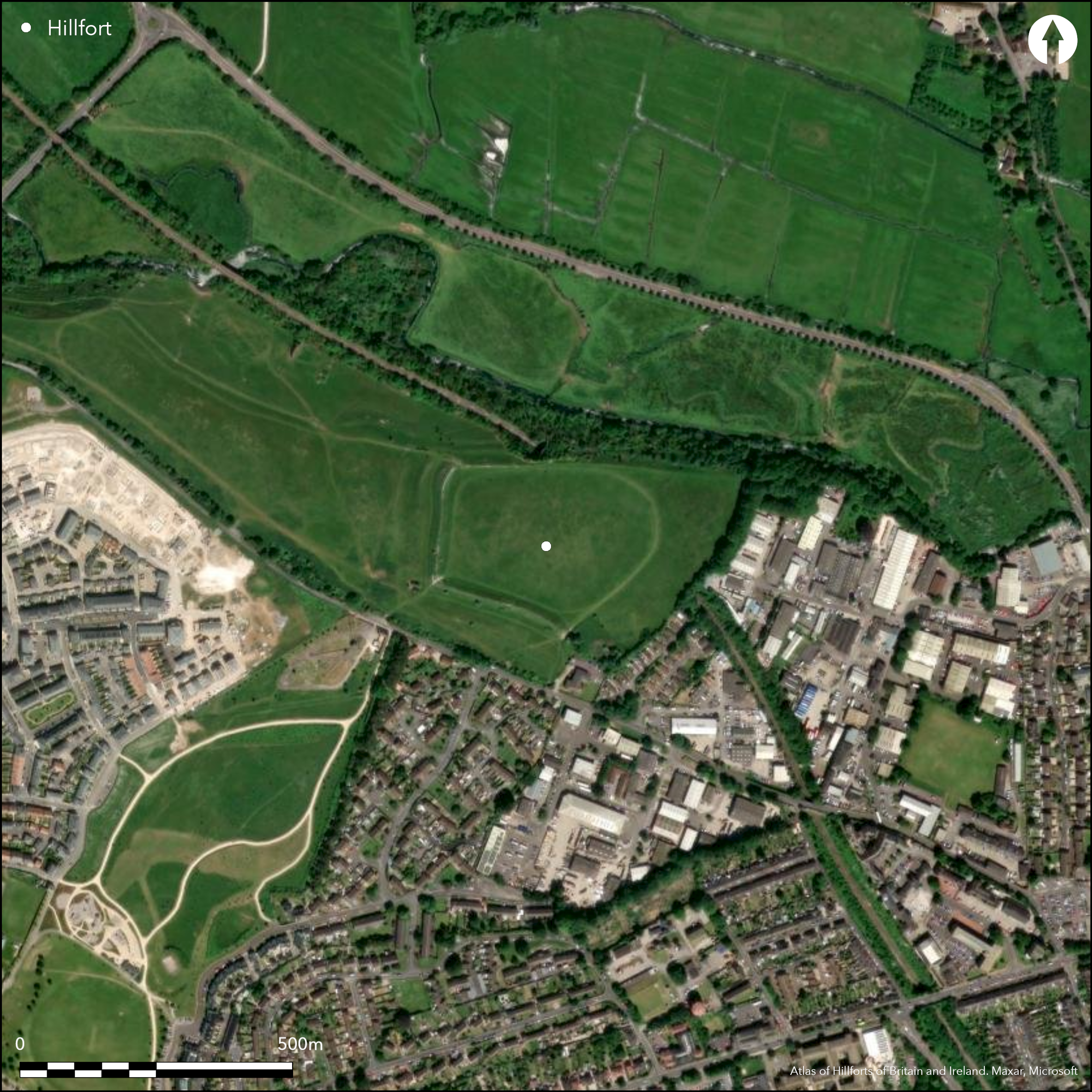
Satellite Imagery
LiDAR 1m DTM Hillshade
Satellite Imagery
Scroll left/right to view further images.
HER: Dorset MDO1057 (None)
NMR: SY 69 SE 63 (453395)
SM: 1013337
NGR: SY68259112
X: 368216 Y: 91141 (OSGB36)
Commanding, part bivallate, partial contour hillfort located on major chalk bluff/spur above River Frome to N at Dorchester. Steep to very steep slopes on N, moderate elsewhere. Hillfort forms central focus of major settlement complex spanning four millennia from at least late Neolithic, and maybe Mesolithic. Total complex includes Neolithic settlement of 3rd millennium BC; substantial Bronze Age huts, pits and field systems; the extensive Iron Age hillfort and associated earthworks, plus other structures, enclosures and related burials of late Iron Age. Also section of Roman aqueduct incorporated in W and N of hillfort. On E half of bluff earlier Romano-British farmstead and, adjacent to hillfort, extensive later cemetery, possibly Christian, belonging to Roman civitas of Durnovaria, with further buildings and enclosures of 5th-8th centuries. Trapezoidal in plan site encloses c. 5.4ha of spur. Three excavations during 1880 to 1980 (Richardson 1940; Green 1987). Formerly defined by two banks and ditches on three sides, best on W, but on N, where strong natural slope, an inner bank and scarp between two ditches which merged into one near NE corner, appearing as two terraces, outer rampart seemingly levelled by construction of Roman contour aqueduct which runs between inner and outer ditch. Double ramparts and intermediate ditch can now be traced around the S and W sides, but the outer ditch only on W. As result of building encroachment, now no remains of a terrace on E and no bank within the garden to SE. 1939-40 excavations showed two phases of construction. First inner bank with timber-faced palisade with internal quarries. Bank later enlarged by dump construction. Later outer bank and ditch of simple dump construction. Original causewayed entrance on E, those on SE, SW and NW modern. Pasture interior and banks on W quadrants, scrub on N. Major encroachment of Dorchester development to E and S. Inner bank relatively well-preserved, outer much damaged. On 1st Ed. OS map (1889).
Citizen Science: ✓
Reliability of Data: Confirmed
Reliability of Interpretation: Confirmed
X: -272914 Y: 6571730 (EPSG: 3857)
Longitude: -2.4516276894116844 Latitude: 50.71895471323753 (EPSG:4326)
Country: England; None
Current County or Unitary Authority: Dorset
Historic County: Dorset
Current Parish/Community/Council/Townland: Dorchester; Bradford Peverell
Major encroachment of Dorchester development on E and S. Inner bank relatively well-preserved, outer much damaged.
| Extant | ✓ |
| Cropmark | ✗ |
| Likely Destroyed | ✓ |
Pasture interior and banks on W quadrants, scrub on N. Building encroachment and WWII features.
| Woodland | ✗ |
| Commercial Forestry Plantation | ✗ |
| Parkland | ✗ |
| Pasture (Grazing) | ✓ |
| Arable | ✗ |
| Scrub/Bracken | ✓ |
| Bare Outcrop | ✗ |
| Heather/Moorland | ✗ |
| Heath | ✗ |
| Built-up | ✓ |
| Coastal Grassland | ✗ |
| Other | ✓ |
Commanding, part bivallate, partial contour hillfort located on a major chalk bluff above River Frome on N quadrants. Steep to very steep slopes on N, moderate elsewhere.
| Contour Fort | ✗ |
| Partial Contour Fort | ✓ |
| Promontory Fort | ✗ |
| Hillslope Fort | ✗ |
| Level Terrain Fort | ✗ |
| Marsh Fort | ✗ |
| Multiple Enclosure Fort | ✗ |
| Hilltop | ✗ |
| Coastal Promontory | ✗ |
| Inland Promontory | ✗ |
| Valley Bottom | ✗ |
| Knoll/Hillock/Outcrop | ✓ |
| Ridge | ✗ |
| Cliff/Plateau-edge/Scarp | ✗ |
| Hillslope | ✗ |
| Lowland | ✗ |
| Spur | ✓ |
Dominant Topographic Feature: Chalk bluff
| North | ✓ |
| Northeast | ✗ |
| East | ✗ |
| Southeast | ✗ |
| South | ✗ |
| Southwest | ✗ |
| West | ✗ |
| Northwest | ✗ |
| Level | ✗ |
Altitude: 94.0m
Boundary Type: Parish/Townland
Finds mostly Roman. Scattered finds of 4th century pottery in ditches and interior of fort from 1939 excavations suggest activity in or near Poundbury in 4th century, and coin hoard c. AD 353 in W inner ditch. Gouge-shaped bone tool of probably Iron Age and degenerate bead rim pottery.
Reliability: B - Medium
| Pre 1200BC | ✗ |
| 1200BC - 800BC | ✗ |
| 800BC - 400BC | ✗ |
| 400BC - AD50 | ✓ |
| AD50 - AD400 | ✓ |
| AD400 - AD 800 | ✗ |
| Post AD800 | ✗ |
| Unknown | ✗ |
| Pre Hillfort: | None |
| Post Hillfort: | None |
| Artefactual: | Roman and Iron Age pottery. |
Known to antiquaries from 16th century, first recorded with section drawings 1855 in cutting of railway. On 1st Ed. OS map (1889). Excavated by E. Cunnington 1880 and in 1939-40 by K.M. Richardson on W defences, with later excavation 1966-79 (break 1977-78) by C.J.S. Green. Geophysical survey 1973. Desk assessment Wessex Archaeology 1998. Excavation of E defences near NE corner 1980 prior to extension of existing car park. Watching Brief Terrain Archaeology 2002. Excavations in 1971 took place outside the hillfort to NE of E entrance in Roman cemetery. LiDAR survey Citizen Science information 2014. Visit by the Hillfort Study Group 2016.
| Excavation (1880): | E.Cunnington. |
| 1st Identified Map Depiction (1889): | OS map. |
| Geophysical Survey (1973): | AML survey. |
| Excavation (1980): | Excavation of E defences near NE corner 1980 prior to extension of existing car park. |
| Other (1998): | Desk assessment Wessex Archaeology. |
| Other (2002): | Watching Brief Terrain Archaeology. |
| LiDAR Survey (2014): | Citizen Science information. |
| Other (2016): | Visit by the Hillfort Study Group |
| 1st Identified Written Reference (None): | Known to antiquaries since 16th century, first recorded with section drawings in cutting of railway 1855. |
| Excavation (None): | K.M. Richardson. |
| Excavation (None): | C.J.S. Green |
Oval marks in SE corner possibly hut circles and square mark NE of the existing barrow possible Romano-Celtic temple, visible on 1976 air photographs. Finds mostly Roman. Scattered finds of 4th century pottery in ditches and interior of fort from 1939 excavations suggest activity in or near Poundbury in 4th century, and coin hoard c. AD 353 in W inner ditch. Possible loose fragment of mosaic recovered from the river below Poundbury and coin of Faustina II also from the river. Crop mark in interior possible building. Roman burial. Brooch c. AD 25-60 and another debased and spur. Gouge-shaped bone tool of probably Iron Age and degenerate bead rim pottery. Small bronze bowl and votive axe-head discovered 1943 probably foundation deposit beneath one of buildings. Bronze Age features.
None
| None | ✓ |
| Spring | ✗ |
| Stream | ✗ |
| Pool | ✗ |
| Flush | ✗ |
| Well | ✗ |
| Other | ✗ |
None
| No Known Features | ✓ |
| Round Stone Structures | ✗ |
| Rectangular Stone Structures | ✗ |
| Curvilinear Platforms | ✗ |
| Other Roundhouse Evidence | ✗ |
| Pits | ✗ |
| Quarry Hollows | ✗ |
| Other | ✗ |
Substantial Bronze Age huts, pits and field systems (included as other as part of early settlement complex). Quite likely that major interior excavations would reveal Iron Age pits similar to neighbouring Maiden Casle, but conjecture and no evidence at present.
| No Known Excavation | ✗ |
| Pits | ✗ |
| Postholes | ✗ |
| Roundhouses | ✗ |
| Rectangular Structures | ✗ |
| Roads/Tracks | ✗ |
| Quarry Hollows | ✗ |
| Other | ✓ |
| Nothing Found | ✗ |
1973 survey by AML to ascertain Roman features.
| No Known Geophysics | ✗ |
| Pits | ✗ |
| Roundhouses | ✗ |
| Rectangular Structures | ✗ |
| Roads/Tracks | ✗ |
| Quarry Hollows | ✗ |
| Other | ✓ |
| Nothing Found | ✗ |
Finds mostly Roman. Scattered finds of 4th century pottery in ditches and interior of fort from 1939 excavations suggest activity in or near Poundbury in 4th century, and coin hoard c. AD 353 in W inner ditch. Possible loose fragment of mosaic recovered from the river below Poundbury and coin of Faustina II also from the river. Crop mark in interior possible building. Roman burial. Brooch c. AD 25-60 and another debased and spur. Gouge-shaped bone tool of probably Iron Age and degenerate bead rim pottery. Small bronze bowl and votive axe-head discovered 1943 probably foundation deposit beneath one of buildings.
| No Known Finds | ✗ |
| Pottery | ✓ |
| Metal | ✓ |
| Metalworking | ✗ |
| Human Bones | ✓ |
| Animal Bones | ✗ |
| Lithics | ✗ |
| Environmental | ✗ |
| Other | ✗ |
Oval marks in SE corner possibly hut circles and square mark NE of the existing barrow possible Romano-Celtic temple, visible on 1976 air photographs.
| APs Not Checked | ✗ |
| None | ✗ |
| Roundhouses | ✓ |
| Rectangular Structures | ✗ |
| Pits | ✗ |
| Postholes | ✗ |
| Roads/Tracks | ✗ |
| Other | ✓ |
Original causewayed entrance on E, those on SE, SW and NW modern. 1855 railway tunnel below.
| 4: | SE, SW and NW gaps modern. |
| 2: | None |
Guard Chambers: ✗
Chevaux de Frise: ✗
| 1. Simple Gap (East): | Ditch crossed by causeway. |
Formerly defined by two banks and ditches on three sides, best on W, but on N, where strong natural defence, an inner bank and scarp between two ditches which merged into one near NE corner, appearing as two terraces, outer rampart seemingly levelled by construction of Roman aqueduct which runs between inner and outer ditch. Double ramparts and intermediate ditch can now be traced around the S and W sides, but the outer ditch only on W. Formerly described, and as result of building encroachment, now no remains of a terrace on E and no bank within the garden to SE.
| Area 1: | 5.4ha. |
| Total: | 5.4ha. |
Total Footprint Area: Noneha.
None
| ✓ | 1939-40 excavations showed two phases of construction. First inner bank with timber-faced palisade with internal quarries. Bank later enlarged by dump construction. Later outer bank and ditch of simple dump construction. |
| ✓ | N quadrants above steep slope to River Frome. |
| NE Quadrant: | 1 |
| SE Quadrant: | 2 |
| SW Quadrant: | 2 |
| NW Quadrant: | 1 |
| Total: | 2 |
| Partial Univallate | ✓ |
| Univallate | ✗ |
| Partial Bivallate | ✓ |
| Bivallate | ✗ |
| Partial Multivallate | ✗ |
| Multivallate | ✗ |
| Unknown | ✗ |
| Partial Univallate | ✗ |
| Univallate | ✓ |
| Partial Bivallate | ✗ |
| Bivallate | ✗ |
| Partial Multivallate | ✗ |
| Multivallate | ✗ |
Possible berm.
| None | ✗ |
| Earthen Bank | ✓ |
| Stone Wall | ✗ |
| Rubble | ✗ |
| Wall-walk | ✗ |
| Evidence of Timber | ✗ |
| Vitrification | ✗ |
| Other Burning | ✗ |
| Palisade | ✗ |
| Counter Scarp Bank | ✗ |
| Berm | ✓ |
| Unfinished | ✗ |
| Other | ✗ |
Pre-WWII excavation found Inner rampart revetted by wood and later stone walling. Excavation of E defences near NE corner 1980 found section of inner ditch near the foot of the inner rampart steep-sided V-shaped ditch 3.65m deep and 7.60m wide at top and separated by 13m gap to outer ditch. No trace of the outer ditch and possibly destroyed during construction of Roman Aqueduct. Later banks of dump construction.
| None | ✗ |
| Earthen Bank | ✓ |
| Stone Wall | ✓ |
| Murus Duplex | ✗ |
| Timber-framed | ✓ |
| Timber-laced | ✗ |
| Vitrification | ✗ |
| Other Burning | ✗ |
| Palisade | ✓ |
| Counter Scarp Bank | ✗ |
| Berm | ✗ |
| Unfinished | ✗ |
| No Known Excavation | ✗ |
| Other | ✓ |
| ✗ | None |
| ✓ | Ditches variable. Excavation of E defences near NE corner 1980 found section of inner ditch near the foot of the inner rampart steep-sided V-shaped ditch 3.65m deep and 7.60m wide at top and separated by 13m gap to outer ditch. No trace of the outer ditch and possibly destroyed during construction of Roman Aqueduct. |
Number of Ditches: 2
| ✗ | None |
Bartlett, A. 1973. Geophysics: Poundbury, Dorchester , AML Rep No 1610.
Davies, S. M. and Grieve, D. 1986. The Poundbury Pipeline: Archaeological Observations and Excavation, Proc Dorset Natur Hist Archaeol Soc, 108,
Davies, S. M., Harding, P. and Soames, R. 1987. Recent excavations at the Grove Trading Estate, Dorchester 1987, Proc Dorset Natur Hist Archaeol Soc, 109,81-88.
Ellis, C. 1998. Poundbury Development Phase II, Bridport Road, Dorchester, Dorset: archaeological desk-based assessment, Wessex Archaeology Report.
Gale, J. 2003. Prehistoric Dorset, Stroud: Tempus Publishing.
Green, C. J. S. 1987. Excavations at Poundbury Vol I, The settlements, Dorset Natur Hist Archaeol Soc Monograph 7, 130-33.
RCHME 1970. An inventory of historical monuments in the County of Dorset, Vol 2, pt 2: south-east, No 172, 488, London: RCHME.
Richardson, K. M. 1940. Excavations at Poundbury, Dorchester, Dorset, 1939, Antiq. J, 20, (4), 429-48.
Tatler S., Bellamy P. and Montague, R. 2002. Units 1-3, Cooper's Cookers, Grove Trading Estate, Dorchester: archaeological observations and recording, Terrain Archaeology Report No 53089.01.
Wheeler, R.E.M. 1943. Maiden Castle, Dorset, Research Committee of the Society of Antiquaries of London, Rept 12, Oxford.
Atlas of Hillforts:
Wikidata:
This work is licensed under CC BY-SA 4.0![]()
![]()
![]() and should be cited as:
and should be cited as:
Lock, Gary and Ralston, Ian. 2024. Atlas of Hillforts of Britain and Ireland. Available at: https://hillforts.arch.ox.ac.uk
Document Version 1.1