LiDAR 1m DTM Hillshade
Satellite Imagery
LiDAR 1m DTM Hillshade
Satellite Imagery
Scroll left/right to view further images.
HER: West Sussex MWS6482 (None)
NMR: SU 72 SE 3 (243008)
SM: 1015966
NGR: SU779202
X: 477871 Y: 120308 (OSGB36)
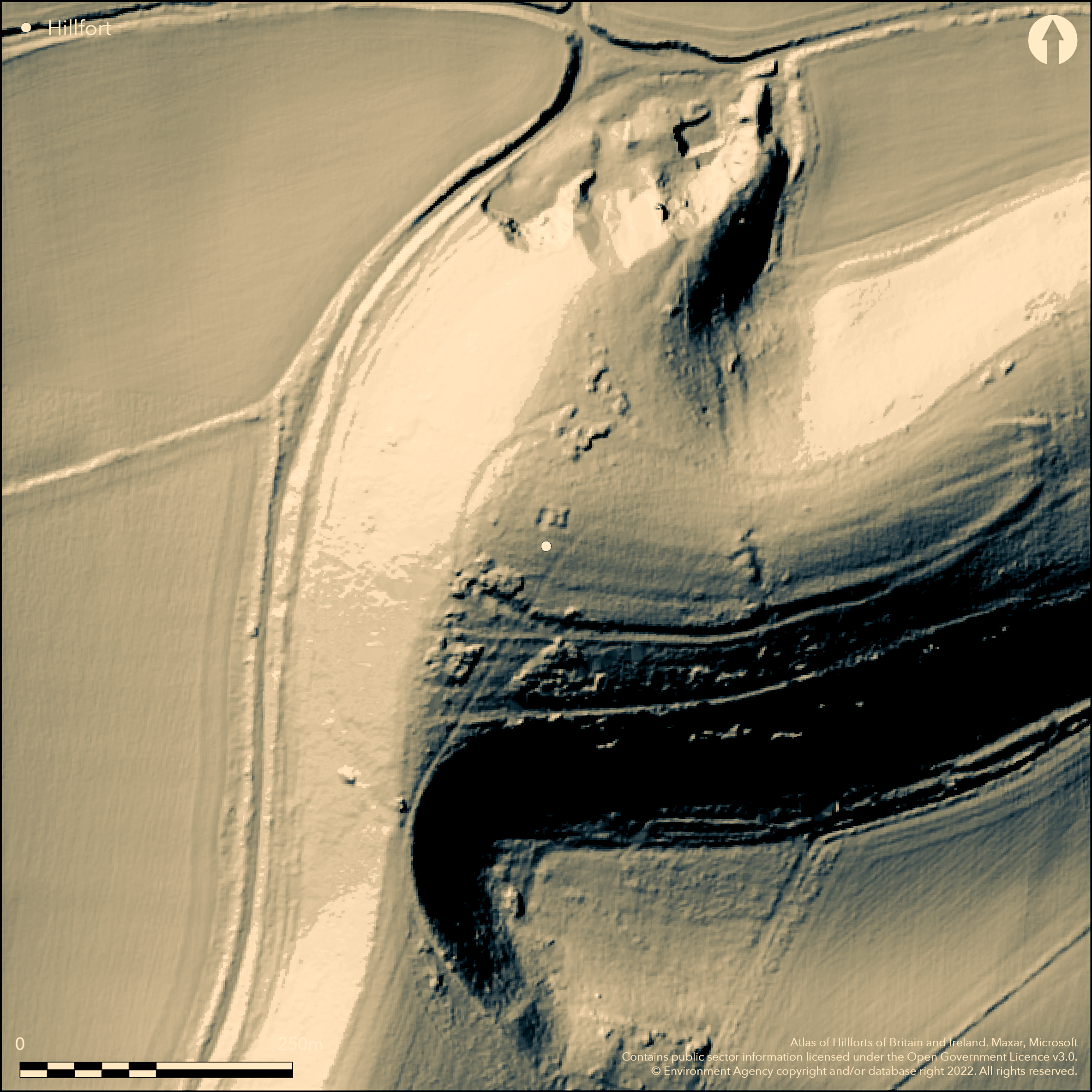
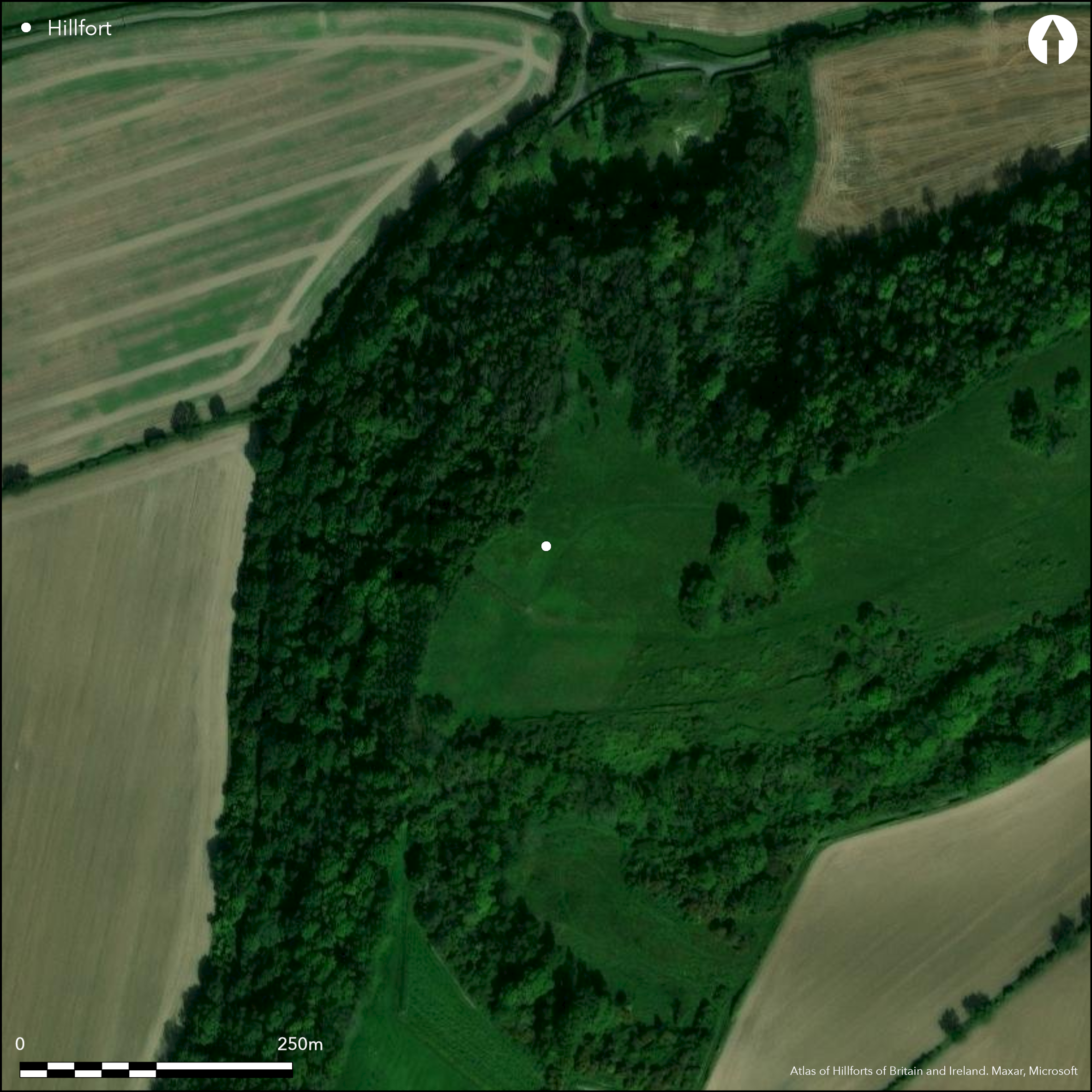
Slight, univallate, contour hillfort located on chalk spur projecting to N from a ridge of Sussex Downs. Pear-shaped aligned E-W enclosing c. 2.8ha. Defined by low bank or scarp surrounded by a mainly infilled ditch. Part excavation 1948 and 1956-58 (unpublished) indicated phased reconstruction and modification from the early Iron Age with use to 100 BC. 5th-3rd centuries BC defined as promontory fort, with N-S ditch and timber-reinforced bank across centre protecting W end of the steeply-sided spur. During 3rd century BC, ramparts enclosed whole spur-top, and new entrance on E. This gate modified during 2nd century BC with inturned stone-walled passage leading to timber gate, destroyed c. 100 BC. Now infilled pits in interior with Iron Age pottery. Medieval flour-milling post-mill foundation mound, the 'Fairy Bed' in W sector of earlier enclosure. Pasture interior with scattered trees, wooded surrounds. Plough damage but survives fairly well. On OS 1:25,000 map (1958).
Citizen Science: ✗
Reliability of Data: Confirmed
Reliability of Interpretation: Confirmed
X: -99318 Y: 6617202 (EPSG: 3857)
Longitude: -0.8921858642386277 Latitude: 50.97686514182909 (EPSG:4326)
Country: England
Current County or Unitary Authority: West Sussex
Historic County: Sussex
Current Parish/Community/Council/Townland: Harting
Plough damage, but survives fairly well.
| Extant | ✓ |
| Cropmark | ✗ |
| Likely Destroyed | ✗ |
Pasture interior with scattered trees, wooded surrounds. Medieval foundations.
| Woodland | ✓ |
| Commercial Forestry Plantation | ✗ |
| Parkland | ✗ |
| Pasture (Grazing) | ✓ |
| Arable | ✗ |
| Scrub/Bracken | ✗ |
| Bare Outcrop | ✗ |
| Heather/Moorland | ✗ |
| Heath | ✗ |
| Built-up | ✗ |
| Coastal Grassland | ✗ |
| Other | ✓ |
Slight univallate hillfort located chalk spur projecting to N from a ridge of Sussex Downs.
| Contour Fort | ✓ |
| Partial Contour Fort | ✗ |
| Promontory Fort | ✗ |
| Hillslope Fort | ✗ |
| Level Terrain Fort | ✗ |
| Marsh Fort | ✗ |
| Multiple Enclosure Fort | ✗ |
| Hilltop | ✓ |
| Coastal Promontory | ✗ |
| Inland Promontory | ✗ |
| Valley Bottom | ✗ |
| Knoll/Hillock/Outcrop | ✗ |
| Ridge | ✗ |
| Cliff/Plateau-edge/Scarp | ✗ |
| Hillslope | ✗ |
| Lowland | ✗ |
| Spur | ✓ |
Dominant Topographic Feature: Spur
| North | ✗ |
| Northeast | ✗ |
| East | ✗ |
| Southeast | ✗ |
| South | ✗ |
| Southwest | ✗ |
| West | ✗ |
| Northwest | ✗ |
| Level | ✓ |
Altitude: 156.0m
N/A
Part excavation 1948 and 1956-58 indicated phased reconstruction and modification from the early Iron Age with use to 100 BC. Iron Age pottery.
Reliability: B - Medium
| Pre 1200BC | ✗ |
| 1200BC - 800BC | ✗ |
| 800BC - 400BC | ✓ |
| 400BC - AD50 | ✓ |
| AD50 - AD400 | ✗ |
| AD400 - AD 800 | ✗ |
| Post AD800 | ✗ |
| Unknown | ✗ |
| Pre Hillfort: | None |
| Post Hillfort: | None |
| Artefactual: | Iron Age pottery. |
| Morphology/Earthwork/Typology: | Excavation evidence. |
On OS 1:25,000 map (1958). Excavation A.R. Taylor, H. Brightwell 1947-49. Excavation E. Bawtry, J.R. Boyden, G.C. Duncan 1956-58.
| 1st Identified Map Depiction (1958): | None |
| Excavation (None): | A.R. Taylor, H. Brightwell |
| Excavation (None): | E. Bawtry, J.R. Boyden, G.C. Duncan |
Now infilled pits with Iron Age pottery.
None
| None | ✓ |
| Spring | ✗ |
| Stream | ✗ |
| Pool | ✗ |
| Flush | ✗ |
| Well | ✗ |
| Other | ✗ |
None
| No Known Features | ✓ |
| Round Stone Structures | ✗ |
| Rectangular Stone Structures | ✗ |
| Curvilinear Platforms | ✗ |
| Other Roundhouse Evidence | ✗ |
| Pits | ✗ |
| Quarry Hollows | ✗ |
| Other | ✗ |
Now infilled pits.
| No Known Excavation | ✗ |
| Pits | ✓ |
| Postholes | ✗ |
| Roundhouses | ✗ |
| Rectangular Structures | ✗ |
| Roads/Tracks | ✗ |
| Quarry Hollows | ✗ |
| Other | ✗ |
| Nothing Found | ✗ |
None
| No Known Geophysics | ✓ |
| Pits | ✗ |
| Roundhouses | ✗ |
| Rectangular Structures | ✗ |
| Roads/Tracks | ✗ |
| Quarry Hollows | ✗ |
| Other | ✗ |
| Nothing Found | ✗ |
Iron Age pottery.
| No Known Finds | ✗ |
| Pottery | ✓ |
| Metal | ✗ |
| Metalworking | ✗ |
| Human Bones | ✗ |
| Animal Bones | ✗ |
| Lithics | ✗ |
| Environmental | ✗ |
| Other | ✗ |
None
| APs Not Checked | ✓ |
| None | ✗ |
| Roundhouses | ✗ |
| Rectangular Structures | ✗ |
| Pits | ✗ |
| Postholes | ✗ |
| Roads/Tracks | ✗ |
| Other | ✗ |
During third century BC, ramparts enclosed whole spur-top, and new entrance on E. This gate modified during 2nd century BC with inturned stone-walled passage leading to timber gate, destroyed c. 100 BC.
| 1: | None |
| 2: | None |
Guard Chambers: ✗
Chevaux de Frise: ✗
| 1. Passage-way/Corridor (East): | None |
| 1. In-turned (East): | Gate modified during snd century BC with inturned stone-walled passage leading to timber gate, destroyed c. 100 BC. |
Defined by low bank or scarp surrounded by a mainly infilled ditch.
| Area 1: | 2.8ha. |
| Total: | 2.8ha. |
Total Footprint Area: Noneha.
None
| ✓ | Phased construction. |
| ✓ | None |
| NE Quadrant: | 1 |
| SE Quadrant: | 1 |
| SW Quadrant: | 1 |
| NW Quadrant: | 1 |
| Total: | 1 |
| Partial Univallate | ✗ |
| Univallate | ✓ |
| Partial Bivallate | ✗ |
| Bivallate | ✗ |
| Partial Multivallate | ✗ |
| Multivallate | ✗ |
| Unknown | ✗ |
| Partial Univallate | ✗ |
| Univallate | ✗ |
| Partial Bivallate | ✗ |
| Bivallate | ✗ |
| Partial Multivallate | ✗ |
| Multivallate | ✗ |
None
| None | ✗ |
| Earthen Bank | ✓ |
| Stone Wall | ✗ |
| Rubble | ✗ |
| Wall-walk | ✗ |
| Evidence of Timber | ✗ |
| Vitrification | ✗ |
| Other Burning | ✗ |
| Palisade | ✗ |
| Counter Scarp Bank | ✗ |
| Berm | ✗ |
| Unfinished | ✗ |
| Other | ✗ |
None
| None | ✓ |
| Earthen Bank | ✗ |
| Stone Wall | ✗ |
| Murus Duplex | ✗ |
| Timber-framed | ✗ |
| Timber-laced | ✗ |
| Vitrification | ✗ |
| Other Burning | ✗ |
| Palisade | ✗ |
| Counter Scarp Bank | ✗ |
| Berm | ✗ |
| Unfinished | ✗ |
| No Known Excavation | ✗ |
| Other | ✗ |
| ✗ | None |
| ✓ | Mainly infilled. |
Number of Ditches: 1
| ✗ | None |
Cunliffe, B, 1976. Iron Age Sites in Central Southern England, Council For British Archaeology Research Report, Vol. 16, 1-29.
Atlas of Hillforts:
Wikidata:
This work is licensed under CC BY-SA 4.0![]()
![]()
![]() and should be cited as:
and should be cited as:
Lock, Gary and Ralston, Ian. 2024. Atlas of Hillforts of Britain and Ireland. Available at: https://hillforts.arch.ox.ac.uk
Document Version 1.1