LiDAR 1m DTM Hillshade
Satellite Imagery
LiDAR 1m DTM Hillshade
Satellite Imagery
Scroll left/right to view further images.
HER: Somerset 54552 (None)
NMR: ST 62 NW 1 (199646)
SM: 1011980
NGR: ST628251
X: 362800 Y: 125100 (OSGB36)
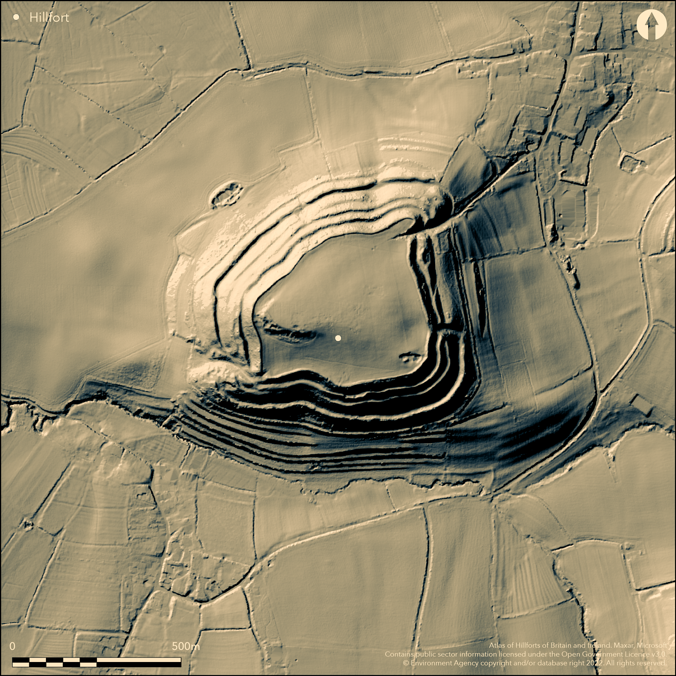
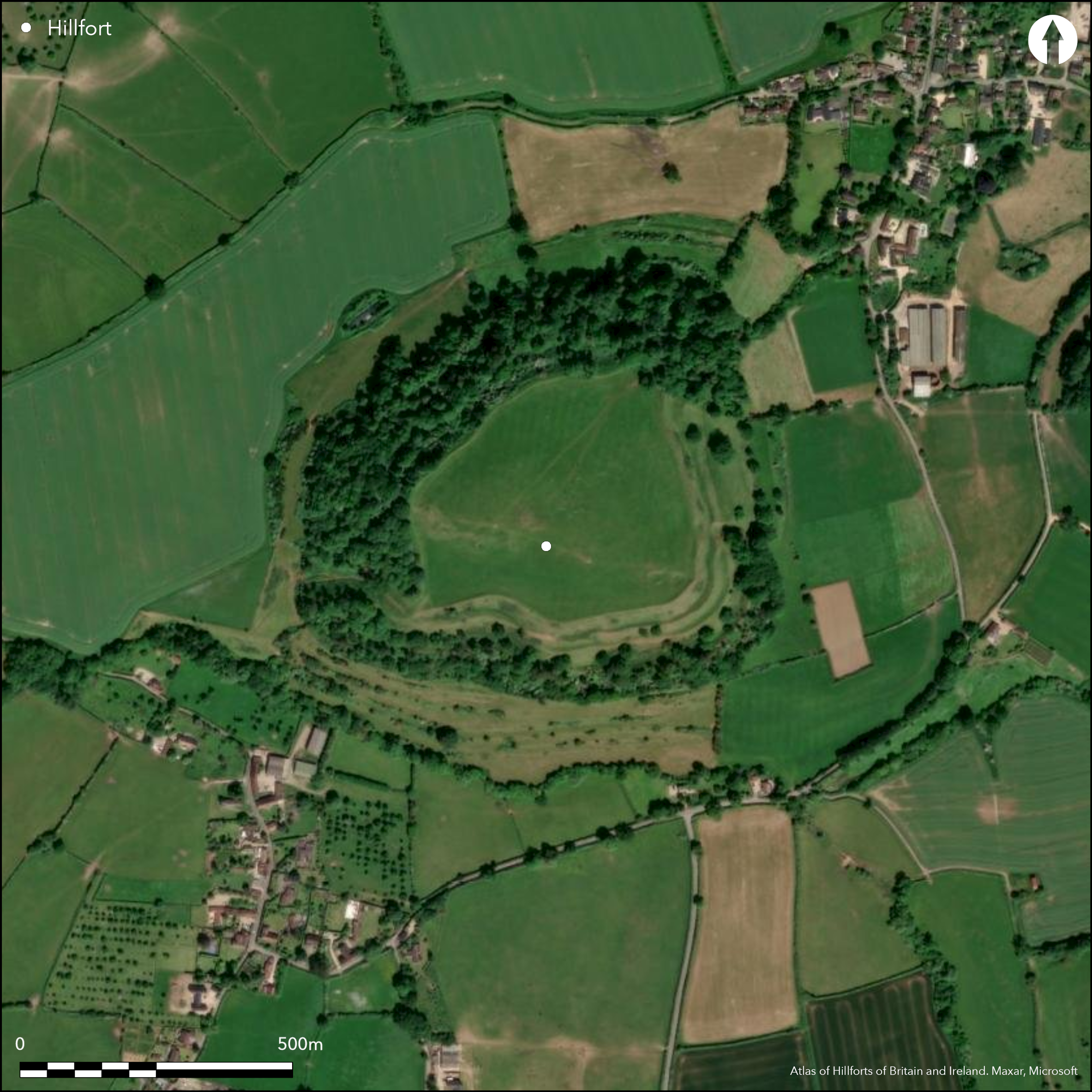
Outstanding, large and commanding, multivallate contour hillfort located on summit of Cadbury Hill, dome-shaped limestone outcrop above the Somerset Levels. Fine views N to Mendips, S and W, with Ham Hill (Atlas No 0448) 18km to SW. Interior is small plateau at c. 153m ASL, dipping towards N and E and falling steeply to S (where quarried), W and NW to height of c. 130m ASL. Associated in legend with King Arthur attracted attention from Tudor times with John Leland 1542 calling the site 'Camallate', and drawn by William Stukely 1723. first formal plan by C.W. Dymond 19th century. Excavations began 19th century, with later H. St George Gray opening five trenches 1913. Camelot Research Committee founded 1965 and geophysics and excavations by Leslie Alcock 1966-70 and 1973. South Cadbury Environs Project of survey, test pits and targetted excavation and geophysics from 1992 to c. 2010. Hillfort has sub-rectangular interior, measuring 325m max. E-W by 290m N-S and area c. 7.5ha. Defined by multiple ramparts surrounding circuit, varying from 110m to 75m total width. Number of banks and ditches varies around circuit, but generally four massive banks and three ditches, latter showing as terraces in places. In places on N, S and W, height differential between bottom of outer bank and top of inner bank as much as 40m-50m, but on E this drops to c. 17m. Only two ramparts (upper two and medial ditch) now survive on NE due to cultivation, although breaks in slope down the hill possibly remains of the outer ramparts, later modified into lynchets and since been partially overlain by hill-wash. Three gaps in ramparts: NE, E and SW, all probable original gates, although E less certain. Latter has complex sequence of activity, including successive guard chambers and gate structures and deep curving passage through the massive W ramparts, now disturbed by excavation. Straight entrance passage on NE entrance main access into hillfort, and now deeply hollowed where crosses inner ramparts. E entrance has slightly curving passage, now possibly later blocked and uncertain how it fell into disuse, although possible that may be post-Roman or modern. Excavations at, complex sequence, SW gate found E and W guard chambers and site of so-called 'massacre' of c. 1st century AD and burning. Very many finds from much pottery, personal adornments (245 brooches/fragments), metal and metal working, harness and military equipment, agricultural and other tools, through to animal and human bone. Interior quarried in SE and SW (at least from 16th century), with bank and ditch proving early medieval use. Much cultivation in interior medieval to modern. Pasture interior and banks in part. Else wooded surrounds. On Heritage at Risk Register (2015). On 1st Ed. OS map (1887).
Citizen Science: ✗
Reliability of Data: Confirmed
Reliability of Interpretation: Confirmed
X: -281840 Y: 6625540 (EPSG: 3857)
Longitude: -2.531809386582547 Latitude: 51.0239996877549 (EPSG:4326)
Country: England
Current County or Unitary Authority: Somerset
Historic County: Somerset
Current Parish/Community/Council/Townland: South Cadbury
Quarried in SE and SW (badly) interior. Interior cultivated since medieval to modern, including WWII, and re-seeded 1952, and some modern ploughing shows behind inner rampart. As result interior paucity of surface evidence. Traces of excavation trenches 1966-1970 still show as depressions in interior. On Heritage at Risk Register (2015).
| Extant | ✓ |
| Cropmark | ✗ |
| Likely Destroyed | ✗ |
Pasture interior and banks in part. Else wooded surrounds.
| Woodland | ✗ |
| Commercial Forestry Plantation | ✗ |
| Parkland | ✗ |
| Pasture (Grazing) | ✓ |
| Arable | ✗ |
| Scrub/Bracken | ✗ |
| Bare Outcrop | ✗ |
| Heather/Moorland | ✗ |
| Heath | ✗ |
| Built-up | ✗ |
| Coastal Grassland | ✗ |
| Other | ✗ |
Outstanding, large and commanding, multivallate contour hillfort located on summit of Cadbury Hill, dome-shaped limestone outcrop above the Somerset Levels. Fine views N to Mendips, S and W, with Ham Hill (Atlas No 0448) 18km to SW. Interior is small plateau at c. 153m ASL, dipping towards N and E and falling steeply to S (where quarried), W and NW to height of c. 130m ASL.
| Contour Fort | ✓ |
| Partial Contour Fort | ✗ |
| Promontory Fort | ✗ |
| Hillslope Fort | ✗ |
| Level Terrain Fort | ✗ |
| Marsh Fort | ✗ |
| Multiple Enclosure Fort | ✗ |
| Hilltop | ✓ |
| Coastal Promontory | ✗ |
| Inland Promontory | ✗ |
| Valley Bottom | ✗ |
| Knoll/Hillock/Outcrop | ✗ |
| Ridge | ✗ |
| Cliff/Plateau-edge/Scarp | ✗ |
| Hillslope | ✗ |
| Lowland | ✗ |
| Spur | ✗ |
Dominant Topographic Feature: Hill top
| North | ✗ |
| Northeast | ✗ |
| East | ✗ |
| Southeast | ✗ |
| South | ✗ |
| Southwest | ✗ |
| West | ✗ |
| Northwest | ✗ |
| Level | ✓ |
Altitude: 153.0m
N/A
Activity on hill from Mesolithic to medieval periods. Earliest Iron Age occupation of hilltop c. 700 BC with ceramic jars and two bronze razors. sequences Cadbury I early Neolithic to Cadbury 10A Roman. 22 C14 samples, largely concentrating at either end of late Bronze Age to Roman sequence.
Reliability: A - High
| Pre 1200BC | ✗ |
| 1200BC - 800BC | ✗ |
| 800BC - 400BC | ✓ |
| 400BC - AD50 | ✓ |
| AD50 - AD400 | ✓ |
| AD400 - AD 800 | ✗ |
| Post AD800 | ✗ |
| Unknown | ✗ |
| Pre Hillfort: | None |
| Post Hillfort: | None |
| Artefactual: | Much dateable pottery and other artefacts. |
| C14: | 22 C14 samples, largely concentrating at either end of late Bronze Age to Roman sequence. |
Associated in legend with King Arthur attracted attention from Tudor times with John Leland 1542 calling the site 'Camallate', and drawn by William Stukely 1723. On 1st Ed. OS map (1887). First formal plan by C.W. Dymond 19th century. Excavations began 19th century by Rev. J.A. Bennett, with later H. St George Gray opening five trenches 1913. Camelot Research Committee founded 1965 and geophysics and excavations by Leslie Alcock 1966-70 and 1973. South Cadbury Environs Project of survey, test pits and targetted excavation and geophysics from 1992 to c. 2010. 1800- 1899 Excavation CADBURY CASTLE Nothing is known of the whereabouts of the archive or finds. Director of fieldwork REVEREND MR J A Bennett Publications : Reference Somerset archaeology and natural history : the proceedings of the Somersetshire Archaeological and Natural History Society 36/1890/2:1-19 PASSIM Note Virtual Catalogue Entry to support E.I. Migration ALCOCK,L./1972/BY SOUTH CADBURY IS THAT CAMELOT ../20 1913 Excavation CADBURY CASTLE Finds Holder Somerset County Museum Taunton Director of fieldwork H St G Gray Auspices Somerset Archaeological and Natural History Society Archive Holder Somerset Archaeological and Natural History Society Publications : Full report Somerset archaeology and natural history : the proceedings of the Somersetshire Archaeological and Natural History Society 59/1913/2:1-24 1966- 1973 Excavation CADBURY CASTLE, SOUTH CADBURY Excavation undertaken between 1966 and 1970, with a return to the site to cut back the face of an existing section in 1973. Archive to go to Somerset CRO after final report published. (Presently with University of Glasgow 1991). Work included soil conductivity survey. Auspices Cadbury Research Committee Funding Body/Financier University of Wales Cardiff Archaeology Department Archive Holder University of Glasgow Finds Holder Somerset County Museum Taunton Finds Holder L Alcock Director of fieldwork L Alcock Funding Body/Financier British Academy Funding Body/Financier Society of Antiquaries London Archive Holder L Alcock Publications : Reference Bulletin of the Board of Celtic Studies 28/1980/656-718 Full report Cadbury Castle Somerset: The later prehistoric and early historic archaeology by J C Barrett, P W M Freeman & A Woodward English Heritage archaeological reports Full report Cadbury Castle, Somerset : the early medieval archaeology by Leslie Alcock, in collaboration with S J Stevenson and C R Musson by L Alcock (1995) Note English Heritage archaeology review /1991-2/43-4 Note Somerset archaeology and natural history : the proceedings of the Somersetshire Archaeological and Natural History Society 136/1992 Interim report Virtual Catalogue Entry to support E.I. Migration ALCOCK,L./1972/By South Cadbury is that Camelot ... 1973 Excavation CADBURY CASTLE Archive to go to Taunton Museum after publication of final report. Finds Holder L Alcock Director of fieldwork L Alcock Archive Holder L Alcock Auspices Cadbury Research Committee Publications : Full report Bulletin of the Board of Celtic Studies 28/1980/4:656-718 Reference Cadbury Castle, Somerset : the early medieval archaeology by Leslie Alcock, in collaboration with S J Stevenson and C R Musson by L Alcock (1995), pp 10-12 Note English Heritage archaeology review /1991-2/43-4 1992- 1993 Geophysical Survey CADBURY CASTLE AML Survey Database Reference Nos: 985, 986 Survey Type: Resistivity: recorded grid Survey Type: Magnetometer: recorded grid Survey to provide alternative data to soil conductivity (SCM) survey of 1966-70 (see Event 634955). The earlier survey results were shown to be incomplete, but it was still considered impossible to postulate a 'town plan' for the hillfort in any particular period. See Event 1007366 for associated earthwork survey. Auspices University of Glasgow Department of Archaeology Archive Holder University of Glasgow Department of Archaeology Publications : Note Somerset archaeology and natural history : the proceedings of the Somersetshire Archaeological and Natural History Society 136/1992 Full report Virtual Catalogue Entry to support E.I. Migration Johnson P G/1993/Cadbury Castle, Somerset: geophysical surveys 1992-93. 1993 Measured Survey RCHME: South Cadbury South Cadbury Castle and its immediate environs were surveyed by staff from RCHME Exeter in 1993 in response to a request from English Heritage and the University of Glasgow Dept of Archaeology. The survey and field report will feature in the forthcoming publication of the prehistoric and Roman material from the 1966-70 & 1973 excavations. The site was surveyed during the winter and spring of 1993. At the time of the survey, the interior and southern defences of the hillfort were under pasture, while the northern, western and eastern defences had a cover of woodland and, in places, dense scrub. See Event 1124927 for associated geophysical survey. Publications : Full report Royal Commission on the Historical Monuments of England [assessment & evaluation reports] Riley H & Dunn C J/1993/South Cadbury Castle, Somerset: A new earthwork survey by the Royal Commission on the Historical Monuments of England. 1995- 1999 Excavation MILSOM'S CORNER, SUTTON MONTIS (SOUTH CADBURY ENVIRONS PROJECT) Excavation of an area c.422m sq followed gradiometer survey (EHGSDB Visit No: 1695) and fieldwalking. The earliest feature appears to be a line of pits along the crest of the ridge containing pottery of styles recorded at Windmill Hill and Hembury. A hiatus ensued prior to the construction of a ?Beaker rectilinear ditched enclosure, followed by intensive Iron Age occupation with circular buildings and a trackway. The site lies just below the south-west gate of Cadbury Castle. Those involved in the investigation included students from Bristol University Dept. Archaeology. CBA South West Journal 3 refers to the site as an 'undergraduate training excavation'. Finds Holder Somerset County Museum Taunton Auspices Birmingham University Field Archaeology Unit Auspices University of Glasgow Auspices South East Somerset Archaeological Society Director of fieldwork Peter Leach Publications : Reference Archaeology South West [the journal of Council for British Archaeology - South West] 3/1999 Interim report Archaeology South West [the journal of Council for British Archaeology - South West] 4/2000 Interim report Birmingham University Field Archaeology Unit [archaeological evaluation reports] 457/1996 Full report Birmingham University Field Archaeology Unit [archaeological evaluation reports] Leach P & Tabor R/1995/The South Cadbury Environs Project, Fieldwork Report 1995. Report No 374. Interim report Birmingham University Field Archaeology Unit [archaeological evaluation reports] Leach P & Tabor R/1998/The South Cadbury Environs Project: field report 1997. Journal article Current archaeology No 163/June 1999 Interim report Somerset archaeology and natural history : the proceedings of the Somersetshire Archaeological and Natural History Society 139/1996 Note Somerset archaeology and natural history : the proceedings of the Somersetshire Archaeological and Natural History Society 140/1997 Note Somerset archaeology and natural history : the proceedings of the Somersetshire Archaeological and Natural History Society 141/1998 Note Somerset archaeology and natural history : the proceedings of the Somersetshire Archaeological and Natural History Society 142/1999 Note Somerset archaeology and natural history : the proceedings of the Somersetshire Archaeological and Natural History Society 143/2001 Journal article Somerset Archaeology: Papers to mark 150 years of the Somerset Archaeological and Natural History Society C J Webster (ed) Journal article The archaeologist Institute of Field Archaeologists 40/S
| 1st Identified Written Reference (1542): | John Leland reference. |
| Other (1723): | Drawn by William Stukely |
| 1st Identified Map Depiction (1887): | OS map. |
| Excavation (1913): | H. St George Gray opening five trenches. |
| Other (1980): | Visit by Hillfort Study Group |
| Earthwork Survey (1993): | RCHME |
| Other (2016): | Visit by Hillfort Study Group |
| Geophysical Survey (None): | Geophysics by Leslie Alcock. |
| Excavation (None): | Excavations by Leslie Alcock. |
| Other (None): | South Cadbury Environs Project of survey, test pits and targetted excavation and geophysics. |
| Geophysical Survey (None): | RCHME/AML |
| Other (None): | First formal plan C.W. Dymond. |
| Excavation (None): | Rev. J. A. Bennett. |
Three probable quarry scoops on W. Because of cultivation of interior from medieval to modern, lack of surface features. Excavation of sample of 362 pits Many postholes. Evidence of roundhouses, rectangular structures, medieval hall, outlined in excavation report (Bartlett et al 2000). Successive geophysics showed many features, including pits and structures, outlined in detail in excavation report (Bartlett et al 2000). Very many finds from much pottery, personal adornments (245 brooches/fragments), metal and metal working, harness and military equipment, agricultural and other tools, through to animal and human bone. Outlined in detail in excavation report (Bartlett et al 2000). RAF flights for local amateur Mary Harfield 1955 found two hollow ways from NE gate to plateau and numerous probable pits.
Two water sources within probably prehistoric origin: stone/brick King Arthur's Well, S of passage to NE gate, and Queen Anne's Well now muddy spring.
| None | ✗ |
| Spring | ✓ |
| Stream | ✗ |
| Pool | ✗ |
| Flush | ✗ |
| Well | ✓ |
| Other | ✗ |
Three probable quarry scoops on W. Because of cultivation of interior from medieval to modern, lack of surface features.
| No Known Features | ✗ |
| Round Stone Structures | ✗ |
| Rectangular Stone Structures | ✗ |
| Curvilinear Platforms | ✗ |
| Other Roundhouse Evidence | ✗ |
| Pits | ✗ |
| Quarry Hollows | ✓ |
| Other | ✗ |
Excavation of sample of 362 pits Many postholes. Evidence of stake-walled roundhouses, rectangular structures, medieval hall, outlined in excavation report (Bartlett et al 2000).
| No Known Excavation | ✗ |
| Pits | ✓ |
| Postholes | ✓ |
| Roundhouses | ✓ |
| Rectangular Structures | ✓ |
| Roads/Tracks | ✗ |
| Quarry Hollows | ✗ |
| Other | ✓ |
| Nothing Found | ✗ |
Successive geophysics showed many features, including pits and structures, outlined in detail in excavation report (Bartlett et al 2000).
| No Known Geophysics | ✗ |
| Pits | ✓ |
| Roundhouses | ✓ |
| Rectangular Structures | ✓ |
| Roads/Tracks | ✓ |
| Quarry Hollows | ✗ |
| Other | ✗ |
| Nothing Found | ✗ |
Very many finds from much pottery, personal adornments (245 brooches/fragments), metal and metal working, harness and military equipment, agricultural and other tools, through to animal and human bone. Outlined in detail in excavation report (Bartlett et al 2000).
| No Known Finds | ✗ |
| Pottery | ✓ |
| Metal | ✓ |
| Metalworking | ✓ |
| Human Bones | ✓ |
| Animal Bones | ✓ |
| Lithics | ✓ |
| Environmental | ✓ |
| Other | ✓ |
RAF flights for local amateur Mary Harfield 1955 found two hollow ways from NE gate to plateau and numerous probable pits.
| APs Not Checked | ✗ |
| None | ✗ |
| Roundhouses | ✗ |
| Rectangular Structures | ✗ |
| Pits | ✓ |
| Postholes | ✗ |
| Roads/Tracks | ✓ |
| Other | ✗ |
Three gaps in ramparts: NE, E and SW, all probable original gates, although E less certain. Latter, probable main gate, has deep curving passage through the massive W ramparts and now disturbed by excavation, complex sequence and E and W guard chambers. Straight entrance passage on NE entrance main access into hillfort, and now deeply hollowed where crosses inner ramparts. E entrance has slightly curving passage, now possibly later blocked and uncertain how it fell into disuse, although possible that may be post-Roman or modern. All the gates have hollow ways associated.
| 3: | None |
| 2: | That on E less certain. |
Guard Chambers: ✓
Chevaux de Frise: ✗
| 1. Passage-way/Corridor (North east): | Straight entrance passage. |
| 1. Hollow Way (North east): | Deeply hollowed. |
| 2. Passage-way/Corridor (South west): | Complex sequence of activity and remodelling, with final destruction by fire. |
| 2. Recesses/Guard Chambers (South west): | E and W stone-built guard chambers. |
| 3. Blocked (East): | Passage way blocked by steep scarp. |
| 3. Passage-way/Corridor (East): | Slightly curving passage. |
Defined by multiple ramparts surrounding circuit, varying from 110m to 75m total width. Number of banks and ditches varies around circuit, but generally four massive banks and three ditches, latter showing as terraces in places. In places on N, S and W, height differential between bottom of outer bank and top of inner bank as much as 40m-50m, but on E this drops to c. 17m. Only two ramparts (upper two and medial ditch) now survive on NE due to cultivation, although breaks in slope down the hill possibly remains of the outer ramparts, later modified into lynchets and since been partially overlain by hill-wash. Much detail of construction of ramparts and ditches outlined in detail in excavation report (Bartlett et al 2000).
| Area 1: | 7.5ha. |
| Total: | 7.5ha. |
Total Footprint Area: Noneha.
None
| ✗ | Complex history of occupation of hill and phased construction of site - Cadbury I early Neolithic c. 4000 BC to Cadbury 10A Roman, outlined in excavation report (Barrett et al 2000). |
| ✓ | None |
| NE Quadrant: | 2 |
| SE Quadrant: | 4 |
| SW Quadrant: | 4 |
| NW Quadrant: | 4 |
| Total: | 4 |
| Partial Univallate | ✗ |
| Univallate | ✗ |
| Partial Bivallate | ✓ |
| Bivallate | ✗ |
| Partial Multivallate | ✓ |
| Multivallate | ✗ |
| Unknown | ✗ |
| Partial Univallate | ✗ |
| Univallate | ✗ |
| Partial Bivallate | ✗ |
| Bivallate | ✗ |
| Partial Multivallate | ✗ |
| Multivallate | ✗ |
None
| None | ✗ |
| Earthen Bank | ✓ |
| Stone Wall | ✗ |
| Rubble | ✗ |
| Wall-walk | ✗ |
| Evidence of Timber | ✗ |
| Vitrification | ✗ |
| Other Burning | ✗ |
| Palisade | ✗ |
| Counter Scarp Bank | ✗ |
| Berm | ✗ |
| Unfinished | ✗ |
| Other | ✗ |
Much detail of phased construction of ramparts and ditches outlined in detail in excavation report (Bartlett et al 2000). Includes stone and revetted bank.
| None | ✗ |
| Earthen Bank | ✓ |
| Stone Wall | ✓ |
| Murus Duplex | ✗ |
| Timber-framed | ✓ |
| Timber-laced | ✗ |
| Vitrification | ✗ |
| Other Burning | ✗ |
| Palisade | ✗ |
| Counter Scarp Bank | ✗ |
| Berm | ✗ |
| Unfinished | ✗ |
| No Known Excavation | ✗ |
| Other | ✗ |
| ✗ | None |
| ✓ | Three ditches showing as terraces in places. |
Number of Ditches: 3
| ✗ | None |
Alcock, L, 1972. By South Cadbury Is That Camelot. London: Thames & Hudson.
Brown, I. 2009. Beacons in the landscape. The hillforts of England and Wales, Oxford: Windgather Press/Oxbow Books.
Barrett, J.C., Freeman, P.W.M. and Woodward, A. 2000. Cadbury Castle Somerset. The later prehistoric and early historic archaeology, London: English Heritage.
Johnson, P.G. 1993. CADBURY CASTLE, SOMERSET. GEOPHYSICAL SURVEYS 1992-1993. AML Report, unpublished.
Tabor, R. 2008. Cadbury Castle. The hillfort and landscapes, Stroud: The History Press.
Atlas of Hillforts:
Wikidata:
This work is licensed under CC BY-SA 4.0![]()
![]()
![]() and should be cited as:
and should be cited as:
Lock, Gary and Ralston, Ian. 2024. Atlas of Hillforts of Britain and Ireland. Available at: https://hillforts.arch.ox.ac.uk
Document Version 1.1